
Mori Atlas logo
Nature reserveCoramba Nature Reserve

Geographic context of a rare protected forest remnant in the Clarence River valley system

Coramba Nature Reserve: Mapping Lowland Sub-Tropical Rainforests in Coastal New South Wales

Coramba Nature Reserve functions as a critical conservation sanctuary, protecting one of the few surviving patches of lowland sub-tropical rainforest on the New South Wales coast. Located within the Clarence River valley, this protected area preserves an ecological community that has otherwise largely disappeared from the surrounding lowlands. The site offers significant value for understanding remnant forest distribution and botanical diversity in an otherwise modified regional landscape.

lowland rainforestsub-tropical rainforestrainforest remnantClarence valleyMid North Coasthabitat conservation
Stylized digital illustration of a mountain valley featuring a central waterfall, a meandering river, and surrounding pine forests under a soft sky.

Coramba Nature Reserve

Nature reserve

Park overview

Structured park overview, official facts, and landscape profile for Coramba Nature Reserve

Coramba Nature Reserve park facts, protected area profile, and essential visitor context

Review the core facts for Coramba Nature Reserve, including designation, size, terrain, visitor scale, habitats, and operating context in one park-focused overview.

About Coramba Nature Reserve

Coramba Nature Reserve sits in the Clarence River valley near Coffs Harbour, on the Mid North Coast of New South Wales. The reserve sits in an area where the coastal ranges and valleys of eastern Australia create conditions suitable for sub-tropical rainforest at relatively low elevations. Unlike most rainforest environments in the region, which occur in more elevated or sheltered locations, the forest at Coramba represents a low altitude example of this community, making it biogeographically distinctive.

The reserve was established in 1982 with the explicit purpose of safeguarding what remained of the local lowland sub-tropical rainforest. By the time of its gazetting much of the surrounding landscape had already been cleared for agriculture, timber harvesting, and settlement, leaving only small scattered patches of the original forest. Coramba was preserved as one of those surviving remnants, valued for both its scientific interest and its representation of a vanishing ecological community.

Because the reserve is managed under an IUCN Category IV framework as a habitat and species management area, its primary management focus is the careful conservation of its forest community rather than the provision of broad visitor infrastructure. The site functions as a small, intensively conserved botanical sanctuary embedded within a broader landscape that has otherwise been heavily modified by human use.

Despite its modest footprint, Coramba Nature Reserve contributes meaningfully to regional biodiversity conservation in New South Wales. It preserves the structure, composition, and ecological functioning of lowland sub-tropical rainforest in a part of the state where such forest has otherwise become rare. In this sense, the reserve plays an outsize role in protecting a distinctive slice of New South Wales's natural heritage.

Quick facts and research context for Coramba Nature Reserve

Coramba Nature Reserve lies on the Mid North Coast of New South Wales, just inland from Coffs Harbour, in the broader Clarence River valley region of eastern Australia. It is classified as an IUCN Category IV protected area, focused on habitat and species management, and is administered by the NSW National Parks and Wildlife Service.

The reserve protects one of the few surviving lowland sub-tropical rainforest remnants in the Clarence valley, an ecosystem type that has been extensively reduced by clearing elsewhere in the region. Its small footprint and targeted conservation role give it a research and ecological value greater than its area alone would suggest.

Protection and recognition

Documented terrestrial protection metrics and official international recognition records for Coramba Nature Reserve.

Coramba Nature Reserve Protection Status and Designated Terrestrial Conservation Scope

Coramba Nature Reserve maintains a documented terrestrial protection scope without imported international recognition sources or transboundary classifications. Structured conservation data indexes the official designation framework and administrative parameters governing the protected area.

Protection details

Protection scope
Terrestrial
Transboundary protection
No
Park context

Deeper park guide and search-rich context for Coramba Nature Reserve

Coramba Nature Reserve history, landscape, wildlife, and travel context

Explore Coramba Nature Reserve through its history, landscape character, ecosystems, wildlife, conservation priorities, cultural context, and seasonal travel timing in a structured park guide built for atlas discovery and search intent.

Why Coramba Nature Reserve stands out

Coramba Nature Reserve is best known for protecting one of the very few remaining examples of low altitude sub-tropical rainforest in the Clarence River valley, an ecosystem type that has otherwise largely disappeared from the coastal lowlands of northern New South Wales. The reserve is also recognized for the diversity of rainforest tree species packed into a small area, including white booyong, red cedar, Oliver's sassafras, and other characteristic sub-tropical rainforest species. Together, these features make Coramba a notable reference site for lowland sub-tropical rainforest conservation on the New South Wales coast.
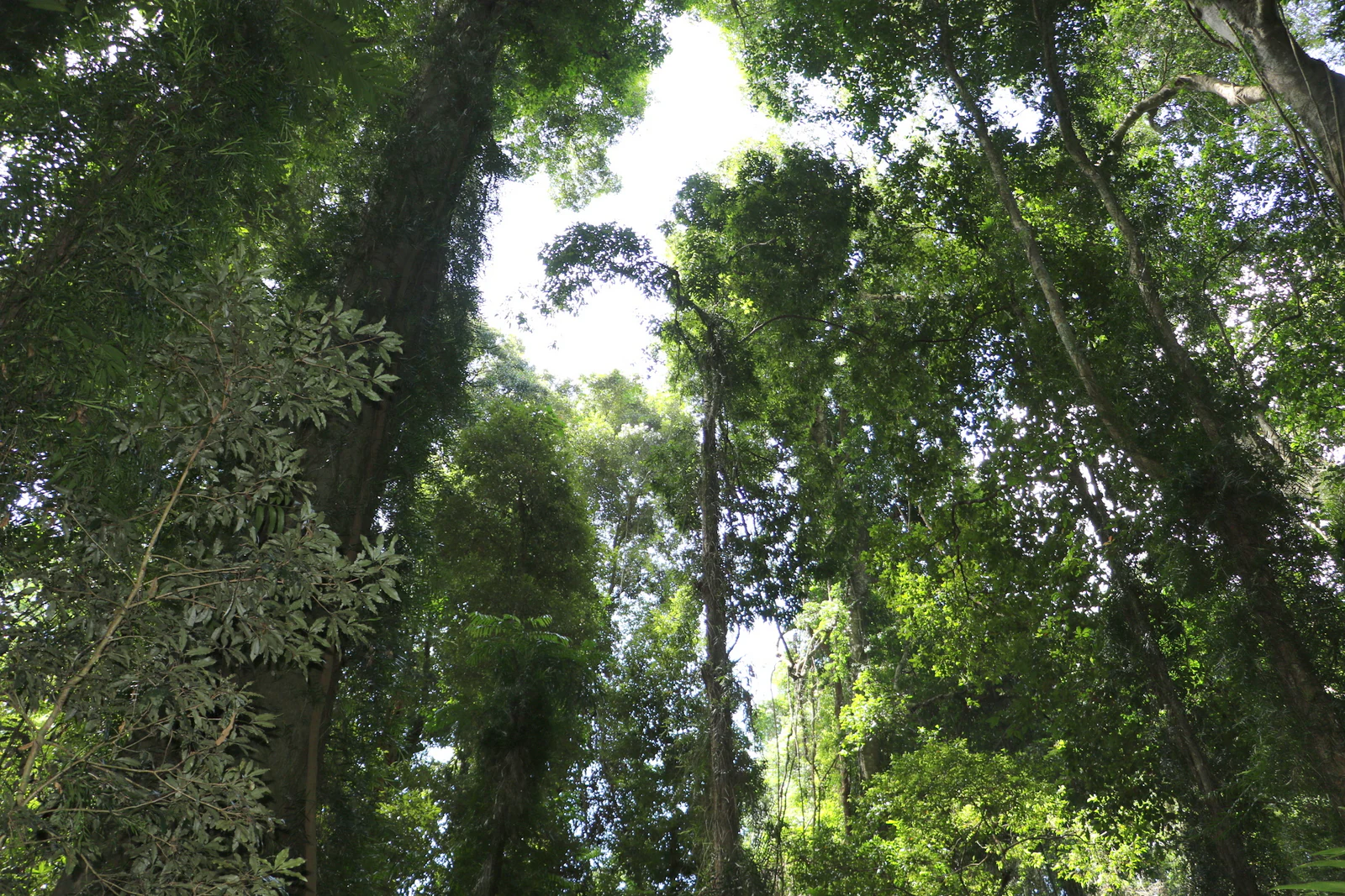
Looking upward through the dense green canopy of a subtropical rainforest with tall tree trunks reaching toward the sky.
Low altitude subtropical rainforest canopy at Coramba Nature Reserve.

Coramba Nature Reserve history and protected-area timeline

Coramba Nature Reserve was gazetted in 1982, with the principal aim of protecting the small remaining area of low altitude sub-tropical rainforest in the Clarence River valley. Its creation reflected a growing recognition during the late twentieth century that lowland sub-tropical rainforest had been extensively cleared across the New South Wales coastal lowlands, and that the surviving fragments deserved formal protection.

By the time the reserve was established, the surrounding landscape had already been substantially modified by agricultural development, selective logging, and the expansion of rural settlement around towns such as Coffs Harbour. The remaining rainforest at Coramba was therefore recognized as a rare ecological reference point for what the broader lowland forests of the region once looked like.

Since its establishment the reserve has been administered by what is now the NSW National Parks and Wildlife Service as a habitat and species management reserve, consistent with its small size and targeted conservation purpose. Its ongoing management continues to prioritize the maintenance of the rainforest community and the protection of the tree species and habitat structure that define it.

Coramba Nature Reserve landscape and geographic character

The landscape of Coramba Nature Reserve is defined primarily by its forest cover rather than by dramatic topography. The reserve occupies a small footprint in the Clarence River valley close to the coast, where elevations are low and the terrain is shaped by the broader drainage patterns of the valley system. Within this setting the terrain is comparatively gentle, and the visual character of the reserve is dominated by its dense sub-tropical rainforest canopy.

The low altitude of the site is one of its most important landscape features. Unlike many of the more elevated or sheltered rainforest environments further inland or further north, Coramba demonstrates how sub-tropical rainforest can persist at low elevation in a coastal valley when topography, rainfall, and microclimate align favorably. This gives the reserve a particular landscape identity that distinguishes it from other rainforest sites in the region.

The broader surrounding landscape is dominated by a mix of cleared farmland, rural residential areas, secondary forest, and patches of regrowth. Within this matrix Coramba stands out as a dense, tall, structurally complex remnant of original forest, reinforcing the sense that the reserve is a self-contained ecological fragment embedded in an otherwise heavily modified regional environment.

Coramba Nature Reserve ecosystems, habitats, and plant life

Ecologically, Coramba Nature Reserve belongs to the lowland sub-tropical rainforest community, one of the most restricted and threatened forest types in coastal New South Wales. The rainforest here is structured in the classic sub-tropical manner, with a closed upper canopy, a mid-storey layer of smaller trees and shrubs, and a shaded forest floor rich in leaf litter and fallen timber.

The low elevation of the reserve is unusual for sub-tropical rainforest in this part of New South Wales, and it gives the site particular ecological relevance. Many comparable rainforest communities elsewhere are found at higher altitudes or in more sheltered mountain environments, making the Coramba forest an important example of the ecological niche once occupied by lowland sub-tropical rainforest across the broader Clarence valley.

The combination of warm temperatures, reliable rainfall, and sheltered valley conditions creates the persistently moist microclimate that rainforest trees require. Within this microclimate the reserve supports a layered plant community in which emergent canopy trees rise above an understorey of shade-tolerant species, contributing to the structural complexity typical of Australian sub-tropical rainforest.

Coramba Nature Reserve wildlife and species highlights

As a small, forest-dominated reserve, Coramba Nature Reserve is best understood in terms of its plant-based ecological values rather than its charismatic fauna. The dense canopy, shaded understorey, and moist forest floor create conditions well suited to rainforest-dependent species, including forest birds, insects, and other organisms that depend on intact rainforest habitat.

The reserve's role as one of the few surviving lowland sub-tropical rainforest remnants in the Clarence valley gives it disproportionate importance for wildlife conservation in the region. Species that depend on lowland rainforest for feeding, nesting, or movement may rely on small patches such as Coramba as refuges within an otherwise cleared landscape.

Because the reserve has been documented primarily for its botanical values, the broader fauna is less well described in public records, but the ecological character of the forest strongly implies a community of rainforest-associated wildlife that benefits from the conservation of this habitat fragment.

Coramba Nature Reserve conservation status and protection priorities

Coramba Nature Reserve is a focused conservation site rather than a broad landscape-scale protected area. Its principal conservation value lies in its role as one of the last remnants of low altitude sub-tropical rainforest in the Clarence River valley, an ecological community that has been heavily reduced across coastal New South Wales through clearing for agriculture, timber, and settlement.

The reserve is managed as an IUCN Category IV protected area, a designation that emphasizes active habitat and species management over wilderness preservation. This management approach reflects the small size of the reserve and its ecological specificity, requiring targeted protection and monitoring to maintain the integrity of the forest community.

By safeguarding its forest structure, tree composition, and microclimate, Coramba contributes to the broader conservation of New South Wales's sub-tropical rainforest heritage. The reserve also serves as a reference point for understanding the historical extent and character of lowland rainforest in the Clarence valley, providing scientific and ecological context that would otherwise be lost.

Top sights and standout views in Coramba Nature Reserve

The standout feature of Coramba Nature Reserve is its status as one of the last surviving low altitude sub-tropical rainforests in the Clarence valley, representing an ecological community that has otherwise been largely lost from the surrounding lowlands. The reserve's botanical richness is another defining attribute, with a wide range of characteristic sub-tropical rainforest tree species occurring within a very small footprint.

Monthly climate preview

Long term temperature and precipitation patterns across representative coordinates

Coramba Nature Reserve Climate Normals and Monthly Weather Records

Coramba Nature Reserve exhibits a recorded annual temperature rhythm and measured precipitation averages derived from baseline NASA power data. Examining the complete twelve month profile provides deeper insight into long term meteorological normals across the protected landscape.
Annual mean20 °C
15 °C24 °C
Jan24°
Feb24°
Mar22°
Apr20°
May18°
Jun16°
Jul15°
Aug15°
Sep18°
Oct20°
Nov21°
Dec23°
Warmest month
January

24 °C

Coolest month
July

14.7 °C

Wettest month
February

6.5 mm/day

Driest month
September

1.5 mm/day

Park location guide

Geography guide, regional context, and park location map for Coramba Nature Reserve

Coramba Nature Reserve park geography, regions, and map view in Australia

Understand where Coramba Nature Reserve sits in Australia through a broader geographic reading of the surrounding landscape, nearby location context, and its mapped position within the national park landscape.

How Coramba Nature Reserve fits into Australia

Australia is a constitutional monarchy and federal parliamentary democracy comprising six states and ten territories. With a population of nearly 28 million, it is one of the world's most urbanised countries, with most people concentrated on the eastern seaboard. The country has a high Human Development Index and is known for its cultural diversity, ancient Aboriginal heritage, and unique wildlife.

Wider geography shaping Coramba Nature Reserve in Australia

Australia occupies the entire Australian continent, the island of Tasmania, and numerous smaller islands. It is the world's flattest and driest inhabited continent, featuring vast deserts in the interior (the Outback), tropical rainforests along the eastern coast, and a coastline bordering the Indian and Pacific Oceans.

Map view of Coramba Nature Reserve

Use this park location map to pinpoint Coramba Nature Reserve in Australia, understand its exact geographic position, and read its mapped placement within the surrounding landscape more clearly.

Pigeon | © OpenStreetMap contributors

Location context for Coramba Nature Reserve

New South Wales

Explore protected habitat views, dense rainforest canopy, and valley terrain.

Coramba Nature Reserve Photos and Landscape Scenery Visual Guide

Visual documentation captures the dense canopy and complex forest structure defining Coramba Nature Reserve. Photographic records reveal the rare lowland sub-tropical rainforest fragment persisting within the Clarence River valley environment.

Looking upward through the dense green canopy of a subtropical rainforest with tall tree trunks reaching toward the sky.

Park atlas

Discover related forest reserves and regional conservation landscapes across New South Wales

Explore Protected Areas and National Parks Near Coramba Nature Reserve

Browsing nearby national parks and protected areas provides essential regional context for the surrounding Clarence River valley ecosystem. Comparing adjacent forest reserves allows visitors to trace low altitude sub-tropical rainforest remnants across the broader coastal landscape.
Watercolor illustration of a mountainous landscape with trees and rolling hills
National parkNew South Wales
About 6.8 km away#1 closest

Southwest

Bindarri National Park: National Park Protected Area Atlas and Geographic Setting

Explore mapped boundaries and New South Wales regional context.

Bindarri National Park is a designated national park within New South Wales, Australia, serving as a vital point for understanding protected landscapes. This entry focuses on its geographic identity, mapped boundaries, and its contribution to the regional atlas of conservation areas. Users can gain insight into the specific natural terrain and spatial distribution of this protected land, facilitating a deeper appreciation of its geographical significance within Australia.

Area
55.95 km²
Established
1999
IUCN
II
Scope
Terrestrial
National parkNew South Wales
About 7 km away#2 closest

Southeast

Ulidarra National Park: New South Wales Strict Nature Reserve and Wildlife Sanctuary

Explore its elevation range, mapped forest ecosystems, and protected habitats.

Ulidarra National Park represents a small yet ecologically vital protected area within New South Wales, Australia. Classified as a strict nature reserve, it preserves significant old-growth eucalyptus forests and intact rainforests across a notable elevation gradient. The park is recognized for providing critical habitat for species like koalas and various native birds, making it a key site for understanding regional wildlife diversity and protected landscape conservation through detailed mapping and geographic context.

Area
6.8 km²
Established
1999
IUCN
Ia
Relief
Mixed relief
Watercolor painting of a soft landscape with distant purple and grey hills, green fields, trees, and a small pinkish flower cluster near a small pool of water.
Nature reserveNew South Wales
About 15 km away#3 closest

Northeast

Sherwood Nature Reserve: Coastal Protected Forest Boundaries in New South Wales, Australia

Mapping subtropical rainforest and creek-side biodiversity.

Sherwood Nature Reserve preserves key subtropical rainforest remnants and regenerating forest patches along the Woolgoolga Creek system in New South Wales. This protected landscape offers valuable insight into the recovery of coastal forest ecosystems and rare invertebrate habitats, serving as a critical segment of the regional natural geography.

Area
22.8 km²
Relief
Upland
Climate
Subtropical
Scope
Terrestrial
National parkNew South Wales
About 17 km away#4 closest

West

Cascade National Park: National Park in New South Wales with Mapped Protected Boundaries

Explore the unique geography and landscape context of this protected area.

Delve into Cascade National Park, a protected national park located in New South Wales, Australia. This entity is crucial for understanding the mapped geographic extent and specific landscape characteristics of one of Australia's protected natural areas. Its inclusion within the atlas provides a grounded point for examining regional conservation lands and their spatial distribution.

Area
36 km²
Established
1999
IUCN
II
Climate
Temperate
National parkNew South Wales
About 17 km away#5 closest

Southwest

Dorrigo National Park: National Park Geography and Mapped Protected Landscape

Explore the regional context and unique geographic boundaries of this New South Wales park.

Dorrigo National Park serves as a significant protected area within the broader geographic tapestry of New South Wales. This entry offers detailed insights into its mapped boundaries and landscape characteristics, positioning it within Australia's network of national parks. Users seeking structured geographic information and an atlas-style understanding of protected lands will find valuable context here, focusing on the park's inherent natural features and regional setting.

Area
119 km²
Established
1967
IUCN
II
Relief
Highland
National parkNew South Wales
About 18 km away#6 closest

South

Bongil Bongil National Park: Exploring New South Wales' Protected Landscape Identity

Mapped boundaries and regional geography of a national park.

This entry for Bongil Bongil National Park provides an atlas-focused view of its protected landscape within New South Wales. Understand the park's geographic context, its designation as a national park, and how its mapped boundaries contribute to the broader regional geography. It serves as a distinct point of entry for exploring the specific conservation lands and natural terrain that define this Australian park entity for detailed atlas-based study.

Area
42.33 km²
Established
1995
IUCN
II
Relief
Lowland
National parkNew South Wales
About 23 km away#7 closest

West

Nymboi-Binderay National Park: Protected Landscape in New South Wales

Explore its mapped boundaries and regional natural geography.

Nymboi-Binderay National Park stands as a protected natural landscape within New South Wales, Australia, offering valuable geographic context for atlas explorers. This entry focuses on its identity as a national park, providing insights into its mapped protected area and its position within the broader regional geography of New South Wales, enabling structured discovery of its natural landscape features.

Area
172.43 km²
Established
1997
IUCN
II
Relief
Upland
A soft watercolor illustration showing a peaceful coastal landscape with rolling green hills, calm water, and distant island silhouettes under a pale pink sky.
Marine protected areaNew South Wales
About 24 km away#8 closest

East

Solitary Islands Marine Park: Mapped Boundaries and Coastal Marine Geography

Key marine protected area in New South Wales

Solitary Islands Marine Park protects a 75 kilometre stretch of the Australian coast, defined by offshore islands, fringing reefs, and vital estuarine environments. This atlas entry provides geographic context for the park's transition between tropical and temperate zones, highlighting its role as a regional anchor for marine conservation and ecological research.

Area
720 km²
Established
1998
Relief
Lowland
Climate
Subtropical

Common questions about visiting, size, designation, and location context for Coramba Nature Reserve

Coramba Nature Reserve FAQs for park facts, access, geography, and protected area context

Find quick answers about Coramba Nature Reserve, including protected-area facts, park geography, trail and visitor context, and how the park fits into its surrounding country and regional landscape.
MoriAtlas Explorer

Continue Your Protected Areas Search Across the Global Atlas

Deepen your exploration by continuing the structured search for national parks and protected areas worldwide. Utilize the comprehensive filtering capabilities to compare different conservation landscapes and refine your understanding of global park geography. Discover more about the distribution and characteristics of protected natural areas.

Global natural geography