

Mori Atlas logo
Nature reserveCordillera Huayhuash Reserved Zone

Explore the geography and vertical scale of this critical protected landscape across the continental divide

Cordillera Huayhuash Reserved Zone: Mapping the High Andean Peaks and Glacial Waters of Peru

(Zona Reservada Cordillera Huayhuash)

The Cordillera Huayhuash Reserved Zone protects a dramatic arc of twenty-one snow-clad summits and forty-six glacial lakes in the heart of the Peruvian Andes. Straddling the continental divide across Ancash, Huánuco, and Lima, this mountain landscape acts as a vital water tower, feeding both Pacific-slope river systems and the Amazon basin. The terrain is characterized by jagged ridgelines, high-altitude plateaus, and deep glacial basins that define one of the most rugged regions in South America.

Andeshigh-altitude mountainsglaciersglacial lakescontinental dividetwin watersheds

Cordillera Huayhuash Reserved Zone

Nature reserve

Park overview

Structured park overview, official facts, and landscape profile for Cordillera Huayhuash Reserved Zone

Cordillera Huayhuash Reserved Zone park facts, protected area profile, and essential visitor context

Review the core facts for Cordillera Huayhuash Reserved Zone, including designation, size, terrain, visitor scale, habitats, and operating context in one park-focused overview.

About Cordillera Huayhuash Reserved Zone

The Cordillera Huayhuash Reserved Zone protects one of the most visually concentrated high-mountain landscapes in Peru. Located in the central Andes, it is a compact protected area tucked between the regions of Ancash, Huánuco, and Lima, where the cordillera rises sharply above deep valleys and rolling highland puna. Although relatively recent in formal terms, the zone encompasses scenery that has long been central to Andean mountaineering and trekking culture.

The range itself, the Cordillera Huayhuash, is a relatively short but extremely steep chain that arcs through Peru’s central highlands and carries twenty-one peaks of permanent snow. The reserve’s boundaries were drawn around the heart of this range, encompassing the glacial basins, alpine lakes, and high-altitude grasslands that support the ecological integrity of the entire system. Yerupajá, which reaches 6,634 meters, anchors the western side of the cordillera and provides the reserve its most dramatic single feature.

What makes the protected area particularly significant is its position on the continental divide. Glaciers and meltwater from Huayhuash feed the Pativilca and Huaura rivers, which travel west to the Pacific coast, while other slopes drain eastward into tributaries of the Marañón, itself a major contributor to the Amazon system. The reserve effectively protects both halves of this divide, preserving a single mountain massif that influences water availability for very different ecosystems far downstream.

Administratively, the zone was created by Ministerial Resolution No. 1173-2002-AG on 20 December 2002, and it is now managed by SERNANP. Surrounding the reserve, four Private Conservation Areas: Huayllapa, Jirishanca, Llamac, and Pacllón, extend a buffer of complementary protection, creating a broader landscape-scale conservation network around the core range. Together, these designations reflect an understanding that Huayhuash is not just a scenic mountain chain but an essential provider of water, biodiversity, and ecological function in the Peruvian Andes.

Quick facts and research context for Cordillera Huayhuash Reserved Zone

The Cordillera Huayhuash Reserved Zone is a Peruvian protected area established in December 2002 and managed by SERNANP, the country’s national service of natural protected areas. It spans approximately 67,589 hectares across the regions of Ancash, Huánuco, and Lima in the central Andes.

The reserve protects the core of the Cordillera Huayhuash range, including twenty-one snow-capped peaks and forty-six glacial lakes. Its highest summit, Yerupajá, is the second-tallest mountain in Peru, and the cordillera feeds rivers flowing toward both the Pacific Ocean and the Amazon basin via the Marañón system.

Protection and recognition

Examine documented terrestrial protection metrics and official conservation scope.

Cordillera Huayhuash Reserved Zone Protection Status and Designated Area Facts

Cordillera Huayhuash Reserved Zone maintains a defined terrestrial protection status within its regional landscape. Structured records compile the official designation history and management scope for geographic analysis.

Protection details

Protection scope
Terrestrial
Transboundary protection
No
Park context

Deeper park guide and search-rich context for Cordillera Huayhuash Reserved Zone

Cordillera Huayhuash Reserved Zone history, landscape, wildlife, and travel context

Explore Cordillera Huayhuash Reserved Zone through its history, landscape character, ecosystems, wildlife, conservation priorities, cultural context, and seasonal travel timing in a structured park guide built for atlas discovery and search intent.

Why Cordillera Huayhuash Reserved Zone stands out

The Cordillera Huayhuash Reserved Zone is best known for hosting one of the densest concentrations of high, glacier-clad peaks in the Andes. Twenty-one snow-capped summits rise within or above its boundaries, dominated by Yerupajá, Peru’s second-highest mountain, and by iconic spires such as Jirishanca, Siula, and Rasac that have become landmarks of Andean mountaineering. Equally distinctive is the reserve’s hydrological role: the ice fields and high-altitude lakes of Huayhuash feed both Pacific-slope rivers such as the Pativilca and Huaura and east-flowing tributaries of the Marañón. The combination of vertical relief, glacial scenery, and twin-watershed headwaters gives the protected area an unusually strong identity among Peru’s mountain reserves.
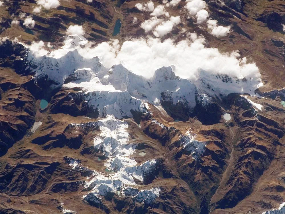
An overhead satellite image of the Cordillera Huayhuash showing mountain peaks, glaciers, alpine lakes, and cloud cover over a brown, rugged landscape.
Satellite view of the snow-capped peaks and glaciers of the Cordillera Huayhuash in the Peruvian Andes.

Cordillera Huayhuash Reserved Zone history and protected-area timeline

The Cordillera Huayhuash Reserved Zone was formally established on 20 December 2002 through Ministerial Resolution No. 1173-2002-AG, as part of Peru’s system of natural protected areas. Its creation recognized the Cordillera Huayhuash as a region of outstanding ecological, hydrological, and scenic value that warranted dedicated state-level protection rather than remaining an unprotected highland.

Following its establishment, the zone was placed under the administration of SERNANP, the national service responsible for managing Peru’s network of natural protected areas. Around the same period, four Private Conservation Areas: Huayllapa, Jirishanca, Llamac, and Pacllón, were developed as complementary privately managed areas surrounding the reserve. This constellation of public and private designations reflects a layered conservation approach in which the state-managed core zone is encircled by community and private landscape stewardship.

Before its formal protection, the Huayhuash range had already acquired international recognition through mountaineering history, particularly for routes on Yerupajá, Siula, and surrounding peaks, and through long-distance trekking circuits that traverse its valleys. The reserve’s establishment can be understood as an institutional response to the growing recognition that the range’s glacial systems, water resources, and fragile high-altitude ecosystems needed formal safeguards.

Cordillera Huayhuash Reserved Zone landscape and geographic character

The landscape of the Cordillera Huayhuash Reserved Zone is shaped by a tight, horseshoe-shaped chain of jagged Andean peaks rising above deep glacial valleys. Twenty-one snow-capped summits form the range’s spine, including the towering Yerupajá, the steep faces of Jirishanca, the pointed silhouette of Rasac, and the historically significant Siula. Between these walls, hanging valleys and high basins hold some of the most concentrated glacial scenery in Peru.

A defining feature of the terrain is its system of forty-six high-altitude glacial lakes, set into cirques and moraine basins that reflect the surrounding ice and rock. These lakes are not only visually striking but also serve as reservoirs and sediment traps, regulating the water that flows out of the range. U-shaped glacial valleys, moraines, and rugged ridgelines dominate the immediate surroundings, while the lower flanks transition into the grassy highland puna that characterizes much of the central Andes.

The reserve sits across the continental divide, so its slopes descend in two very different directions. Toward the west, valleys carry meltwater into the Pativilca and Huaura river systems, eventually reaching the Pacific coast. Toward the east, waters feed tributaries of the Marañón River, a major artery of the Amazon basin. This twin drainage means that a single storm over Huayhuash can ultimately feed both arid coastal watersheds and the vast Amazon lowlands far to the east.

Cordillera Huayhuash Reserved Zone ecosystems, habitats, and plant life

Ecologically, the Cordillera Huayhuash Reserved Zone spans a vertical gradient that compresses several Andean life zones into a relatively small area. The lowest elevations within and around the reserve support Andean grasslands and shrublands, where ichu grass and cushion plants dominate, giving way higher up to rocky puna, sparse vegetation, and eventually permanent snow and ice at the highest summits.

Wetlands associated with the forty-six glacial lakes and surrounding peatlands form important habitat nodes within this landscape. These high-altitude water bodies and their margins support specialized flora, including likely populations of cushion plants and other cold-adapted species typical of the tropical Andes, as well as aquatic and semi-aquatic vegetation around the lake edges. Glacial streams and meltwater channels further shape local plant communities by creating zones of constant moisture in otherwise exposed terrain.

The reserve’s protected status is intended to preserve these ecological gradients intact, along with the connectivity between highland habitats and the downstream forest and dry ecosystems of the Pacific and Amazonian slopes. Because the cordillera sits at the headwaters of contrasting regional biomes, the integrity of its ecosystems is ecologically significant far beyond the immediate mountain valleys.

Cordillera Huayhuash Reserved Zone wildlife and species highlights

Wildlife in the Cordillera Huayhuash Reserved Zone reflects the harsh, high-altitude character of the central Andes. High puna and polylepis woodland habitats in and around the reserve are home to camelids, particularly the vicuña and the alpaca, as well as to native Andean deer such as the taruca. Smaller mammals and a range of highland birdlife also occur in the valleys and grasslands surrounding the snow line.

Laguna systems and surrounding wetlands attract aquatic birdlife typical of the Andes, including species associated with high-altitude lakes and their margins. Raptors are common above the valleys, exploiting the strong thermal currents along the cliff faces, while smaller passerines inhabit the shrubby puna and rocky slopes below.

Because the reserve functions as a refuge of relatively undisturbed high-Andean habitat amid a heavily used landscape, its wildlife value extends beyond charismatic species. The protected area helps maintain healthy populations of native camelids and associated predators and scavengers, while its lakes and surrounding wetland complexes sustain highland bird communities that depend on these specialized aquatic habitats.

Cordillera Huayhuash Reserved Zone conservation status and protection priorities

The Cordillera Huayhuash Reserved Zone was established with the explicit purpose of safeguarding the region’s biodiversity, scenic landscapes, and water resources. Its designation recognized that the glaciers, lakes, and highland ecosystems of Huayhuash are not only locally important but also regionally critical, given that the range feeds major rivers on both sides of the Andes.

From a hydrological perspective, the reserve is a strategic conservation asset. Ice fields and glacial lakes here serve as natural reservoirs, regulating downstream flow into the Pacific-slope Pativilca and Huaura systems and into tributaries of the Marañón, ultimately influencing coastal water availability and Amazonian tributary flow. Protecting this high-altitude water storage is therefore essential for both human water security and ecological function.

A particularly distinctive feature of the conservation model around Huayhuash is the network of four surrounding Private Conservation Areas: Huayllapa, Jirishanca, Llamac, and Pacllón. Together with the state-managed reserve, they create a mosaic of formally protected landscapes that extends beyond the core zone, helping to buffer the cordillera against grazing pressure, unregulated tourism, and infrastructure development.

Cordillera Huayhuash Reserved Zone cultural meaning and human context

The Cordillera Huayhuash and the surrounding high Andes have long been part of the cultural landscape of central Peru, with traditional pastoral communities managing herds of sheep, alpacas, and llamas in the high puna around the range. Local highland communities have historically used the lower valleys as grazing territory, while the higher peaks have figured in local geography and oral tradition as powerful, sacred features of the cordillera.

In modern times, the Huayhuash range has become deeply embedded in Andean mountaineering culture and international trekking lore. Routes on Yerupajá, Siula, and other peaks have helped define the global image of technical Andean climbing, while multi-day trekking circuits around the cordillera are among the most celebrated high-mountain walks in South America. The reserve’s establishment reflects an effort to formalize protection of a landscape that already carries strong cultural and recreational meaning.

Top sights and standout views in Cordillera Huayhuash Reserved Zone

The Cordillera Huayhuash Reserved Zone stands out for the rare combination of features it concentrates within a relatively compact area: twenty-one snow-capped peaks led by Peru’s second-highest mountain, forty-six glacial lakes, and a position directly on the continental divide.

Its conservation architecture is also distinctive, pairing a state-managed core reserve with four surrounding Private Conservation Areas to form a layered network of protection. Few Peruvian protected areas share this combination of dramatic alpine scenery, ecological importance as a twin-watershed water source, and a formal multi-actor conservation mosaic.

Best time to visit Cordillera Huayhuash Reserved Zone

The character of a visit to the Cordillera Huayhuash Reserved Zone is shaped largely by the Andean dry and wet seasons. The dry season, generally running from roughly May through September, is widely associated with clearer skies, more stable weather, and easier visibility of the peaks and lakes, making it the period most often preferred for trekking and mountaineering.

The wet season brings cloudier skies and more frequent precipitation, which can obscure the high summits but also increases meltwater and runoff, swelling the glacial lakes and surrounding streams. Outside of peak mountaineering and trekking seasons, quieter periods can offer a more solitary experience of the high valleys, though conditions in the high Andes remain challenging year-round due to altitude and rapidly changing mountain weather.
Monthly climate preview

Long-term representative monthly temperature and precipitation data patterns

Cordillera Huayhuash Reserved Zone Climate Normals and Annual Weather Rhythm

Representative coordinate records show sustained thermal ranges and shifting precipitation rates across the twelve-month cycle in Cordillera Huayhuash Reserved Zone. Reviewing the complete monthly profile provides deeper analytical context on long-term regional climate behavior.
Annual mean9 °C
8 °C10 °C
Jan
Feb
Mar
Apr
May
Jun
Jul
Aug
Sep
Oct10°
Nov
Dec
Warmest month
October

9.5 °C

Coolest month
July

7.6 °C

Wettest month
February

1.5 mm/day

Driest month
August

0.2 mm/day

Park location guide

Geography guide, regional context, and park location map for Cordillera Huayhuash Reserved Zone

Cordillera Huayhuash Reserved Zone park geography, regions, and map view in Peru

Understand where Cordillera Huayhuash Reserved Zone sits in Peru through a broader geographic reading of the surrounding landscape, nearby location context, and its mapped position within the national park landscape.

How Cordillera Huayhuash Reserved Zone fits into Peru

Peru is a megadiverse country in western South America with a population of over 34 million. It spans three distinct geographic regions: the Pacific coastal desert in the west, the Andes mountains running north to south, and the Amazon rainforest in the east. The country has one of the longest histories of civilization in the world, tracing back to the Caral-Supe civilization of the 10th millennium BCE, and was home to the Inca Empire before Spanish colonization in the 16th century.

Wider geography shaping Cordillera Huayhuash Reserved Zone in Peru

Peru is located in western South America along the Pacific coast. The country encompasses three major geographic regions: the coastal desert plains along the Pacific, the Andes mountain range extending from north to southeast, and the Amazon basin rainforest in the eastern interior. It shares borders with Ecuador and Colombia to the north, Brazil to the east, Bolivia to the southeast, and Chile to the south.

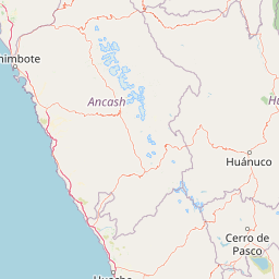
Map view of Cordillera Huayhuash Reserved Zone

Use this park location map to pinpoint Cordillera Huayhuash Reserved Zone in Peru, understand its exact geographic position, and read its mapped placement within the surrounding landscape more clearly.

Pigeon | © OpenStreetMap contributors

Location context for Cordillera Huayhuash Reserved Zone

Ancash RegionHuánuco RegionLima Region
Recorded earthquake history

Explore Recorded Earthquake History for the Cordillera Huayhuash Reserved Zone

Access a structured collection of recorded seismic events associated with the Cordillera Huayhuash Reserved Zone. MoriAtlas provides this catalogue to support geographic understanding of historical activity in this high-altitude Andean protected area through clear, mapped, and filterable data.

Cordillera Huayhuash Reserved Zone Earthquake History

Catalogued events

19 events

Strongest magnitude

Magnitude 4.9

Most recent event

Feb 18, 2025

This history includes earthquakes recorded inside the park or within 50 km of its borders

Visualizing high-altitude Andean peaks, glacial lakes, and protected terrain

Cordillera Huayhuash Reserved Zone Photos, Landscape, and Scenery Explorer

Visual records capture the rugged topography of jagged snow-capped summits, turquoise glacial lakes, and steep alpine valleys defining the protected reserve. Examining photographic evidence reveals the dramatic vertical relief, high-altitude habitats, and stark environmental character of the central Andean cordillera.

An overhead satellite image of the Cordillera Huayhuash showing mountain peaks, glaciers, alpine lakes, and cloud cover over a brown, rugged landscape.

Park atlas

Compare adjacent protected landscapes, high altitude terrain, and regional Andean geography.

Exploring Parks Near Cordillera Huayhuash Reserved Zone and Surrounding Andean Reserves

Compare adjacent high altitude protected areas and regional mountain reserves located near Cordillera Huayhuash Reserved Zone. Expanding geographic research across surrounding Andean landscapes provides deeper context on regional topography and connected ecosystems.
National parkAncash
26 km away#1 closest

Northwest

Huascarán National Park: Protected Landscape and Regional Geography in Ancash, Peru

Explore the mapped boundaries of this significant national park.

Huascarán National Park is a protected national park located in the Ancash region of Peru, offering valuable insights for geographic and atlas exploration. This destination provides detailed information on the park's mapped boundaries, its designation as a national park, and its integration into the regional geography. Understanding Huascarán National Park helps contextualize protected land distribution and landscape features within Peru for those interested in structured geographic discovery and atlas-style mapping.

Area
3,400 km²
Established
1975
IUCN
II
Relief
Mountain
National parkPasco Region
118 km away#2 closest

East

Yanachaga, Chemillén National Park: Protected Area in Pasco Region, Peru

Mapped terrain, Pleistocene refuge, and rich biodiversity.

Yanachaga, Chemillén National Park, a national park situated in Peru's Pasco Region, preserves over 122,000 hectares of mountainous cloud forest and rainforest ecosystems. Its landscape is characterized by dramatic canyons and steep forested slopes, creating significant altitudinal variation from 460 to 3,643 meters. Recognized as a Pleistocene refuge, the park shelters ancient forest remnants and harbors exceptional biodiversity, including hundreds of bird species and iconic mammals, offering rich context for geographic and protected-area exploration.

Area
1,220 km²
Established
1986
IUCN
II
Relief
Mountain
National parkHuánuco Region
127 km away#3 closest

Northeast

Tingo María National Park: National Park Protected Landscape in Huánuco Region, Peru

Atlas exploration of park boundaries and regional geography.

Investigate Tingo María National Park, a key protected area situated in the Huánuco Region of Peru. This national park designation signifies its importance for understanding the country's natural landscapes and mapped geography. Explore its protected territory and discover its place within the regional atlas.

Area
47.778 km²
Established
1965
IUCN
II
Relief
Mountain
Nature reserveLima Region
About 138 km away#4 closest

South

Ancón Reserved Zone: Protected Coastal Desert and Bay Ecosystems in Lima Region

Coastal desert landscapes and marine habitat protection

The Ancón Reserved Zone represents a key protected area where the dry coastal plains of Peru reach the Pacific Ocean. Its mapped boundaries encompass a critical transition zone between arid desert terrain and marine environments, offering a concentrated look at specialized regional ecology within the Lima Province.

Area
21.93 km²
Established
2013
Relief
Lowland
Climate
Arid
Protected areaOxapampa Province
142 km away#5 closest

East

Yanesha Communal Reserve: Geography and Protected Area Context in Oxapampa Province

A vital transition zone between the Andes and the Amazon

Gain insight into the physical character of Yanesha Communal Reserve, where humid tropical forests and river channels converge to form a complex ecosystem. This protected area offers a look at how sustainable land use and conservation intersect within the Palcazu River basin. Browse the geographic boundaries and mapped landscape features that define this essential region in central Peru.

Area
347.45 km²
Established
1988
IUCN
VI
Scope
Terrestrial
A horizontal watercolor illustration depicting rolling green hills and foreground vegetation on a white background.
Nature reserveLima Region
156 km away#6 closest

South

Bosque de Zárate Reserved Zone: Mapped Geography and Protected Landscape Analysis

Andean fog forest terrain within the Lima Region

Bosque de Zárate Reserved Zone provides a distinct look at the transition from arid western Andean slopes to lush mist forests. The reserve preserves critical habitat for endemic bird species and stabilizes vital gorge terrain along the San Bartolomé River, serving as a model for protected landscapes in central Peru.

Area
5.46 km²
Established
2010
Water
Minor water
A horizontal watercolor painting showing rolling green hills and pinkish ground vegetation under a soft, light-yellow sky.
Protected areaPasco Region
166 km away#7 closest

East

San Matías, San Carlos Protection Forest: Geographic Boundaries and Protected Landscape Context

A vital watershed corridor in the Pasco Region of central Peru.

San Matías, San Carlos Protection Forest protects fragile mountain soils and downstream infrastructure from erosion and flooding. Stretching from 300 to 2,250 metres in elevation, the reserve supports a continuous block of highland habitat that serves as a bridge between the Peruvian Yungas and Ucayali moist forest ecoregions, while acting as a cornerstone of the Oxapampa-Asháninka-Yánesha Biosphere Reserve.

Area
1,458 km²
Established
1987
IUCN
VI
Relief
Mountain
National parkPeru
170 km away#8 closest

North

Cordillera Azul National Park: A National Park for Geographic Discovery in Peru

Explore Peru's protected landscape and regional map context.

Cordillera Azul National Park serves as a dedicated entry point for understanding Peru's protected natural areas through a geographic lens. This park's identity is tied to its specific mapped boundaries and its contribution to the nation's diverse terrain. Focusing on Cordillera Azul National Park allows for detailed atlas exploration of its unique landscape context within western South America, providing factual data for geographic understanding.

Area
13,531.9 km²
Established
2001
IUCN
II
Relief
Mountain

Common questions about visiting, size, designation, and location context for Cordillera Huayhuash Reserved Zone

Cordillera Huayhuash Reserved Zone FAQs for park facts, access, geography, and protected area context

Find quick answers about Cordillera Huayhuash Reserved Zone, including protected-area facts, park geography, trail and visitor context, and how the park fits into its surrounding country and regional landscape.
MoriAtlas Explorer

Continue Your Protected Areas Search Across the Global Atlas

Deepen your exploration by continuing the structured search for national parks and protected areas worldwide. Utilize the comprehensive filtering capabilities to compare different conservation landscapes and refine your understanding of global park geography. Discover more about the distribution and characteristics of protected natural areas.

Global natural geography
