

Mori Atlas logo
National parkCrab Replenishment Reserve

Discover the mapped boundaries and regional geography of this national park in Andros

Crab Replenishment Reserve National Park: Protected Landscape & Geographic Context

The Crab Replenishment Reserve National Park represents a key protected area within the archipelago's geographic atlas. Situated in Andros, this park offers a unique opportunity to explore mapped natural landscapes and understand its role as a conservation territory. Users can investigate the park's boundaries, its regional setting, and the specific geographic features that define this important national park designation.

National ParkProtected AreaBahamasAndros IslandLand Crab HabitatCoastal Ecosystem

Crab Replenishment Reserve

National park

Park overview

Structured park overview, official facts, and landscape profile for Crab Replenishment Reserve

Crab Replenishment Reserve park facts, protected area profile, and essential visitor context
Review the core facts for Crab Replenishment Reserve, including designation, size, terrain, visitor scale, habitats, and operating context in one park-focused overview.

About Crab Replenishment Reserve

Crab Replenishment Reserve occupies a meaningful place within the Bahamas' system of protected areas. The park was established in 2002 as part of the Bahamas National Trust's ongoing efforts to preserve the nation's natural heritage. Andros Island, where the reserve is located, is the largest island in the Bahamas and features a diverse landscape that includes extensive wetlands, pine forests, and coastal ecosystems. The reserve's establishment reflected growing recognition of the need to protect critical habitats within this island chain. Managed by the Bahamas National Trust, the park contributes to the broader network of protected areas that help maintain ecological balance throughout the archipelago.

Quick facts and research context for Crab Replenishment Reserve

Crab Replenishment Reserve is a 4,000-acre national park on Andros Island in the Bahamas, established in 2002 and managed by the Bahamas National Trust. The reserve is categorized as IUCN Protected Area Management Type II, the same classification used for national parks worldwide. It lies within the Bahamas archipelago, a chain of more than 700 islands and cays stretching southeast from Florida. The park's central conservation purpose centers on protecting land crab populations and their habitats.

Park context

Deeper park guide and search-rich context for Crab Replenishment Reserve

Crab Replenishment Reserve history, landscape, wildlife, and travel context
Explore Crab Replenishment Reserve through its history, landscape character, ecosystems, wildlife, conservation priorities, cultural context, and seasonal travel timing in a structured park guide built for atlas discovery and search intent.

Why Crab Replenishment Reserve stands out

The Crab Replenishment Reserve is specifically recognized for its role in protecting land crab populations and their natural habitats. Land crabs are a distinctive component of Bahamian ecology, and this reserve was created with the explicit purpose of ensuring sustainable populations of these crustaceans. The park represents a targeted conservation approach, focusing on a single ecologically important species rather than broader biodiversity protection.

Crab Replenishment Reserve history and protected-area timeline

The Crab Replenishment Reserve was established in 2002 as a national park under the management of the Bahamas National Trust, the primary conservation organization responsible for managing protected areas throughout the Bahamas. The creation of this reserve reflected a conservation priority focused on land crabs, which have traditionally been a significant part of the Bahamian natural environment. The establishment of the park in 2002 placed it among the more recently designated protected areas in the Bahamas National Park system, which has grown progressively since the first parks were created in the 1950s and 1960s.

Crab Replenishment Reserve landscape and geographic character

Andros Island features a distinctive landscape characterized by vast mangrove swamps, pine forests, and complex coastal ecosystems. The terrain is generally low-lying, with extensive wetlands and tidal areas that create important ecological interfaces between terrestrial and marine environments. The island's western coastline faces the Tongue of the Ocean, a deep oceanic trench that contributes to the ecological diversity of the region. Within this setting, the Crab Replenishment Reserve encompasses habitats that support land crab populations, typically including forested areas and transitional zones between inland and coastal environments.

Crab Replenishment Reserve ecosystems, habitats, and plant life

The reserve protects habitats that are essential for land crab survival and reproduction. Land crabs in the Bahamas occupy ecological niches that bridge terrestrial and coastal environments, and their populations depend on protected areas that provide suitable conditions. The broader Andros environment includes pine rockland habitats, wetlands, and coastal mangroves that together form a complex ecological system. While the Wikipedia source specifically mentions land crabs as the focal species, the reserve's habitats likely support additional species associated with the island's diverse ecosystems.

Crab Replenishment Reserve wildlife and species highlights

The park is specifically noted for providing habitat for land crabs, which are a notable component of Bahamian fauna. Land crabs are crustaceans that have adapted to terrestrial life in tropical island environments, and they play roles in nutrient cycling and soil aeration within their ecosystems. The reserve's protected status helps ensure that these populations can maintain healthy numbers without the pressures that might otherwise threaten their survival.

Crab Replenishment Reserve conservation status and protection priorities

The Crab Replenishment Reserve represents a species-focused conservation approach within the Bahamas' protected area network. By establishing a dedicated reserve for land crab protection, the Bahamas National Trust acknowledged the ecological importance of these crustaceans and the need for targeted habitat preservation. The park contributes to the broader conservation framework that includes multiple national parks and marine protected areas throughout the Bahamas archipelago, working together to preserve the nation's natural diversity.

Crab Replenishment Reserve cultural meaning and human context

The reserve exists within the context of Andros Island, which has a long human history intertwined with the natural environment. The Bahamas National Trust, as the managing authority, operates within a national framework that recognizes the importance of balancing environmental protection with sustainable use of natural resources. The reserve's name reflects a particular focus on resource replenishment, suggesting historical concerns about land crab populations and their sustainability.

Top sights and standout views in Crab Replenishment Reserve

The Crab Replenishment Reserve stands out as a specifically designated protected area focused on land crab conservation on Andros, the largest island in the Bahamas. Established in 2002, it represents a targeted approach to protecting a species of particular ecological significance to the Bahamas. The reserve is part of the Bahamas National Trust's portfolio of protected areas and contributes to the nation's overall conservation objectives.

Best time to visit Crab Replenishment Reserve

The Bahamas experiences a subtropical climate with warm temperatures year-round. The most comfortable period for outdoor exploration typically occurs during the cooler winter months from November through April, when temperatures are milder and humidity is reduced. The summer months from May through October tend to be warmer and wetter, with increased humidity and the possibility of tropical storms. Visitors interested in observing land crabs and exploring the reserve's habitats should consider the seasonal patterns that affect both weather conditions and wildlife activity levels.
Park location guide

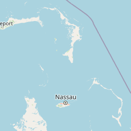
Geography guide, regional context, and park location map for Crab Replenishment Reserve

Crab Replenishment Reserve park geography, regions, and map view in Bahamas
Understand where Crab Replenishment Reserve sits in Bahamas through a broader geographic reading of the surrounding landscape, nearby location context, and its mapped position within the national park landscape.

How Crab Replenishment Reserve fits into Bahamas

The Bahamas is an island nation in the Atlantic Ocean, forming part of the Lucayan Archipelago. It consists of more than 3,000 islands, cays and islets located north of Cuba, northwest of Hispaniola, and southeast of Florida. The country gained independence from Britain in 1973 and operates as a constitutional monarchy under King Charles III, with Nassau as its capital and largest city.

Wider geography shaping Crab Replenishment Reserve in Bahamas

The Bahamas occupies the Lucayan Archipelago in the Atlantic Ocean. The island chain is positioned north of Cuba, northwest of Hispaniola (shared by the Dominican Republic and Haiti), southeast of the US state of Florida, and east of the Florida Keys. The territory spans over 3,000 islands, cays and islets, with the total land area being 13,943 km². The Royal Bahamas Defence Force claims approximately 470,000 km² of surrounding ocean space.

Map view of Crab Replenishment Reserve

Use this park location map to pinpoint Crab Replenishment Reserve in Bahamas, understand its exact geographic position, and read its mapped placement within the surrounding landscape more clearly.

Pigeon | © OpenStreetMap contributors

Location context for Crab Replenishment Reserve

Andros
Park atlas

Explore the Diverse Protected Landscapes and Regional Geography of Andros Island and the Bahamas

Discover Related National Parks and Protected Areas Near Crab Replenishment Reserve
Explore national parks and protected areas near Crab Replenishment Reserve, uncovering the diverse coastal ecosystems and wetland habitats of Andros Island and the broader Bahamas archipelago. Compare different conservation landscapes, understand regional protected area geography, and trace the spread of unique Bahamian environments beyond this specific crab habitat.
National parkAndros

Blue Holes National Park: A National Park for Detailed Geographic and Landscape Exploration

Explore mapped boundaries and regional terrain context.

Delve into the specifics of Blue Holes National Park, a designated national park offering rich opportunities for geographic discovery. This entry provides structured information focused on its protected landscape identity, mapped outlines, and its contribution to the regional geography of Andros, Bahamas. Understand the park's unique setting through detailed map context and atlas-driven insights.

Area
162 km²
Established
2002
IUCN
II
Relief
Mixed relief
National parkBahamas

North and South Marine Parks National Park: Geographic Atlas and Protected Landscape in the Bahamas

Mapping Bahamian protected marine geography and its national park boundaries.

Delve into the atlas-view of North and South Marine Parks, a key national park in the Bahamas. This page details the park's specific geographic features and its protected landscape identity within the island nation. Understand its placement and significance as a protected marine area contributing to the regional geography.

Area
20 km²
Established
2002
IUCN
II
Climate
Tropical
National parkBahamas

West Side National Park National Park: Extensive Protected Landscape in the Bahamas

Mapped marine and mangrove ecosystems, plus pine forest terrain

Delve into the geographical identity of West Side National Park, a protected national park in the Bahamas renowned for its vast scale and diverse ecosystems. This landscape features significant Caribbean pine forests transitioning into extensive, intact mangrove systems along its coastlines, integrating directly with vital marine habitats. As one of the largest protected areas in the Caribbean, its ecological representation from land to sea offers a unique atlas perspective on Bahamian natural heritage and conservation.

Area
6,070 km²
Established
2002
IUCN
II
Relief
Mixed relief
National parkBahamas

Primeval Forest National Park: A Protected Landscape within the Bahamas Archipelago

Explore mapped boundaries and regional geography in the Lucayan Archipelago.

Primeval Forest National Park serves as a key protected area within the Bahamas, offering a focused view of island geography and conservation landscapes. This national park is a critical element for understanding the archipelago's natural terrain and mapped protected lands. Its presence provides valuable geographic context, allowing for detailed exploration of its boundaries and its place within the broader Bahamian atlas.

Established
2002
Relief
Mixed relief
Climate
Tropical
Access
Easy access
National parkBahamas

Bonefish Pond National Park: Essential Bahamas Coastal Wetland & Marine Nursery

Mapped protected area, mangrove ecosystem, and habitat for key marine species.

Bonefish Pond National Park, a protected national park on New Providence island in The Bahamas, is essential for its role as a thriving marine nursery. The park's landscape features extensive red mangrove forests, tidal channels, and shallow lagoons crucial for juvenile bonefish, crawfish, and conch. This area highlights effective wetland restoration and conservation, offering valuable insights into Caribbean coastal protected landscapes and their geographic importance.

Area
5 km²
Established
2002
IUCN
II
Relief
Lowland
National parkBahamas

Exuma Cays Land and Sea Park National Park: Mapped Protected Landscape in the Bahamas

Explore its geographic identity and atlas context.

This page provides detailed map-based information on Exuma Cays Land and Sea Park, a significant national park located in the Bahamas. Discover its protected area boundaries, explore its unique geographic setting within the archipelago, and understand its role as a key natural landscape. The content is geared towards atlas exploration, offering a factual overview of the park's spatial and regional importance without any visitor logistics or operational details.

Area
455.84 km²
Established
1959
Relief
Lowland
Climate
Tropical
National parkSouth Abaco

Abaco National Park: Bahamian National Park with Mapped Protected Landscape

Explore its geographic setting and protected area boundaries.

Abaco National Park stands as a designated national park within the Bahamas, contributing to the conservation of its unique protected landscapes. This entry provides detailed insights into its geographic positioning in South Abaco, focusing on the mapped extent of its protected area and its broader regional landscape context for atlas exploration.

Area
83 km²
Established
1994
Climate
Tropical
Scope
Terrestrial
National parkBahamas

Pelican Cays Land and Sea Park: Protected Marine Landscape in the Bahamas

Explore coral reefs, undersea caves, and vital sea turtle habitats.

Pelican Cays Land and Sea Park, a protected national park in the Bahamas, offers a rich marine atlas experience. Its landscape is defined by extensive coral reef formations and unique undersea cave systems, supporting remarkable biodiversity. This park highlights the importance of protected waters for species like sea turtles and provides exceptional opportunities for exploring submerged geography and vibrant coral ecosystems.

Area
8 km²
Established
1972
IUCN
II
Relief
Lowland

Common questions about visiting, size, designation, and location context for Crab Replenishment Reserve

Crab Replenishment Reserve FAQs for park facts, access, geography, and protected area context
Find quick answers about Crab Replenishment Reserve, including protected-area facts, park geography, trail and visitor context, and how the park fits into its surrounding country and regional landscape.
MoriAtlas Explorer

Continue Your Protected Areas Search Across the Global Atlas

Deepen your exploration by continuing the structured search for national parks and protected areas worldwide. Utilize the comprehensive filtering capabilities to compare different conservation landscapes and refine your understanding of global park geography. Discover more about the distribution and characteristics of protected natural areas.

Global natural geography