
Mori Atlas logo
Nature reserveCuxhavener Küstenheiden

A protected mosaic of sand dunes and wet heaths along the Lower Saxony North Sea coast

Cuxhavener Küstenheiden Nature Reserve: Coastal Heathland Landscapes and Regional Geography

(Naturschutzgebiet Cuxhavener Küstenheiden)

The Cuxhavener Küstenheiden represents one of the most coherent coastal heath landscapes in Germany, where the sandy Stader Geest transitions into the dynamic tidal environment of the Wadden Sea. This nature reserve serves as a critical protected area, containing a diverse habitat mosaic of crowberry heath, open sand dunes, woodland fringes, and wet depressions. By maintaining these threatened environments through grazing, the site preserves a rare ecological corridor within the broader geography of Lower Saxony.

coastal heathduneswet heathgravel and sandy soilsWadden Sea transitionNatura 2000
A flat vector illustration of a coastal heathland landscape with evergreen trees, shrubs, and a golden sun in the sky.

Cuxhavener Küstenheiden

Nature reserve

Park overview

Structured park overview, official facts, and landscape profile for Cuxhavener Küstenheiden

Cuxhavener Küstenheiden park facts, protected area profile, and essential visitor context

Review the core facts for Cuxhavener Küstenheiden, including designation, size, terrain, visitor scale, habitats, and operating context in one park-focused overview.

About Cuxhavener Küstenheiden

The Cuxhavener Küstenheiden lies within the municipal territory of Cuxhaven in the German state of Lower Saxony, extending across the districts of Altenwalde, Berensch-Arensch, Duhnen, Holte-Spangen, Oxstedt, and Sahlenburg. Geographically the reserve sits on the Stader Geest, the sandy geest landscape north of the Elbe, at the point where it narrows and slopes down toward the mudflats of the Wadden Sea. This position on the edge of the geest defines much of the area's identity and ecological character.

In administrative terms the reserve, designated as NSG LÜ 267, consists of one larger main area and three smaller separate sections. It was first protected in 1983 and is now administered by DBU Naturerbe, while the Niedersächsischer Landesbetrieb für Wasserwirtschaft, Küsten- und Naturschutz (NLWKN) remains a key agency involved in its oversight. About 781 hectares are simultaneously recognized as a European Fauna-Flora-Habitat (FFH) site, integrating the area into the broader European network of protected habitats.

Ecologically the Cuxhavener Küstenheiden is defined by a mosaic of habitat types that is unusually well preserved along this stretch of coast. Crowberry heath, dry sand heaths, wet heaths, open sandy surfaces, and dunes form the core of the open landscape, while woodland patches, scrub transitions, small water bodies, and extensive wet grassland add structural diversity. Together these habitats support a rich community of specialized coastal and heathland species and give the reserve a layered, fragmented character that is ecologically and visually distinctive.

Conservation management is central to the reserve. Large grazing animals, including wisent (European bison), Konik horses, and Heck cattle, are used to maintain the open heath, mimicking historic land-use patterns and helping slow the spread of woody encroachment. At the same time, conservationists face an ongoing challenge from the rapid spread of the late-flowering cherry, a neophytic tree from North America that, if left unchecked, would gradually convert open heath into closed woodland. The combination of active grazing, targeted habitat management, and Natura 2000 integration has made the Cuxhavener Küstenheiden one of the reference sites for coastal heath conservation in northern Germany.

Quick facts and research context for Cuxhavener Küstenheiden

The Cuxhavener Küstenheiden is a nature reserve (Naturschutzgebiet) in Lower Saxony, located on the outskirts of Altenwalde and Sahlenburg near the city of Cuxhaven. It belongs to the natural region of the Stader Geest and forms the transition zone from the older sandy uplands to the Wadden Sea. Covering roughly 892 hectares across multiple municipal areas, it has been a formally protected landscape since the late twentieth century and now also forms part of an EU Habitats Directive site for coastal heath and kratt woodland.

The reserve is notable for its unusually intact coastal heath and is managed as an IUCN Category IV Habitat/Species Management Area. Grazing animals such as wisent, Konik horses, and Heck cattle help maintain the open heath structure, while 781 hectares of the area are simultaneously designated as a Natura 2000 site.

Protection and recognition

Documented terrestrial protection scope, designation year, and recognition sources

Cuxhavener Küstenheiden Protection Status and Official Designation History

Cuxhavener Küstenheiden holds a documented terrestrial protection status established in 2004 within the global database registry. Official records track designation history and management scope for this protected area without external recognition sources.

Protection details

Protection scope
Terrestrial
Designated year
2004
Transboundary protection
No
WDPA ID
329318
Park context

Deeper park guide and search-rich context for Cuxhavener Küstenheiden

Cuxhavener Küstenheiden history, landscape, wildlife, and travel context

Explore Cuxhavener Küstenheiden through its history, landscape character, ecosystems, wildlife, conservation priorities, cultural context, and seasonal travel timing in a structured park guide built for atlas discovery and search intent.

Why Cuxhavener Küstenheiden stands out

The reserve is best known for its exceptional scale of intact coastal heath along the German North Sea coast, a habitat type that has become rare and fragmented elsewhere. Its mosaic of dry sand heath, wet heath, crowberry heath, open sand patches, dunes, and small wetlands creates one of the most complete coastal heath landscapes in Germany. The reserve is also recognized for combining this historic heath landscape with active conservation management, particularly the use of large grazing animals to keep the open habitats free of encroaching scrub and invasive species like the late-flowering cherry, which has been spreading rapidly through parts of the heath.
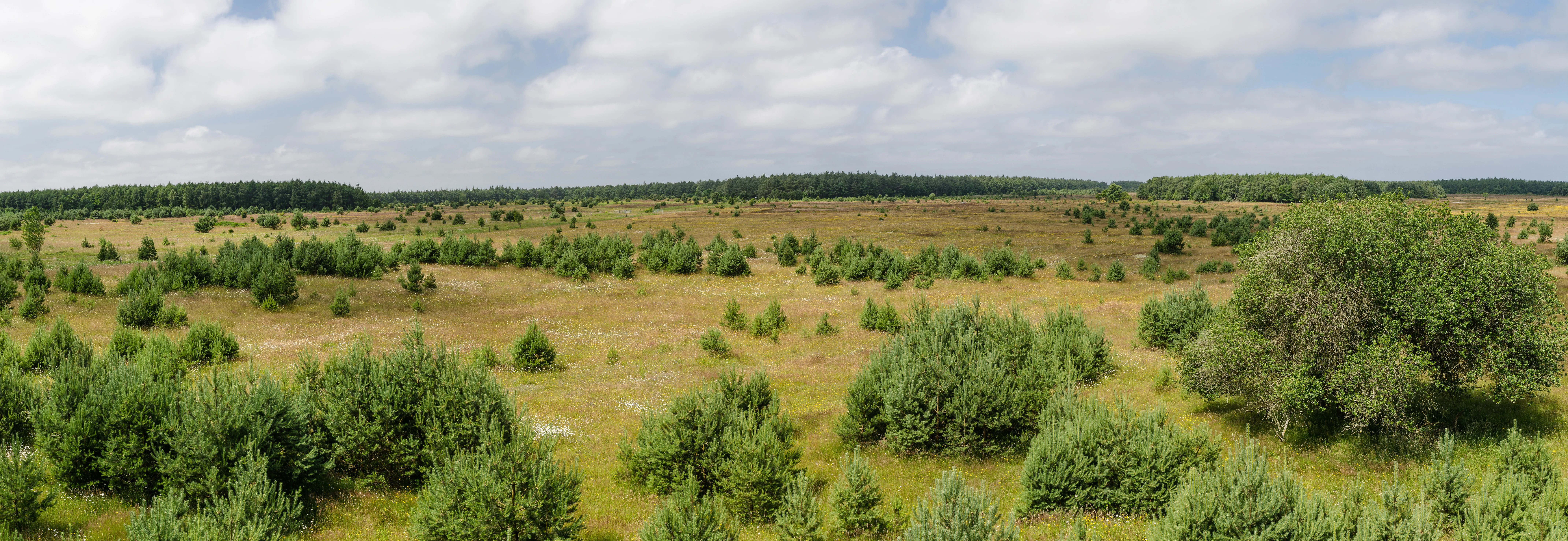
A wide-angle panoramic view of a flat coastal heathland with scattered small pine trees and low shrubs under a cloudy sky.
A panoramic view of the heathland landscape in Cuxhavener Küstenheiden.

Cuxhavener Küstenheiden history and protected-area timeline

The Cuxhavener Küstenheiden were formally designated as a nature reserve on 31 May 1983 by the former Bezirksregierung Lüneburg, placing the area's long-standing coastal heath under modern legal protection. The current Schutzgebietsverordnung, the legal ordinance governing the reserve, dates from 6 December 2004 and, together with the original designation, replaced earlier and more narrowly defined protected areas such as the Sahlenburger Steertmoor and the Spangener Heide.

Following the 2004 ordinance, operational management of the reserve was taken over by DBU Naturerbe, the nature heritage branch of the Deutsche Bundesstiftung Umwelt, marking a shift toward heritage-based large-area conservation. The reserve's integration into the European Natura 2000 network, through the FFH site known as "Küstenheide und Krattwälder bei Cuxhaven," reflects its recognition as a habitat of European importance and anchored it within transnational conservation frameworks.

Cuxhavener Küstenheiden landscape and geographic character

The landscape of the Cuxhavener Küstenheiden is shaped by the meeting of two very different terrains: the older, sandy Stader Geest inland and the younger, dynamic tidal flats of the North Sea just beyond. This transitional setting produces a varied coastal scenery in which dunes, open sand, low heath, brushy woodland fringes, and wet depressions all lie within a short distance of each other.

Much of the terrain consists of gently undulating sandy soils, dotted with dry heath ridges, dune-like mounds, and shallow wet hollows. The reserve's structure is intentionally fragmented, with one larger continuous block and several smaller satellite areas, mirroring the patchwork of historic land use along this stretch of coast. Small open water bodies and wet meadows add further texture to the otherwise predominantly dry, sandy environment.

Cuxhavener Küstenheiden ecosystems, habitats, and plant life

The natural value of the Cuxhavener Küstenheiden rests on its unusually intact mosaic of coastal heath habitats. Crowberry heath, dry sand heaths, and wet heaths each represent different stages and moisture regimes of this once widespread North Sea coastal landscape. Open sand patches and active dune areas add pioneer habitats, while the surrounding kratt woodland, a local term for coppice-like oak woodland, and patches of wet grassland create ecological edge zones between dry and wet environments.

The reserve also contains small standing waters and wet depressions that support moisture-loving plant communities, including rare species such as the marsh gentian, the round-leaved sundew, and the thread sedge. Together these habitats form one of the largest coherent complexes of coastal heath still in existence in Germany, making the area ecologically significant far beyond its local context.

Cuxhavener Küstenheiden wildlife and species highlights

The reserve provides habitat for more than two hundred threatened animal and plant species, reflecting the unusually high ecological density of this relatively small coastal area. Birdlife is a particular highlight, with heathland and ground-nesting species such as the northern wheatear, grey partridge, whinchat, and European stonechat all regular breeders or visitors in the open heath and dune areas.

Reptiles and amphibians are well represented, including the sand lizard as a notable reptile species and the moor frog as a threatened amphibian. The reserve's small wet areas and pools also support a rich dragonfly assemblage, including the large whiteface, a rare dragonfly that depends on the open, acidic wet habitats typical of coastal heath. The combination of open sand, low heath, scrub edges, wet meadows, and small waters creates the layered habitat structure these very different species groups depend on.

Cuxhavener Küstenheiden conservation status and protection priorities

As an IUCN Category IV Habitat/Species Management Area, the Cuxhavener Küstenheiden is explicitly managed to maintain and improve specific habitats and species rather than left as a purely untouched reserve. Its combination of national nature reserve status and European FFH designation gives it overlapping layers of protection, ensuring that the coastal heath, dunes, kratt woodland, and wet grassland complexes are monitored both nationally and within the Natura 2000 framework.

Conservation management centers on preserving the open character of the heath. Wisent, Konik horses, and Heck cattle graze large sections of the reserve to prevent the gradual conversion of open heath into closed woodland. This grazing mimics historic land use and helps keep invasive and aggressive woody species, most notably the late-flowering cherry, in check. The reserve also serves as a reference area for coastal heath conservation in Germany, where similar habitats have been largely lost to agriculture, afforestation, or development.

Cuxhavener Küstenheiden cultural meaning and human context

The Cuxhavener Küstenheiden are deeply rooted in the traditional coastal land-use patterns of the Lower Saxony North Sea coast. Heath landscapes like these were historically shaped by grazing, turf cutting, and small-scale agriculture, practices that left behind the open sandy heaths and scattered woodland patches now recognized as ecologically valuable.

Today the reserve continues this cultural-natural link through the deliberate use of hardy, semi-wild grazing breeds, including Heck cattle, Konik horses, and wisent. These animals echo the historic role of livestock in shaping the heath while serving as a living bridge between the cultural landscape of the past and the conservation goals of the present. The reserve's location within the city of Cuxhaven also means it functions as a closely held local natural landmark, valued both as ecological heritage and as part of regional identity.

Top sights and standout views in Cuxhavener Küstenheiden

Among the reserve's most distinctive qualities is the sheer scale and coherence of its coastal heath, widely regarded as unique in Germany for its combination of size and ecological integrity. The integration of dry heath, wet heath, dunes, scrub, woodland, and small aquatic habitats within a single reserve creates an unusually rich habitat mosaic.

Equally notable is the reserve's grazing-based conservation approach, which uses wisent, Konik horses, and Heck cattle to maintain open heath landscapes and counteract the encroachment of the invasive late-flowering cherry. Layered national and European protections, along with administration by DBU Naturerbe, further underscore the area's standing as one of the benchmark sites for coastal heath conservation along the German Wadden Sea coast.

Best time to visit Cuxhavener Küstenheiden

Late spring through early autumn is generally the most rewarding period to experience the Cuxhavener Küstenheiden, when the heath is in bloom, ground-nesting birds are active, and grazing animals are most visible across the open landscape. Summer brings the fullest display of heathland flowering and dragonfly activity around the reserve's small ponds and wet areas.

Autumn can also appeal to visitors, with softer light over the heath and waders and waterfowl beginning to gather along the nearby Wadden Sea coast. Winter visits are quieter and can highlight the bare structure of the dunes, scrub, and woodland edges, though weather conditions along the exposed North Sea coast can be harsh.


Monthly climate preview

Trace twelve-month temperature averages and precipitation rhythms across representative coordinate data

Cuxhavener Küstenheiden Climate Normals and Annual Weather Patterns

Representative point records from 1991 to 2020 outline the measured long-term temperature progression and monthly precipitation rates for Cuxhavener Küstenheiden. Accessing the complete twelve-month climatology profile allows detailed comparison of seasonal minimum and maximum temperature variations.
Annual mean10 °C
2 °C18 °C
Jan
Feb
Mar
Apr
May12°
Jun15°
Jul18°
Aug18°
Sep15°
Oct11°
Nov
Dec
Warmest month
August

17.9 °C

Coolest month
January

2.2 °C

Wettest month
December

2.7 mm/day

Driest month
April

1.4 mm/day

Park location guide

Geography guide, regional context, and park location map for Cuxhavener Küstenheiden

Cuxhavener Küstenheiden park geography, regions, and map view in Germany

Understand where Cuxhavener Küstenheiden sits in Germany through a broader geographic reading of the surrounding landscape, nearby location context, and its mapped position within the national park landscape.

How Cuxhavener Küstenheiden fits into Germany

Germany is a federal republic in Western and Central Europe with a population of over 83 million across sixteen constituent states. It is Europe's largest economy by nominal GDP and a major global exporter and importer. The capital is Berlin, and the country borders Denmark, Poland, Czech Republic, Austria, Switzerland, France, Luxembourg, Belgium, and the Netherlands.

Wider geography shaping Cuxhavener Küstenheiden in Germany

Germany is located in Western and Central Europe, spanning 357,022 km². It borders Denmark to the north, Poland and the Czech Republic to the east, Austria and Switzerland to the south, and France, Luxembourg, Belgium, and the Netherlands to the west. The country has coastlines on the Baltic Sea and North Sea to the north, with the Alps located in the southern region.

Map view of Cuxhavener Küstenheiden

Use this park location map to pinpoint Cuxhavener Küstenheiden in Germany, understand its exact geographic position, and read its mapped placement within the surrounding landscape more clearly.

Pigeon | © OpenStreetMap contributors

Location context for Cuxhavener Küstenheiden

Lower Saxony

Explore detailed imagery of dunes, sandy soils, and rare protected habitats along the North Sea coast

Cuxhavener Küstenheiden Photos and Landscapes: Visualizing Coastal Heath Scenery

Visual documentation of Cuxhavener Küstenheiden reveals the intricate mosaic of dry sand heaths, wet hollows, and coastal dunes that define the northern terrain. Studying these protected-area photographs provides deeper insight into the rare ecological transition where sandy inland soils meet dynamic tidal ecosystems.

A wide-angle panoramic view of a flat coastal heathland with scattered small pine trees and low shrubs under a cloudy sky.

A sandy trail winds through a coastal heathland field filled with purple blooming heather bushes under a bright sky.

Park atlas

Compare regional park geography and adjacent protected landscapes

Parks Near Cuxhavener Küstenheiden and Surrounding Coastal Protected Areas

Explore other protected areas near Cuxhavener Küstenheiden to examine related coastal ecosystems and regional terrain. Continued comparison reveals broader habitat patterns across adjacent northern lowland reserves.
Watercolor painting showing coastal wetlands with mudflats, salt marshes, and distant hills under a soft light
National parkLower Saxony
About 3.3 km away#1 closest

West

Lower Saxon Wadden Sea National Park: Protected Coastal Landscape & Geography Atlas

Explore mapped boundaries, intertidal zones, and Lower Saxony's natural terrain.

Delve into the Lower Saxon Wadden Sea National Park, a significant national park situated in Lower Saxony, Germany. This page serves as your atlas entry point for understanding its protected landscape, characterized by vast mudflats, salt marshes, and a crucial role as a migratory bird corridor. Discover the geographic context of this UNESCO World Heritage site and its unique intertidal ecosystem through structured map data and detailed landscape information.

Area
345.8 km²
Established
1986
IUCN
II
Relief
Lowland
Watercolor painting of a landscape with a winding river, green hills, and scattered vegetation under a pale sky
National parkHamburg
About 4.5 km away#2 closest

Northwest

Hamburg Wadden Sea National Park: North Sea Tidal Landscape and Protected Area

Explore the mapped geography of this unique coastal national park.

Hamburg Wadden Sea National Park, a vital part of the UNESCO-listed Wadden Sea, showcases a unique dynamic landscape of intertidal mudflats, sandbars, and dune islands. This protected national park provides critical habitat for numerous bird species and marine mammals, offering an unparalleled opportunity to study tidal ecosystem dynamics and coastal geography through detailed mapping and atlas exploration.

Area
137.5 km²
Established
1990
IUCN
II
Relief
Lowland
Nature reserveLower Saxony
About 9.4 km away#3 closest

Southeast

Wanhödener Moor Nature Reserve: Mapping Bog Ecology in Lower Saxony, Germany

Protected raised bog and coastal wetland landscapes

Located in the district of Cuxhaven, Wanhödener Moor represents a crucial fragment of original raised bog terrain in the North German Plain. This protected nature reserve provides insight into the historic human impact on peatlands and current conservation efforts to maintain wetland ecology and bog woodland transitions across the North Sea coastal region.

Area
0.39 km²
Established
1986
IUCN
IV
Relief
Lowland
Watercolor illustration of a landscape with green hills, a body of water, and grassy foregrounds
National parkSchleswig-Holstein
About 10 km away#4 closest

North

Schleswig-Holstein Wadden Sea National Park: Germany's Largest Protected Tidal Landscape

Explore the mapped geography of this vital North Sea national park.

Schleswig-Holstein Wadden Sea National Park is a monumental protected area, recognized globally as a UNESCO World Heritage Site for its extraordinary tidal wetland ecosystem. This page offers detailed insights into its geographic scope, from the North Frisian Islands to the Elbe estuary, highlighting the dynamic interplay of mudflats, salt marshes, and coastal terrain. Discover the park's critical role as a migratory bird flyway and marine nursery, providing rich data for geographic and atlas exploration of this unique North Sea protected landscape.

Area
4,410 km²
Established
1985
IUCN
II
Visitors
1.7M annual
Nature reserveLandkreis Cuxhaven
About 27 km away#5 closest

Southeast

Wildes Moor bei Stinstedt: Protected Raised Bog and Wetland Geography in Lower Saxony

Examining Moorland Habitat and Terrain within Landkreis Cuxhaven

Wildes Moor bei Stinstedt serves as a crucial example of a small scale raised bog landscape surviving within a modified agricultural plain. This overview outlines the protected area's history of peat extraction and drainage, offering a detailed perspective on the site's ongoing role as a managed habitat for specialized bog vegetation in the North German coastal region.

Area
0.57 km²
Established
1984
IUCN
IV
Relief
Lowland
A soft, light-toned watercolor painting of a wetland landscape featuring green fields, a small path, a line of trees, and a distant low hill.
Nature reserveBremen
About 32 km away#6 closest

South

Luneplate Nature Reserve: A Detailed Geographic Atlas of Bremen's Coastal Wetland Landscapes

Protected estuarine habitats and tidal geography in the Weser river basin

Luneplate Nature Reserve offers a rich study of coastal wetland geography. Spanning the interface between the Weser river and the North Sea, the reserve features extensive mudflats, saltmarshes, and reedbeds. This protected landscape serves as an essential migratory hub, providing habitat for diverse waterbird populations within the maritime environment of Bremerhaven.

Area
14.38 km²
Established
2015
IUCN
IV
A soft watercolor painting featuring a reflective water surface, grassy marshland in the foreground, a tree line in the midground, and rolling, misty hills in the background.
Nature reserveBremen
About 34 km away#7 closest

South

Düllhamm Nature Reserve: Protected Lowland Mosaic in Bremerhaven

Mapping the transitional forest and marshland terrain of Bremen.

Covering a small footprint, Düllhamm remains a vital nature reserve representing the lowland ecosystems of northern Germany. The area maps a unique gradient of dry oak-birch woodland shifting into wet meadows, boggy heath, and reed-covered marshes. This protected landscape offers a concentrated look at regional ecological patterns within the urbanized landscape of the Bremerhaven district.

Area
0.043 km²
Established
1984
Relief
Lowland
Climate
Temperate
Nature reserveLower Saxony
About 35 km away#8 closest

Southeast

Westerberg und oberes Hackemühlener Bachtal: Protected Forest and River Valley Geography

Nature reserve geography in the district of Cuxhaven

Westerberg und oberes Hackemühlener Bachtal protects a unique interface between Saalian end moraine forests and the headwaters of the Hackemühlener Bach. The landscape showcases a transition from conifer and oak woodlands down to species-rich wet grasslands and stream-side shrubbery. This geographic profile makes the reserve a significant area for studying glacial landforms and riparian corridors within the broader context of the Cuxhaven district in Lower Saxony.

Area
2.18 km²
Established
2012
IUCN
IV
Relief
Upland

Common questions about visiting, size, designation, and location context for Cuxhavener Küstenheiden

Cuxhavener Küstenheiden FAQs for park facts, access, geography, and protected area context

Find quick answers about Cuxhavener Küstenheiden, including protected-area facts, park geography, trail and visitor context, and how the park fits into its surrounding country and regional landscape.
MoriAtlas Explorer

Continue Your Protected Areas Search Across the Global Atlas

Deepen your exploration by continuing the structured search for national parks and protected areas worldwide. Utilize the comprehensive filtering capabilities to compare different conservation landscapes and refine your understanding of global park geography. Discover more about the distribution and characteristics of protected natural areas.

Global natural geography