

Mori Atlas logo
Nature reserveDanggali Conservation Park

Examining the ecological boundaries and semi-arid terrain of this significant protected inland estate.

Danggali Conservation Park: Mapping the Murray-Mallee Transition Landscape in South Australia

Danggali Conservation Park encompasses a vast stretch of semi-arid country in eastern South Australia, representing the vital transition where Murray River floodplains merge into extensive mallee and sandhill landscapes. As an IUCN Category Ia protected area, this nature reserve serves as a critical conservation anchor for inland ecosystems that are increasingly rare within the region. Through a focus on terrain and vegetation patterns, this atlas entry provides insight into the park's role as a representative example of dry woodland habitats and sandhill topography in the Australian interior.

conservation parksemi-arid landscapemallee scrublandMurray-Mallee transitionSouth Australiainland protected area

Danggali Conservation Park

Nature reserve

Park overview

Structured park overview, official facts, and landscape profile for Danggali Conservation Park

Danggali Conservation Park park facts, protected area profile, and essential visitor context

Review the core facts for Danggali Conservation Park, including designation, size, terrain, visitor scale, habitats, and operating context in one park-focused overview.

About Danggali Conservation Park

Danggali Conservation Park occupies a substantial stretch of inland South Australia on the northern fringe of the Murray River region. Its setting captures the classic ecological gradient of the area, moving from the broad river floodplains of the Murray-Mallee corridor into the dune swales and shrublands of the southern semi-arid interior. This geographic position gives the park a strong identity as a transitional protected landscape rather than a single habitat type.

Established formally in 1976 under South Australia's National Parks and Wildlife Act, the area was set aside to safeguard representative mallee, sandhill, and arid woodland environments typical of the region. Over time, recognition of the higher-value natural assets within its boundaries led to the creation in 2009 of the Danggali Wilderness Protection Area, a separate designation for land excised from the original conservation park. The two reserves now function as complementary components of a single broader conservation estate in the region.

The park is managed by South Australia's Department for Environment and Water and is classified as an IUCN Category Ia protected area. This international designation, often associated with strict nature reserves, places the park among the country's most intensively ecologically focused protected landscapes, where biodiversity, habitat condition, and scientific reference value take priority over heavy visitor development. Within the wider regional network of parks and reserves east of the Murray, Danggali is a key piece of the inland semi-arid conservation framework.

Quick facts and research context for Danggali Conservation Park

Danggali Conservation Park is a South Australian protected area covering about 484 square kilometres in the semi-arid country north of the Riverland town of Renmark. It was proclaimed in 1976 under the National Parks and Wildlife Act 1972 and is managed by the Department for Environment and Water.

In 2009, a portion of the park was reclassified to form the separate Danggali Wilderness Protection Area, leaving the conservation park as a complementary buffer and broader landscape protection zone. The park carries an IUCN Category Ia classification, aligning it formally with strict nature reserves worldwide.

Protection and recognition

Terrestrial protection framework and international recognition data

Danggali Conservation Park Protection Status and Mapped Designation Record

Terrestrial protection records outline the formal designation scope and administrative history established for Danggali Conservation Park. Verified management data and international recognition metrics provide clear context for conservation research and protected area tracking.

Protection details

Protection scope
Terrestrial
Transboundary protection
No
Park context

Deeper park guide and search-rich context for Danggali Conservation Park

Danggali Conservation Park history, landscape, wildlife, and travel context

Explore Danggali Conservation Park through its history, landscape character, ecosystems, wildlife, conservation priorities, cultural context, and seasonal travel timing in a structured park guide built for atlas discovery and search intent.

Why Danggali Conservation Park stands out

Danggali Conservation Park is best known for protecting a representative slice of the Murray-Mallee transition landscape, where Riverland plains, dune systems, and dry vegetation communities converge. It is recognised as part of an inland semi-arid conservation estate of considerable size, anchored jointly by the conservation park and the adjoining Danggali Wilderness Protection Area. The park is also notable for its formal protection level. As an IUCN Category Ia protected area, it sits within the most restrictive class of international reserve designation, which underscores the emphasis placed on maintaining its ecological condition over broadly accessible recreation.

Danggali Conservation Park history and protected-area timeline

Danggali Conservation Park was formally proclaimed on 4 November 1976 under the provisions of South Australia's National Parks and Wildlife Act 1972. Its establishment extended the state's network of formally protected reserves into the semi-arid country north of the Murray River, an area that had not previously been given a dedicated large-scale conservation designation.

For more than three decades the park operated as a single protected-area entity, gradually gaining recognition for the natural values contained within its boundaries. In 2009, a portion of the conservation park was excised and reclassified as the Danggali Wilderness Protection Area, creating a separate reserve with a stronger focus on the highest-quality wilderness attributes of the landscape. This change reconfirmed the conservation importance of the broader Danggali region and remains the most significant administrative event in the park's history, alongside its original proclamation.

Danggali Conservation Park landscape and geographic character

The landscape of Danggali Conservation Park reflects the transitional character of inland eastern South Australia. South of the park, the broad floodplains and irrigated corridors of the Murray River region dominate; within the park itself, the terrain shifts toward the gently undulating sandhill and mallee country that characterises much of the southern semi-arid interior.

Vegetation patterns in the area are shaped by sandy soils, low rainfall, and a climate that supports drought-tolerant plant communities rather than dense forests. Open shrublands, low eucalypt woodlands, and widespread mallee scrubland form the visual backbone of the park. The result is a landscape of wide horizons, soft dune topography, and pale earth tones typical of the Murray-Mallee interface, where the resources of the great river system gradually give way to the conditions of the outlying arid interior.

Danggali Conservation Park ecosystems, habitats, and plant life

Ecologically, Danggali Conservation Park sits at the meeting point between the Murray River floodplain influence and the wider Murray-Mallee bioregion. The park protects extensive tracts of mallee shrubland and low eucalypt woodland set in sandy terrain, alongside smaller patches of habitat associated with broader drainage lines and wetland-fringe environments closer to the river corridor.

The semi-arid climate, sandy substrate, and history of relatively low-intensity land use have allowed the park to maintain large, contiguous areas of native vegetation. This unbroken habitat pattern is itself an important ecological feature, providing resilience for species that depend on extensive interiors of undisturbed native shrubland and woodland. Within South Australia's protected-area network, Danggali contributes meaningfully to the representation of inland mallee and dry woodland ecosystems that have been heavily cleared in other parts of the state.

Danggali Conservation Park wildlife and species highlights

The wildlife profile of Danggali Conservation Park is closely tied to its semi-arid mallee and woodland habitats. The park supports fauna typical of the Murray-Mallee region, including mammals and reptiles adapted to dense shrub cover and sandy soils, as well as birdlife associated with dry eucalypt woodland and adjacent floodplain influences.

The size of the park and its largely uncleared vegetation provide important refuge value for species that have suffered broad-scale habitat loss elsewhere in southern Australia. While specific species highlights are best confirmed against detailed regional fauna inventories, the park's overall role as a large, connected block of intact semi-arid habitat is its principal wildlife significance within the regional conservation estate.

Danggali Conservation Park conservation status and protection priorities

Danggali Conservation Park holds a strong conservation position within South Australia's protected-area framework. Its IUCN Category Ia classification places it in the most restrictive international reserve category, which emphasises biodiversity protection, scientific reference value, and minimal disturbance over broader public-use priorities. This formal designation signals that the area is recognised as a reservoir of relatively unmodified natural values.

The park's relationship with the adjoining Danggali Wilderness Protection Area, created in 2009 from a portion of the original reserve, strengthens its conservation role. Together, the two protected areas secure a substantial inland landscape in which high-value wilderness attributes are concentrated in the wilderness protection area, while the conservation park itself maintains broader ecological representation across the surrounding transitional country. This complementary structure enhances the long-term viability of native vegetation and fauna in a region where land clearance has historically been extensive.

Top sights and standout views in Danggali Conservation Park

Danggali Conservation Park stands out for the sheer scale of semi-arid landscape it safeguards north of the Riverland. Its location at the Murray-Mallee transition gives it an unusually representative ecological character, bridging river-influenced country and inland mallee environments.

The strict IUCN Category Ia classification, combined with the later creation of the Danggali Wilderness Protection Area from within its boundaries, marks the region as one of South Australia's more formally protected inland conservation estates. For visitors and researchers alike, the park offers a sense of broad, intact semi-arid country that has become increasingly rare in heavily cleared parts of southern Australia.

Best time to visit Danggali Conservation Park

The climate of the Danggali region is semi-arid, with hot summers and mild winters, and seasonal conditions strongly influence the experience of the landscape. Cooler months generally offer more comfortable conditions for exploring the open country, when temperatures are lower and the mallee vegetation can be appreciated without the extremes of mid-summer heat.

Spring and early periods of the cooler season often bring changes in vegetation condition and animal activity typical of semi-arid Australian environments, while the quieter character of the park year-round means that timing is more about climate comfort and natural cycles than about peak-period crowding. Travellers should generally prefer the cooler, drier parts of the year for any extended time in the landscape.
Monthly climate preview

Long-term temperature ranges and monthly precipitation averages for South Australia

Danggali Conservation Park Climate Normals and Annual Weather Patterns

Representative coordinate records show measured monthly temperature variations and precipitation averages spanning multiple decades across the protected landscape. Examining the complete twelve-month climatology profile provides deeper insight into long-term environmental patterns at this South Australia location.
Annual mean19 °C
10 °C27 °C
Jan27°
Feb26°
Mar23°
Apr18°
May14°
Jun11°
Jul10°
Aug12°
Sep15°
Oct19°
Nov22°
Dec25°
Warmest month
January

27.1 °C

Coolest month
July

10.3 °C

Wettest month
February

0.8 mm/day

Driest month
March

0.4 mm/day

Park location guide

Geography guide, regional context, and park location map for Danggali Conservation Park

Danggali Conservation Park park geography, regions, and map view in Australia

Understand where Danggali Conservation Park sits in Australia through a broader geographic reading of the surrounding landscape, nearby location context, and its mapped position within the national park landscape.

How Danggali Conservation Park fits into Australia

Australia is a constitutional monarchy and federal parliamentary democracy comprising six states and ten territories. With a population of nearly 28 million, it is one of the world's most urbanised countries, with most people concentrated on the eastern seaboard. The country has a high Human Development Index and is known for its cultural diversity, ancient Aboriginal heritage, and unique wildlife.

Wider geography shaping Danggali Conservation Park in Australia

Australia occupies the entire Australian continent, the island of Tasmania, and numerous smaller islands. It is the world's flattest and driest inhabited continent, featuring vast deserts in the interior (the Outback), tropical rainforests along the eastern coast, and a coastline bordering the Indian and Pacific Oceans.

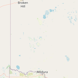
Map view of Danggali Conservation Park

Use this park location map to pinpoint Danggali Conservation Park in Australia, understand its exact geographic position, and read its mapped placement within the surrounding landscape more clearly.

Pigeon | © OpenStreetMap contributors

Location context for Danggali Conservation Park

South Australia
Park atlas

Compare surrounding semi-arid reserves and connected inland conservation landscapes.

Other Protected Areas and Parks Near Danggali Conservation Park in South Australia

Browse other protected areas and national parks situated near Danggali Conservation Park across the dry interior of South Australia. Comparing surrounding reserves reveals the ecological transition from river floodplains into extensive mallee scrublands.
Nature reserveNew South Wales
About 25 km away#1 closest

Northeast

Scotia Sanctuary: Protected Nature Reserve and Mallee Landscape Geography in New South Wales

Arid zone conservation and dune-swale mapping.

Scotia Sanctuary serves as a primary example of arid-zone conservation in south-western New South Wales. This reserve protects vast tracts of intact eucalypt mallee shrubland and sheoak woodland, set across a distinctive landscape of parallel sand dunes and calcareous swales. Its geographic position within the Murray-Darling Depression makes it a critical site for understanding the intersection of land management, habitat restoration, and regional ecological patterns.

Area
650 km²
Established
1994
Relief
Lowland
Climate
Arid
Watercolor painting of a pastoral landscape with soft green hills, distant pink-hued ridges, and pine trees.
Biosphere reserveSouth Australia
About 39 km away#2 closest

Northwest

Riverland Biosphere Reserve: Geography and Protected Landscapes in South Australia

Mapping the convergence of mallee woodland and riverine wetland ecosystems

Riverland Biosphere Reserve represents a significant landscape-scale conservation effort covering 9,000 square kilometres of South Australian terrain. The reserve encompasses an ecological mosaic, where arid, sandy mallee woodlands transition into a complex network of Murray River floodplains and riparian wetlands. This overview maps the protected area structure, highlighting the unique environmental interplay that supports essential bird populations and ecologically sustainable development.

Area
9,000 km²
Established
1977
Relief
Lowland
Climate
Arid
Nature reserveSouth Australia
About 42 km away#3 closest

Southwest

Calperum Station Nature Reserve: Mallee Landscapes and Riverland Wetlands in South Australia

Detailed geographic overview of a major Australian nature reserve.

Spanning over 2,300 square kilometers, Calperum Station preserves a vital stretch of mallee woodland and Murray River floodplain. This nature reserve serves as an international site for wetland conservation and provides a crucial stronghold for threatened bird species. The mapped area highlights the intersection of dryland dune-field ecology and riparian corridors, offering insight into large-scale habitat restoration.

Area
2,386 km²
Established
1993
Relief
Lowland
Climate
Arid
National parkAustralia
About 53 km away#4 closest

Southeast

Murray-Sunset National Park: Iconic Pink Lakes and Mallee Wilderness in Victoria's Semi-Arid Interior

Explore its unique landscape, mapped boundaries, and regional geography.

Murray-Sunset National Park offers a compelling glimpse into Australia's semi-arid heart, featuring a dramatic landscape of salt lakes, gypsum plains, extensive sand dunes, and dense mallee woodlands. This vast protected area is renowned for the vibrant pink hue of its salt lakes, a phenomenon created by microscopic algae that flourishes in the hypersaline conditions during warmer months. The park's rich biodiversity and unique ecosystem make it a significant conservation asset, providing crucial habitat for numerous species adapted to this challenging yet beautiful environment.

Area
6,330 km²
Established
1991
IUCN
II
Relief
Lowland
National parkSouth Australia
About 64 km away#5 closest

South

Murray River National Park: Protected Wetland Ecosystems in South Australia

Explore South Australia's unique river red gum floodplains.

Murray River National Park is a significant protected area in South Australia, renowned for its expansive wetland and floodplain environments situated along the Murray River. This national park preserves crucial habitats within the Murray-Darling Basin, characterized by river red gum woodlands, permanent water bodies, and dynamic seasonal floodplains. Its detailed maps and geographic context offer deep insights into one of Australia's most important riverine conservation landscapes.

Area
148.79 km²
Established
1991
IUCN
VI
Relief
Lowland
State or regional parkSouth Australia
About 71 km away#6 closest

South

Cooltong Conservation Park: Geography and Protected Mallee Woodland in South Australia

A regional conservation area defined by dune and shale flat topography

Cooltong Conservation Park is a protected state area in South Australia's Riverland. It features 37 square kilometres of mallee shrubland shaped by undulating dunes and shale flats. This conservation landscape is a recognized stronghold for birdlife, particularly the iconic Malleefowl, offering an authentic look at Australia's inland semi-arid terrain and its ecological connectivity.

Area
37.1 km²
Established
1993
IUCN
VI
Relief
Lowland
Wildlife reserveSouth Australia
About 77 km away#7 closest

Southwest

Taylorville Station Wildlife Reserve: Mallee Woodland Map and Regional Geography

Protected mallee landscapes in the Murray-Mallee, South Australia.

Taylorville Station provides a critical refuge for mallee-dependent species within its 92 square kilometres of semi-arid woodland. As a cornerstone of the Riverland Biosphere Reserve, this protected area in South Australia offers a unique look at the ecological significance of the Murray-Mallee region's persistent eucalypt vegetation and habitat management frameworks.

Area
92.6 km²
Established
2005
IUCN
IV
Visitors
2.7K annual
Protected areaSouth Australia
About 107 km away#8 closest

South

Kapunda Island Conservation Park: Atlas and Geographic Context of a Murray River Reserve

A protected sand-bar island in the South Australian Riverland

Located in the Murray River near Loxton, Kapunda Island Conservation Park serves as an important example of a riverine island environment. This protected area provides essential habitat, featuring river red gum woodland and lignum understorey that support local waterbird populations and regional biodiversity patterns.

Area
0.01 km²
Established
1968
IUCN
III
Relief
Lowland

Common questions about visiting, size, designation, and location context for Danggali Conservation Park

Danggali Conservation Park FAQs for park facts, access, geography, and protected area context

Find quick answers about Danggali Conservation Park, including protected-area facts, park geography, trail and visitor context, and how the park fits into its surrounding country and regional landscape.
MoriAtlas Explorer

Continue Your Protected Areas Search Across the Global Atlas

Deepen your exploration by continuing the structured search for national parks and protected areas worldwide. Utilize the comprehensive filtering capabilities to compare different conservation landscapes and refine your understanding of global park geography. Discover more about the distribution and characteristics of protected natural areas.

Global natural geography