Mori Atlas logo
Nature reserveDashanbao Black-necked Crane National Nature Reserve

High-altitude wetlands and subalpine marshland terrain within the Yunnan plateau ecosystem.

Dashanbao Black-necked Crane National Nature Reserve; Mapped Protected Landscapes in Zhaotong

Dashanbao Black-necked Crane National Nature Reserve encompasses a vast high-plateau landscape in Zhaotong, characterized by its distinctive subalpine wetlands and highland grasslands. As a globally significant wintering site for black-necked cranes, this protected area features a complex network of alpine lakes and reservoirs. Examine the geographic boundaries and ecological zoning of this essential nature reserve through our structured mapping and regional context.

black-necked cranewintering habitathigh-altitude wetlandssubalpine marshYunnan plateauRamsar site

Dashanbao Black-necked Crane National Nature Reserve

Nature reserve

Park overview

Structured park overview, official facts, and landscape profile for Dashanbao Black-necked Crane National Nature Reserve

Dashanbao Black-necked Crane National Nature Reserve park facts, protected area profile, and essential visitor context

Review the core facts for Dashanbao Black-necked Crane National Nature Reserve, including designation, size, terrain, visitor scale, habitats, and operating context in one park-focused overview.

About Dashanbao Black-necked Crane National Nature Reserve

Dashanbao Black-necked Crane National Nature Reserve occupies a high plateau at the edge of the Yunnan-Guizhou Plateau, in the northwestern part of Zhaoyang District, Zhaotong City, Yunnan Province. Although its altitude is modest by Himalayan standards, the reserve stands out as one of the highest elevation areas regularly used by black-necked cranes as winter habitat anywhere in their range.

The landscape is a mosaic of subalpine wetlands, gently rolling grasslands, rocky ridges, and scattered natural lakes. Three traditional natural lakes, known locally as Dahazi, Zhonghazi, and Xiaohai, along with the constructed Tiaodun River Reservoir, give the reserve its core wetland base. These shallow water bodies and surrounding marshy meadows form the heart of a fragile highland ecosystem that depends on seasonal snowmelt, summer rainfall, and careful protection of water quality.

At elevations ranging from roughly 2,210 meters to over 3,360 meters, Dashanbao experiences long, cold winters with regular snow cover, and short, cool summers. Conditions are windy and dry for much of the year, but the wetland basins hold water and food resources that allow large flocks of cranes to survive the winter. The reserve's protected status is shaped directly by the importance of these conditions to one of the rarest crane species on Earth.

Quick facts and research context for Dashanbao Black-necked Crane National Nature Reserve

Dashanbao Black-necked Crane National Nature Reserve is a national-level protected area in Zhaoyang District, Zhaotong, in the northeast of Yunnan Province. It covers the full administrative extent of Dashanbao township, an area of around 19,200 hectares, and is classified as a nationally important wetland under China's wetland system and was later recognized under the Ramsar Convention.

Elevations within the reserve range from approximately 2,210 meters to 3,364 meters, placing the ecosystem firmly within China's high-altitude subalpine environment. The reserve is best understood as a cold, seasonal highland wetland complex that supports the world's most significant known wintering population of black-necked cranes.

Protection and recognition

Documented terrestrial protection scope, designation year, and recognition history

Dashanbao Black-necked Crane National Nature Reserve Protection Status

Terrestrial protected area designation for Dashanbao Black-necked Crane National Nature Reserve is recorded from two thousand three. Structured conservation facts outline established management scope and administrative records for this protected landscape.

Protection details

Protection scope
Terrestrial
Designated year
2003
Transboundary protection
No
Core area
86.86 km²
Buffer area
48.9 km²
Park context

Deeper park guide and search-rich context for Dashanbao Black-necked Crane National Nature Reserve

Dashanbao Black-necked Crane National Nature Reserve history, landscape, wildlife, and travel context

Explore Dashanbao Black-necked Crane National Nature Reserve through its history, landscape character, ecosystems, wildlife, conservation priorities, cultural context, and seasonal travel timing in a structured park guide built for atlas discovery and search intent.

Why Dashanbao Black-necked Crane National Nature Reserve stands out

The reserve is best known for hosting one of the largest and densest known wintering populations of black-necked cranes anywhere in the world. Each year, more than a thousand cranes, representing a significant share of the global population, settle on Dashanbao's high-altitude wetlands during the cold season. These wintering grounds also represent the highest-elevation wintering habitat used by black-necked cranes, underscoring the reserve's unusual ecological character. The combination of broad highland marshes, shallow lakes, open grasslands, and a managed reservoir produces the mosaic of safe roosting and feeding conditions on which the cranes depend.
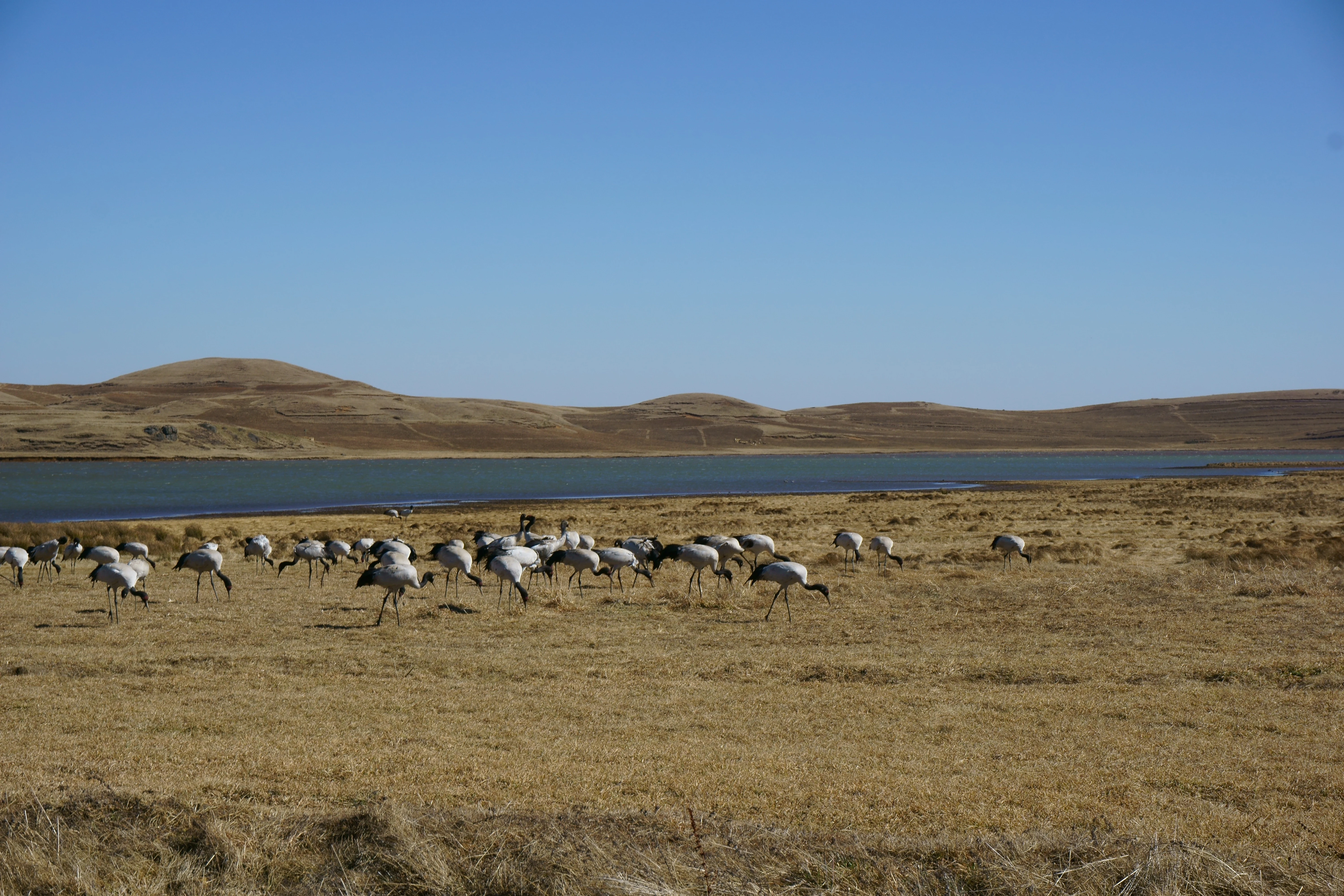
A group of black-necked cranes feeding in a dry, golden-grass field with a lake and rolling hills in the background under a clear blue sky.
A flock of black-necked cranes foraging in the grasslands of the Dashanbao reserve.

Dashanbao Black-necked Crane National Nature Reserve history and protected-area timeline

The reserve's history reflects a stepwise recognition of an increasingly important wetland and crane habitat. In January 1990, the Zhaotong municipal government approved the site as a city-level nature reserve, recognizing the local significance of the area's wetlands and crane populations. Just two months later, in March 1990, the Yunnan Provincial Government elevated the designation to a provincial nature reserve.

In January 2003, the State Council of China approved the reserve's promotion to a national-level nature reserve, establishing a dedicated deputy-director-level management bureau. The reserve was formally inaugurated on April 2, 2004, consolidating its management structure under national authority.

Recognition of the site's broader international importance followed in December 2004, when the reserve was designated under the Ramsar Convention as a Wetland of International Importance. These successive designations reflect a steady increase in understanding of Dashanbao's role as one of the most significant wintering strongholds for the black-necked crane in the world.

Dashanbao Black-necked Crane National Nature Reserve landscape and geographic character

The reserve sits on a high plateau of the Yunnan-Guizhou Plateau, with elevations mostly between approximately 3,000 and 3,200 meters above sea level. The highest point, Keche Liangzi, reaches 3,364 meters, while the lowest point lies near Banpo Village at around 2,210 meters, giving the protected area a meaningful internal range of altitude.

The terrain is shaped by a mix of gently undulating alpine grasslands, low ridges, broad seasonal marshlands, and shallow highland lakes. The three principal natural lakes of the reserve, Dahazi, Zhonghazi, and Xiaohai, together with the more recently built Tiaodun River Reservoir, create a network of open water bodies that act as the reserve's most important landscape features.

Snow cover for parts of the winter is a defining element of the reserve's seasonal character, and the wide marshy margins around the lakes give the area an expansive, open feel in winter. The combination of cold-climate grasslands and isolated water basins gives Dashanbao a stark, highland quality unusual within Yunnan Province.

Dashanbao Black-necked Crane National Nature Reserve ecosystems, habitats, and plant life

The reserve's ecological identity centers on its subalpine wetland system, which thrives at high elevation under cold-seasonal climate conditions. Annual average temperatures hover around 6.2 degrees Celsius, with summer averages only in the low teens and winter averages below freezing. The reserve experiences long sunshine hours, moderate seasonal precipitation, and a frost-free window of roughly 134 days per year, conditions that shape a relatively specialized set of wetland and grassland habitats.

Vegetation is dominated by montane and subalpine grassland communities intermixed with wetland flora around the lakes and along marsh margins. The reserve's mosaic of highland meadows, marshy lowlands, and open water provides a more habitat-rich frame than its largely treeless surroundings suggest, and the protected zones are structured around core wetland areas, buffer zones, and experimental zones to preserve habitat integrity.

The broader ecological significance of the reserve lies in its role as one of the highest-elevation platforms used by black-necked cranes anywhere on Earth. This rare habitat is one of the most distinctive examples of high-altitude winter wetland ecology in southern China.

Dashanbao Black-necked Crane National Nature Reserve wildlife and species highlights

Surveys of the reserve's fauna have recorded approximately 68 species across 28 families and 10 animal orders, reflecting a relatively specialized highland community rather than a broadly biodiverse forest habitat. The species composition is shaped by the reserve's elevation, openness, and cold-seasonal climate.

The black-necked crane itself is a Class I nationally protected species in China and is the unambiguous ecological and cultural centerpiece of the reserve. Each year, around one thousand black-necked cranes, drawn from a global population of roughly seven thousand birds, spend the winter within the reserve, with recorded winter counts peaking at around 1,131 individuals and average wintering durations reported between roughly 176 and 202 days.

Beyond the cranes, the reserve supports other high-altitude fauna adapted to its mix of wetlands and open grasslands. The combination of protected lakes, marshy margins, and surrounding pastures provides a refuge for waterbird and raptor species that share the cold-seasonal highland habitat, contributing to Dashanbao's status as a regionally important area for high-altitude birdlife.

Dashanbao Black-necked Crane National Nature Reserve conservation status and protection priorities

Dashanbao's conservation significance rests on its role as the most concentrated and one of the highest-elevation wintering habitats for the endangered black-necked crane. With roughly 1,000 of the species' global population of around 7,000 individuals gathering here each winter, the reserve carries significant responsibility for the species' long-term survival.

Its layered protection history, including municipal, provincial, national, and finally international Ramsar recognition, reflects consistent escalation in conservation status. This progression matches the growing scientific recognition of the site's importance and has allowed the establishment of a dedicated management bureau with focused responsibility for habitat and population protection.

The reserve's zoning into core, buffer, and experimental areas further supports conservation by concentrating the most sensitive wetland habitat under the strongest protections while allowing limited compatible use in surrounding zones. The combination of these design features, the cold-climate wetland ecosystem they protect, and the priority species they sustain gives Dashanbao an outsized conservation role relative to its geographic size.

Dashanbao Black-necked Crane National Nature Reserve cultural meaning and human context

The reserve has given Zhaoyang District of Zhaotong City a strong local identity as the home of the black-necked crane in China. The region is widely referred to as the 'Hometown of China's Black-necked Crane,' a reputation tied directly to the presence of the reserve and the seasonal spectacle of the wintering cranes.

Protection of the area has also shaped community identity in Dashanbao Township itself, whose administrative boundary coincides entirely with the reserve boundary. Local livelihoods, traditional land use, and conservation programs intersect across this shared terrain, giving the reserve both an ecological and a regional cultural anchor in northeastern Yunnan.

Top sights and standout views in Dashanbao Black-necked Crane National Nature Reserve

A standout feature of the reserve is its combination of unusually high elevation and reliable wetland habitat, producing one of the world's most important wintering grounds for the black-necked crane. The reserve's three natural lakes and a reservoir system create a network of safe roosting sites that concentrate cranes in close proximity, making it one of the best places to observe this rare species in its natural wintering environment.

Equally important is the reserve's international recognition under the Ramsar Convention, which places it among China's most formally significant wetlands. The reserve's national-level protection status and its layered zoning reflect a strong conservation framework that supports both wildlife and long-term ecological monitoring in a high-altitude setting rarely seen elsewhere in Yunnan.

Best time to visit Dashanbao Black-necked Crane National Nature Reserve

The most distinctive time to experience Dashanbao is during the winter months, when the area's harsh cold-climate conditions are at their most expressive and when the largest flocks of black-necked cranes arrive to occupy the wetlands. Cold temperatures, occasional snow cover, and clear air define the reserve's winter character and create the strongest viewing opportunities for cranes around Dahazi, Zhonghazi, Xiaohai, and the Tiaodun River Reservoir area.

The short summer season brings milder temperatures and greener highland grasslands, but the density and visibility of cranes are sharply reduced. Visitors interested primarily in the reserve's defining wildlife phenomenon generally find the winter months most rewarding, while visitors interested in the broader highland landscape may find the warmer season easier to access.
Monthly climate preview

Long-term representative temperature ranges and monthly precipitation distribution normals

Dashanbao Black-necked Crane National Nature Reserve Climate and Annual Weather Patterns

Representative coordinate records show average monthly temperatures shifting alongside distinct precipitation rhythms across the protected landscape. Examining the full twelve-month profile provides complete historical climate normals for deeper geographic analysis.
Annual mean12 °C
3 °C19 °C
Jan
Feb
Mar10°
Apr14°
May17°
Jun18°
Jul19°
Aug18°
Sep16°
Oct11°
Nov
Dec
Warmest month
July

18.6 °C

Coolest month
January

3.1 °C

Wettest month
July

6.1 mm/day

Driest month
December

0.2 mm/day

Park location guide

Geography guide, regional context, and park location map for Dashanbao Black-necked Crane National Nature Reserve

Dashanbao Black-necked Crane National Nature Reserve park geography, regions, and map view in China

Understand where Dashanbao Black-necked Crane National Nature Reserve sits in China through a broader geographic reading of the surrounding landscape, nearby location context, and its mapped position within the national park landscape.

How Dashanbao Black-necked Crane National Nature Reserve fits into China

China is a unitary communist state in East Asia, governed by the Chinese Communist Party. The country's capital is Beijing, while Shanghai is the largest city by urban population. China has 33 province-level divisions including provinces, autonomous regions, municipalities, and special administrative regions. The nation has a long history spanning thousands of years, with achievements including the invention of gunpowder, paper, printing, and the compass.

Wider geography shaping Dashanbao Black-necked Crane National Nature Reserve in China

China is located in East Asia, bordering fourteen countries: Russia, North Korea, Vietnam, Laos, Myanmar, India, Bhutan, Nepal, Pakistan, Afghanistan, Tajikistan, Kyrgyzstan, Kazakhstan, and Mongolia. The country spans diverse terrain including deserts, mountains, plateaus, and river valleys. Major river systems include the Yellow River and Yangtze River. The coastline stretches along the East China Sea, South China Sea, and Yellow Sea.

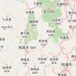
Map view of Dashanbao Black-necked Crane National Nature Reserve

Use this park location map to pinpoint Dashanbao Black-necked Crane National Nature Reserve in China, understand its exact geographic position, and read its mapped placement within the surrounding landscape more clearly.

Pigeon | © OpenStreetMap contributors

Location context for Dashanbao Black-necked Crane National Nature Reserve

YunnanZhaotong

Visualizing high-altitude wetlands, alpine grasslands, and wintering crane habitats across Yunnan

Dashanbao Black-necked Crane National Nature Reserve Landscape and Scenery Photos

Photographic records reveal the stark plateau terrain, subalpine marshlands, and open lake environments that define Dashanbao Black-necked Crane National Nature Reserve. Examining these protected-area visuals helps researchers understand high-elevation wintering habitats and regional ecological geography.

A group of black-necked cranes feeding in a dry, golden-grass field with a lake and rolling hills in the background under a clear blue sky.

Park atlas

Compare surrounding high-altitude wetlands, alpine grasslands, and regional highland landscapes

Parks Near Dashanbao Black-necked Crane National Nature Reserve and Related Protected Areas

Continue geographic discovery by comparing Dashanbao Black-necked Crane National Nature Reserve with other protected areas across the surrounding Yunnan plateau region. Analyzing nearby wetland reserves and high-elevation habitats provides broader context for regional conservation corridors and highland ecosystems.
National parkChina
About 184 km away#1 closest

Northeast

Giant Panda National Park: China's Premier Panda Habitat and Protected Landscape

Mapped terrain and conservation significance in the mountains of western China.

Giant Panda National Park is a critically important protected area in China, established to conserve the primary habitat for the giant panda. This national park, spanning a vast mountainous region across Sichuan, Gansu, and Shaanxi, integrates numerous former reserves into a unified landscape. It serves as a vital sanctuary, protecting approximately 80 percent of the world's wild panda population and offering deep insights into the geographic distribution and ecological requirements of these endangered animals.

Area
27,134 km²
Established
2020
IUCN
II
Relief
Mountain
Wide watercolor painting of tall pale rock formations in a green field under a pastel sky.
Protected landscapeYunnan
About 286 km away#2 closest

South

Shilin Scenic Area: Mapping the Karst Pinnacles and Protected Landscape of Yunnan

A detailed look at limestone morphology and plateau geography.

Shilin Scenic Area offers a comprehensive study of karst pinnacle development within the Yunnan province. The terrain is characterized by jagged limestone towers, deep solution fissures, and intricate subsurface drainage, providing a clear example of plateau-based geological processes. This protected area stands as a central feature in regional geography, showcasing both surface stone forests and hidden cave environments.

Established
1982
A minimalist watercolor painting featuring soft, abstract layers of rolling green hills in the midground and pale, hazy mountain peaks in the background, set against a light background.
Nature reserveSichuan
About 319 km away#3 closest

West

Sichuan Yading National Nature Reserve: Mapped Protected Landscapes in Western Sichuan

High altitude terrain, glaciated peaks, and alpine geography.

Sichuan Yading National Nature Reserve is a significant protected area in the Garzê Tibetan Autonomous Prefecture, home to the Three Holy Mountains and extensive glacial features. This entry details the reserve geography, focusing on the distribution of alpine meadows, high elevation forests, and the dramatic vertical landscape carved by the Litang River tributaries.

Area
3,815.06 km²
Established
1996
Relief
Mountain
Climate
Alpine
Nature reserveSichuan
About 374 km away#4 closest

North

Wolong National Nature Reserve: Mapping Sichuan's Rugged Mountain Protected Lands

A critical mountain nature reserve in the Qionglai range.

Delve into the geography of Wolong National Nature Reserve, a cornerstone of China's protected areas. This site offers insight into the vertical ecology of the eastern Qionglai Mountains, where steep river valleys and extensive bamboo forests characterize the transition toward the Tibetan Plateau. Access map-based insights into this essential wildlife corridor and its role in the larger regional landscape.

Area
2,000 km²
Established
1963
Relief
Mountain
Climate
Alpine
Protected areaYunnan
About 484 km away#5 closest

West

Three Parallel Rivers of Yunnan Protected Areas: Mapped Geography and Protected Mountain Terrain

An atlas perspective on the Hengduan Mountain river corridor

The Three Parallel Rivers of Yunnan Protected Areas represents a unique geographic phenomenon in the Hengduan Mountains of China. The protected area is defined by deep, parallel river canyons, massive snow-capped peaks, and an exceptional vertical range of ecosystems. This atlas entry focuses on the regional layout, mapped mountain corridors, and the ecological significance of a site where three major rivers flow in close proximity for over 170 kilometers.

Area
17,000 km²
Established
2003
Relief
Mountain
Climate
Alpine
National parkMyanmar
About 487 km away#6 closest

West

Emawbum National Park: Myanmar's Protected National Park Landscape Identity

Explore the geography and mapped boundaries.

Emawbum National Park offers a distinct focus for understanding protected areas within Myanmar. This detail page facilitates an exploration of its unique geographic setting and the mapped extent of its protected landscape. Discover what makes this national park a vital component of regional geographic context for atlas-based discovery and conservation insights.

IUCN
II
National parkKachin State
About 540 km away#7 closest

West

Hkakaborazi National Park: National Park Protected Landscape and Map Explorer

Explore its mapped boundaries and regional geography in Kachin State.

Hkakaborazi National Park serves as a critical protected area within Kachin State, offering a unique geographic profile for atlas and map exploration. This dedicated entry focuses on its identity as a national park, detailing its mapped landscape context and its role within the broader protected areas network. Understand the specific geographic features and boundaries that define this important natural landscape, essential for any detailed cartographic or regional study.

Area
3,810 km²
Established
1998
IUCN
II
Relief
Mountain
National parkLào Cai Province
About 571 km away#8 closest

South

Hoàng Liên National Park: Vietnam's Highest Mountain and Botanical Treasure in Lào Cai Province

Discover exceptional mountain terrain and unique endemic species habitat.

Hoàng Liên National Park stands as a critical protected landscape in Lào Cai Province, Vietnam, centered around the iconic Fansipan mountain, the highest point in the Indochinese Peninsula. This national park is renowned as a globally important center for plant diversity, showcasing varied mountain terrain from lush evergreen forests to subalpine ecosystems. Explore the mapped boundaries and geographic context of this significant highland protected area, a key destination for understanding Southeast Asian botanical richness.

Area
685.69 km²
Established
2002
IUCN
II
Relief
Mountain

Common questions about visiting, size, designation, and location context for Dashanbao Black-necked Crane National Nature Reserve

Dashanbao Black-necked Crane National Nature Reserve FAQs for park facts, access, geography, and protected area context

Find quick answers about Dashanbao Black-necked Crane National Nature Reserve, including protected-area facts, park geography, trail and visitor context, and how the park fits into its surrounding country and regional landscape.
MoriAtlas Explorer

Continue Your Protected Areas Search Across the Global Atlas

Deepen your exploration by continuing the structured search for national parks and protected areas worldwide. Utilize the comprehensive filtering capabilities to compare different conservation landscapes and refine your understanding of global park geography. Discover more about the distribution and characteristics of protected natural areas.

Global natural geography