

Mori Atlas logo
Protected landscapeDe Himmerlandske Heder

Examining the glacial moraine ridges, dune formations, and ecological connectivity of northern Jutland

De Himmerlandske Heder: A Mapped Analysis of Denmark's Inland Heathland Protected Landscapes

De Himmerlandske Heder represents a critical belt of interconnected heathland environments located across the municipalities of Aalborg and Vesthimmerland. This protected landscape is defined by its glacial moraine substrate, inland dune formations, and stream-carved valleys that trace the region west of the Limfjorden. Through structured mapping, this resource details the ecological importance of this Natura 2000 site as a stronghold for heathland conservation and butterfly habitat in northern Denmark.

heathlandinland dunesdry heathNatura 2000EU habitat areabutterfly conservation

De Himmerlandske Heder

Protected landscape

Park overview

Structured park overview, official facts, and landscape profile for De Himmerlandske Heder

De Himmerlandske Heder park facts, protected area profile, and essential visitor context

Review the core facts for De Himmerlandske Heder, including designation, size, terrain, visitor scale, habitats, and operating context in one park-focused overview.

About De Himmerlandske Heder

De Himmerlandske Heder represents a distinctive cluster of protected heathlands in the northern Himmerland region of Denmark, situated west of the Halkær Bredning inlet of the Limfjorden. Although it is not a single administratively unified national park, the area functions as a coherent ecological landscape, with several named heaths forming a near-continuous belt of open, dry, low-vegetation habitat across the municipalities of Aalborg and Vesthimmerland.

The defining geographic spine of the area is a low sand-rich moraine ridge that runs roughly east to west. At its western end lies Vindblæs Hede, where the Herredsbæk stream rises; at its eastern end, around nine kilometers away, lies Kyø Dale near the Vidkær Å. Between these endpoints, Oudrup Hede and Lundby Hede are separated by the Bruså, which flows northward and later continues as Dybvad Å before emptying into the Limfjorden. This combination of dry upland heaths and intersecting stream valleys gives the landscape its varied structural character, supporting both acid heath communities and small wetland transitions.

Ecologically, the area sits at the intersection of glacial, aeolian, and biological history. The sandy moraine hills were once affected by sand drift, leaving behind crowberry-covered inland dunes east of Vindblæs Hede. Over time, vegetation stabilized, and a characteristic heathland mosaic developed. Today, a substantial protected core, approximately 1,387 hectares, sits within Natura 2000 plan area 19 and is recognized as an EU habitat area, giving the site formal status in Denmark's broader effort to preserve representative heathland and dune habitats.

Beyond its natural value, the area has a meaningful cultural identity. It was memorably depicted by Danish author Johannes V. Jensen in his Himmerlandshistorier, a literary cycle that helped define the regional imagination of Himmerland. The combination of literary recognition, ecological significance, and protected-area status makes De Himmerlandske Heder a notable reference landscape for understanding both the natural and cultural heritage of northern Jutland.

Quick facts and research context for De Himmerlandske Heder

De Himmerlandske Heder is a belt of protected heathland in northern Himmerland, Denmark, comprising several named heaths including Vindblæs Hede, Oudrup Hede, Lundby Hede, Ajstrup Hede, and Kyø Dale. The protected core covers roughly 1,387 hectares and forms part of Natura 2000 plan area 19, recognized as an EU habitat area. The landscape follows a moraine ridge between Nibe, Års, and Løgstør, west of the Halkær Bredning arm of the Limfjorden. The site supports inland dune formations, heather-dominated dry habitats, and small river valleys, and is nationally significant for its population of the Hedepletvinge butterfly.

Protection and recognition

Explore terrestrial protection metrics and official conservation history.

De Himmerlandske Heder Protection Status and Designated Area Record

De Himmerlandske Heder maintains a documented terrestrial protection scope within regional conservation frameworks. Structured facts assemble verified management details and official international recognition records for analysis.

Protection details

Protection scope
Terrestrial
Transboundary protection
No
Park context

Deeper park guide and search-rich context for De Himmerlandske Heder

De Himmerlandske Heder history, landscape, wildlife, and travel context

Explore De Himmerlandske Heder through its history, landscape character, ecosystems, wildlife, conservation priorities, cultural context, and seasonal travel timing in a structured park guide built for atlas discovery and search intent.

Why De Himmerlandske Heder stands out

De Himmerlandske Heder is best known for being one of Denmark's most significant inland heathland complexes, a chain of dry heaths stitched together by glacial moraine ridges and historically reshaped by sand drift. The area is celebrated for its inland dune formations, where crowberry-covered relic dunes rise among the heather, and for the ecological importance of its open, sun-exposed habitat structure. The site also stands out for its role in butterfly conservation, particularly as a stronghold for the Hedepletvinge, one of Denmark's rarest heathland butterflies. Through the LIFE ASPEA project, the area has become a focal point for habitat management efforts aimed at maintaining and expanding conditions suitable for this species, making it a key reference site for open heathland ecology in northern Jutland.
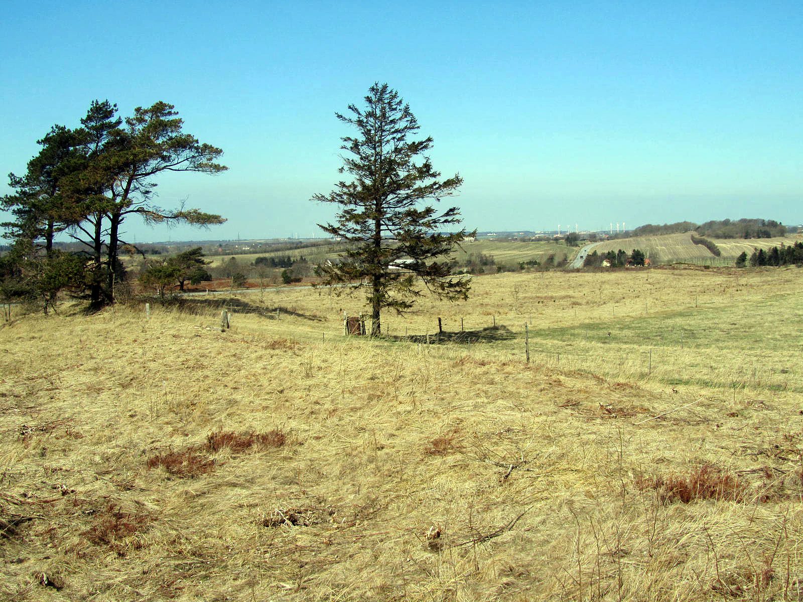
Vindblaes Hede
View of the Vindblaes Hede area within De Himmerlandske Heder, looking north.

De Himmerlandske Heder history and protected-area timeline

The landscape of De Himmerlandske Heder has been shaped by a long interplay between glacial deposition, aeolian sand movement, and human use of marginal land. The underlying terrain consists of sandy moraine hills, deposited during the last glacial period, which were subsequently exposed to sand drift. At its peak, sand drift destabilized parts of the landscape, leading to the formation of inland dune features, particularly east of Vindblæs Hede, where crowberry-bearing relic dunes remain visible among the heath today.

In modern times, the heaths gained formal protection as part of Denmark's broader nature conservation framework. A significant area, around 1,387 hectares, was designated as protected land, and the area was incorporated into the Natura 2000 network as plan area 19, covering Lundby Hede, Oudrup Østerhede, and Vindblæs Hede. It is also recognized as an EU habitat area, reflecting its importance under the European Union's Habitats Directive.

More recently, the site has been drawn into active conservation projects focused on its specialist fauna. Through the LIFE ASPEA initiative, targeted measures have been taken to improve habitat conditions for the Hedepletvinge butterfly on Lundby Hede, with documented increases in both population size and range. Culturally, the landscape has long been part of the Himmerland regional identity, famously evoked in Johannes V. Jensen's Himmerlandshistorier, a body of work that has helped cement the area's place in Danish literary and regional imagination.

De Himmerlandske Heder landscape and geographic character

The physical landscape of De Himmerlandske Heder is defined by a low moraine ridge running through northern Himmerland, with heathland dominating its broad, sandy upper terraces. The underlying substrate is glacial moraine, much of it sand-rich, which has shaped both the soils and the vegetation patterns of the area. West of the Halkær Bredning inlet of the Limfjorden, the land rises gently to form the dry upland platform on which the heaths have developed, before declining toward wetter lowlands along the stream corridors.

Among the most visually distinctive features of the area are the inland dune formations, particularly the crowberry-covered relic dunes east of Vindblæs Hede. These dunes are remnants of a period when sand drift reshaped parts of the moraine landscape, leaving isolated sand mounds now stabilized under heath vegetation. Their presence gives parts of the heath a subtly rolling, dune-like character that sets De Himmerlandske Heder apart from many flatter Danish heaths.

The hydrology of the area also contributes to its landscape diversity. The Herredsbæk rises in the southern part of Vindblæs Hede, while the Bruså separates Oudrup Hede and Lundby Hede, flowing northward before becoming Dybvad Å and eventually reaching the Limfjorden. Further east, Kyø Dale near the Vidkær Å marks the eastern extent of the heath belt. Together, these stream corridors punctuate the otherwise dry heath matrix, creating gradients between open heather, scrub, and damp valley vegetation.

De Himmerlandske Heder ecosystems, habitats, and plant life

Ecologically, De Himmerlandske Heder exemplifies the open, low-nutrient heathland systems characteristic of sand-rich glacial landscapes in northern Europe. The dominant habitat is dry heath, structured around low evergreen and ericaceous shrubs adapted to acidic, well-drained soils. Across the belt, this dry heath is interspersed with inland dune habitats where crowberry and other dune-tolerant species persist as relic communities from earlier phases of landscape instability.

The mosaic of habitats created by the combination of dry upland heaths, inland dunes, and intersecting stream valleys supports a range of heathland ecological niches. Where the Bruså valley cuts between Oudrup Hede and Lundby Hede, and where the Herredsbæk and Vidkær Å form corridor systems, transitions occur between dry heath and more humid vegetation, adding structural diversity to the landscape.

As part of Natura 2000 plan area 19 and an EU habitat area, the site is formally designated for the conservation of representative heathland and dune habitats. Beyond the broad habitat framework, the area is notable for the ecological role of its specialist invertebrates, which depend on the open, sun-exposed structure of the heath. Management efforts associated with the LIFE ASPEA project reflect the importance of maintaining this open habitat character, which is essential not only for the heathland flora but also for the butterflies and other fauna that depend on it.

De Himmerlandske Heder wildlife and species highlights

The wildlife profile of De Himmerlandske Heder is defined less by large mammals and more by the specialist invertebrates and birdlife supported by its open heathland and dune habitats. The area is best known nationally for its population of the Hedepletvinge, a rare heathland butterfly that depends on the specific structure of dry, low-vegetation heath. On Lundby Hede, this butterfly has been the subject of targeted conservation, and the population has been documented as increasing in both number and spatial extent through the LIFE ASPEA project. This site hosts one of only two known populations south of the Limfjorden, making it nationally significant for the species' persistence in this part of Denmark.

The presence of inland dune formations adds further ecological nuance, as these sandy relic features support microhabitats distinct from the surrounding heath. The combination of dry heath, inland dunes, and stream-side transitions provides niches for various heat-loving invertebrates, ground-nesting birds typical of open Danish heathland, and the broader fauna associated with nutrient-poor sandy landscapes.

Overall, the wildlife character of the area reflects the broader ecological identity of northern Jutland's heath belts: a relatively modest but ecologically specialized fauna, with particular significance for conservation due to the rarity and habitat specificity of certain species, especially within the invertebrate community.

De Himmerlandske Heder conservation status and protection priorities

De Himmerlandske Heder holds a meaningful place in Denmark's conservation framework, both as a nationally protected landscape and as part of the European Natura 2000 network. A core area of approximately 1,387 hectares is formally protected, and the heaths are integrated into Natura 2000 plan area 19, which encompasses Lundby Hede, Oudrup Østerhede, and Vindblæs Hede. The site is also designated as an EU habitat area, reflecting its recognition under the European Union's Habitats Directive for its representative heathland and dune habitats.

Conservation efforts in the area are particularly focused on maintaining the open, dry structure of the heathland, which is essential for the persistence of specialist species and the integrity of inland dune communities. Through the LIFE ASPEA project, active habitat management has been implemented to improve conditions for the Hedepletvinge butterfly, a species of significant conservation concern in Denmark. The project has combined habitat improvement with public awareness efforts, helping to anchor the site's role as a reference heathland landscape in northern Jutland.

By combining formal protected-area designation with active species-targeted management, De Himmerlandske Heder illustrates how Danish heath conservation integrates broad habitat protection with specific biodiversity recovery goals, particularly for species tied to open, low-nutrient landscapes.

De Himmerlandske Heder cultural meaning and human context

The Himmerland region of northern Jutland has long held a distinctive cultural identity within Denmark, and De Himmerlandske Heder occupies an evocative place within that identity. The area is perhaps most famously tied to the literary work of Johannes V. Jensen, whose Himmerlandshistorier shaped a lasting image of the region's heaths, villages, and rural life. Jensen's depiction of Himmerland contributed significantly to how northern Denmark's open landscapes were understood culturally, both within Denmark and beyond.

The cultural dimension of the heathlands is rooted in part in their marginal character: sandy, dry, and historically harder to cultivate than surrounding lands, they supported traditional land uses such as grazing, turf cutting, and other forms of rural resource use. Over time, these uses helped shape the open character of the heaths that persists today. The area's enduring presence in regional imagination, anchored by Jensen's writing and reinforced by modern conservation identity, gives De Himmerlandske Heder a cultural depth that goes well beyond its ecological footprint.

Top sights and standout views in De Himmerlandske Heder

De Himmerlandske Heder stands out as one of Denmark's most significant inland heathland landscapes, combining dry heath, inland dunes, and stream valleys into a single ecological belt. Its inclusion in the Natura 2000 network and its status as an EU habitat area underline its formal importance for European heathland conservation.

Among its most distinctive highlights are the crowberry-covered inland dunes east of Vindblæs Hede, the nationally important population of the Hedepletvinge butterfly on Lundby Hede, and the cultural resonance of Johannes V. Jensen's Himmerlandshistorier. Together, these features make the area both an ecologically meaningful site and a rich point of reference for the cultural heritage of the Himmerland region.

Best time to visit De Himmerlandske Heder

The character of De Himmerlandske Heder shifts with the seasons in ways that reflect its open heathland identity. In late summer and early autumn, the heather typically comes into bloom across Danish heathlands, transforming the landscape into broad swaths of purple-pink color and offering the most iconic visual experience of the area. This period also tends to coincide with peak insect activity, making it a particularly good time for observing the heathland's specialist invertebrate fauna, including the Hedepletvinge on Lundby Hede.

In spring and early summer, the heathlands tend to be quieter and greener, with cooler conditions and a less dramatic but still distinctive open-landscape atmosphere. Winter visits offer a different perspective entirely, with the low heath vegetation, inland dune forms, and moraine topography laid bare under subdued light, allowing the underlying landforms to stand out more clearly. Across all seasons, the area's open character and protected status mean that access generally allows visitors to experience the landscape under a wide range of conditions.

Monthly climate preview

Long-term representative monthly averages and temperature ranges for De Himmerlandske Heder in Denmark

De Himmerlandske Heder Climate Normals, Annual Temperature and Precipitation Patterns

Historical climate data from 1991 to 2020 documents monthly mean temperatures ranging from 1.23 degrees Celsius in February to 16.66 degrees Celsius in August alongside daily precipitation averages between 1.70 and 3.08 millimeters. Detailed monthly breakdowns provide deeper insight into temperature extremes and precipitation distribution across the representative park coordinate.
Annual mean8 °C
1 °C17 °C
Jan
Feb
Mar
Apr
May11°
Jun14°
Jul17°
Aug17°
Sep14°
Oct
Nov
Dec
Warmest month
August

16.7 °C

Coolest month
February

1.2 °C

Wettest month
October

3.1 mm/day

Driest month
April

1.7 mm/day

Park location guide

Geography guide, regional context, and park location map for De Himmerlandske Heder

De Himmerlandske Heder park geography, regions, and map view in Denmark

Understand where De Himmerlandske Heder sits in Denmark through a broader geographic reading of the surrounding landscape, nearby location context, and its mapped position within the national park landscape.

How De Himmerlandske Heder fits into Denmark

Denmark is a constitutional monarchy and Nordic country in Northern Europe. It is the southernmost of the Scandinavian countries, bordering Germany to the south, Norway to the north, and Sweden to the southwest. The country consists of the Jutland peninsula and an archipelago of islands, with Copenhagen as its capital and largest city. Denmark has a population of over 6 million and is characterized by flat, arable land, sandy coasts, and a temperate climate.

Wider geography shaping De Himmerlandske Heder in Denmark

Denmark occupies the Jutland peninsula and roughly 406 islands in Northern Europe. It is situated between the North Sea to the west and the Baltic Sea to the east. The country borders Germany to the south and is connected to Sweden via the Øresund Bridge. Denmark is predominantly flat terrain with low elevation, the highest point being Møllehøj at 170.86 meters.

Map view of De Himmerlandske Heder

Use this park location map to pinpoint De Himmerlandske Heder in Denmark, understand its exact geographic position, and read its mapped placement within the surrounding landscape more clearly.

Pigeon | © OpenStreetMap contributors

Visual exploration of inland dunes, dry heath habitats, and glacial terrain

De Himmerlandske Heder Photos and Protected Landscape Scenery

Photographic records reveal the open heathland belt, glacial moraine ridges, and crowberry-covered inland dunes defining De Himmerlandske Heder. Visual reference materials illustrate the terrain, dry heath matrix, and protected habitats spanning the northern Himmerland landscape.

Vindblaes Hede

Vindblaes Hede at Himmerlandske Heder

Park atlas

Compare nearby protected areas and regional heathland geography in northern Jutland

Exploring Parks Near De Himmerlandske Heder and Surrounding Protected Landscapes

Continue comparing natural terrain by browsing other protected areas located near De Himmerlandske Heder and the surrounding regional landscape. Evaluating connected habitats offers broader context on regional conservation corridors and northern Danish ecosystems.
Protected areaHimmerland
About 12 km away#1 closest

Southeast

Sønderup Ådal Protected Area: Himmerland Glacial River Valley Geography and Mapping

Protected riparian landscapes and glacial terrain in northern Denmark

Sønderup Ådal represents a distinct natural feature in Himmerland, defined by a deep 40-meter incision into the glacial terrain. This protected area supports rare oak scrub habitats and a meandering stream course, serving as a critical example of preserved river valley geography within the broader Danish landscape.

Area
8.4 km²
Established
1949
Nature reserveRegion Nordjylland
About 37 km away#2 closest

Northwest

Lild Strand og Lild Strandkær: A Detailed Look at Denmark's Protected Coastal Dune Terrain

Mapping the dune heath, wetlands, and inland lakes of western Thy

Lild Strand og Lild Strandkær encompasses a significant protected landscape in Region Nordjylland. This site features a continuous stretch of coastal dune zonation, including foredunes and grey-green dunes, set against a chain of distinctive brown-water and Lobelia lakes. Its habitat mosaic offers a clear window into the ecological diversity of the Thy coastline through a structured geographic lens.

Area
7.49 km²
Established
2011
Relief
Lowland
Scope
Terrestrial
Nature reserveRegion Nordjylland
About 42 km away#3 closest

Northwest

Korsø Knude Nature Reserve: Protected Chalk Headland and Coastal Terrain in Northern Jutland

Geographic analysis of lime-rich grassland and coastal dune systems

Korsø Knude protects a rare habitat mosaic where chalk geology meets shifting dune sand. This small but significant area in Region Nordjylland serves as a key site for specialized calcareous flora and coastal biodiversity, offering a distinct example of the Skagerrak coastline's natural terrain.

Area
0.2 km²
Established
1955
Relief
Upland
Climate
Temperate
Watercolor illustration of a landscape with trees, water, and distant hills
National parkDenmark
About 47 km away#4 closest

West

Thy National Park: Explore Denmark's First Protected Coastal Landscape and Heathlands

Mapped dune systems, rare heath habitats, and coastal geography.

Thy National Park, Denmark's inaugural national park, protects a significant expanse of windswept coastal terrain. This area is renowned for its rare dune heaths, a habitat of particular European ecological importance, and a landscape shaped by a century of sand drift stabilization efforts. The park's diverse geography includes extensive sandy heaths, conifer plantations, and a striking coastline along the North Sea, offering rich opportunities for atlas exploration of protected natural areas and their surrounding regional context. Discover the mapped extent of this vital conservation landscape.

Area
244 km²
Established
2007
IUCN
II
Relief
Lowland
Protected areaCentral Denmark Region
About 48 km away#5 closest

South

Fiskbæk Å Protected Area: Geographic Context and Mapped Valley Features in Central Denmark

Restored freshwater corridors and heathland mosaic geography.

Fiskbæk Å functions as a vital protected landscape in the Central Denmark Region, spanning a complex valley system that includes former lake basins and spring-fed wetlands. This detailed view captures the stream's transition from high-ground heath to the Hjarbæk Fjord, highlighting its role as a formally recognized Natura 2000 habitat area.

Area
1.71 km²
Established
1984
Relief
Lowland
Climate
Temperate
Nature reserveRegion Nordjylland
About 49 km away#6 closest

West

Mågerodde og Karby Odde Nature Reserve: Coastal Protected Landscapes in Region Nordjylland

Limfjorden shoreline, shallow bays, and saline meadows.

Mågerodde og Karby Odde serves as a key coastal reserve in Denmark, defined by its extensive Limfjorden shoreline and complex mix of aquatic and terrestrial habitats. From saline meadows and coastal lagoons to acidic grasslands and spring-fed mires, this protected area offers a look at a diverse maritime ecosystem. The site is recognized for its importance to migratory waterfowl and breeding coastal birds, providing a essential link in the regional geography of the Limfjorden.

Area
4.97 km²
Established
2011
Relief
Lowland
Climate
Temperate
Protected areaDenmark
About 54 km away#7 closest

South

Ø Bakker Protected Area: A Map of the Heath-Covered Ridge in Central Jutland, Denmark

Glacial ridge geography in the Nørreå valley

Ø Bakker stands as a striking geological landmark where a heather-clad hill ridge rises sharply from the lowland meadows of Denmark. This protected area offers clear insights into the undulating terrain and dry heath habitats preserved between the meanders of the Nørreå river, providing a valuable study in regional glacial geomorphology and conservation mapping.

Area
2.85 km²
Established
1975
Relief
Upland
Climate
Temperate
Nature reserveCentral Denmark Region
About 54 km away#8 closest

South

Natura 2000-område nr. 39 Mønsted og Daugbjerg Kalkgruber og Mønsted Ådal Geography and Map

Subterranean chalk mines and river valley ecosystems in Central Denmark

This protected area offers a look at a varied mosaic of habitats in central Jutland, spanning steep valley slopes, heath plateaus, and historic subterranean chalk mine complexes. The region acts as a vital habitat for bat species and rare moss flora, defined by its groundwater-fed spring mires and the pristine waters of Birkesø lake.

Area
7.4 km²
Established
2011
Relief
Lowland
Scope
Terrestrial

Common questions about visiting, size, designation, and location context for De Himmerlandske Heder

De Himmerlandske Heder FAQs for park facts, access, geography, and protected area context

Find quick answers about De Himmerlandske Heder, including protected-area facts, park geography, trail and visitor context, and how the park fits into its surrounding country and regional landscape.
MoriAtlas Explorer

Continue Your Protected Areas Search Across the Global Atlas

Deepen your exploration by continuing the structured search for national parks and protected areas worldwide. Utilize the comprehensive filtering capabilities to compare different conservation landscapes and refine your understanding of global park geography. Discover more about the distribution and characteristics of protected natural areas.

Global natural geography