

Mori Atlas logo
Wildlife reserveD'Ering Memorial Wildlife Sanctuary

Mapped floodplain ecosystems, grassland mosaics, and riverine forest terrain in northeast India.

D'Ering Memorial Wildlife Sanctuary in the Eastern Himalayan Foothills of Arunachal Pradesh

D'Ering Memorial Wildlife Sanctuary stands as a vital protected area situated along the Siang river system in Arunachal Pradesh. This 190 square kilometer reserve is defined by a dynamic floodplain geography where expansive open grasslands meet riparian corridors and bamboo stands. The landscape serves as a managed habitat for diverse species, illustrating the ecological intersection of the eastern Himalayan foothills and the Brahmaputra basin's alluvial plains.

grasslandfloodplainriverine foresttiger habitatleopard habitateastern Himalayas foothills

D'Ering Memorial Wildlife Sanctuary

Wildlife reserve

Park overview

Structured park overview, official facts, and landscape profile for D'Ering Memorial Wildlife Sanctuary

D'Ering Memorial Wildlife Sanctuary park facts, protected area profile, and essential visitor context

Review the core facts for D'Ering Memorial Wildlife Sanctuary, including designation, size, terrain, visitor scale, habitats, and operating context in one park-focused overview.

About D'Ering Memorial Wildlife Sanctuary

D'Ering Memorial Wildlife Sanctuary occupies a defined block of the Siang river floodplain in the state of Arunachal Pradesh, in the far northeast of India. The protected area sits within a lowland belt where Himalayan rivers descend toward the Brahmaputra basin, and the resulting terrain is shaped by seasonal flooding, silt deposition, and the gradual transition between aquatic margins, wet grassland, and wooded patches.

The sanctuary covers approximately 190 square kilometers, an area dominated by grassland. Roughly 80% of this landscape is open grassland, giving the reserve a savanna-like feel that differs from the dense closed-canopy forests more typical of the eastern Himalayas. The remaining area is composed of riverine forest mixed with bamboo and secondary forest growth, which tends to fringe the waterways, occupy slightly higher ground, and provide structural contrast against the open plains.

Wildlife presence is an important part of the sanctuary's identity. The reserve supports populations of large felids including tiger and leopard, which use the mosaic of cover and open ground for movement and hunting. The Indian hare is described as particularly common across the grassland areas, reflecting the suitability of the open habitat for smaller ground-dwelling mammals. Together, these ecological features position D'Ering Memorial Wildlife Sanctuary as a representative floodplain grassland reserve and a significant protected habitat within Arunachal Pradesh's wider network of conservation areas.

Quick facts and research context for D'Ering Memorial Wildlife Sanctuary

D'Ering Memorial Wildlife Sanctuary is located in Arunachal Pradesh in northeastern India, within the Siang river floodplain landscape. It was established as a protected area in 1978 and covers approximately 190 square kilometers. The sanctuary is designated as an IUCN Category IV protected area, focused on habitat and species management.

Roughly four-fifths of the sanctuary is open grassland, with the remainder made up of riverine forest, bamboo, and secondary forest. It supports resident populations of large cats including tiger and leopard, alongside a notable population of Indian hare across its open habitats.

Protection and recognition

Examine terrestrial protection scope, designation history, and recognized conservation frameworks

D'Ering Memorial Wildlife Sanctuary Protection Status and Designation Records

D'Ering Memorial Wildlife Sanctuary maintains documented terrestrial protection status within official conservation inventories. Structured records outline the designated management scope and available international recognition details for this protected area.

Protection details

Protection scope
Terrestrial
Park context

Deeper park guide and search-rich context for D'Ering Memorial Wildlife Sanctuary

D'Ering Memorial Wildlife Sanctuary history, landscape, wildlife, and travel context

Explore D'Ering Memorial Wildlife Sanctuary through its history, landscape character, ecosystems, wildlife, conservation priorities, cultural context, and seasonal travel timing in a structured park guide built for atlas discovery and search intent.

Why D'Ering Memorial Wildlife Sanctuary stands out

D'Ering Memorial Wildlife Sanctuary is best known for its expansive floodplain grasslands bordered by riverine forest, where the open habitat character sets it apart from many of the more forested reserves in the region. The sanctuary's combination of grassland and riparian woodland creates conditions favorable for both large predators such as tiger and leopard, and for smaller open-country mammals like the Indian hare. The sanctuary also stands out as one of the prominent grassland-dominated wildlife sanctuaries in Arunachal Pradesh, illustrating how the Siang river basin supports a distinctive mosaic of wet meadow and forest habitat in the eastern Himalayan foothills.

D'Ering Memorial Wildlife Sanctuary history and protected-area timeline

D'Ering Memorial Wildlife Sanctuary was established in 1978 as a protected area under Indian wildlife conservation frameworks. Its designation reflects the recognition of the Siang floodplain landscape as a habitat worth formal protection, particularly given the mix of grassland and riverine forest it contains. The sanctuary is currently classified as an IUCN Category IV protected area, indicating its primary role in managing habitats and species rather than being a strict nature reserve.

Beyond its formal establishment, the sanctuary's history is tied to the broader conservation significance of the Brahmaputra basin lowlands in Arunachal Pradesh, where riverine and grassland systems have long supported distinctive wildlife. The 1978 designation marked the beginning of its institutional role as a managed protected landscape within the state.

D'Ering Memorial Wildlife Sanctuary landscape and geographic character

The landscape of D'Ering Memorial Wildlife Sanctuary is defined by the floodplain of the Siang river system in eastern Arunachal Pradesh. The terrain is predominantly low-lying, shaped by the actions of the river, with seasonally flooded zones, silt flats, and elevated strips that remain drier through much of the year. This creates a mosaic environment where water, grassland, and patches of forest interact across short distances.

Approximately 80% of the sanctuary consists of open grassland, giving wide areas a savanna-like appearance. These grasslands are interspersed with riverine forest, where trees tolerant of periodic flooding line the watercourses. Bamboo stands and secondary forest growth fill the remainder of the landscape, often occupying transitional zones between open ground and the wetter margins of the rivers. The result is a relatively flat, dynamic terrain shaped by water rather than by steep mountain relief, distinguishing the sanctuary from the more rugged protected areas of the eastern Himalayas.

D'Ering Memorial Wildlife Sanctuary ecosystems, habitats, and plant life

Ecologically, D'Ering Memorial Wildlife Sanctuary sits at the interface between Himalayan foothills and the broader Brahmaputra lowlands. The dominant habitat type is open grassland, adapted to seasonal flooding and dry-season exposure. Riverine forest, bamboo, and secondary forest patches add structural diversity, creating edges and transitions that increase habitat heterogeneity within the protected area.

The combination of open grassland and riparian woodland supports a wide variety of ecological niches. Wet ground near watercourses supports different plant communities than the drier upland grasslands, while the forested patches offer cover, shade, and additional food resources. This habitat diversity is fundamental to the sanctuary's role as a habitat and species management area under its IUCN Category IV classification.

Because grassland is the dominant habitat, the sanctuary plays an important part in maintaining the limited extent of well-protected floodplain grassland in the region. Such grasslands support both resident fauna and seasonal ecological processes tied to the river's flow regime, giving the reserve a conservation value that extends beyond its individual species list.

D'Ering Memorial Wildlife Sanctuary wildlife and species highlights

Wildlife is a defining feature of D'Ering Memorial Wildlife Sanctuary, supported by the grassland-forest mosaic of the Siang floodplain. The reserve is known to host populations of large predators including the tiger and the leopard, which utilize the combination of open hunting grounds and forested cover typical of this habitat type. These big cats underscore the sanctuary's role as a functional habitat for apex predators in northeastern India.

The Indian hare is reported as particularly common across the sanctuary, a notable indicator of the suitability of open grassland habitat for smaller mammals. The abundance of hare reflects the broader ecological condition of the reserve: an environment where smaller herbivores can thrive in the open terrain and where predator populations can be sustained over time.

The mix of predators and open-country prey species also suggests a relatively intact ecological balance, even within a reserve that is not designated as a strict nature reserve. This makes the sanctuary an important site for understanding floodplain wildlife dynamics in Arunachal Pradesh.

D'Ering Memorial Wildlife Sanctuary conservation status and protection priorities

As an IUCN Category IV habitat and species management area, D'Ering Memorial Wildlife Sanctuary is officially oriented toward the management of habitats and species rather than toward strict preservation. Its conservation significance lies in protecting a sizeable block of Siang river floodplain grassland, a habitat type that is not widely represented in formal protected-area networks in the region.

The sanctuary's combination of grassland and riverine forest gives it conservation relevance for both large mammals and smaller open-country species. Maintaining this mosaic supports predator populations such as tiger and leopard, while also protecting key habitat for species like the Indian hare. The reserve therefore functions as a working landscape where habitat management supports broader biodiversity outcomes in Arunachal Pradesh and the wider Brahmaputra basin.

Top sights and standout views in D'Ering Memorial Wildlife Sanctuary

D'Ering Memorial Wildlife Sanctuary's defining highlights include its dominant grassland cover, its riverine forest corridors, and its position along the Siang floodplain in Arunachal Pradesh. Approximately 80% of the sanctuary is open grassland, framed by forest patches and bamboo that provide structural diversity.

The reserve is also notable for supporting both large predators such as tiger and leopard and a thriving population of Indian hare, illustrating the ecological completeness of this floodplain mosaic. Its IUCN Category IV status reinforces its role as a managed habitat reserve, balancing protection with active species and habitat management.

Best time to visit D'Ering Memorial Wildlife Sanctuary

The climate and river dynamics of the Siang floodplain strongly influence when D'Ering Memorial Wildlife Sanctuary is most accessible and rewarding to experience. The cooler and drier months, typically falling in the winter season, generally offer more comfortable conditions for outdoor activity and wildlife observation across the open grasslands.

Wet seasons tied to the regional monsoon bring higher water levels and more saturated ground, which can flood parts of the grassland and transform the landscape. While this period is ecologically significant and supports different wildlife patterns, it can also make terrain more challenging. Visitors generally gravitate toward drier months for clearer visibility across the open terrain and easier movement along the floodplain.

Monthly climate preview

Long-term monthly temperature and precipitation data for Arunachal Pradesh

D'Ering Memorial Wildlife Sanctuary Climate Normals and Temperature Patterns

Representative coordinate records show measured monthly temperature and precipitation variations across the sanctuary. Detailed records provide twelve months of historical climate normals for deeper analysis.
Annual mean24 °C
16 °C29 °C
Jan16°
Feb18°
Mar22°
Apr25°
May27°
Jun29°
Jul29°
Aug29°
Sep28°
Oct25°
Nov21°
Dec17°
Warmest month
August

29.2 °C

Coolest month
January

15.6 °C

Wettest month
July

16.9 mm/day

Driest month
December

0.3 mm/day

Park location guide

Geography guide, regional context, and park location map for D'Ering Memorial Wildlife Sanctuary

D'Ering Memorial Wildlife Sanctuary park geography, regions, and map view in India

Understand where D'Ering Memorial Wildlife Sanctuary sits in India through a broader geographic reading of the surrounding landscape, nearby location context, and its mapped position within the national park landscape.

How D'Ering Memorial Wildlife Sanctuary fits into India

India is a South Asian country bordered by the Indian Ocean, Arabian Sea, and Bay of Bengal. It shares land borders with Pakistan, China, Nepal, Bhutan, Bangladesh, and Myanmar. The country has a population of over 1.4 billion people and operates as a federal parliamentary republic with its capital in New Delhi.

Wider geography shaping D'Ering Memorial Wildlife Sanctuary in India

India occupies the Indian subcontinent in South Asia, bordered by the Arabian Sea to the southwest, the Bay of Bengal to the southeast, and the Indian Ocean to the south. It shares land borders with Pakistan to the west, China, Nepal, and Bhutan to the north, and Bangladesh and Myanmar to the east. The territory also includes the Andaman and Nicobar Islands in the Indian Ocean.

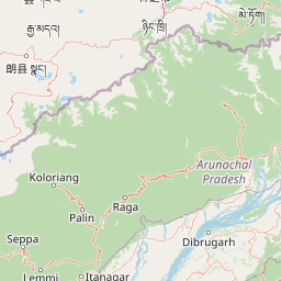
Map view of D'Ering Memorial Wildlife Sanctuary

Use this park location map to pinpoint D'Ering Memorial Wildlife Sanctuary in India, understand its exact geographic position, and read its mapped placement within the surrounding landscape more clearly.

Pigeon | © OpenStreetMap contributors

Location context for D'Ering Memorial Wildlife Sanctuary

Arunachal Pradesh
Park atlas

Compare surrounding regional geography and connected floodplain habitats.

Other Parks and Protected Areas Near D'Ering Memorial Wildlife Sanctuary

Visitors exploring D'Ering Memorial Wildlife Sanctuary can examine other protected areas across the surrounding region. Comparing adjacent lowland reserves and river basin habitats reveals broader ecological patterns in the eastern Himalayan foothills.
Illustration of a landscape with green mountains, a river, bare trees, and a waterfall under a colorful sky
National parkAssam
About 31 km away#1 closest

South

Dibru-Saikhowa National Park: Mapped Protected Landscape and Regional Geography

Explore Assam's protected natural terrain and park boundaries.

Dibru-Saikhowa National Park represents a key protected area, providing valuable insight into the natural geography and landscape context of Assam. As a designated national park, its mapped boundaries and distinct regional setting are crucial for understanding the distribution of conservation lands in northeastern India. Explore the geographic specifics and atlas relevance of Dibru-Saikhowa National Park for a structured view of this protected landscape.

Area
350 km²
Established
1999
IUCN
II
Relief
Lowland
Wildlife reserveAssam
About 46 km away#2 closest

South

Bherjan-Borajan-Padumoni Wildlife Sanctuary: Regional Geography and Protected Forest Map

A fragmented tropical reserve in the Tinsukia district of Assam.

Delve into the geography of Bherjan-Borajan-Padumoni Wildlife Sanctuary, a reserve spanning three distinct forest blocks. Learn how these managed lands function as a vital arboreal refuge in the broader Brahmaputra valley landscape, offering a detailed look at the protected terrain and habitat structure of this northeastern Indian sanctuary.

Area
7.22 km²
Established
1999
IUCN
IV
Relief
Lowland
Wildlife reserveArunachal Pradesh
About 54 km away#3 closest

Northeast

Mehao Wildlife Sanctuary: Geography and Protected Habitat Mapping in Northeast India

A diverse reserve within the Eastern Himalaya biodiversity hotspot.

Mehao Wildlife Sanctuary protects an expansive landscape featuring rare orchid-rich forests and high-altitude lake ecosystems. By preserving terrain that spans subtropical valleys to temperate coniferous ridges, this reserve provides essential habitat for iconic species like the Mishmi takin and red panda. Examine the complex forest layers and geographic features that define this significant Indian protected area.

Area
281.5 km²
Established
1980
IUCN
II
Relief
Mountain
National parkAssam
About 68 km away#4 closest

South

Dehing Patkai National Park: Assam's Extensive Lowland Tropical Rainforest Atlas

Explore mapped boundaries and critical primate habitat.

Dehing Patkai National Park is a vital protected area in Assam, renowned as India's largest contiguous lowland rainforest. This park provides a crucial habitat for diverse species, notably featuring seven primate species including the Hoolock gibbon, and serves as a key elephant reserve. Explore the mapped geography of this unique four-layered tropical forest ecosystem, understanding its ecological significance and protected landscape identity within northeastern India.

Area
231.65 km²
Established
2004
IUCN
II
Relief
Lowland
Wildlife reserveArunachal Pradesh
About 84 km away#5 closest

West

Kane Wildlife Sanctuary: Geography, Forest Mosaics, and Protected Himalayan Terrain

A vital wildlife reserve located in the West Siang district of Arunachal Pradesh.

Kane Wildlife Sanctuary presents a compact yet meaningful protected area defined by its unique transition of tropical evergreen and temperate broadleaf forest types. This Himalayan reserve serves as a critical habitat for large mammals and diverse bird populations, offering a focused look at the varied terrain and regional biodiversity found within the foothills of northeastern India.

Area
31 km²
Established
1991
IUCN
IV
Relief
Upland
National parkArunachal Pradesh
About 91 km away#6 closest

Northwest

Mouling National Park: Explore Arunachal Pradesh National Park Geography and Protected Landscape

Mapped protected areas and regional geographic context.

Mouling National Park in Arunachal Pradesh offers a unique opportunity to explore the mapped boundaries and geographic characteristics of a significant protected landscape. This page provides structured insights into its role as a national park, detailing its regional setting and contributing to a broader atlas of protected areas. Understand the distinct natural terrain and landscape context that define this protected area within India.

Area
483 km²
Established
1986
IUCN
II
Relief
Mountain
National parkArunachal Pradesh
About 105 km away#7 closest

Southeast

Namdapha National Park: A National Park Detailed Entry for Geographic and Atlas Exploration

Explore mapped boundaries and regional landscape context in Arunachal Pradesh.

Namdapha National Park serves as a key protected area, offering a unique opportunity for structured geographic discovery. This entry focuses on its designation as a national park, providing detailed information about its mapped landscape, regional setting within Arunachal Pradesh, and overall protected territory context. It is designed to assist users in understanding the park's boundaries and its significance within a broader atlas framework.

Area
1,985 km²
Established
1983
IUCN
II
Relief
Mountain
Wildlife reserveArunachal Pradesh
About 122 km away#8 closest

North

Yordi Rabe Supse Wildlife Sanctuary: Protected Forest Landscapes and Himalayan Geography

A detailed map and atlas overview of West Siang district terrain

Spanning elevations between 1,500 and 2,500 meters, this wildlife reserve in Arunachal Pradesh acts as a crucial refuge for high-altitude ungulates and rare mammals. The sanctuary offers a unique look at continuous vegetation gradients ranging from tropical canopy to coniferous pine forest, defining the ecological character of this eastern Himalayan mountainous region.

Area
397 km²
Established
1996
IUCN
IV
Relief
Mountain

Common questions about visiting, size, designation, and location context for D'Ering Memorial Wildlife Sanctuary

D'Ering Memorial Wildlife Sanctuary FAQs for park facts, access, geography, and protected area context

Find quick answers about D'Ering Memorial Wildlife Sanctuary, including protected-area facts, park geography, trail and visitor context, and how the park fits into its surrounding country and regional landscape.
MoriAtlas Explorer

Continue Your Protected Areas Search Across the Global Atlas

Deepen your exploration by continuing the structured search for national parks and protected areas worldwide. Utilize the comprehensive filtering capabilities to compare different conservation landscapes and refine your understanding of global park geography. Discover more about the distribution and characteristics of protected natural areas.

Global natural geography