

Mori Atlas logo
Wildlife reserveDibang Wildlife Sanctuary

Tracing the mapped boundaries and high altitude forest geography of the eastern Himalayan region

Dibang Wildlife Sanctuary: A Core Protected Wildlife Reserve in the Arunachal Pradesh Himalayas

Dibang Wildlife Sanctuary encompasses over 4,000 square kilometers of steep ridges and deep river valleys within the Upper Dibang Valley of Arunachal Pradesh. As a cornerstone of the Dihang-Dibang Biosphere Reserve, this protected area features diverse montane forest gradients and critical habitats that support rare endemic species. The rugged terrain provides a vast, continuous wilderness that defines the ecological character of this remote Indian Himalayan landscape.

wildlife sanctuaryeastern HimalayasMishmi Hillsbiodiversityrare mammalsendemic species

Dibang Wildlife Sanctuary

Wildlife reserve

Park overview

Structured park overview, official facts, and landscape profile for Dibang Wildlife Sanctuary

Dibang Wildlife Sanctuary park facts, protected area profile, and essential visitor context

Review the core facts for Dibang Wildlife Sanctuary, including designation, size, terrain, visitor scale, habitats, and operating context in one park-focused overview.

About Dibang Wildlife Sanctuary

Dibang Wildlife Sanctuary is a state-level protected area in the Upper Dibang Valley district of northeastern Arunachal Pradesh, India. Stretching across approximately 4,149 square kilometers of deeply dissected eastern Himalayan terrain, the sanctuary encompasses a substantial portion of the Mishmi Hills landscape, including forested valleys, river systems, and high-elevation ridges that together support one of the most distinctive wildlife assemblages in the Indian Himalayas.

The sanctuary is one of eight wildlife sanctuaries administered by Arunachal Pradesh and is governed by the state's Department of Environment and Forests. It was formally established in 1992 and is internationally classified as an IUCN Category IV habitat and species management area, a designation that emphasizes targeted conservation of particular species and habitats rather than strict wilderness preservation. Importantly, the sanctuary lies fully or partly within the larger Dihang-Dibang Biosphere Reserve, giving it a critical role in landscape-level ecological connectivity across a still relatively undisturbed portion of the eastern Himalayas.

Ecologically, Dibang is best understood as a refuge for rare and range-restricted species associated with the eastern Himalayas and the Mishmi Hills in particular. Its combination of elevation gradients, dense temperate and subtropical forests, and remote setting has allowed several species whose populations have declined elsewhere in the region to persist here. The sanctuary's size and biosphere-reserve context further increase its significance as a long-term reservoir for biodiversity in a part of India where habitat pressures outside protected boundaries are gradually intensifying.

Quick facts and research context for Dibang Wildlife Sanctuary

Dibang Wildlife Sanctuary is a state wildlife sanctuary in the Upper Dibang Valley district of Arunachal Pradesh, India. It was established in 1992 and is managed by the state's Department of Environment and Forests.

The sanctuary covers approximately 4,149 square kilometers, making it one of the larger protected wildlife areas in the state. It lies fully or partly within the Dihang-Dibang Biosphere Reserve and is classified as an IUCN Category IV habitat and species management area, reflecting its focus on conserving specific wildlife populations rather than full ecosystem wilderness.

Protection and recognition

Terrestrial protected area management scope and recognition records

Dibang Wildlife Sanctuary Protection Status and Conservation Data

Dibang Wildlife Sanctuary maintains a documented terrestrial protection scope within its designated conservation boundaries. Available administrative records outline the official management framework and international recognition data for this protected area.

Protection details

Protection scope
Terrestrial
Park context

Deeper park guide and search-rich context for Dibang Wildlife Sanctuary

Dibang Wildlife Sanctuary history, landscape, wildlife, and travel context

Explore Dibang Wildlife Sanctuary through its history, landscape character, ecosystems, wildlife, conservation priorities, cultural context, and seasonal travel timing in a structured park guide built for atlas discovery and search intent.

Why Dibang Wildlife Sanctuary stands out

Dibang Wildlife Sanctuary is best known as a stronghold for rare Mishmi Hills fauna, including the Mishmi takin, red goral, red panda, and at least two species of musk deer, alongside highly localized birds such as Sclater's monal and Blyth's tragopan. It is also notable as the type locality from which the Mishmi Hills giant flying squirrel was described. The sanctuary draws additional recognition from its scale and position within the Dihang-Dibang Biosphere Reserve, where it anchors protection for one of the most biologically distinctive landscapes in the eastern Himalayas.

Dibang Wildlife Sanctuary history and protected-area timeline

Dibang Wildlife Sanctuary was established in 1992 by the Government of Arunachal Pradesh, becoming one of the eight state-level wildlife sanctuaries in the state. Its creation reflected growing recognition of the ecological importance of the Upper Dibang Valley and the broader Mishmi Hills, where extensive tracts of relatively undisturbed eastern Himalayan forest remained.

Over subsequent years, Dibang gained additional conservation weight through its inclusion within the Dihang-Dibang Biosphere Reserve, an umbrella designation that links the sanctuary with surrounding landscapes to strengthen ecological connectivity and coordinated management. The sanctuary has continued to be administered by the Arunachal Pradesh Department of Environment and Forests, and its early-twenty-first-century designation as an IUCN Category IV area formalized its role as a habitat and species management zone rather than a strictly protected wilderness reserve.

Dibang Wildlife Sanctuary landscape and geographic character

The sanctuary occupies a large portion of the Upper Dibang Valley in the eastern Himalayas, a region characterized by steep ridges, deep river valleys, and dense montane forest cover. Elevation gradients within the area shift from lower subtropical river valleys into higher temperate and subalpine environments, producing strong habitat layering across the landscape.

The terrain is shaped by the tributaries of the Dibang River system, which carve through the Mishmi Hills and create a mosaic of forested slopes, gorges, and benches. Natural forest cover remains extensive throughout the sanctuary, with relatively limited human infrastructure, contributing to the continuity of habitat that supports wide-ranging mammals and forest-interior bird species.

Dibang Wildlife Sanctuary ecosystems, habitats, and plant life

Ecologically, Dibang Wildlife Sanctuary falls within the eastern Himalayan broadleaf and mixed forest biomes, with temperate forests dominating the middle elevations and subtropical elements in the lower valleys. The mosaic of habitats supports a diverse community of mammals, birds, and lesser-studied taxa typical of the Mishmi Hills ecosystem.

The sanctuary's position within or adjacent to the Dihang-Dibang Biosphere Reserve places it within a broader ecological network that links high-elevation habitats to lower forested corridors. This connectivity helps maintain the range of vegetation zones that species such as the Mishmi takin, red panda, and several pheasants depend on across seasons and elevations.

Dibang Wildlife Sanctuary wildlife and species highlights

Dibang Wildlife Sanctuary is particularly significant for the rare mammals of the eastern Himalayas. It supports the Mishmi takin, a goat-antelope endemic to this region, as well as the red goral, the Gongshan muntjac, red panda, Asiatic black bear, and at least two species of musk deer. Occasional tiger records also highlight the sanctuary's capacity to sustain large carnivores despite its remote setting.

Among birds, the sanctuary is known for the rare Sclater's monal and Blyth's tragopan, both of which are prized eastern Himalayan species with limited ranges. The forest canopy and high-elevation forests also support a broad community of smaller mammals and forest birds, and the sanctuary has yielded new species descriptions, including the Mishmi Hills giant flying squirrel, which was identified from the edge of the protected area. Together, these species make Dibang one of the most important sites in India for the conservation of Mishmi Hills fauna.

Dibang Wildlife Sanctuary conservation status and protection priorities

The sanctuary is classified as an IUCN Category IV habitat and species management area, indicating that its management framework is oriented toward conserving particular species and their habitats, including species that require active monitoring and protection. Its inclusion within the Dihang-Dibang Biosphere Reserve strengthens this role by embedding the sanctuary in a larger landscape protection strategy.

Dibang's conservation value is amplified by its sheer size and by the relative integrity of its forest cover. The presence of rare and range-restricted species, from Mishmi takin and red goral to Sclater's monal and Blyth's tragopan, gives the sanctuary a national and regional importance for eastern Himalayan biodiversity conservation. Ongoing management by the Arunachal Pradesh Department of Environment and Forests supports this conservation framework at the state level.

Top sights and standout views in Dibang Wildlife Sanctuary

Dibang Wildlife Sanctuary stands out for its combination of scale, ecological intactness, and concentration of rare eastern Himalayan species. Its location within the Mishmi Hills and the Dihang-Dibang Biosphere Reserve ties it directly to one of India's most distinctive high-biodiversity landscapes.

The sanctuary's importance is reinforced by its role as a type locality for the Mishmi Hills giant flying squirrel and as a refuge for iconic species such as the Mishmi takin, red panda, and Blyth's tragopan, placing Dibang among the key protected areas for eastern Himalayan wildlife conservation.

Monthly climate preview

Long-term average temperature and monthly precipitation records for Dibang Wildlife Sanctuary

Dibang Wildlife Sanctuary Climate Normals and Annual Weather Patterns

Dibang Wildlife Sanctuary exhibits recorded monthly mean temperatures ranging from sub-zero winter baselines to milder summer peaks alongside distinct seasonal precipitation shifts. Reviewing the complete twelve-month climate profile provides detailed long-term temperature ranges and precipitation averages across the protected area.
Annual mean7 °C
-1 °C14 °C
Jan-1°
Feb
Mar
Apr
May10°
Jun13°
Jul14°
Aug14°
Sep12°
Oct
Nov
Dec
Warmest month
July

13.8 °C

Coolest month
January

-0.6 °C

Wettest month
July

7.4 mm/day

Driest month
December

0.1 mm/day

Park location guide

Geography guide, regional context, and park location map for Dibang Wildlife Sanctuary

Dibang Wildlife Sanctuary park geography, regions, and map view in India

Understand where Dibang Wildlife Sanctuary sits in India through a broader geographic reading of the surrounding landscape, nearby location context, and its mapped position within the national park landscape.

How Dibang Wildlife Sanctuary fits into India

India is a South Asian country bordered by the Indian Ocean, Arabian Sea, and Bay of Bengal. It shares land borders with Pakistan, China, Nepal, Bhutan, Bangladesh, and Myanmar. The country has a population of over 1.4 billion people and operates as a federal parliamentary republic with its capital in New Delhi.

Wider geography shaping Dibang Wildlife Sanctuary in India

India occupies the Indian subcontinent in South Asia, bordered by the Arabian Sea to the southwest, the Bay of Bengal to the southeast, and the Indian Ocean to the south. It shares land borders with Pakistan to the west, China, Nepal, and Bhutan to the north, and Bangladesh and Myanmar to the east. The territory also includes the Andaman and Nicobar Islands in the Indian Ocean.

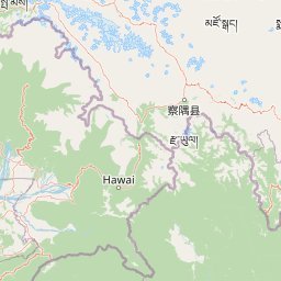
Map view of Dibang Wildlife Sanctuary

Use this park location map to pinpoint Dibang Wildlife Sanctuary in India, understand its exact geographic position, and read its mapped placement within the surrounding landscape more clearly.

Pigeon | © OpenStreetMap contributors

Location context for Dibang Wildlife Sanctuary

Arunachal Pradesh
Park atlas

Compare regional biodiversity and neighboring eastern Himalayan landscapes

Parks Near Dibang Wildlife Sanctuary and Surrounding Protected Areas

Explore other protected areas near Dibang Wildlife Sanctuary to examine shared eastern Himalayan terrain and montane forest habitats. Comparing adjacent reserves provides broader context on regional conservation corridors and high-altitude wildlife distributions.
Wildlife reserveArunachal Pradesh
About 57 km away#1 closest

West

Yordi Rabe Supse Wildlife Sanctuary: Protected Forest Landscapes and Himalayan Geography

A detailed map and atlas overview of West Siang district terrain

Spanning elevations between 1,500 and 2,500 meters, this wildlife reserve in Arunachal Pradesh acts as a crucial refuge for high-altitude ungulates and rare mammals. The sanctuary offers a unique look at continuous vegetation gradients ranging from tropical canopy to coniferous pine forest, defining the ecological character of this eastern Himalayan mountainous region.

Area
397 km²
Established
1996
IUCN
IV
Relief
Mountain
Wildlife reserveArunachal Pradesh
About 100 km away#2 closest

South

Mehao Wildlife Sanctuary: Geography and Protected Habitat Mapping in Northeast India

A diverse reserve within the Eastern Himalaya biodiversity hotspot.

Mehao Wildlife Sanctuary protects an expansive landscape featuring rare orchid-rich forests and high-altitude lake ecosystems. By preserving terrain that spans subtropical valleys to temperate coniferous ridges, this reserve provides essential habitat for iconic species like the Mishmi takin and red panda. Examine the complex forest layers and geographic features that define this significant Indian protected area.

Area
281.5 km²
Established
1980
IUCN
II
Relief
Mountain
National parkArunachal Pradesh
About 104 km away#3 closest

Southwest

Mouling National Park: Explore Arunachal Pradesh National Park Geography and Protected Landscape

Mapped protected areas and regional geographic context.

Mouling National Park in Arunachal Pradesh offers a unique opportunity to explore the mapped boundaries and geographic characteristics of a significant protected landscape. This page provides structured insights into its role as a national park, detailing its regional setting and contributing to a broader atlas of protected areas. Understand the distinct natural terrain and landscape context that define this protected area within India.

Area
483 km²
Established
1986
IUCN
II
Relief
Mountain
Wildlife reserveArunachal Pradesh
About 127 km away#4 closest

South

D'Ering Memorial Wildlife Sanctuary: Mapped Grassland and Floodplain Geography

A vital wildlife reserve within the Arunachal Pradesh landscape.

Spanning 190 square kilometers in the eastern Himalayas, D'Ering Memorial Wildlife Sanctuary is a distinct floodplain reserve characterized by open grasslands and riverine forest patches. The sanctuary serves as a key ecological anchor in the Siang river system, offering a look at managed, low-lying habitats that support predators and small mammals across the plains of Arunachal Pradesh.

Area
190 km²
Established
1978
IUCN
IV
Scope
Terrestrial
Illustration of a landscape with green mountains, a river, bare trees, and a waterfall under a colorful sky
National parkAssam
About 158 km away#5 closest

South

Dibru-Saikhowa National Park: Mapped Protected Landscape and Regional Geography

Explore Assam's protected natural terrain and park boundaries.

Dibru-Saikhowa National Park represents a key protected area, providing valuable insight into the natural geography and landscape context of Assam. As a designated national park, its mapped boundaries and distinct regional setting are crucial for understanding the distribution of conservation lands in northeastern India. Explore the geographic specifics and atlas relevance of Dibru-Saikhowa National Park for a structured view of this protected landscape.

Area
350 km²
Established
1999
IUCN
II
Relief
Lowland
Wildlife reserveAssam
About 173 km away#6 closest

South

Bherjan-Borajan-Padumoni Wildlife Sanctuary: Regional Geography and Protected Forest Map

A fragmented tropical reserve in the Tinsukia district of Assam.

Delve into the geography of Bherjan-Borajan-Padumoni Wildlife Sanctuary, a reserve spanning three distinct forest blocks. Learn how these managed lands function as a vital arboreal refuge in the broader Brahmaputra valley landscape, offering a detailed look at the protected terrain and habitat structure of this northeastern Indian sanctuary.

Area
7.22 km²
Established
1999
IUCN
IV
Relief
Lowland
National parkArunachal Pradesh
About 183 km away#7 closest

South

Namdapha National Park: A National Park Detailed Entry for Geographic and Atlas Exploration

Explore mapped boundaries and regional landscape context in Arunachal Pradesh.

Namdapha National Park serves as a key protected area, offering a unique opportunity for structured geographic discovery. This entry focuses on its designation as a national park, providing detailed information about its mapped landscape, regional setting within Arunachal Pradesh, and overall protected territory context. It is designed to assist users in understanding the park's boundaries and its significance within a broader atlas framework.

Area
1,985 km²
Established
1983
IUCN
II
Relief
Mountain
Wildlife reserveArunachal Pradesh
About 189 km away#8 closest

Southwest

Kane Wildlife Sanctuary: Geography, Forest Mosaics, and Protected Himalayan Terrain

A vital wildlife reserve located in the West Siang district of Arunachal Pradesh.

Kane Wildlife Sanctuary presents a compact yet meaningful protected area defined by its unique transition of tropical evergreen and temperate broadleaf forest types. This Himalayan reserve serves as a critical habitat for large mammals and diverse bird populations, offering a focused look at the varied terrain and regional biodiversity found within the foothills of northeastern India.

Area
31 km²
Established
1991
IUCN
IV
Relief
Upland

Common questions about visiting, size, designation, and location context for Dibang Wildlife Sanctuary

Dibang Wildlife Sanctuary FAQs for park facts, access, geography, and protected area context

Find quick answers about Dibang Wildlife Sanctuary, including protected-area facts, park geography, trail and visitor context, and how the park fits into its surrounding country and regional landscape.
MoriAtlas Explorer

Continue Your Protected Areas Search Across the Global Atlas

Deepen your exploration by continuing the structured search for national parks and protected areas worldwide. Utilize the comprehensive filtering capabilities to compare different conservation landscapes and refine your understanding of global park geography. Discover more about the distribution and characteristics of protected natural areas.

Global natural geography