Mori Atlas logo
Nature reserveDolina Kłodawy Nature Reserve

A botanical river gorge habitat mapped across the glacial moraine of Northern Poland

Dolina Kłodawy Nature Reserve and the Protected Landscapes of the Pomeranian Voivodeship

(Rezerwat przyrody Dolina Kłodawy)

Dolina Kłodawy Nature Reserve preserves a linear river gorge cut through the glacial terrain of the Kashubian Lake District in the Pomeranian Voivodeship. This protected area features a distinct ecological transition from ash-alder floodplain forests on the damp valley floor to oak-hornbeam woodland on the surrounding slopes. Beyond its narrow boundaries, the reserve serves as a significant botanical site known for sub-montane plant communities situated far from their typical geographic range.

forest reserveriver gorgefloodplain forestash-alder woodlandoak-hornbeam forestbotanical reserve

Dolina Kłodawy Nature Reserve

Nature reserve

Park overview

Structured park overview, official facts, and landscape profile for Dolina Kłodawy Nature Reserve

Dolina Kłodawy Nature Reserve park facts, protected area profile, and essential visitor context

Review the core facts for Dolina Kłodawy Nature Reserve, including designation, size, terrain, visitor scale, habitats, and operating context in one park-focused overview.

About Dolina Kłodawy Nature Reserve

Dolina Kłodawy Nature Reserve is a small but ecologically focused protected area in northern Poland, situated in the wooded morainic landscape of the Kashubian Lake District, not far from Gdańsk. The reserve was established in 1999 to preserve a comparatively short but ecologically distinctive section of the Kłodawa stream, a tributary of the Motława, where the river has cut a narrow gorge through hills of glacial origin. The entire protected stretch is only about 1.6 kilometres long, yet within that distance it concentrates two contrasting forest communities that are characteristic of well-preserved lowland river valleys in this part of Poland.

The bottom of the valley is occupied by ash-alder floodplain woodland, a wet forest community shaped by seasonal high water and nutrient-rich alluvial soils. On the slopes flanking the gorge, fragments of oak-hornbeam forest (grąd) survive, representing the drier, more stable woodland typical of the surrounding moraine uplands. The juxtaposition of these two communities within a few hundred metres of each other gives the reserve much of its botanical significance, and helps explain why a site of only around 10 hectares has been deemed worthy of strict protection.

Beyond its Polish legal designation, the reserve holds additional recognition within the European Natura 2000 network under the same name, underscoring its importance for the conservation of habitat types that have become rare or fragmented across the wider lowland landscape of northern Europe. The reserve is administered by the Regional Nature Conservation Officer in Gdańsk, and is managed as part of the Kolbudy Forest District.

Quick facts and research context for Dolina Kłodawy Nature Reserve

Dolina Kłodawy is a forest nature reserve in Pomeranian Voivodeship, Poland, situated within Gmina Trąbki Wielkie and the Kashubian Lake District mesoregion. It was created in 1999 under the legal act published in the official journal of the Pomeranian Voivodeship, and is managed by the Regional Nature Conservation Officer in Gdańsk under the Kolbudy Forest District.

The reserve covers a 1.6 kilometre stretch of the Kłodawa river gorge through moraine hills, enclosing ash-alder floodplain forest in the valley bottom and fragments of oak-hornbeam forest on the slopes. Active protection measures apply under a management plan established in 2012, and the site is also recognised as the Natura 2000 habitat area known as Dolina Kłodawy PLH220007.

Protection and recognition

Documented terrestrial protection scope, designation year, and management framework

Dolina Kłodawy Nature Reserve Protection Status and Designation History

Dolina Kłodawy Nature Reserve maintains a documented terrestrial protection status established in 1999. Structured records organize the official designation history and conservation framework associated with the protected landscape.

Protection details

Protection scope
Terrestrial
Designated year
1999
Transboundary protection
No
Buffer area
0.15 km²
Park context

Deeper park guide and search-rich context for Dolina Kłodawy Nature Reserve

Dolina Kłodawy Nature Reserve history, landscape, wildlife, and travel context

Explore Dolina Kłodawy Nature Reserve through its history, landscape character, ecosystems, wildlife, conservation priorities, cultural context, and seasonal travel timing in a structured park guide built for atlas discovery and search intent.

Why Dolina Kłodawy Nature Reserve stands out

The reserve is best known for protecting a small but botanically rich ash-alder floodplain forest (łęg jesionowo-olszowy) in the floor of the Kłodawa river gorge, set against moraine hills of the Kashubian Lake District. Its particular distinction lies in the mix of strictly protected plant species and a remarkable presence of mountain and sub-montane plants far from their usual range, including monkshood, mountain speedwell, fringed meadow saxifrage and mountain thlaspi.
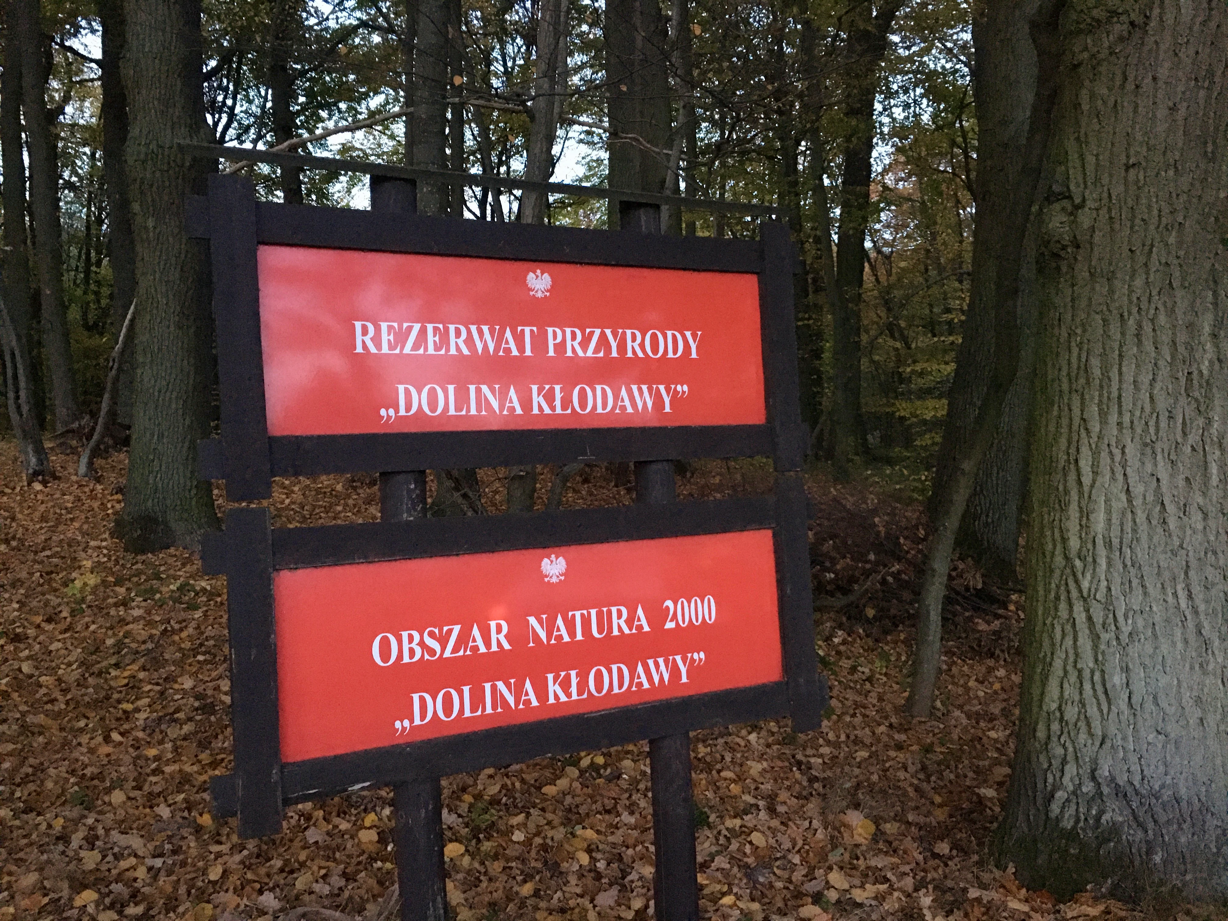
A wooden signpost in a forest featuring two red rectangular signs with white text reading 'REZERWAT PRZYRODY DOLINA KŁODAWY' and 'OBSZAR NATURA 2000 DOLINA KŁODAWY'.
Official signage marking the Dolina Kłodawy Nature Reserve and Natura 2000 area.

Dolina Kłodawy Nature Reserve history and protected-area timeline

The reserve was formally created in 1999 through a legal act published in the official journal of the Pomeranian Voivodeship, reflecting a period in which Poland significantly expanded its network of small forest and habitat reserves. Its establishment came as recognition of the botanical value of the Kłodawa gorge, which had already attracted scientific attention for its combination of floodplain and oak-hornbeam forest communities.

In 2012, an official protection plan was adopted for the area, defining active conservation measures to be applied within the reserve. Following its national designation, the reserve was also recognised at the European level through inclusion in the Natura 2000 network, with the same boundaries forming the special area of conservation known as Dolina Kłodawy PLH220007.

Dolina Kłodawy Nature Reserve landscape and geographic character

The landscape of Dolina Kłodawy is shaped by the geomorphological character of the Kashubian Lake District, a region built up by successive glaciations that left behind rolling moraine hills, kettle hollows and a network of streams dissecting the upland. The reserve covers a narrow, roughly 1.6 kilometre gorge cut by the Kłodawa stream through one of these moraine ridges, giving the protected area a clearly linear form that follows the river valley.

The valley floor is flat, damp and prone to seasonal flooding, with soft alluvial soils supporting the characteristic ash-alder floodplain forest. The slopes rise steeply on either side, exposing glacial deposits and supporting oak-hornbeam woodland on more stable ground. The broader scenery outside the reserve is typical of the Kashubian Lake District: a mosaic of post-glacial lakes, interspersed forests, agricultural land, and small rural settlements such as the nearby villages of Kleszczewo and Trąbki Wielkie.

Dolina Kłodawy Nature Reserve ecosystems, habitats, and plant life

The reserve is ecologically significant not for its size but for the integrity and contrast of its forest communities. The valley floor carries a well-developed ash-alder floodplain forest, dominated by ash and alder and shaped by the wet conditions along the stream. This type of woodland has become increasingly rare across the Polish lowlands because of drainage, river regulation and agricultural conversion. Its persistence here within an actively protected gorge gives the reserve a disproportionate conservation value.

The slopes surrounding the gorge support fragments of oak-hornbeam forest, a community typical of more stable, well-drained lowland sites, and the border between the wet floodplain community below and the drier oak-hornbeam woodland above creates a steep ecological gradient within a very short distance. The reserve lies within the forest management unit of Nadleśnictwo Kolbudy, and its conservation framework combines its Polish nature reserve status with full alignment to the European Natura 2000 habitat area of the same name.

Dolina Kłodawy Nature Reserve wildlife and species highlights

The source material centers almost entirely on botanical interest, and the reserve's name and management framing reflect this, with explicit focus on rare plant communities rather than fauna. While the mixed ash-alder and oak-hornbeam forest mosaic provides habitat for typical lowland forest birdlife and small mammals associated with riparian and deciduous woodland in this part of Poland, the reserve itself is chiefly documented and recognised for its flora, including strictly protected species such as broad-leaved helleborine, northern wolf's-bane and mezereon, alongside several mountain and sub-montane plants that are unusual in the lowlands.

Dolina Kłodawy Nature Reserve conservation status and protection priorities

The conservation purpose of Dolina Kłodawy is to safeguard a representative and increasingly rare example of a river gorge forest system in the Kashubian Lake District, protecting both the physical structure of the moraine-cut valley and its characteristic vegetation. Its designation as a Polish forest nature reserve under active protection reflects the recognition that surviving examples of ash-alder floodplain forest, in combination with oak-hornbeam woodland on the slopes, need deliberate management to resist degradation from hydrological change, excessive browsing or successional shifts.

The reserve also forms part of the European Natura 2000 network as the habitat site Dolina Kłodawy PLH220007, covering the same boundaries as the national reserve. This double designation places the site within the framework of the European Union's Habitats Directive, reinforcing the importance of its habitat types for the wider continental conservation effort and tying the local management plan adopted in 2012 into broader European reporting and monitoring obligations.

Top sights and standout views in Dolina Kłodawy Nature Reserve

A short but ecologically rich stretch of river gorge in the Kashubian Lake District, protecting an unusual juxtaposition of ash-alder floodplain forest on the valley floor and oak-hornbeam woodland on the surrounding moraine slopes. Notable for the presence of strictly protected species and a remarkable set of mountain and sub-montane plants far from their typical range. Recognised both as a Polish nature reserve and as a Natura 2000 habitat site, with the same boundaries used for both designations.
Monthly climate preview

Long-term monthly temperature and precipitation data for Pomeranian Voivodeship

Dolina Kłodawy Nature Reserve Climate Normals and Temperature Rhythm

Dolina Kłodawy Nature Reserve tracks monthly climate normals from 1991 to 2020, recording shifts in average temperature and precipitation across a representative point. Reviewing the complete twelve-month profile provides deeper context on measured thermal ranges and long-term weather patterns.
Annual mean8 °C
-3 °C19 °C
Jan-3°
Feb-2°
Mar
Apr
May13°
Jun17°
Jul19°
Aug19°
Sep14°
Oct
Nov
Dec-1°
Warmest month
July

19.1 °C

Coolest month
January

-2.9 °C

Wettest month
July

2.5 mm/day

Driest month
April

1.3 mm/day

Park location guide

Geography guide, regional context, and park location map for Dolina Kłodawy Nature Reserve

Dolina Kłodawy Nature Reserve park geography, regions, and map view in Poland

Understand where Dolina Kłodawy Nature Reserve sits in Poland through a broader geographic reading of the surrounding landscape, nearby location context, and its mapped position within the national park landscape.

How Dolina Kłodawy Nature Reserve fits into Poland

Poland, officially the Republic of Poland, is a Central European country spanning from the Baltic Sea in the north to the Carpathian Mountains in the south. It borders Germany, Czech Republic, Slovakia, Ukraine, Belarus, Lithuania, and Kaliningrad Oblast. The country has a temperate climate, diverse landscapes, and is known for its rich history, cultural heritage, and strong economic position within the EU.

Wider geography shaping Dolina Kłodawy Nature Reserve in Poland

Poland occupies 312,696 km2 in Central Europe, extending from the Baltic Sea coast in the north to the Sudetes and Carpathian Mountains in the south. It borders Germany to the west, Czech Republic and Slovakia to the south, Ukraine and Belarus to the east, and Lithuania and Kaliningrad Oblast to the northeast. The landscape includes lowland plains, uplands, and mountain ranges.

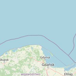
Map view of Dolina Kłodawy Nature Reserve

Use this park location map to pinpoint Dolina Kłodawy Nature Reserve in Poland, understand its exact geographic position, and read its mapped placement within the surrounding landscape more clearly.

Pigeon | © OpenStreetMap contributors

Location context for Dolina Kłodawy Nature Reserve

Pomeranian Voivodeship

Visual reference collection showcasing river gorge terrain and forest habitats

Dolina Kłodawy Nature Reserve Landscape, Scenery, and Protected Area Photos

Photographs capture the narrow river gorge, glacial moraine hills, and diverse forest communities that define the protected landscape. Visual documentation reveals the distinct terrain features, seasonal valley floor conditions, and botanical habitats preserved within the reserve.

A wooden signpost in a forest featuring two red rectangular signs with white text reading 'REZERWAT PRZYRODY DOLINA KŁODAWY' and 'OBSZAR NATURA 2000 DOLINA KŁODAWY'.

Park atlas

Compare adjacent forest reserves and glacial landscapes across the surrounding region

Parks Near Dolina Kłodawy Nature Reserve And Regional Protected Areas

Browsing parks near Dolina Kłodawy Nature Reserve reveals similar forest reserves and river gorges situated across the Kashubian Lake District. Expanding the geographic comparison highlights related protected landscapes and regional conservation areas.
Nature reserveGdańsk
About 16 km away#1 closest

North

Zbiornik Wody Stara Orunia: A Protected Industrial Heritage Site and Nature Reserve in Gdańsk

Historic brick architecture meeting urban bat conservation zones

Built in 1869, this historic underground reservoir in the Orunia district of Gdańsk combines rare Prussian engineering with a vital role as a Natura 2000 protected habitat. The site serves as a key component of the regional water trail, offering a look into the complex relationship between industrial infrastructure, urban landscape development, and the protection of essential wildlife hibernation cycles.

Area
0.001 km²
Established
1869
Relief
Upland
Climate
Temperate
Nature reservePomeranian Voivodeship
About 19 km away#2 closest

North

Dolina Strzyży Nature Reserve Protected Forest and Stream Valley Geography

Natural riparian forest in Pomeranian Voivodeship

Explore the geographic profile of Dolina Strzyży Nature Reserve, a protected valley woodland in the Pomeranian Voivodeship of Poland. This reserve maintains dense oak-hornbeam habitats and stream-side ecosystems, functioning as a vital green connection between urban Gdańsk and the expansive Trójmiejski Park Krajobrazowy, preserving historic forest remnants.

Area
0.385 km²
Established
2007
Relief
Upland
Climate
Temperate
A wide panoramic watercolor illustration showing a pastoral landscape with green rolling hills, a winding river, scattered trees, and a soft sky with pink and yellow hues.
Protected areaPomeranian Voivodeship
About 25 km away#3 closest

North

Twierdza Wisłoujście Protected Area: Coastal Geography and Historical Mapping in Gdańsk

A historic Baltic fortification and vital ecological site in Pomeranian Voivodeship.

Explore the layered masonry and water-influenced landscape of Twierdza Wisłoujście, a coastal fortress established on the delta of the Vistula River. This site bridges the history of maritime defense and modern ecological conservation as a designated Natura 2000 area. Examine how shifting river channels and centuries of construction define the current defensive perimeters and moated surroundings within the Pomeranian Voivodeship.

Established
1482
Relief
Lowland
Climate
Temperate
Access
Easy access
Protected landscapePomeranian Voivodeship
About 27 km away#4 closest

North

Trójmiejski Park Krajobrazowy: Protected Landscape and Glacial Geography in Pomerania

Exploring the forested moraine upland near the Baltic coast

Covering nearly 20,000 hectares, Trójmiejski Park Krajobrazowy forms an essential green belt along the Kashubian moraine. Its terrain is defined by dramatic erosion, including 80-meter deep ravines and extensive pine-beech forests that host rare relic plant species and protected peatland habitats.

Area
199.3 km²
Established
1979
Relief
Upland
Climate
Temperate
A soft watercolor painting of a marshy coastal landscape with tall grasses, calm water, and distant dunes under a bright, clear sky.
Nature reservePomeranian Voivodeship
About 33 km away#5 closest

Northeast

Rezerwat przyrody Mewia Łacha: Protected Coastal Geography and Vistula Estuary Map

Dynamic Baltic sandbars and migratory bird habitat in Pomerania

Rezerwat przyrody Mewia Łacha occupies a vital coastal strip where river discharge meets the Gulf of Gdańsk. This nature reserve serves as an essential site for migratory waterfowl and nesting terns, defined by its shifting sandbars, dune slacks, and brackish pools. It stands as a key example of the varied estuarine geography found within the Pomeranian Voivodeship.

Area
1.505 km²
Established
1991
Relief
Lowland
Climate
Temperate
A horizontal watercolor illustration showing a gentle river landscape with soft green meadows, trees, and rolling hills in the background.
Nature reservePomeranian Voivodeship
About 33 km away#6 closest

North

Kacze Łęgi Nature Reserve: Mapped Protected Woodland and River Valley Geography

Riparian floodplain forest in the Pomeranian Voivodeship of Poland

Kacze Łęgi functions as a crucial nature reserve that maintains an unusually well-preserved fragment of elm and alder floodplain forest. Nestled along the Kacza River valley in Gdynia, this site offers a concentrated look at the original vegetation of Baltic river valleys. It remains a key component of the regional protected landscape, providing a deep study of moisture-loving woodland within the larger context of the Pomeranian coastal lowlands.

Area
0.09 km²
Established
1983
Relief
Lowland
Scope
Terrestrial
Nature reservePomeranian Voivodeship
About 36 km away#7 closest

Southwest

Mechowisko Krag Nature Reserve: Mapping the Protected Peatlands of the Pomeranian Voivodeship

A specialized alkaline fen within the Bory Tucholskie forest region

Mechowisko Krag Nature Reserve serves as a key site for wetland conservation in Poland. This protected landscape preserves a rare alkaline peatland that sustains diverse moss communities and rare vascular flora, including bog Saxifrage, while providing shelter for wetland birds within the expansive Bory Tucholskie forest region.

Area
0.038 km²
Established
2016
Relief
Lowland
Scope
Terrestrial
Nature reservePomeranian Voivodeship
About 44 km away#8 closest

Northwest

Rezerwat przyrody Jezioro Turzycowe: Wetland Protected Area in Pomeranian Voivodeship

Kashubian Lake District bog forest and dystrophic lake atlas

Rezerwat przyrody Jezioro Turzycowe protects a concentrated mosaic of post-glacial wetland environments, including a dystrophic lake and raised bog habitats. This nature reserve offers deep insight into the specific hydrological and botanical conditions defining northern Polish wilderness corridors.

Area
0.114 km²
Established
1959
Relief
Upland
Climate
Temperate

Common questions about visiting, size, designation, and location context for Dolina Kłodawy Nature Reserve

Dolina Kłodawy Nature Reserve FAQs for park facts, access, geography, and protected area context

Find quick answers about Dolina Kłodawy Nature Reserve, including protected-area facts, park geography, trail and visitor context, and how the park fits into its surrounding country and regional landscape.
MoriAtlas Explorer

Continue Your Protected Areas Search Across the Global Atlas

Deepen your exploration by continuing the structured search for national parks and protected areas worldwide. Utilize the comprehensive filtering capabilities to compare different conservation landscapes and refine your understanding of global park geography. Discover more about the distribution and characteristics of protected natural areas.

Global natural geography