
Mori Atlas logo
Protected landscapeDolina Wapienicy

Mapping the near-natural Carpathian forest zones and diverse river valley terrain

Dolina Wapienicy: A Protected Landscape within the Silesian Voivodeship Mountain Ridges

(Zespół przyrodniczo-krajobrazowy "Dolina Wapienicy" (Park Ekologiczny Dolina Wapienicy))

Dolina Wapienicy stands as a significant protected landscape set between the Błatnia and Klimczok-Szyndzielnia mountain ridges in the Silesian Voivodeship. This valley serves as a critical example of urban-adjacent wilderness, where Carpathian beech and mixed montane forests thrive along the Wapienica River. The terrain showcases steep slopes, rock outcrops, and a layered sequence of vegetation zones that highlight the unique ecological character of this southern Polish region.

urban-adjacent wildernessCarpathian beech forestlower montane forestupper montane spruce forestriver valleymountain ridge walking
A flat vector illustration of a concrete dam structure surrounded by a dense forest, with the reflection of the landscape visible in the water below.

Dolina Wapienicy

Protected landscape

Park overview

Structured park overview, official facts, and landscape profile for Dolina Wapienicy

Dolina Wapienicy park facts, protected area profile, and essential visitor context

Review the core facts for Dolina Wapienicy, including designation, size, terrain, visitor scale, habitats, and operating context in one park-focused overview.

About Dolina Wapienicy

Dolina Wapienicy occupies a privileged geographical position at the intersection of Carpathian mountain systems and a major urban conurbation. It lies within the administrative limits of Bielsko-Biała, almost entirely inside two city districts: Wapienica on the western side and Kamienica on the eastern side. Although it is forested mountain terrain in character, the valley is functionally a green core of a city of several hundred thousand people. This unusual juxtaposition, wilderness within a metropolitan area, is one of the defining identity features of the area and a major reason for its national conservation significance.

Geographically, Dolina Wapienicy stretches between two principal mountain ridges of the northern Silesian Beskids. To the east lies the Błatnia range, with peaks such as Palenica, Kopany, Wysokie, Przykra, Błatnia, and Stołów. To the west rises the Klimczok and Szyndzielnia range, crowned by Trzy Kopce, Klimczok, Szyndzielnia, Cuberniok, and Dębowiec. The valley itself is drained by the Wapienica River and its tributaries Barbara, Błatnia, and the well-known Żydowski Stream. The hydrology of the valley was significantly altered in the early twentieth century by the construction of the Mościcki Dam, which created the artificial Wielka Łąka Lake that now forms one of the area's most recognizable landmarks.

Ecologically, the valley is a textbook example of preserved Carpathian forest zonation. The lower elevations support ash-alder floodplain forests and patches of Carpathian alder wetland communities with grey alder, crack willow, and black alder. The mid-elevations are dominated by fertile Carpathian beech forest, where European beech forms the backbone of the canopy and is accompanied by sycamore maple, ash, spruce, and elm. The upper slopes are cloaked in mixed fir-spruce and ultimately in spruce-dominated upper montane forests, an unusually low-altitude occurrence of this belt in the Western Beskids. The natural character of these forests is complemented by sandstone outcrops, landslide caves, rock shelters, and the mysterious "Diable Młyny" site, all contributing to a varied land surface that supports both ecological and aesthetic value.

The cultural layer of the valley is unusually rich. In the early nineteenth century, Luiza Sułkowska, wife of the Bielsko Duke Jan Sułkowski, popularized the valley through her frequent walks and inspired early protection of around 700 hectares of forest. The valley was historically known by her name ("Dolina Luizy") until the second half of the twentieth century. The area later attracted hotels, villas, and tourist infrastructure, while still remaining a reservoir of raw nature. A pre-Celtic hillfort on Palenica, nineteenth-century buildings including the former Sułkowski hunting lodge "Barbara", and the wilma Mościcki Dam together form a layered heritage that complements the natural value of the landscape.

Quick facts and research context for Dolina Wapienicy

Dolina Wapienicy is a landscape and nature protection complex ("zespół przyrodniczo-krajobrazowy") located inside the city of Bielsko-Biała in the Silesian Voivodeship of southern Poland. Established in 1993, it was the first such complex in Poland created as an "ecological park", combining nature protection with environmental education. The protected area covers approximately 1,519 hectares in the northern Silesian Beskids between the Błatnia range and the Klimczok-Szyndzielnia range. The valley sits within both the Silesian Beskids Landscape Park and the Natura 2000 site "Beskid Śląski" PLH240005, and includes two dedicated nature reserves: Stok Szyndzielni (1953) and Jaworzyna (2003).

Protection and recognition

Examine the documented protection status and management scope of Dolina Wapienicy.

Dolina Wapienicy Protection Status and Terrestrial Conservation Scope

Terrestrial protection status and designation details provide structured context for Dolina Wapienicy within the protected area network. Conservation records outline management scope and official recognition parameters without external attribution.

Protection details

Protection scope
Terrestrial
Transboundary protection
No
Park context

Deeper park guide and search-rich context for Dolina Wapienicy

Dolina Wapienicy history, landscape, wildlife, and travel context

Explore Dolina Wapienicy through its history, landscape character, ecosystems, wildlife, conservation priorities, cultural context, and seasonal travel timing in a structured park guide built for atlas discovery and search intent.

Why Dolina Wapienicy stands out

Dolina Wapienicy is best known for preserving large stretches of near-natural Carpathian beech and mixed montane forest within the urban limits of Bielsko-Biała. Its lower and upper montane forest belts, rare for lowland Silesian Beskids slopes, are unusually well protected, and the valley hosts more than 400 vascular plant species, including protected species such as Martagon lily, snowdrops, and various gentians. The area is also notable for combining statutory conservation with a clear educational focus as one of Poland's first ecological parks. Equally distinctive is the valley's wildlife diversity relative to its urban setting. The protected landscape harbors deer, wild boar, foxes, martens, stoats, and bats, alongside more than 60 bird species including high-mountain specialists such as the ring ouzel, the Eurasian nutcracker, the water pipit, the three-toed woodpecker, and even the very rare western capercaillie.
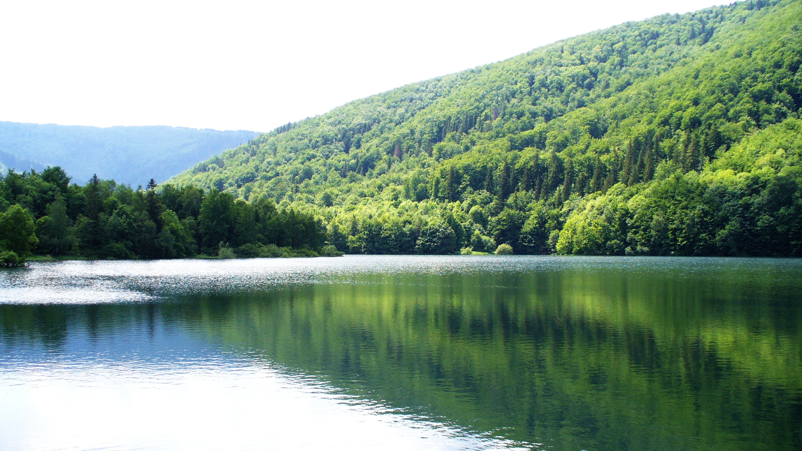
A wide, calm reservoir reflecting the dense green hills and forest that surround it, under bright daylight.
The Wielka Laka reservoir nestled within the lush forested valley of Dolina Wapienicy.

Dolina Wapienicy history and protected-area timeline

Until the eighteenth century, Dolina Wapienicy was largely unknown and not significantly visited. Its landscape qualities were first recognized by Luiza Sułkowska (1788-1848), wife of the Bielsko Duke Jan Sułkowski, who regularly came to the valley for walks. Inspired perhaps by her, the duke ordered the protection of roughly 700 hectares of forest in the valley in the early 1830s, an unusually early act of conservation for the region. The valley was known as "Dolina Luizy", after her, until the second half of the twentieth century.

In the second half of the nineteenth century, the valley gained popularity. Villas and hotels were built, including the famed "Klimczokówka", and by 1927 an autobus connection with Bielsko existed. Important public infrastructure soon followed: the first spring-fed water intakes for the emerging Bielsko waterworks were built in 1893-1894, and by 1911 plans were drawn up to dam the Wapienica River. Construction of the Mościcki Dam, the largest investment in the history of the Bielsko waterworks, was carried out between 1928 and 1932, later expanded during World War II. The dam created the artificial lake Wielka Łąka that now anchors the lower valley landscape.

The valley's modern administrative identity was shaped by the incorporation of its villages into Bielsko-Biała between 1968 (eastern part, Kamienica) and 1977 (western part, Wapienica). Its protected status emerged from a long civic campaign led by the Pracownia na rzecz Wszystkich Istot (Workshop for All Beings). On 13 September 1990 the Bielsko-Biała City Council declared the creation of an ecological park in the valley to be necessary, and in 1993 the same council formally established the "Dolina Wapienicy" natural and landscape complex as the first ecological park in Poland. Since 1998, the valley has also been part of the larger Silesian Beskids Landscape Park.

Dolina Wapienicy landscape and geographic character

The physical landscape of Dolina Wapienicy is shaped by two closely flanking ridges of the northern Silesian Beskids. On one side rises the Błatnia range, with peaks including Palenica (688 m), Kopany, Wysokie, Przykra, Błatnia, and Stołów. On the other side stands the Klimczok and Szyndzielnia range, marked by Trzy Kopce, Klimczok, Szyndzielnia, Cuberniok, and Dębowiec. Between these ridges runs the long, forested valley drained by the Wapienica River and its tributaries.

The terrain expresses a varied relief: steep, sometimes landslide-prone slopes, sandstone outcrops and rock shelters, and small landslide-origin caves. One remarkable feature is the "Diable Młyny" grove, associated with sandstone formations and local folklore about mysterious powers. The hydrological backbone of the valley is the Wapienica River, joined by streams such as Barbara, Błatnia, and the Żydowski Stream, the last of which is particularly important for the location of monumental trees. The Wielka Łąka Lake, created by the Mościcki Dam, introduces a calm horizontal element among the slopes and serves as both a visual landmark and a focal point for visitors.

The mosaic of slopes, ridges, watercourses, and rock exposures supports a finely gradated sequence of altitudinal vegetation belts: submontane zones at the bottom, lower montane forests in the middle, and upper montane spruce forests at the highest elevations. Although the absolute altitudes do not reach the typical Carpathian upper montane belt, the presence of upper montane spruce communities here is unusual and signals the local climatic and geological character of the area.
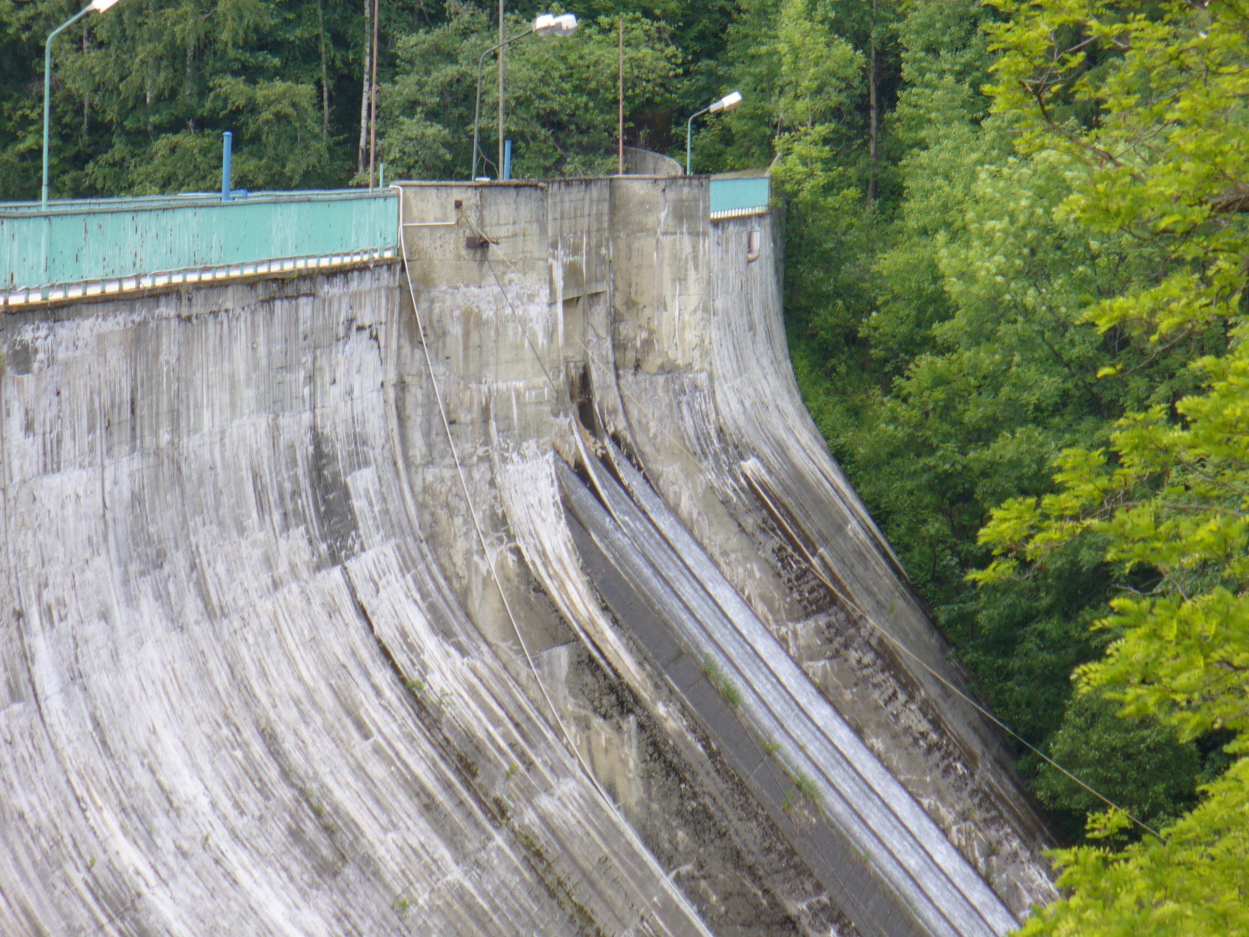
A close up view of the curved, weathered concrete wall of the Wapienica Dam, surrounded by lush green trees.
The concrete dam structure within the Dolina Wapienicy area.

Dolina Wapienicy ecosystems, habitats, and plant life

Dolina Wapienicy is fundamentally a forested valley, and its ecological identity rests on the unusually good preservation of its natural forest communities. The vast majority of the forest stands retain their natural species composition and structure, deviating only mildly from their pristine state. The forest cover reflects the full altitudinal zonation of the Silesian Beskids, with submontane communities in the valley floor, lower montane communities on the mid-slopes, and upper montane communities on the highest ridges.

In the valley floor and along unregulated streams, submontane ash-alder floodplain forests thrive where periodic flooding continuously renews nutrient supply. Slightly higher, fragments of Carpathian alder wetlands with grey alder, crack willow, and black alder add diversity. The mid-slopes are dominated by fertile Carpathian beech forest, with European beech as the principal species accompanied by sycamore maple, ash, spruce, and elm. In the Dolina Wapienicy, ash plays a strikingly rare role among lower montane communities of the Western Beskids, and the forest floor is unusually carpeted by the perennial honesty (Lunaria rediviva). Upper slopes and ridge tops carry acidophilic beech forest, mixed fir-spruce stands, and at the highest parts of the valley, spruce-dominated upper montane forest.

The flora is exceptionally rich for such a small area. The valley hosts more than 400 vascular plant species, of which 21 are fully or partially protected. Notable species include the stemless carline thistle, common snowdrop, Martagon lily, doronicum, clubmosses, bird's-nest orchid, green hellebore, wood meadowsweet, alpine bistort, cross gentian, perennial honesty, mezereon, oxlip, and the protected fern Diplazium sibiricum. The valley also contains monumental trees of impressive size, especially along the Żydowski Stream, where the largest specimen, with three fused trunks, measures 500 cm in circumference. A pine allée of eastern white pines stands near the foot of Stołów.
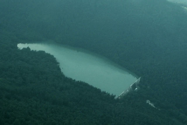
An aerial photograph shows a water reservoir nestled within a dense forest, with a prominent dam structure visible at one end.
Aerial view of the dam reservoir in the Wapienica Valley.

Dolina Wapienicy wildlife and species highlights

The wildlife of Dolina Wapienicy is typical of the Silesian Beskids but unusually rich given the valley's proximity to urban areas. Common Carpathian ungulates such as roe deer, red deer, and wild boar are well established, alongside carnivores including red foxes, martens, and stoats. Bats also inhabit the valley, benefiting from the extensive forest cover, caves, rock shelters, and old buildings that provide roosting sites.

Birds are particularly notable, with more than 60 species observed in the valley. Alongside the typical forest bird assemblage, the area supports high-mountain specialists whose presence here reflects the local upper montane character. These include the ring ouzel, the Eurasian nutcracker, the water pipit, the three-toed woodpecker, and the western capercaillie, one of Europe's rarest and most threatened grouse species. The combination of low-, mid-, and upper-montane habitats in a single relatively small area provides unusually diverse bird niches.

In addition to mammals and birds, the valley supports a varied community of insects, amphibians, and reptiles. The presence of clean, partially unregulated streams, decaying wood, and structurally diverse forests provides stable habitat for species sensitive to disturbance, contributing to the overall ecological value of the protected area.
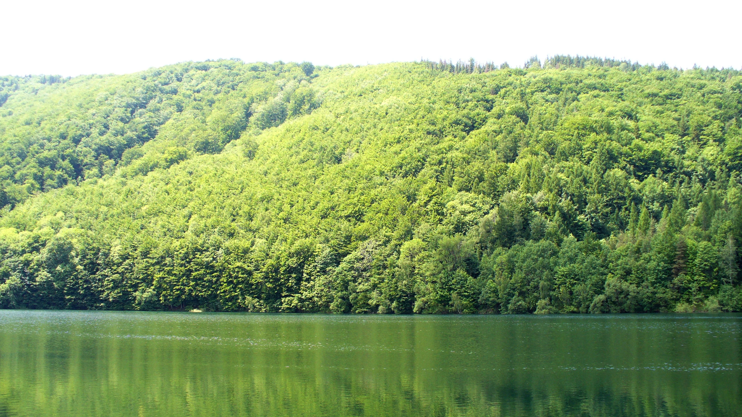
A calm, dark green reservoir surrounded by a dense, vibrant green forested hillside under a bright sky.
The Wielka Laka reservoir in Dolina Wapienicy.

Dolina Wapienicy conservation status and protection priorities

Dolina Wapienicy represents a landmark case in modern Polish conservation history as the first area in Poland established in the form of an "ecological park", a concept that explicitly links nature protection with environmental education and direct community engagement. Designated in 1993, it emerged from a years-long public campaign led by the Pracownia na rzecz Wszystkich Istot and was meant to allow both free development of existing biocenoses and the observation of natural processes in places where such observation does not disrupt them.

The conservation significance of the valley is reinforced by its inclusion in multiple overlapping protection frameworks. Since 1998 it has been part of the Silesian Beskids Landscape Park, providing a layer of region-wide landscape protection. It is also part of the Natura 2000 site "Beskid Śląski" (PLH240005), tying the area into the European Union's ecological network. Within Dolina Wapienicy itself sit two dedicated nature reserves: Stok Szyndzielni (1953), protecting natural lower montane and lower-upper montane transition forest communities on the northern slopes of Trzy Kopce, and Jaworzyna (2003), protecting natural upper montane sycamore forest on the eastern slopes of Wysokie.

Conservation planning continues to evolve: additional reserves, named Piekielny, Barbara, and Klimczok, have been planned, and so has a new ecological use area called Diable Młyny. These proposals reflect the ongoing effort to extend formal protection to additional habitat types and culturally significant sites within the valley, further embedding Dolina Wapienicy in Poland's national and European conservation framework.

Dolina Wapienicy cultural meaning and human context

Dolina Wapienicy carries a distinctive cultural identity closely tied to its romantic early-nineteenth-century rediscovery. Its popularity began with Luiza Sułkowska, wife of the Bielsko Duke Jan Sułkowski, whose walks drew attention to the valley and inspired early protective measures. Until the second half of the twentieth century, the area was popularly known as "Dolina Luizy" (Louisa's Valley) in her honor. The valley later became a fashionable destination for Bielsko society, who built villas and hotels, including the historic "Klimczokówka".

The area also preserves deeper, prehistoric cultural traces. On Palenica stands an ancient hillfort likely dating from around 500 BCE, possibly tied to a stronghold sheltering the people of Młyńska Kępa or to an early cult site, lending the landscape a tangible sense of prehistoric habitation. The former Sułkowski hunting lodge "Barbara", nineteenth-century wells built for the early Bielsko waterworks, and the early-twentieth-century Mościcki Dam together form a continuous human heritage that mirrors the development of both Bielsko-Biała and its relationship with the surrounding mountains. Today this layered cultural context, ranging from prehistory through nineteenth-century romanticism to modern ecological activism, gives the valley a clearly defined local identity that goes well beyond its purely ecological value.

Top sights and standout views in Dolina Wapienicy

Dolina Wapienicy combines near-natural Carpathian beech and mixed montane forest with a completely urban location, making it one of Europe's most remarkable examples of an urban-adjacent wilderness area. Its altitudinal zonation, ranging from submontane floodplain forests to unusually low-altitude upper montane spruce stands, is unusually complete for the western Beskids, while its more than 400 vascular plant species and 60 bird species give it an outsized ecological footprint relative to its area.

Equally distinctive is its layered cultural and infrastructural heritage: the pre-Celtic hillfort on Palenica, the romantic-era "Dolina Luizy" tradition, the late-nineteenth-century waterworks, the 1932 Mościcki Dam creating the Wielka Łąka Lake, and the broader designation as Poland's first ecological park. Together with two embedded nature reserves and overlapping Natura 2000 status, the valley is a compact, intensely layered showcase of how a single Carpathian valley can unite ecology, history, education, and urban life.

Best time to visit Dolina Wapienicy

Dolina Wapienicy can be appreciated through the seasons in distinctly different ways. Late spring and early summer are particularly rewarding for seeing the rich forest flora in full development, including the flowering carpets of perennial honesty that characterize the lower montane beech forests of the valley. Summer also offers the broadest range of hiking conditions, with clearly marked trails, the lake at Wielka Łąka, and the panoramic ridge walks toward Błatnia and Szyndzielnia available in long daylight hours.

Autumn transforms the beech and mixed forests into a vivid display of color and is a favored period for mushroom foraging, a traditional activity in the Silesian Beskids. Winter brings a quieter, snow-covered character to the valley, especially along the upper ridges and around the dam, while lower trails remain accessible for short, calmer walks. Because the valley lies within a city, weather conditions at higher elevations can diverge from those in the city itself, so visitors should typically expect cooler, more changeable mountain conditions than those recorded in Bielsko-Biała proper.


Monthly climate preview

Long term temperature and precipitation patterns sampled from representative terrain coordinates

Dolina Wapienicy Climate Normals and Monthly Weather Records

Dolina Wapienicy exhibits measured annual temperature variations and monthly precipitation rates recorded across a representative coordinate point. Reviewing the complete twelve month climate profile reveals detailed thermal ranges and multi seasonal moisture trends for this protected natural area.
Annual mean8 °C
-3 °C20 °C
Jan-3°
Feb-2°
Mar
Apr
May14°
Jun18°
Jul20°
Aug20°
Sep14°
Oct
Nov
Dec-2°
Warmest month
July

19.7 °C

Coolest month
January

-3.3 °C

Wettest month
July

3.4 mm/day

Driest month
January

1.6 mm/day

Park location guide

Geography guide, regional context, and park location map for Dolina Wapienicy

Dolina Wapienicy park geography, regions, and map view in Poland

Understand where Dolina Wapienicy sits in Poland through a broader geographic reading of the surrounding landscape, nearby location context, and its mapped position within the national park landscape.

How Dolina Wapienicy fits into Poland

Poland, officially the Republic of Poland, is a Central European country spanning from the Baltic Sea in the north to the Carpathian Mountains in the south. It borders Germany, Czech Republic, Slovakia, Ukraine, Belarus, Lithuania, and Kaliningrad Oblast. The country has a temperate climate, diverse landscapes, and is known for its rich history, cultural heritage, and strong economic position within the EU.

Wider geography shaping Dolina Wapienicy in Poland

Poland occupies 312,696 km2 in Central Europe, extending from the Baltic Sea coast in the north to the Sudetes and Carpathian Mountains in the south. It borders Germany to the west, Czech Republic and Slovakia to the south, Ukraine and Belarus to the east, and Lithuania and Kaliningrad Oblast to the northeast. The landscape includes lowland plains, uplands, and mountain ranges.

Map view of Dolina Wapienicy

Use this park location map to pinpoint Dolina Wapienicy in Poland, understand its exact geographic position, and read its mapped placement within the surrounding landscape more clearly.

Pigeon | © OpenStreetMap contributors

Location context for Dolina Wapienicy

Silesian Voivodeship

Explore photographic records of beech forests, river valleys, and protected mountain terrain

Dolina Wapienicy Photos and Landscape Scenery: Visualizing the Carpathian Wilderness

Visual documentation captures the steep slopes, dense beech woodlands, and river valleys that define the geography of Dolina Wapienicy. Studying these protected landscapes reveals the natural terrain, vegetation belts, and remote character preserved within the Silesian Beskids.

A wide, calm reservoir reflecting the dense green hills and forest that surround it, under bright daylight.

A small stone waterfall or weir on a forest river, with sunlight filtering through tree leaves in the background.

A close up view of the curved, weathered concrete wall of the Wapienica Dam, surrounded by lush green trees.

An aerial photograph shows a water reservoir nestled within a dense forest, with a prominent dam structure visible at one end.

A calm, dark green reservoir surrounded by a dense, vibrant green forested hillside under a bright sky.

A shallow, clear stream flows through a forest, constrained by mossy stone embankments on either side.

Park atlas

Compare regional mountain ridges, forest reserves, and adjacent Carpathian protected areas.

Explore Parks Near Dolina Wapienicy and Surrounding Protected Landscapes

Discover related protected areas near Dolina Wapienicy by browsing adjacent mountain reserves and forested river valleys across the Silesian Beskids region. Comparing these nearby natural landscapes reveals broader ecological patterns and regional conservation contexts.
A horizontal watercolor painting depicting soft, layered green hills and purple-toned mountain ridges in the distance, with a foreground of stylized evergreen trees.
Protected landscapeSilesian Voivodeship
Mapped location lies within the park boundary#1 closest

Southwest

Park Krajobrazowy Beskidu Śląskiego: Geographic Atlas of Protected Silesian Beskid Landscapes

Mapped mountain ridges, river headwaters, and protected forest reserves.

Gain insight into the ecological and structural character of Park Krajobrazowy Beskidu Śląskiego. This resource documents the park's flysch geological formations, rare cave systems, and the hydrological significance of the Vistula River headwaters within the Silesian Beskids.

Area
386.2 km²
Established
1998
Relief
Mountain
Climate
Alpine
A watercolor painting showing a rolling landscape with distant mountains, soft green and pink trees, and gentle hills on a plain white background.
Protected landscapeBielsko-Biała
About 5.1 km away#2 closest

East

Cygański Las Protected Landscape: Mapped Geography and Foothill Forest in Bielsko-Biała

An expansive 593-hectare woodland corridor in the Silesian Beskids.

Cygański Las functions as a formal protected landscape complex, preserving diverse forest communities from fertile beech stands to mountain sycamore on the slopes of Bielsko-Biała. This terrain serves as the essential southern trailhead for the Silesian Beskids, connecting the urban fabric of the city with the rugged elevations of Szyndzielnia, Klimczok, and Magurka Wilkowicka through a network of historic trails.

Area
5.93 km²
Established
1997
Relief
Mountain
Climate
Temperate
Nature reserveSilesian Voivodeship
About 8.9 km away#3 closest

Northwest

Morzyk Nature Reserve: A Protected Forest Landscape in the Silesian Foothills of Southern Poland

Mapping forest communities and ravine terrain within the Silesian Voivodeship.

Morzyk Nature Reserve protects a rich mosaic of deciduous woodlands and beech-dominated stands in southern Poland. This compact forest reserve offers deep insight into the ecological character of the Silesian Foothills, featuring well-preserved ravines and old-growth trees that anchor the regional geography.

Area
0.103 km²
Established
1996
Relief
Upland
Climate
Temperate
Nature reservePoland
About 9 km away#4 closest

West

Kościół w Górkach Wielkich: Nature Reserve and Protected Habitat in Silesian Voivodeship

Mapping cultural heritage and ecological sanctuary boundaries

Explore the geography of Kościół w Górkach Wielkich, a specialized Natura 2000 protected site situated within the Brenna commune. This entry provides context on the church architecture and the local protected terrain that creates a essential roost for regional bat populations in the Silesian Beskids foothills.

Relief
Lowland
Scope
Terrestrial
Water
Minor water
Protected landscapeSilesian Voivodeship
About 22 km away#5 closest

Southeast

Żywiecki Park Krajobrazowy: Geographic Atlas and Protected Landscape Overview

A detailed look at Beskid mountain terrain and Silesian regional geography.

Żywiecki Park Krajobrazowy encompasses a diverse mountain environment within the Silesian Voivodeship, where parallel ridges and deeply incised valleys create a complex dendritic structure. This protected landscape is marked by its transition from dense beech and spruce forests to high-mountain zones, featuring unique karst formations and significant waterfall systems along its river networks.

Area
358.7 km²
Established
1986
Relief
Mountain
Climate
Temperate
A horizontal watercolor illustration depicting rolling, soft green mountains under a pale pink sky, with simple plant motifs in the foreground.
Protected landscapeSilesian Voivodeship
About 23 km away#6 closest

East

Park Krajobrazowy Beskidu Małego: Geographic Overview and Protected Mountain Landscape

Twin ridges and sandstone terrain in the western Carpathians

Trace the geography of Park Krajobrazowy Beskidu Małego, a protected landscape in southern Poland covering 257 square kilometers of the Little Beskids. This detailed atlas entry provides insights into the park's twin-ridged structure, sandstone bedrocks, and the ecological significance of its nature reserves and valley corridors located within the Silesian Voivodeship.

Area
257.7 km²
Established
1998
Relief
Mountain
Climate
Temperate
Watercolor painting of a lush green landscape with trees, rolling hills, and a water feature in a soft pastel palette.
Protected landscapeSilesian Voivodeship
About 35 km away#7 closest

Northwest

Park Krajobrazowy Cysterskie Kompozycje Krajobrazowe Rud Wielkich: A Silesian Protected Area

Riverine landscapes, forest corridors, and historic Cistercian pond networks

Situated in the Silesian Voivodeship, this protected landscape encompasses a significant portion of the Upper Oder basin. Its geography is characterized by a balance of managed forest, agricultural fields, and an intricate lattice of fishponds. These features provide critical refuge for waterbirds and preserve riparian woodland patterns that reflect centuries of deliberate landscape transformation by the Cistercian order.

Area
493.87 km²
Established
1993
Relief
Lowland
Climate
Temperate
Nature reserveWojewództwo śląskie
About 37 km away#8 closest

South

Rezerwat przyrody Muńcoł: Protected Beech Forest and Mountain Landscape in Poland

Floristic nature reserve in the Beskid Żywiecki region

Spanning over 45 hectares, Rezerwat przyrody Muńcoł protects a rare Carpathian beech forest community on the eastern slopes of the Kotarz massifs. This reserve acts as a core area for submontane botanical research and provides an essential look at the montane forest dynamics found across the Województwo śląskie province of Poland.

Area
0.452 km²
Established
1998
Relief
Mountain
Scope
Terrestrial

Common questions about visiting, size, designation, and location context for Dolina Wapienicy

Dolina Wapienicy FAQs for park facts, access, geography, and protected area context

Find quick answers about Dolina Wapienicy, including protected-area facts, park geography, trail and visitor context, and how the park fits into its surrounding country and regional landscape.
MoriAtlas Explorer

Continue Your Protected Areas Search Across the Global Atlas

Deepen your exploration by continuing the structured search for national parks and protected areas worldwide. Utilize the comprehensive filtering capabilities to compare different conservation landscapes and refine your understanding of global park geography. Discover more about the distribution and characteristics of protected natural areas.

Global natural geography