

Mori Atlas logo
Wildlife reserveDominguez Canyon Wilderness

A vast Bureau of Land Management roadless landscape featuring deep riparian drainages and arid mesa plateaus.

Dominguez Canyon Wilderness: Mapping the Protected Sandstone Canyons of Colorado

Dominguez Canyon Wilderness represents the largest BLM roadless area in Colorado, spanning over 66,000 acres of protected sandstone terrain along the Uncompahgre Plateau. This geography encompasses a dramatic transition from elevated pinyon-juniper woodlands and open sagebrush mesas to sheltered canyon corridors carved by perennial creeks. The area offers a distinct look at the high desert ecosystem, where vertical cliffs and shaded waterfall pools create a sharp contrast to the surrounding tablelands.

wilderness areaBLM landscanyon countrysandstone canyonsUncompahgre Plateaupinyon-juniper woodland

Dominguez Canyon Wilderness

Wildlife reserve

Park overview

Structured park overview, official facts, and landscape profile for Dominguez Canyon Wilderness

Dominguez Canyon Wilderness park facts, protected area profile, and essential visitor context

Review the core facts for Dominguez Canyon Wilderness, including designation, size, terrain, visitor scale, habitats, and operating context in one park-focused overview.

About Dominguez Canyon Wilderness

Dominguez Canyon Wilderness occupies a striking transition zone on the northern edge of the Uncompahgre Plateau, where high tablelands give way to deeply incised sandstone canyons. The wilderness protects roughly 66,280 acres of this landscape in Mesa and Delta counties, southeast of Grand Junction, and is administered by the Bureau of Land Management under the U.S. Wilderness Area system.

Two principal drainage systems define the area: the canyon of Dominguez Creek and its tributaries, and a companion canyon system that together drain toward the Gunnison River country. These drainages have cut through layered sandstone into canyons that shelter waterfalls, plunge pools, and ribbons of streamside vegetation that contrast with the dry, open uplands above. The result is a wilderness of striking visual contrast, where narrow canyon corridors feel a world apart from the broad pinyon-juniper mesas that frame them.

Beyond its scenery, the wilderness is significant because it is the largest BLM roadless area in Colorado, anchoring a substantial block of relatively unaltered public land in a region otherwise influenced by energy development, ranching, and recreation pressures. Although it was only formally designated in 2009, the underlying landscape has long been valued for its canyon country character and biological diversity, and its protection marked a notable expansion of the National Wilderness Preservation System on BLM-administered lands in the state.

As the wilderness core of the surrounding Dominguez-Escalante National Conservation Area, Dominguez Canyon Wilderness is part of a broader framework designed to conserve ecological values, watershed function, and recreational opportunities across the Uncompahgre Plateau. Its accessibility from Grand Junction and the surrounding populated corridor of western Colorado makes it unusual among large southwestern wildernesses, offering visitors a feeling of deep remoteness within relatively short travel distances.

Quick facts and research context for Dominguez Canyon Wilderness

Dominguez Canyon Wilderness is a U.S. Wilderness Area in western Colorado, crossing the border between Mesa and Delta counties and lying southeast of the city of Grand Junction. Established in 2009 and managed by the Bureau of Land Management, it is the largest BLM roadless area in Colorado at approximately 66,280 acres.

The wilderness is carved from the northeastern corner of the Uncompahgre Plateau and contains two principal canyon drainages that give the area its name. It sits within the larger Dominguez-Escalante National Conservation Area, an approximately 209,610-acre landscape-level conservation unit.

Protection and recognition

Documented terrestrial protection scope and conservation recognition records

Dominguez Canyon Wilderness Protection Status and Recognition Data

Dominguez Canyon Wilderness holds a documented terrestrial protection scope within official conservation inventories. Review verified designation status and management framework details for this protected landscape.

Protection details

Protection scope
Terrestrial
Transboundary protection
No
Park context

Deeper park guide and search-rich context for Dominguez Canyon Wilderness

Dominguez Canyon Wilderness history, landscape, wildlife, and travel context

Explore Dominguez Canyon Wilderness through its history, landscape character, ecosystems, wildlife, conservation priorities, cultural context, and seasonal travel timing in a structured park guide built for atlas discovery and search intent.

Why Dominguez Canyon Wilderness stands out

Dominguez Canyon Wilderness is best known for its deep sandstone canyon systems descending from the Uncompahgre Plateau, including scenic perennial waterfalls along Dominguez Creek. It is also recognized as the largest Bureau of Land Management roadless area in Colorado, giving it a distinctive identity among BLM-managed wilderness landscapes in the American West. The pairing of arid mesa and plateau country with sheltered, water-influenced canyon habitats gives the wilderness a strong ecological contrast that defines its character and recreational appeal.
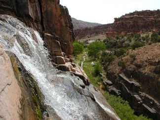
A waterfall flows down a rocky slope with red canyon walls and green vegetation visible in the background
Dominguez Creek waterfall cascading down rocky canyon walls

Dominguez Canyon Wilderness history and protected-area timeline

Dominguez Canyon Wilderness has a relatively short formal history as a designated protected area, but it sits within a landscape with deeper layers of land use and conservation significance. The underlying terrain, dominated by canyon systems draining the northeastern Uncompahgre Plateau, has long supported ranching, hunting, and dispersed recreation, while also being recognized for its scenic and ecological values.

The broader Dominguez-Escalante National Conservation Area, of which the wilderness is a part, was established before the wilderness designation itself, creating a larger landscape-scale framework for managing the region's resources. In 2009, the wilderness component was formally designated, bringing approximately 66,280 acres under the protections of the U.S. Wilderness Area system. With that designation, the area became the largest BLM roadless area in Colorado, elevating its standing within the National Wilderness Preservation System.

Since 2009, management of the wilderness has continued under the Bureau of Land Management, with an emphasis on preserving its roadless character, canyon ecosystems, and the contrast between mesa-top and canyon-bottom environments that define the area's identity.

Dominguez Canyon Wilderness landscape and geographic character

The landscape of Dominguez Canyon Wilderness is shaped by the geology of the Uncompahgre Plateau's northeastern margin, where erosion by creeks and runoff has sliced through sandstone layers to form two main canyon systems. The result is a terrain of high, relatively flat mesa tops dropping abruptly into deeply cut drainages, with sandstone cliffs, benches, talus, and exposed rock layering throughout.

The mesa and plateau uplands above the canyons are characterized by broad expanses of pinyon-juniper woodland and open sagebrush country typical of western Colorado's high desert. From these elevations, the land falls into drains that converge on Dominguez Creek and its tributaries, producing the waterfalls, plunge pools, and shaded rock walls that give the canyon country its distinctive appearance.

This combination of expansive tablelands and enclosed canyon corridors creates strong internal contrast within the wilderness. Hikers moving from rim to canyon floor encounter major shifts in slope, exposure, vegetation, and sound, with the lower canyons feeling sheltered and lush compared to the hot, dry, wind-swept uplands above.

Dominguez Canyon Wilderness ecosystems, habitats, and plant life

Dominguez Canyon Wilderness spans an ecological gradient that runs from arid plateau uplands down through canyon slopes and into narrow riparian corridors. The mesa tops support drought-adapted vegetation communities built around pinyon pine, Utah juniper, and a mosaic of sagebrush, grass, and scrub species typical of Colorado's high desert environments.

As elevation drops into the canyons and side drainages, microclimates change. Shaded sandstone walls and seeps support scattered Gamble's oak, serviceberry, and other mountain shrub species, while perennial and intermittent stream reaches along Dominguez Creek create ribbons of riparian vegetation including cottonwoods and willows. These canyon-bottom habitats stand out starkly against the dry uplands and are central to the area's ecological character.

Together, these varied environments support a mix of plant communities typical of the canyon country of the northern Uncompahgre Plateau, with desert uplands, mountain shrub draws, and riparian stringers all within a relatively compact wilderness footprint.

Dominguez Canyon Wilderness wildlife and species highlights

Wildlife in Dominguez Canyon Wilderness reflects the area's mix of dry plateau habitats and sheltered canyon environments. The upland pinyon-juniper and sagebrush landscapes support typical high-desert species, while the riparian corridors along Dominguez Creek and its tributaries provide important habitat for birds, small mammals, and other wildlife that depend on water and denser vegetation.

The canyon environments in particular concentrate wildlife activity around water sources, rock cover, and the structural complexity of cliff and talus terrain. These features make the canyons important for both resident species and seasonal visitors, contributing to the broader biological richness that helped justify the area's wilderness designation.

Dominguez Canyon Wilderness conservation status and protection priorities

Dominguez Canyon Wilderness carries strong conservation significance as the largest Bureau of Land Management roadless area in Colorado, protecting a substantial block of relatively unmodified canyon and plateau terrain within a region that otherwise faces considerable development pressure. Its designation in 2009 placed approximately 66,280 acres under the legal protections of the U.S. Wilderness Area system, restricting road construction, motorized use, and other forms of development.

Beyond its formal wilderness status, the area forms the core of the much larger Dominguez-Escalante National Conservation Area, giving it a broader conservation context that helps maintain ecological processes and habitat connectivity across the northeastern Uncompahgre Plateau. The combination of mesa-top, canyon slope, and riparian habitats within a single roadless unit enhances its conservation value, protecting ecological gradients that would otherwise be vulnerable to fragmentation from roads, energy development, and other land uses common on surrounding BLM lands.

Dominguez Canyon Wilderness cultural meaning and human context

The landscape of Dominguez Canyon Wilderness lies within a region of western Colorado with a long history of human use, including ranching, hunting, and dispersed recreation in canyon and plateau terrain. The surrounding country retains a strong ranching identity, and the canyon systems themselves carry layers of historical use tied to water, grazing, and travel through the Uncompahgre Plateau.

As part of the larger Dominguez-Escalante National Conservation Area, the wilderness sits within a landscape that connects contemporary conservation with the longer human story of the Uncompahgre Plateau region, where canyon corridors have long served as both travel routes and focal points for local livelihoods in an otherwise arid environment.

Top sights and standout views in Dominguez Canyon Wilderness

The defining highlights of Dominguez Canyon Wilderness are its two major canyon systems draining the northeastern Uncompahgre Plateau, with Dominguez Creek and its tributary canyons offering waterfall scenery, pools, and sheltered riparian corridors that contrast sharply with the open mesa tops above. The wilderness's status as Colorado's largest BLM roadless area gives it particular weight within the National Wilderness Preservation System, while its position within the larger Dominguez-Escalante National Conservation Area ties it to a broader landscape-scale conservation framework.

Its accessibility from Grand Junction combined with the sense of deep remoteness once inside the canyons makes the area distinctive, offering wilderness character within relatively short travel distances from a regional population center.

Best time to visit Dominguez Canyon Wilderness

The character of Dominguez Canyon Wilderness shifts meaningfully with the seasons, with spring and fall typically offering the most comfortable conditions for exploring both the upland mesas and the canyon corridors. Cooler temperatures in these shoulder seasons make long approaches and descents into the canyons more manageable, while spring runoff can enhance waterfalls and stream flow along Dominguez Creek.

Summer brings intense heat on the exposed mesa tops and canyon benches, though shaded canyon reaches remain cooler and continue to offer water and vegetation. Winter can transform the area into a quieter, snow-dusted high-desert landscape, with canyon pools sometimes icing over and the open plateaus seeing limited visitation. Across all seasons, canyon-bottom conditions tend to be more sheltered and water-influenced than the windswept uplands above.
Monthly climate preview

Long-term representative temperature and precipitation patterns across the elevation profile

Dominguez Canyon Wilderness Climate Normals and Annual Weather by Month

Representative coordinate records show measured monthly temperature ranges and steady precipitation averages across the protected terrain. Reviewing the complete twelve-month climatology dataset reveals broader meteorological patterns and detailed temperature variations for Dominguez Canyon Wilderness.
Annual mean7 °C
-5 °C22 °C
Jan-5°
Feb-3°
Mar
Apr
May11°
Jun18°
Jul22°
Aug20°
Sep15°
Oct
Nov
Dec-4°
Warmest month
July

21.6 °C

Coolest month
January

-4.8 °C

Wettest month
September

1.4 mm/day

Driest month
June

0.6 mm/day

Park location guide

Geography guide, regional context, and park location map for Dominguez Canyon Wilderness

Dominguez Canyon Wilderness park geography, regions, and map view in United States of America

Understand where Dominguez Canyon Wilderness sits in United States of America through a broader geographic reading of the surrounding landscape, nearby location context, and its mapped position within the national park landscape.

How Dominguez Canyon Wilderness fits into United States of America

The United States of America is a federal presidential republic and one of the world's largest countries by area and population. It consists of 50 states across a vast territory spanning multiple time zones, with its capital in Washington, D.C. and largest city in New York City. The nation has a diverse economy, influential political system, and significant cultural and military presence globally.

Wider geography shaping Dominguez Canyon Wilderness in United States of America

The United States occupies a vast territory in North America, bordered by Canada to the north and Mexico to the south. The 48 contiguous states stretch from the Atlantic to the Pacific Ocean, while Alaska occupies the northwestern region and Hawaii is an archipelago in the Pacific. The country encompasses diverse terrain including the Rocky Mountains, Appalachian Mountains, Great Plains, and extensive river systems.

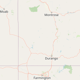
Map view of Dominguez Canyon Wilderness

Use this park location map to pinpoint Dominguez Canyon Wilderness in United States of America, understand its exact geographic position, and read its mapped placement within the surrounding landscape more clearly.

Pigeon | © OpenStreetMap contributors

Location context for Dominguez Canyon Wilderness

Colorado
Recorded earthquake history

View the Dominguez Canyon Wilderness Recorded Earthquake History Catalogue

Review the historical collection of seismic events recorded in the vicinity of Dominguez Canyon Wilderness. MoriAtlas provides a clear, structured overview of USGS data, allowing for meaningful exploration of the recorded seismic past of this Colorado wilderness area and its surrounding plateau terrain.

Dominguez Canyon Wilderness Earthquake History

Catalogued events

3 events

Strongest magnitude

Magnitude 3.7

Most recent event

Apr 3, 2025

This history includes earthquakes recorded inside the park or within 50 km of its borders

Visualizing sandstone canyons, mesas, and protected habitats of western Colorado

Dominguez Canyon Wilderness Photos and Landscape Scenery

Visual records illustrate the dramatic geological transition between high desert tablelands and deep, water-carved canyon corridors across Dominguez Canyon Wilderness. Examining these protected landscapes reveals the rugged terrain, riparian vegetation, and striking topography defining the Uncompahgre Plateau region.

A waterfall flows down a rocky slope with red canyon walls and green vegetation visible in the background

Park atlas

Compare regional canyons, plateau terrain, and adjacent public lands

Parks Near Dominguez Canyon Wilderness and Surrounding Protected Landscapes

Browsing other parks near Dominguez Canyon Wilderness reveals a wide network of western Colorado public lands and protected plateau terrain. Comparing these adjacent conservation areas provides deeper context on regional high desert ecosystems and sandstone canyon geology.
Protected landscapeColorado
10 km away#1 closest

Northeast

Grand Mesa National Forest: A Comprehensive Atlas of Colorado High-Plateau Geography

Mapping the basalt-capped flat-top mountain terrain

Grand Mesa National Forest stands as a primary protected landscape within the Colorado Rockies, characterized by its signature basalt-capped plateau. This forest unit serves as a vital geographic landmark, offering unique insights into high-altitude mountain terrain, subalpine water systems, and historical forest conservation. Learn about the boundaries and physical landscape features that define this massive elevated tableland above the surrounding dry valleys.

Area
1,402.46 km²
Established
1892
Relief
Highland
Climate
Alpine
National parkMontrose County
39 km away#2 closest

East

Black Canyon of the Gunnison National Park: Protected Area Geography and Mapped Landscape

Explore the natural terrain and protected boundaries in Montrose County.

Black Canyon of the Gunnison National Park is a national park defined by its profound geological features and its status as a protected landscape. Located within Montrose County, it offers a distinct geographic profile for atlas-based exploration. Users can understand the park's mapped boundaries, its relation to the surrounding regional geography, and the unique natural terrain that defines this protected area, contributing to a structured discovery of its natural landscape identity.

Area
124.4 km²
Established
1999
IUCN
II
Visitors
357.1K annual
Protected landscapeUtah
44 km away#3 closest

West

Manti, La Sal National Forest: Geographic Overview of Utah's Mountain and Canyon Landscapes

Mapped protected forest boundaries across the Colorado Plateau

Spanning over one million acres, Manti, La Sal National Forest defines a critical segment of Utah geography. This protected landscape encompasses diverse terrain including subalpine mountains, aspen-rich uplands, and deep canyon networks. Use this atlas to examine the distinct environmental characteristics that separate the northern forested plateaus from the southern wilderness canyons.

Area
5,143.09 km²
Established
1950
IUCN
V
Visitors
900K annual
Protected areaColorado
77 km away#4 closest

Southeast

Mount Sneffels Wilderness: Mapping the High Alpine Terrain of the San Juan Mountains

Protected mountain geography in southwestern Colorado

Mount Sneffels Wilderness protects a dramatic cluster of peaks in the San Juan range, characterized by glacial cirques, expansive talus fields, and sharp ridgelines. As a vital component of the Colorado backcountry, this area provides a window into high-altitude ecological transition zones, from dense conifer forests to exposed granite summits that define the character of the Uncompahgre National Forest.

Area
67.04 km²
Established
1980
IUCN
Ib
Relief
Mountain
National parkUtah
80 km away#5 closest

West

Arches National Park: Utah National Park Protected Landscape Exploration

Explore mapped terrain and geographic context.

Delve into the specifics of Arches National Park, a protected national park located in Utah. This atlas-focused entry provides detailed insight into the park's protected landscape features and geographic distribution. Understand the mapped park boundaries and the unique natural terrain that shapes this significant conservation area within the United States' broader regional geography.

Area
310.31 km²
Established
1971
IUCN
II
Visitors
1.5M annual
Protected landscapeColorado
86 km away#6 closest

Southeast

San Juan National Forest: Geographic Overview of a Major Southern Colorado Protected Landscape

Mapped terrain across the Southern San Juan Mountains

San Juan National Forest represents a massive protected landscape in western Colorado, defined by its rugged alpine peaks, dense conifer forests, and glacial valleys. This atlas entry details the forest boundary, its position along the Continental Divide, and the surrounding transition into the Colorado Plateau. It provides a structured look at the terrain that connects diverse ecosystems, from high-altitude tundra to expansive mesa country, within one of the largest national forests in the American West.

Area
7,603.42 km²
Established
1905
Relief
Mountain
Climate
Alpine
Protected areaColorado
About 87 km away#7 closest

East

Curecanti National Recreation Area: Mapped Geography and Protected Landscapes of Western Colorado

River-based recreation and volcanic canyon terrain

Curecanti National Recreation Area stretches across Gunnison and Montrose counties, serving as a primary water-based protected landscape in Colorado. The area preserves the geologic transitions from the broad expanse of Blue Mesa Reservoir to the granite-walled canyons of Morrow Point and Crystal, offering a deep look into the regional geography and historical infrastructure of the Gunnison basin.

Area
174.4 km²
Established
1965
Visitors
807.1K annual
Relief
Mountain
Wildlife reserveColorado
88 km away#8 closest

South

Lizard Head Wilderness: Mapping the San Juan Mountains Protected Alpine Terrain

High elevation geography and volcanic wilderness in Colorado

Lizard Head Wilderness is a federally protected area in southwestern Colorado characterized by steep ridgelines, dramatic volcanic geology, and alpine basins. It protects a rugged mountain landscape featuring the iconic Lizard Head spire and a cluster of high-elevation peaks including Mount Wilson, El Diente Peak, and Wilson Peak. The area offers a significant study in remote high-mountain geography and watershed protection within the San Juan range.

Area
167.17 km²
Established
1980
IUCN
Ib
Relief
Mountain

Common questions about visiting, size, designation, and location context for Dominguez Canyon Wilderness

Dominguez Canyon Wilderness FAQs for park facts, access, geography, and protected area context

Find quick answers about Dominguez Canyon Wilderness, including protected-area facts, park geography, trail and visitor context, and how the park fits into its surrounding country and regional landscape.
MoriAtlas Explorer

Continue Your Protected Areas Search Across the Global Atlas

Deepen your exploration by continuing the structured search for national parks and protected areas worldwide. Utilize the comprehensive filtering capabilities to compare different conservation landscapes and refine your understanding of global park geography. Discover more about the distribution and characteristics of protected natural areas.

Global natural geography