
Mori Atlas logo
Nature reserveDortebachtal

Tracing the protected geographic boundaries and rugged landscape features of a historic Mosel side valley.

Dortebachtal Nature Reserve and Alpine-Like Erosion Valley in Rhineland-Palatinate, Germany

(Naturschutzgebiet Dortebachtal)

Dortebachtal stands as a significant protected nature reserve along the Mosel River, characterized by its deep, narrow erosion valley and alpine-like rock formations. This site showcases a complex terrain where steep, dry cliffs contrast with a cool, shaded stream course that includes a natural waterfall. By mapping its unique geography and long-standing protection status, the area serves as an essential example of sensitive riparian habitats and rocky ravine environments within the broader landscape of Rhineland-Palatinate.

Naturschutzgebietnature reserveMosel valleyside valleyerosion valleywaterfall
A vibrant, flat-style digital illustration of a valley featuring a cascading waterfall, rocky cliffs covered in moss, evergreen trees, and a sunset-lit sky.

Dortebachtal

Nature reserve

Park overview

Structured park overview, official facts, and landscape profile for Dortebachtal

Dortebachtal park facts, protected area profile, and essential visitor context

Review the core facts for Dortebachtal, including designation, size, terrain, visitor scale, habitats, and operating context in one park-focused overview.

About Dortebachtal

Dortebachtal is a compact nature reserve in the Middle Mosel region of Rhineland-Palatinate, occupying a small but visually dramatic side valley of the Mosel River near the village of Klotten. Although the protected area covers only a limited geographic footprint, it preserves a particularly expressive piece of the Mosel valley's natural landscape: a deeply incised, erosion-shaped ravine formed by the Dortebach, where steep slate rock faces, a winding stream course, and a sheltered gorge combine into a setting that feels surprisingly alpine for this part of the Rhine-Mosel region.

The reserve's defining character comes from its geology and hydrology. The Dortebach, a modest northern tributary of the Mosel, has over time cut a sharp lower valley that opens southward between two prominent rock headlands. Just above this opening, a rocky ridge juts in from the west, forcing the stream to bend around it at almost a right angle. From the Mosel itself up to this protruding spur, the western flank of the valley is a wall of steep, dry rock, while the eastern flank slopes more gently. This asymmetric profile gives the valley a clear sense of enclosure and depth, especially where the rock walls close in around the stream.

In addition to its scenic value, the reserve protects habitat along a spring-fed stream with associated moist woodland and cliff vegetation, as well as the rocky outcrops that line the slopes. A waterfall along the Dortebach adds to the mosaic of microhabitats, and the cool, shaded conditions near the stream support moisture-loving species such as mayfly larvae, which are documented in the reserve's stream fauna. These conditions contrast with the hot, dry rock faces on the western side, creating a small but ecologically varied protected landscape within an otherwise intensively cultivated wine-growing region.

The nature reserve has been formally protected since 20 May 1930, making it one of the older designated nature areas in the Cochem-Zell district. Its proximity to the B 49 federal road is a notable feature of its accessibility: visitors approaching on foot follow a hand-carved wooden sign that leads them beneath the railway line directly into the valley, offering an unusually direct transition from the busy infrastructure corridor of the Mosel into the quiet protected gorge. The valley is also incorporated into the Moselsteig, the long-distance hiking trail that traces the Mosel, which has helped establish Dortebachtal as a recognized short hike and scenic highlight within the broader regional trail network.

Quick facts and research context for Dortebachtal

Dortebachtal is a designated nature reserve (Naturschutzgebiet) in Rhineland-Palatinate, Germany, located in the municipality of Klotten within the Cochem-Zell district. It was placed under protection on 20 May 1930 by decree of the Bezirksregierung Koblenz, making it one of the older formal nature reserves in the region. The reserve follows the Dortebach, a northern tributary of the Mosel, and extends from the river valley upward into a narrow erosion valley.

A distinctive feature is the alpine-like lower portion of the valley, where steep dry rock faces rise on the western side and the stream loops around a rocky spur. The reserve lies adjacent to the B 49 federal road, from which a carved sign directs visitors under the railway line into the valley. Dortebachtal is also part of the Moselsteig hiking trail, which runs along the Mosel.

The protected area is listed among the nature reserves of the Cochem-Zell district alongside other sites such as Brauselay, Ediger Laach, Falkenlay, Pommerheld, and Ulmener Maar.

Protection and recognition

Explore terrestrial protection records and official designation context for Dortebachtal.

Dortebachtal Protection Status and Documented Conservation Scope

Dortebachtal maintains a recorded terrestrial protection scope within its designated conservation framework. Documented protection status details and management parameters provide essential context for understanding the protected area landscape.

Protection details

Protection scope
Terrestrial
Park context

Deeper park guide and search-rich context for Dortebachtal

Dortebachtal history, landscape, wildlife, and travel context

Explore Dortebachtal through its history, landscape character, ecosystems, wildlife, conservation priorities, cultural context, and seasonal travel timing in a structured park guide built for atlas discovery and search intent.

Why Dortebachtal stands out

Dortebachtal is best known for its dramatically narrow, alpine-feeling erosion valley right beside the Mosel: a short, steep side valley where the small Dortebach cuts between two rocky headlands and bends at a right angle around a protruding ridge. The contrast between the sheer, dry western rock walls and the more gentle eastern slope gives the valley a striking scenic profile that feels far more rugged than its modest size would suggest. The reserve is also recognized for its waterfall along the Dortebach, its long-standing protection status dating back to 1930, and its inclusion in the Moselsteig trail network, which has made it a popular short detour for hikers exploring the Mosel valley.
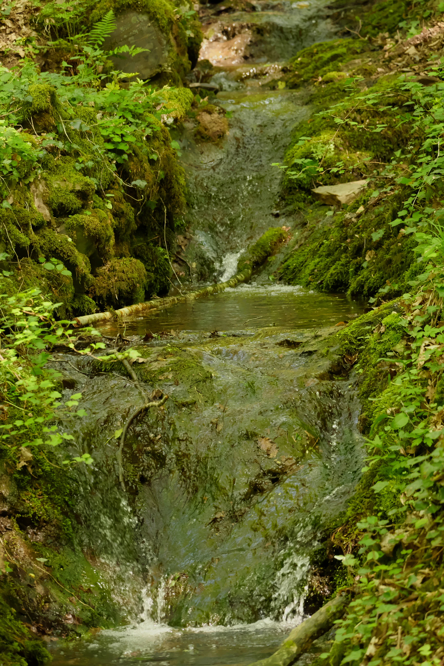
A small cascading waterfall flows down over dark moss-covered rocks in a lush, green forest setting.
The Dortebach stream flows over mossy rock formations in the Dortebachtal nature reserve.

Dortebachtal history and protected-area timeline

Dortebachtal has been under formal nature protection since 20 May 1930, when it was designated as a Naturschutzgebiet by decree of the Bezirksregierung Koblenz, the regional administrative authority in Koblenz. This early designation places it among the older formal nature reserves in the Cochem-Zell district of Rhineland-Palatinate and reflects an era in which many of Germany's most distinctive small-scale landscapes were first placed under legal protection.

The valley's protected status has been maintained continuously since that original 1930 ordinance, preserving the rock formations, the stream corridor, and the habitats along the Dortebach. In more recent decades, the valley has also gained a renewed profile through its incorporation into the Moselsteig, the long-distance trail that follows the Mosel River, which has helped introduce the small reserve to a broader audience of hikers and visitors to the Mosel wine region.

Dortebachtal landscape and geographic character

The landscape of Dortebachtal is defined by a short, deeply incised erosion valley cut into the slopes of the Middle Mosel. The lower part of the valley has an almost alpine profile, opening to the south toward the Mosel between two rocky headlands. Slightly above this mouth, a rugged ridge projects from the western side, forcing the stream to swing around it at a close to right angle.

From the level of the Mosel up to this protruding spur, the western flank of the valley is dominated by steep, dry rock faces with little soil cover, while the eastern slope is gentler and more graded. The rocky walls create strong contrast with the cool, shaded stream course below, which runs over stones and boulders and includes a notable waterfall. The combination of warm-exposed cliffs on one side and a damp, sheltered streambed on the other gives the small valley a striking visual diversity despite its limited size.

The valley sits within the broader setting of the Mosel valley, a region known for its steep vineyard slopes, but Dortebachtal itself remains a natural, forested ravine that contrasts with the surrounding cultivated hillsides. The reserve is traversed by the Moselsteig trail, which links the valley into the wider scenic route along the Mosel.
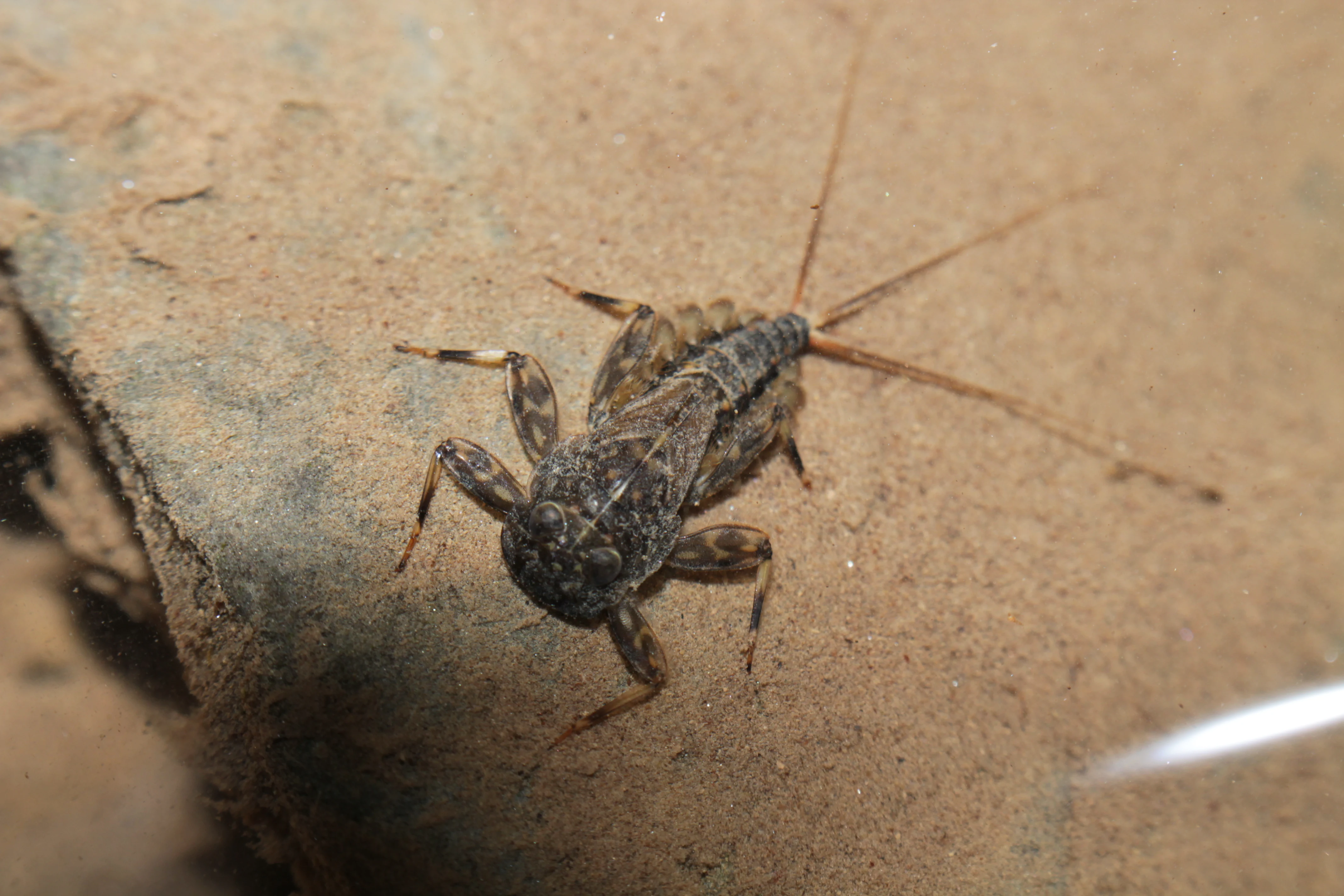
A close up view of a mayfly larva resting on a submerged stone underwater.
A mayfly larva observed in the Dortebachtal Nature Reserve, highlighting the local aquatic biodiversity.

Dortebachtal ecosystems, habitats, and plant life

Dortebachtal protects a small but ecologically varied section of the Mosel valley, centered on the Dortebach and the steep slopes on either side. The habitats of the reserve are shaped largely by the contrast between the dry, sun-exposed rock faces of the western side and the cooler, moister conditions along the stream and on parts of the eastern slope. This juxtaposition within a very compact area allows several different microhabitats to coexist in close proximity.

The stream itself supports a moist, shaded environment with mossy rocks, damp woodland alongside the streambed, and cool microclimates near the waterfall. These conditions are favorable for moisture-loving invertebrates such as mayfly larvae, which have been recorded in the Dortebach, and for the overall health of the small watercourse. Along the steeper sunny cliffs of the western flank, vegetation is sparser and adapted to dry, rocky conditions, while the gentler eastern slope supports a more continuous cover of mixed woodland typical of the Middle Mosel.

Within the wider context of the heavily cultivated Mosel landscape, dominated by vineyards and settlements, the valley functions as a small refuge of more natural, structurally diverse habitat. Its protection preserves both the rock formations and the ecological continuity of the Dortebach corridor from the surrounding land uses.
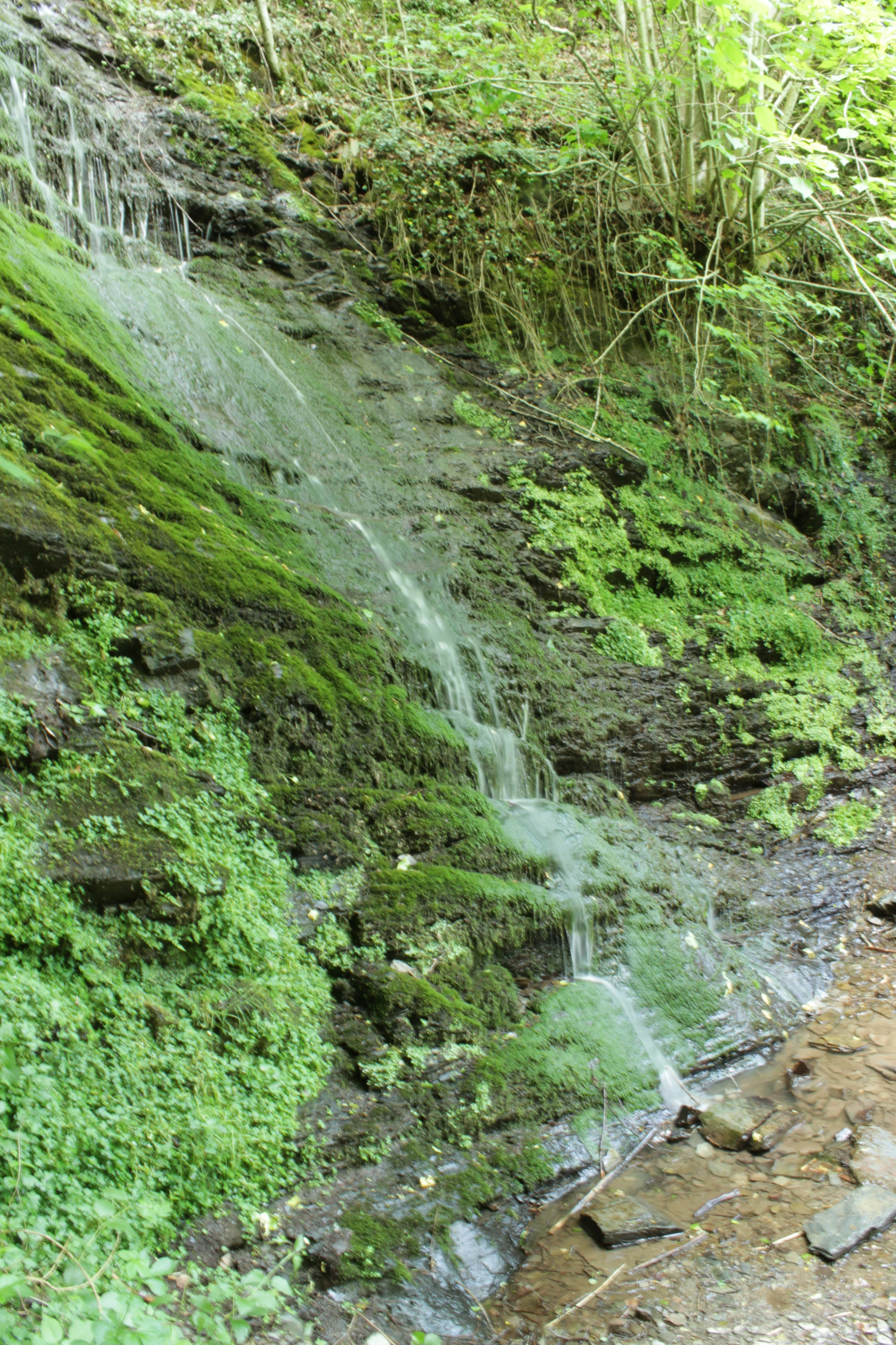
A small, thin waterfall trickles over a dark, layered rock cliff covered in bright green moss and lush vegetation.
A delicate waterfall cascading down a mossy rock face in the Dortebachtal valley.

Dortebachtal wildlife and species highlights

Wildlife in Dortebachtal is closely tied to the valley's mosaic of dry rocky slopes, shaded stream, and mixed woodland. The cool, shaded sections along the Dortebach support moisture-dependent invertebrates, and mayfly larvae in particular are documented as part of the stream's fauna, indicating the good water quality and habitat conditions of the small watercourse.

The combination of dry cliff habitat on the western flank, more sheltered woodland on the eastern slope, and the damp riparian zone along the stream creates favorable conditions for a range of birds, insects, and small forest-dwelling species typical of the Middle Mosel region. While the reserve is not primarily known for large mammals, its structural diversity gives it value as a refuge within a heavily cultivated wine-growing landscape, where similar natural habitat is otherwise scarce.

Dortebachtal conservation status and protection priorities

Dortebachtal's primary conservation significance lies in preserving a distinctive, structurally rich piece of the Mosel valley that would otherwise be vulnerable to the pressures of surrounding land use, particularly viticulture and settlement development. By protecting the steep rock faces, the Dortebach stream corridor, and the associated woodland, the reserve maintains a small but ecologically valuable refuge of more natural habitat within an intensively used cultural landscape.

Its early designation as a Naturschutzgebiet in 1930 reflects the long-standing recognition of the valley's natural value, and its continuous protection since then has allowed the rock formations, stream habitats, and associated vegetation to remain largely intact. The valley's inclusion in the Moselsteig trail network also plays a role in conservation awareness, drawing attention to a small but high-quality protected landscape and reinforcing its identity as a recognized natural highlight within the Mosel region.

Dortebachtal cultural meaning and human context

Dortebachtal sits within the broader cultural landscape of the Middle Mosel, a region with a centuries-long tradition of wine-making along steep riverside slopes. The small reserve represents a rare stretch of natural, non-cultivated valley within this otherwise intensively shaped cultural landscape, offering a contrast that is central to the valley's local identity.

A hand-carved wooden sign along the B 49 directs visitors under the railway line and into the valley, an expression of local engagement with the protected area as a place for walking and quiet enjoyment. The valley's integration into the Moselsteig hiking trail further embeds it in the regional culture of hiking and outdoor recreation that has grown along the Mosel in recent decades.

Top sights and standout views in Dortebachtal

The Dortebachtal reserve's most distinctive highlights are concentrated in its lower valley: the alpine-like erosion gorge, the steep dry rock walls on the western side, the right-angle bend of the Dortebach around the protruding rocky ridge, and the waterfall along the stream. Together these features give the small valley an unusually dramatic character for its size.

Equally notable is the valley's long protection history, dating back to 1930, and its role as a section of the Moselsteig trail. The simple but effective access point, with its carved wooden sign leading visitors from the B 49 under the railway into the reserve, makes Dortebachtal a particularly inviting example of how a modest nature reserve can offer a high-quality scenic experience right beside one of Germany's most famous river valleys.

Best time to visit Dortebachtal

Dortebachtal can be visited throughout much of the year, but its character changes noticeably with the seasons. Spring and early summer bring fresh green foliage, active stream flow, and strong visibility of the waterfall, making this an especially attractive period for hiking and for observing the moist woodland habitat along the Dortebach.

Late summer and early autumn draw visitors into the Mosel region more broadly for wine-related tourism and walking along the Moselsteig, with the valley offering a cool, shaded contrast to the warmer vineyards around it. Winter visits are possible but bring shorter daylight hours and colder conditions along the damp streambed, which can make the rocky sections of the trail more slippery. The shoulder seasons often provide a quieter experience and good conditions for appreciating the rock formations and the contrast between the dry western cliffs and the sheltered eastern slope.


Monthly climate preview

Long-term representative point measurements for annual weather by month

Dortebachtal Climate Normals and Measured Annual Temperature Patterns

Dortebachtal records measured monthly temperature ranges and precipitation averages from NASA POWER climatology datasets spanning 1991 through 2020. Reviewing the complete twelve-month profile reveals detailed monthly fluctuations in local temperature and precipitation.
Annual mean9 °C
0 °C19 °C
Jan
Feb
Mar
Apr
May13°
Jun16°
Jul19°
Aug19°
Sep14°
Oct
Nov
Dec
Warmest month
July

18.9 °C

Coolest month
January

-0.1 °C

Wettest month
December

2.3 mm/day

Driest month
April

1.5 mm/day

Park location guide

Geography guide, regional context, and park location map for Dortebachtal

Dortebachtal park geography, regions, and map view in Germany

Understand where Dortebachtal sits in Germany through a broader geographic reading of the surrounding landscape, nearby location context, and its mapped position within the national park landscape.

How Dortebachtal fits into Germany

Germany is a federal republic in Western and Central Europe with a population of over 83 million across sixteen constituent states. It is Europe's largest economy by nominal GDP and a major global exporter and importer. The capital is Berlin, and the country borders Denmark, Poland, Czech Republic, Austria, Switzerland, France, Luxembourg, Belgium, and the Netherlands.

Wider geography shaping Dortebachtal in Germany

Germany is located in Western and Central Europe, spanning 357,022 km². It borders Denmark to the north, Poland and the Czech Republic to the east, Austria and Switzerland to the south, and France, Luxembourg, Belgium, and the Netherlands to the west. The country has coastlines on the Baltic Sea and North Sea to the north, with the Alps located in the southern region.

Map view of Dortebachtal

Use this park location map to pinpoint Dortebachtal in Germany, understand its exact geographic position, and read its mapped placement within the surrounding landscape more clearly.

Pigeon | © OpenStreetMap contributors

Location context for Dortebachtal

Rhineland-Palatinate

Explore visual records of steep rock faces, riparian habitats, and alpine erosion profiles within the nature reserve.

Dortebachtal Photos and Landscape Scenery: Visualizing the Protected Mosel Valley Gorge

Visual documentation reveals the dramatic terrain of Dortebachtal, highlighting sheer western rock walls, shaded stream courses, and rare waterfall formations. Studying these protected area photographs provides clear insight into the distinct ecological character and rugged topography of the Mosel river ravine.

A small cascading waterfall flows down over dark moss-covered rocks in a lush, green forest setting.

A close-up view of a white trail marker sign labeled Moselsteig attached to a wooden railing, with a blurred stream and green foliage in the background.

A close up view of a mayfly larva resting on a submerged stone underwater.

A small, thin waterfall trickles over a dark, layered rock cliff covered in bright green moss and lush vegetation.

Park atlas

Discover related nature reserves and regional valley landscapes for deeper geographic comparison.

Explore Protected Areas and Parks Near Dortebachtal in the Mosel Region

Compare Dortebachtal with other protected areas and nature reserves located throughout the surrounding Mosel river valley. Examining adjacent natural terrain and regional park geography provides broader context for conservation landscapes in Rhineland-Palatinate.
Watercolor painting of a green landscape with a winding river, forest patches, and soft hills in the background.
Nature reserveRheinland-Pfalz
About 3.9 km away#1 closest

Southwest

Brauselay Nature Reserve: Mapping the Quartzite Cliffs of the Mosel Valley, Rheinland-Pfalz

A protected landscape featuring steep rock faces and dry grassland ecosystems.

Brauselay stands as a prominent protected nature reserve in the Mosel valley, characterized by a striking 65-meter quartzite cliff. The site supports a specialized Mediterranean-style flora and rare wildlife species adapted to its sun-warmed, heat-retaining slate and sandstone terrain. Its proximity to the Mosel River and integration with regional trail networks make it a landmark for studying the intersection of river valley geography and protected ecological habitats.

Area
0.133 km²
Established
1941
Nature reserveRhineland-Palatinate
About 15 km away#2 closest

Northeast

Nettetal Nature Reserve: Geography and Protected Boundaries in Rhineland-Palatinate

Steep-sided valley landscapes and biodiversity corridors.

Nettetal Nature Reserve offers a deep look into the geomorphology of a classic Kerbtal in Rhineland-Palatinate. This protected area along the Nette tributary showcases a rare density of contrasting terrains, from sun-exposed rock formations to damp valley floors, providing a clear window into regional conservation mapping.

Area
7.05 km²
Established
1986
Scope
Terrestrial
Water
Major water bodies
Protected areaRheinland-Pfalz
About 17 km away#3 closest

West

Ulmener Maar Protected Area: Mapping Crater Lakes and Eifel Volcanic History

Volcanic maar, medieval ruins, and meromictic lake geography

Ulmener Maar provides a rare glimpse into the volcanic evolution of the Eifel region. This protected area centers on a deep, meromictic crater lake cradled by a forested tuff ring, connected via historical tunnels to the older Jungferweiher maar. It serves as a vital point for understanding the interplay between geological youth and centuries of human settlement in Germany.

A watercolor painting showing a rocky, layered cliff face in the center, surrounded by green foliage, with rolling hills and a mountain range in the background against a white backdrop.
Protected areaRheinland-Pfalz
About 18 km away#4 closest

North

Mayener Grubenfeld: Protected Industrial Landscapes and Volcanic Terrain in Germany

A historic basalt mining district and vital bat hibernation hub

The Mayener Grubenfeld preserves deep traces of volcanic activity and industrial evolution, marked by porous basalt sheets and centuries of extraction. Today, the terrain consists of abandoned quarry pits, gallery systems, and dry grassland habitats that form a protected area of significant geological and ecological value within Rheinland-Pfalz.

Area
1.5 km²
Relief
Upland
Climate
Temperate
Access
Easy access
Nature reserveRhineland-Palatinate
About 19 km away#5 closest

Northeast

Ausoniusstein Nature Reserve: Protected Landscape and Geographic Identity in Germany

A geological and ecological refuge in the Rhineland-Palatinate countryside.

Ausoniusstein is a protected nature reserve in western Germany recognized for its unique geological and morphological character. Spanning 31 hectares, the site features rocky slopes and varied volcanic substrates that support uncommon plant life and the rare Apollo butterfly. The terrain represents the transitional landscape between the Moselle river corridor and the Eifel foothills.

Area
0.31 km²
Established
1984
Relief
Upland
Water
Minor water
A horizontal watercolor painting showing a soft, stylized landscape of green rolling hills and volcanic peaks behind a line of pine trees and a calm body of water in the foreground.
Nature reserveRheinland-Pfalz
About 21 km away#6 closest

North

Hochsimmer Nature Reserve: Volcanic Topography and Forested Highlands of the Eastern Eifel

A study of basaltic twin cones and protected regional wilderness

Hochsimmer is a well-defined volcanic cinder cone near the Mayen-Koblenz district, characterized by its twin-peak profile and expansive woodland canopy. This protected nature reserve anchors the local topography where the volcanic Eifel meets the Middle Rhine basin, offering an essential reference for understanding the geological and ecological structure of the Rhineland-Palatinate high country.

Area
2.491 km²
Established
1973
Relief
Mountain
Climate
Temperate
A soft watercolor painting of a green, rolling hillside with trees, set against a pale, light-filled background.
Nature reserveRhineland-Palatinate
About 22 km away#7 closest

North

Hochstein Nature Reserve: Geological Mapping and Protected Eifel Landscape Context

An extinct volcanic cone protected within Rhineland-Palatinate

Hochstein stands as a representative Vulkanberg in the Osteifel, offering a clear visual landmark of Germany's volcanic history. This protected nature reserve encompasses forested slopes, the storied Genoveva Cave, and the surrounding drainage basins of the Nette river system, providing a deep look into the regional geology and conservation boundaries of the Middle Rhine highland.

Area
3.511 km²
Established
1983
Relief
Mountain
Scope
Terrestrial
A soft, painterly watercolor illustration depicting a calm lake framed by evergreen trees and rolling green hills.
Nature reserveRhineland-Palatinate
About 24 km away#8 closest

West

Holzmaar Nature Reserve: Volcanic Crater Geography and Sediment Archive in Germany

A forest-enclosed maar lake in the Vulkaneifel region.

Holzmaar represents a significant volcanic maar site within Rhineland-Palatinate, defined by its circular basin, wetland-rich margins, and stream-fed hydrology. Recognized as a critical reference for paleoclimate research, its laminated sediment layers provide a detailed look at late-glacial European environmental history.

Area
0.068 km²
Relief
Upland
Climate
Temperate
Scope
Terrestrial

Common questions about visiting, size, designation, and location context for Dortebachtal

Dortebachtal FAQs for park facts, access, geography, and protected area context

Find quick answers about Dortebachtal, including protected-area facts, park geography, trail and visitor context, and how the park fits into its surrounding country and regional landscape.
MoriAtlas Explorer

Continue Your Protected Areas Search Across the Global Atlas

Deepen your exploration by continuing the structured search for national parks and protected areas worldwide. Utilize the comprehensive filtering capabilities to compare different conservation landscapes and refine your understanding of global park geography. Discover more about the distribution and characteristics of protected natural areas.

Global natural geography