
Mori Atlas logo
Nature reserveDreifelder Weiher

Understanding the historic fishpond geography and wetland ecology in Rhineland-Palatinate

Dreifelder Weiher Nature Reserve and the Westerwälder Seenplatte Protected Landscape

Dreifelder Weiher represents the largest and most ecologically vital pond within the Westerwälder Seenplatte of Rhineland-Palatinate, Germany. This nature reserve, managed by the NABU Foundation, offers a unique window into the intersection of seventeenth-century fish farming history and modern European wetland conservation. The basin at 410 metres elevation supports rare dwarf rush swards and extensive reedbelts, grounding the regional geography in a legacy of scientific exploration and environmental stewardship.

pondwetlandfishpondnature reserveFauna-Flora-Habitat sitereedbeds
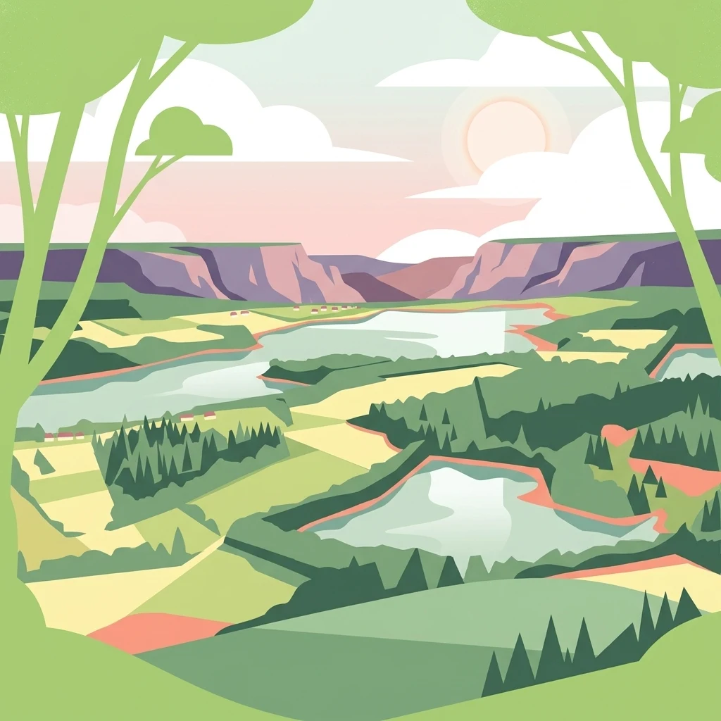
A flat-design, vector-style illustration of a rural landscape with multiple bodies of water, rolling green hills, forests, and distant bluffs under a soft-toned sky.

Dreifelder Weiher

Nature reserve

Park overview

Structured park overview, official facts, and landscape profile for Dreifelder Weiher

Dreifelder Weiher park facts, protected area profile, and essential visitor context

Review the core facts for Dreifelder Weiher, including designation, size, terrain, visitor scale, habitats, and operating context in one park-focused overview.

About Dreifelder Weiher

Dreifelder Weiher is a shallow, artificially created pond in the northern Westerwald, a low mountain range within the state of Rhineland-Palatinate in western Germany. With a surface area of about 123 hectares, it is the largest of several historic pond basins that collectively form the Westerwälder Seenplatte, an interconnected chain of stillwaters set in the rolling, forested plateau landscape west of the Wied valley.

The lake was created in the aftermath of the Thirty Years' War by Count Friedrich III of Wied, who established a series of ponds in partly marshy ground to support fish farming while expanding the existing hunting lodge of Haus Seeburg into a small noble estate. The surrounding Westerwald region had long served as a favoured hunting ground for the Wied dynasty and was also the early outdoor laboratory of Prince Maximilian zu Wied, whose careful natural history observations in the Westerwald preceded his later, widely published scientific expeditions to the Americas in the early nineteenth century.

Geographically, the pond lies near the headwaters of several streams that flow into the Rhine, most notably the Wied, which enters the lake on its eastern shore and exits through a controlled outlet structure on the northern bank. The basin sits at roughly 410 metres above sea level and stretches about two kilometres in length, with a maximum width of just under one kilometre. A small hamlet, Seeburg, lies on the western shore, while the village of Dreifelden borders the eastern side, giving the lake its present name.

In ecological terms, Dreifelder Weiher exemplifies the conservation value of traditionally managed fish ponds. Its extensive reedbelts, transition zones between open water and shoreline, and periodically exposed muddy bottom support rare species and are key reasons why the waters of the Westerwälder Seenplatte were designated a European Fauna-Flora-Habitat site. Since 2019, the pond and its neighbours have been owned by the NABU Foundation National Natural Heritage, securing their long-term protection as a coherent natural heritage complex within the Westerwaldkreis.

Quick facts and research context for Dreifelder Weiher

Dreifelder Weiher is a shallow artificial pond occupying roughly 123 hectares within the Westerwaldkreis of northern Rhineland-Palatinate, Germany. It lies at about 410 metres above sea level near the headwaters of the Wied river, which flows through the lake before continuing northwestward. The pond belongs to the Westerwälder Seenplatte, the largest stillwater in that group, and shares its name with the neighbouring village of Dreifelden.

Most of the shoreline and surrounding zones are designated as nature protection areas, and the Westerwalder Seenplatte waters are included in the European Fauna-Flora-Habitat network. Since 2019, the lake has been owned by the NABU-Stiftung Nationales Naturerbe, an environmental foundation focused on long-term protection and ecological management.

Protection and recognition

Documented terrestrial protection scope and conservation designation records

Dreifelder Weiher Protection Status and International Recognition Data

Dreifelder Weiher maintains a documented terrestrial protection scope within official conservation frameworks. Verified administrative records outline the governance history and international designation status associated with the protected landscape.

Protection details

Protection scope
Terrestrial
Transboundary protection
No
Park context

Deeper park guide and search-rich context for Dreifelder Weiher

Dreifelder Weiher history, landscape, wildlife, and travel context

Explore Dreifelder Weiher through its history, landscape character, ecosystems, wildlife, conservation priorities, cultural context, and seasonal travel timing in a structured park guide built for atlas discovery and search intent.

Why Dreifelder Weiher stands out

Dreifelder Weiher is best known as the largest and most ecologically significant of the seven historic fish ponds that make up the Westerwälder Seenplatte. Its shallow basin, wide reed zones, and recurrent drawdown cycles sustain rare plant communities such as dwarf rush swards and create a nationally recognised habitat for protected flora and waterbirds. The pond is also known for its layered cultural footprint, from its founding by the Counts of Wied in the seventeenth century to its modern role as part of a European nature protection network and as a NABU-managed conservation property.
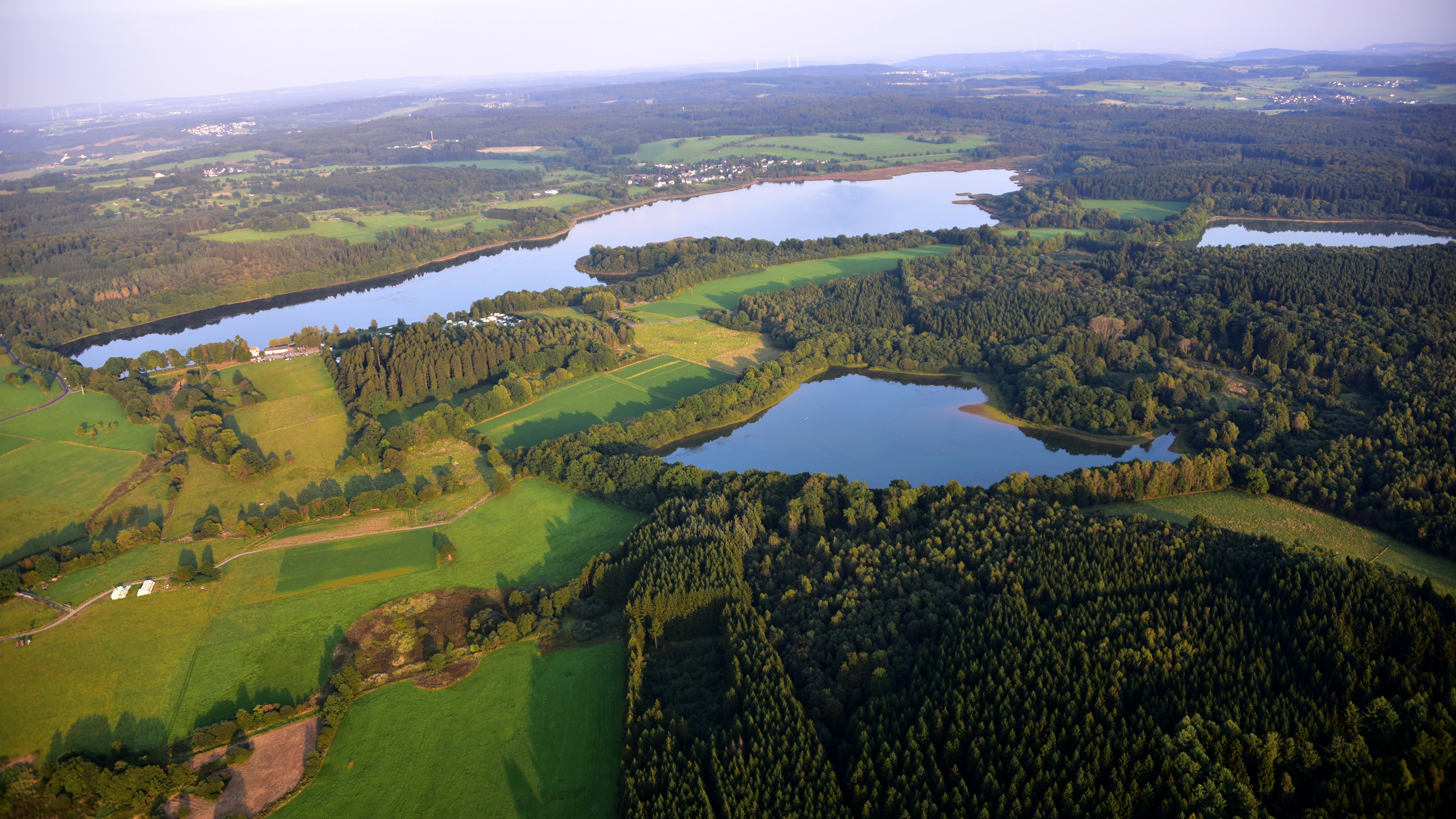
Aerial perspective looking down at a landscape of interconnected lakes, dense forests, and patches of green farmland in rural Germany.
An aerial view of the Westerwald lake plateau, featuring the Dreifelder Weiher and surrounding bodies of water.

Dreifelder Weiher history and protected-area timeline

Dreifelder Weiher is a human-made pond, constructed rather than natural in origin. Its basin was created after the Thirty Years' War by Count Friedrich III of Wied, who between the mid and late seventeenth century commissioned a group of six ponds in the partly marshy terrain of the northern Westerwald to support fish farming. At the same time, the existing hunting lodge of Haus Seeburg on the western shore was expanded into a more formal noble residence, anchoring the landscape as both a productive and recreational estate.

The wider Westerwald setting had long been a favoured hunting ground of the Wied family. The early nineteenth-century naturalist Prince Maximilian zu Wied carried out his first scientific expeditions in this same landscape, gaining the field experience that later informed his celebrated journeys through Brazil and North America and his pioneering documentation of American natural history.

In the modern era, the ponds of the Westerwälder Seenplatte were progressively recognised as valuable nature protection areas, with much of Dreifelder Weiher and its surroundings designated as protected zones for their rare flora and fauna. Their conservation importance was further reinforced when the waters were included in the European Fauna-Flora-Habitat network. In 2019, ownership of the Dreifelder Weiher and its sister ponds, totalling 228 hectares, was transferred to the NABU-Stiftung Nationales Naturerbe, marking a new chapter in their long-term conservation. By 2023, however, the lake faced serious ecological strain when a forced lowering of the water level for flood safety reasons disrupted breeding of waterbirds and the large population of common toads, exposing the pond's vulnerability to hydrological management decisions.

Dreifelder Weiher landscape and geographic character

Dreifelder Weiher lies in the rolling, mid-elevation landscape of the northern Westerwald, a low mountain region in western Germany characterised by rounded ridges, mixed woodland, meadow valleys, and a network of small streams. The pond occupies a broad, shallow basin at about 410 metres above sea level, stretching roughly two kilometres in length and almost a kilometre at its widest point, and is bordered by gently sloping shorelines rather than dramatic cliffs.

The visual character of the lake shifts with season and water level. In spring and early summer, the open water is framed by wide reedbelts along the margins, while small inlets and marshy edges create quiet transitional zones of sedges and rushes. Periodic drawdown of the water exposes broad muddy flats that, when reflooded, regenerate into dense stands of aquatic plants. The surrounding plateau landscape offers open vistas across forest clearings and pasture land, with the neighbouring villages of Dreifelden and Seeburg providing the only built-up focal points along the shoreline.

Geologically, the area belongs to the slate and quartzite formations typical of the Rhenish Massif, with thin soils that historically supported small-scale agriculture and fishpond cultivation rather than intensive land use. The result is a gentle, semi-natural landscape in which water, woodland, and farmland interlock across the broader Westerwälder Seenplatte.

Panoramic view of a large lake surrounded by marshland and distant forest under a clear blue sky.
A panoramic view of Dreifelder Weiher, the largest lake in the Westerwald Lake District.

Dreifelder Weiher ecosystems, habitats, and plant life

The pond and its surroundings are a textbook example of how traditional fishpond management can generate high ecological value. The most distinctive feature of Dreifelder Weiher is the presence of extensive stands of dwarf rush communities, rare formations of low-growing rush species that thrive under the cyclical wet and dry conditions created by the pond's drawdown and refilling or, more recently, by its intermittent drying.

Around the margins, broad reedbelts and sedge meadows form a continuous buffer between open water and the surrounding farmland and forest, providing habitat for amphibians, invertebrates, and breeding waterbirds. The European designation as a Fauna-Flora-Habitat site reflects the regional and national importance of these habitats for species that have become uncommon elsewhere in intensively used Central European landscapes.

The wider Westerwälder Seenplatte functions as a chain of complementary habitats, with each pond offering slightly different conditions based on its size, depth, and management. Together with the nearby Haidenweiher, to which Dreifelder Weiher is connected by a controlled outlet channel under nature protection status, the wetlands form a coherent ecological network within the Westerwaldkreis.
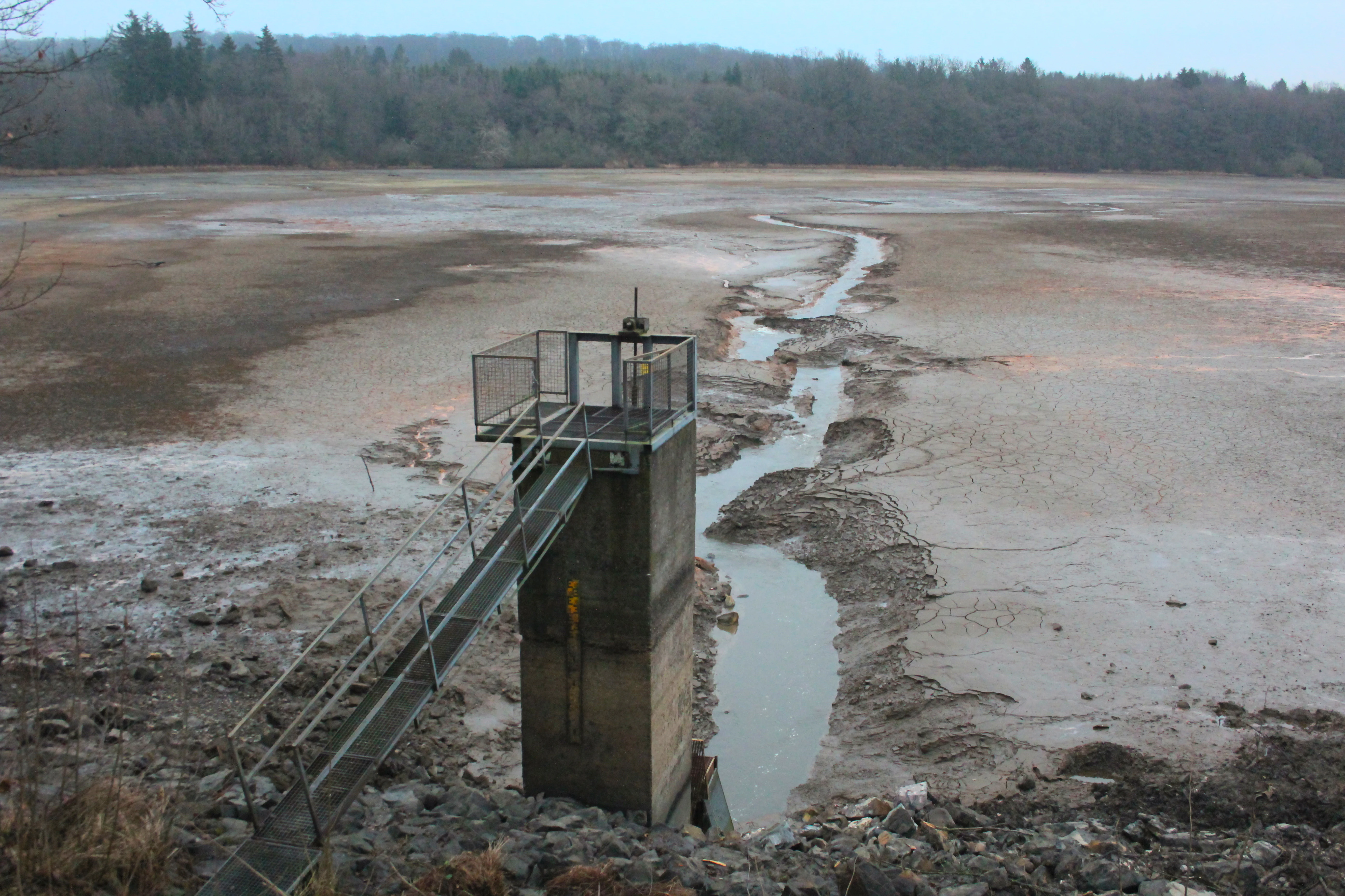
A wide shot of the drained Dreifelder Weiher lake bed, featuring a concrete sluice tower in the foreground and the Wied river flowing through the center towards a treeline in the background.
The Dreifelder Weiher during a drawdown, showing the river channel running through the exposed lake bed.

Dreifelder Weiher wildlife and species highlights

Dreifelder Weiher supports a community of waterbirds, amphibians, and wetland invertebrates shaped by the seasonal rhythm of the pond's water level. Historically, the lake hosted successful breeding of various waterfowl species, though recent years have seen sharp declines in nesting success as the water regime has been altered.

Amphibians are a particular feature of the site. Common toads have used the pond and its surrounding wet meadows in very large numbers, with recent estimates placing local populations in the thousands during peak breeding seasons. The shallow margins and temporary pools created by fluctuating water levels are crucial for their reproduction, making the species a key indicator of the lake's ecological condition.

The drawdown zones, when exposed, are colonised by specialised invertebrates and small aquatic life that depend on short-lived wet phases. Above the water, the reed and sedge zones provide shelter and nesting habitat for reed-associated birds, while the surrounding woodland and meadows are home to typical Westerwald species of songbirds, deer, and smaller mammals that move between forest edge and wetland.

Dreifelder Weiher conservation status and protection priorities

Dreifelder Weiher is one of the most important conservation sites within the Westerwaldkreis. Large portions of the lake and its surroundings are formally designated as nature protection areas, recognising their value for rare plants, amphibians, and waterbirds, and the broader Westerwälder Seenplatte has been incorporated into the European network of Fauna-Flora-Habitat sites, tying the pond into the wider Natura 2000 framework.

In 2019, ownership of Dreifelder Weiher together with the other ponds of the lake district, covering roughly 228 hectares in total, was transferred to the NABU-Stiftung Nationales Naturerbe, a foundation focused on the long-term protection and ecological management of high-value natural sites across Germany. This change placed the lake under the stewardship of a major nature conservation organisation, reinforcing its protected status.

Conservation efforts have increasingly focused on the pond's hydrological management. By the early 2020s, ecological problems tied to water level changes, including the loss of nearly all successful waterbird breeding and the collapse of toad reproduction in some years, prompted funding for restoration of the historic outlet structure. These efforts underline the narrow balance between flood-risk management and the ecological needs of one of Rhineland-Palatinate's most valued wetland complexes.

Dreifelder Weiher cultural meaning and human context

The lake is rooted in the territorial and cultural history of the House of Wied. Dreifelder Weiher was built as part of a larger fish farming initiative by Count Friedrich III of Wied following the Thirty Years' War, while the small estate of Haus Seeburg on its western shore evolved from a hunting station into a noble residence for the dynasty. This connection with the Wied family remained visible in the landscape long after the original construction.

The region also occupies an unusual place in the history of natural science. Prince Maximilian zu Wied, of the same Wied dynasty, conducted his first natural history field studies in the Westerwald around Dreifelder Weiher before embarking on his celebrated scientific journeys through Brazil and the interior of North America. His careful work in this landscape prefigured the methods that would later make him an important figure in early nineteenth-century exploration and ethnography.

Today, the lake retains a quieter cultural presence through local tourism, including the campground at its northwestern shore and walking routes such as the 7-Weiher-Weg, a regional trail that links the seven ponds of the Seenplatte. The combination of aristocratic heritage, scientific legacy, and contemporary outdoor recreation gives the area a layered cultural identity beyond its natural values.

Top sights and standout views in Dreifelder Weiher

Dreifelder Weiher is the largest pond in the Westerwälder Seenplatte and among the most ecologically valuable stillwaters in Rhineland-Palatinate. Its combination of extensive reedbelts, rare dwarf rush communities, and protected status within the European Fauna-Flora-Habitat network sets it apart as a leading example of how historical fishponds can become modern conservation sites.

The lake is also a rare meeting point of cultural and natural heritage: a seventeenth-century noble fish farming landscape, the early natural history laboratory of Prince Maximilian zu Wied, and a present-day NABU-protected wetland, all in a single basin within the gentle highlands of the northern Westerwald.

Best time to visit Dreifelder Weiher

The character of Dreifelder Weiher shifts substantially through the year. Late spring and early summer, when water levels are typically higher and reedbelts are at their fullest, offer the most scenic experience of the lake as a wide, reed-fringed stillwater with strong waterbird activity. This period is also the most rewarding for observing amphibians around the wet meadow margins.

Late summer and early autumn often reveal a very different landscape: during the traditional annual drawdown of the pond to harvest fish, large muddy flats are exposed, reactivating rare plant communities such as dwarf rush swards and producing a striking contrast of bare sediment, regenerating vegetation, and reduced open water. Visitors interested in hiking and cycling routes such as the regional 7-Weiher-Weg generally find the surrounding paths accessible across the warmer months, while winter visits offer quieter, reflective views across the higher Westerwald plateau landscape.

Monthly climate preview

Long-term representative point measurements tracking monthly temperature and precipitation rhythm

Dreifelder Weiher Climate Normals and Measured Annual Temperature Patterns

Historical coordinate data records recorded temperatures ranging from negative sub-zero winter minimums to warm summer maximums alongside consistent daily precipitation throughout the year. Reviewing the complete twelve-month climatology profile provides deeper analytical context for long-term regional environmental research.
Annual mean9 °C
0 °C19 °C
Jan
Feb
Mar
Apr
May12°
Jun16°
Jul19°
Aug18°
Sep14°
Oct
Nov
Dec
Warmest month
July

18.5 °C

Coolest month
January

-0.4 °C

Wettest month
December

2.5 mm/day

Driest month
April

1.6 mm/day

Park location guide

Geography guide, regional context, and park location map for Dreifelder Weiher

Dreifelder Weiher park geography, regions, and map view in Germany

Understand where Dreifelder Weiher sits in Germany through a broader geographic reading of the surrounding landscape, nearby location context, and its mapped position within the national park landscape.

How Dreifelder Weiher fits into Germany

Germany is a federal republic in Western and Central Europe with a population of over 83 million across sixteen constituent states. It is Europe's largest economy by nominal GDP and a major global exporter and importer. The capital is Berlin, and the country borders Denmark, Poland, Czech Republic, Austria, Switzerland, France, Luxembourg, Belgium, and the Netherlands.

Wider geography shaping Dreifelder Weiher in Germany

Germany is located in Western and Central Europe, spanning 357,022 km². It borders Denmark to the north, Poland and the Czech Republic to the east, Austria and Switzerland to the south, and France, Luxembourg, Belgium, and the Netherlands to the west. The country has coastlines on the Baltic Sea and North Sea to the north, with the Alps located in the southern region.

Map view of Dreifelder Weiher

Use this park location map to pinpoint Dreifelder Weiher in Germany, understand its exact geographic position, and read its mapped placement within the surrounding landscape more clearly.

Pigeon | © OpenStreetMap contributors

Location context for Dreifelder Weiher

Rhineland-Palatinate

Visualizing shoreline habitats, reedbelts, and highland waters

Dreifelder Weiher Landscape and Scenery Photography

Photographic records reveal the distinct topography and aquatic habitats of Dreifelder Weiher across changing seasonal water levels. Visual documentation captures the wide reedbelts, shallow wetland basins, and surrounding forest margins that define this protected landscape.

Aerial perspective looking down at a landscape of interconnected lakes, dense forests, and patches of green farmland in rural Germany.

A wide, scenic view of a calm, blue lake in spring, surrounded by grassy banks, reeds, and deciduous trees under a clear blue sky with white clouds.

Panoramic view of a large lake surrounded by marshland and distant forest under a clear blue sky.

A wide shot of the drained Dreifelder Weiher lake bed, featuring a concrete sluice tower in the foreground and the Wied river flowing through the center towards a treeline in the background.

Park atlas

Compare regional wetlands, upland reserves, and neighboring protected areas

Explore Parks Near Dreifelder Weiher and Surrounding Protected Landscapes

Browsing other parks near Dreifelder Weiher reveals the wider network of wetland reserves and upland habitats across the northern Westerwald region. Comparing adjacent protected landscapes provides essential geographic context for understanding regional conservation patterns.
Nature reserveRheinland-Pfalz
About 1.6 km away#1 closest

Southeast

Westerwälder Seen: Nature Reserve Geography and Mapped Pond Landscape in Rhineland-Palatinate

Historic reservoir systems, wetland habitats, and upland plateau terrain

Westerwälder Seen is a sprawling nature reserve defined by its system of seven interconnected, man-made ponds and surrounding wetland fringes. Located in the heart of the Westerwald in Rhineland-Palatinate, this site serves as a prime example of historical land management evolving into a vital ecological refuge for waterbirds, amphibians, and diverse brook forest communities.

Area
2.28 km²
Established
1650
Relief
Upland
Climate
Temperate
A horizontal watercolor painting showing a calm lake or pond with grassy banks, small trees, and soft hills in the background.
Protected areaGermany
About 2.2 km away#2 closest

South

Brinkenweiher Protected Area and Westerwald Lake District Geography

Historic wetland habitat in Rhineland-Palatinate

Brinkenweiher serves as a significant example of a seventeenth-century Waldweiher, shaped by human engineering to dam the Holzbach headwaters. Today, the site functions as a protected nature reserve, offering a varied landscape of shadowed forest fringes, marshy wetlands, and open meadows that support a coherent wetland ecosystem within the broader Westerwälder Seenplatte.

Area
0.21 km²
Established
1660
Relief
Lowland
Scope
Terrestrial
Nature reserveWesterwaldkreis
About 4 km away#3 closest

Southeast

Wölferlinger Weiher Nature Reserve: Geography and Protected Wetland Boundaries

Historic Westerwaldkreis pond and protected aquatic landscape

Wölferlinger Weiher represents a critical protected wetland within the Westerwaldkreis region of Germany. This detailed record highlights the pond's geographic role within the Westerwälder Seenplatte, covering its marshy fringes, shallow water zones, and surrounding moist meadows that define its protected area status.

Area
0.9 km²
Established
1979
Relief
Lowland
Climate
Temperate
A soft, light watercolor painting of rolling green hills, scattered trees, and a winding path under a pale, warm sky.
Nature reserveWesterwaldkreis
About 11 km away#4 closest

South

Naturschutzgebiet Malberg: Geography and Protected Phonolite Landscapes in Westerwaldkreis

Geological exploration of a unique volcanic nature reserve

Naturschutzgebiet Malberg provides a focused look at a rare volcanic cupola in Germany. Centered on a 22-million-year-old phonolite summit, the reserve protects a complex environment of blockfields, craggy crevices, and natural rock caves that stand out as a sharp geographic anomaly amidst the gentle lowlands of the Montabaur Basin.

Area
0.96 km²
Established
1971
IUCN
IV
Relief
Mountain
A horizontal watercolor painting depicting a soft, scenic landscape of a park with rolling hills, a central body of water, and surrounding trees.
Nature reserveWesterwaldkreis
About 13 km away#5 closest

Northeast

Bacher Lay Nature Reserve: Basalt Quarry Landscapes in Westerwaldkreis, Germany

Protected landscape with significant geological geotope features

Bacher Lay provides an informative look at a compact nature reserve formed within a former basalt quarry. Featuring the striking Pfaffenmal columnar basalt formation and a mosaic of river valley habitats, the site serves as a vital protected area in the Westerwaldkreis region for studying habitat succession and geological formations.

Area
0.447 km²
Established
1996
IUCN
IV
Relief
Upland
Watercolor illustration of a winding stream flowing through a lush green valley with rolling hills in the background.
Nature reserveRheinland-Pfalz
About 15 km away#6 closest

East

Holzbachdurchbruch: Basalt Gorge and Protected Nature Reserve in the Westerwald Highlands

Geological landscapes and protected stream valleys in Rheinland-Pfalz.

The Holzbachdurchbruch nature reserve is a focused, high-relief landscape defined by its classic breakthrough valley where the Holzbach cuts through resistant basalt bedrock. This protected area offers a look at the volcanic terrain and forest-stream mosaics that define the Westerwald, serving as a landmark site for understanding the regional geography and geological heritage of Germany.

Area
0.21 km²
Established
1961
IUCN
IV
Relief
Upland
Watercolor painting of a soft, hazy landscape featuring rolling green hills, distant mountains, and water in the foreground.
Nature reserveWesterwaldkreis
About 19 km away#7 closest

East

Breitenbachtalsperre Nature Reserve: Geography and Protected Habitat Mapping in Westerwaldkreis

Managed wetland and reservoir landscape in western Germany

Breitenbachtalsperre protects an important reservoir ecosystem, including shallow margins and wet meadows near Waigandshain. This nature reserve provides a focused look at habitat management in the Westerwald, where stream-fed waters sustain diverse plant societies and wildlife in a compact, protected basin.

Area
0.47 km²
Established
1988
IUCN
IV
Nature reserveRheinland-Pfalz
About 20 km away#8 closest

East

Wacholderheide bei Westernohe Nature Reserve Protected Area Atlas and Geographic Map Context

Juniper heathland mosaic in the German Westerwald region

Spanning 14 hectares, Wacholderheide bei Westernohe acts as a vital protected pocket of open heathland framed by dense spruce forests. The reserve supports a specialized community of arnica, common heather, and juniper, sustained by decades of consistent grazing and mechanical mowing that define its unique regional character.

Area
0.14 km²
Established
1967
IUCN
IV

Common questions about visiting, size, designation, and location context for Dreifelder Weiher

Dreifelder Weiher FAQs for park facts, access, geography, and protected area context

Find quick answers about Dreifelder Weiher, including protected-area facts, park geography, trail and visitor context, and how the park fits into its surrounding country and regional landscape.
MoriAtlas Explorer

Continue Your Protected Areas Search Across the Global Atlas

Deepen your exploration by continuing the structured search for national parks and protected areas worldwide. Utilize the comprehensive filtering capabilities to compare different conservation landscapes and refine your understanding of global park geography. Discover more about the distribution and characteristics of protected natural areas.

Global natural geography