
Why Dybsø stands out
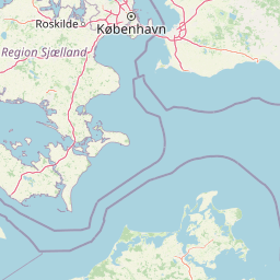
Dybsø is best known for its international importance as a feeding and resting ground for large flocks of ducks, geese, waders, and other waterbirds, set against a backdrop of open coastal meadows grazed by cattle and sheep. The island forms part of a double coastline with Enø that shelters Dybsø Fjord, producing shallow sandbanks rich in food for migratory birds. It is also recognized as a Ramsar wetland and EU bird protection area within the broader Natura 2000 network.
Dybsø history and protected-area timeline
Dybsø has a documented history stretching back to the Middle Ages. The island is first recorded in Kong Valdemars Jordebog, the medieval land register of King Valdemar, under the name Dyupsø. It was held by the Danish Crown before passing at the beginning of the seventeenth century to the Gavnø estate, where it remained for centuries. In the medieval and early modern period, Dybsø was settled, and around 1700 two farms stood on its northern part while much of the rest was under cultivation; traces of these older fields can still be seen in the southeastern part of the island.
After the farms were abandoned, the island became common grazing land (overdrev) used by cattle, sheep, and horses, setting the pattern of open, grazed meadows that still defines Dybsø today. Around 1920, the Danish writer and traveler Achton Friis visited Dybsø and wrote about the small Christensen family who were then living on the island along with four other residents. Until the mid-1960s, schoolchildren from the nearby villages of Svinø, Kostræde, and Køng were given an extra day off each year to watch the cattle being ferried by rowing boat across the narrow channel Strømmen, a vivid local tradition that illustrates how closely the island was tied to the surrounding communities.
The modern conservation history of Dybsø began in 1976, when the heirs of Baron Axel Reedtz-Thott sold the island to the Danish state. With Dybsø in public ownership, a renewed protection process was set in motion, and in 1978 the island was formally designated as a protected area. The protection order established that Dybsø must be preserved as grazing land (græsningsoverdrev) and may not be ploughed up for cultivation, while still guaranteeing the public right of access under Denmark's nature protection law. The narrow channel between Svinø and Dybsø, known as Dybsø Havn or Strømmen, remains an important artery for the warden of Dybsø, who still transports livestock to and from the island by boat using the small craft and a raft that are kept on the Zealand shore.
Dybsø landscape and geographic character
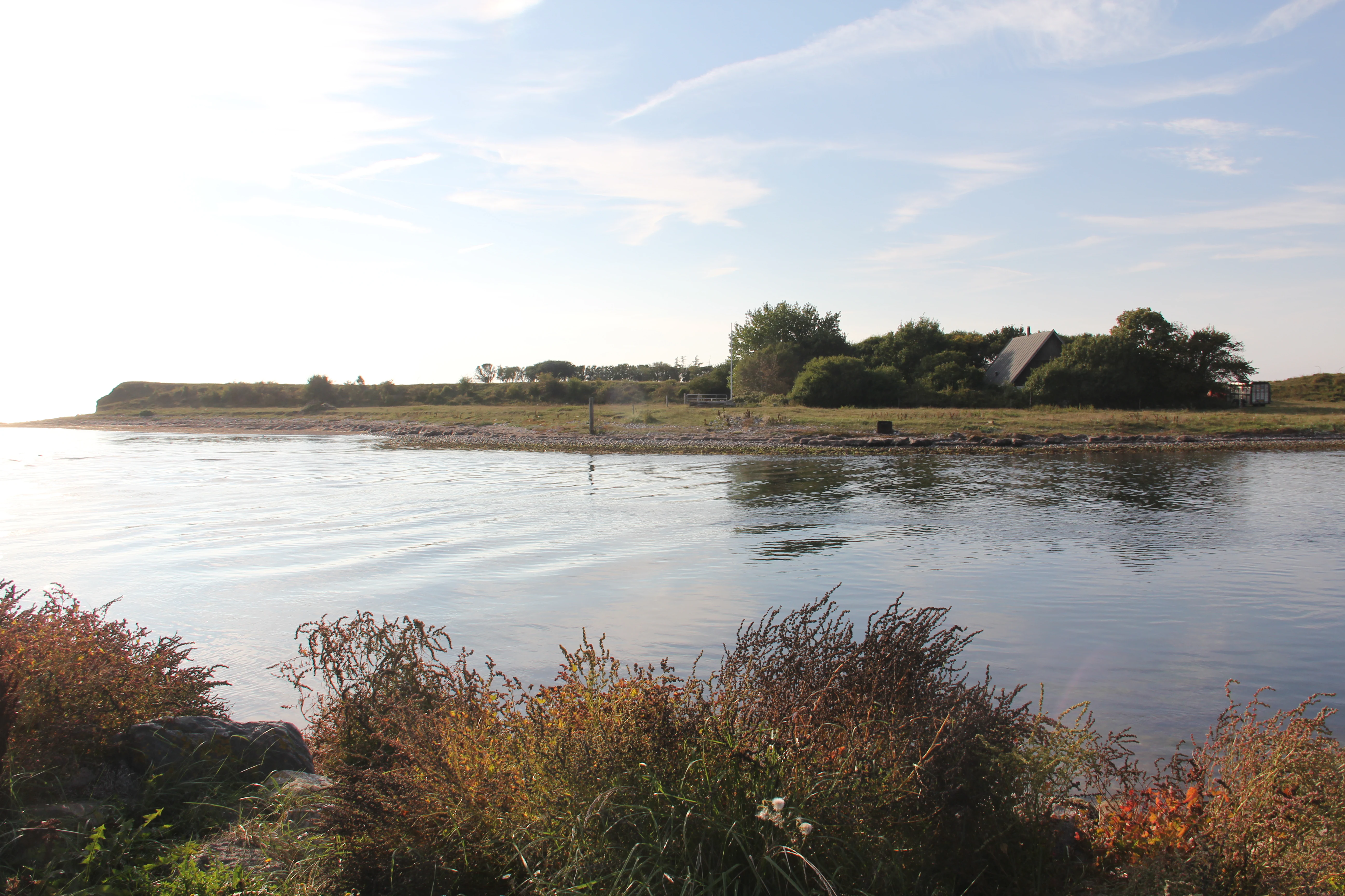
Dybsø has a characteristically flat, low island landscape typical of the Danish inner coastal waters. From north to south it stretches about three kilometers, and at its widest it is only about one kilometer across. The island never rises high: only at its two ends, toward Enø to the north and Svinø Land to the south, does the terrain lift into modest six-meter clay cliffs that drop down to the beach. The middle of the island is occupied by several small freshwater lakes, while the northern part consists of flat coastal meadows (strandenge).
The geological story of Dybsø is visible in the ground itself. The island's core is a moraine knoll, and the surrounding flat areas were built up over time as the sea deposited sand and other material in line with that knoll; the broad, flat stretch on the eastern side of Dybsø is the result of this natural land-building process. Today, Dybsø reads as an open, almost prairie-like coastal landscape shaped by wind, water, and grazing animals, with a horizon dominated by sky, sea, and the long line of the double coast that leads toward Enø in the north and Svinø in the south.
Dybsø ecosystems, habitats, and plant life
Ecologically, Dybsø is dominated by coastal meadows and reed beds, the classic habitats of the Danish barrier coast. The island's permanent grasslands are never ploughed, and their long continuity means the meadows have developed into a coherent habitat that would be very difficult to recreate once lost. Cattle and sheep graze the meadows each season, keeping woody plants from encroaching and maintaining the open structure that meadow birds depend on.
Away from the grazed meadows, the island holds a number of small freshwater ponds and stretches of reed swamp (rørsumpe) that hold water and provide cover for waterbirds. The surrounding sea is also an integral part of Dybsø's ecological setting: Dybsø Fjord and the Karrebæksminde Bugt are shallow, with extensive sandbanks and seagrass beds, and these nutrient-rich shallows support the enormous biomass of invertebrates and small fish that in turn attract wildfowl, waders, and predators. Within this wider framework, Dybsø sits inside a Natura 2000 area that is simultaneously classified as a bird protection area, an EU habitat area, and a Ramsar wetland, signaling that the island and its surrounding waters are recognized as internationally valuable habitat.
Dybsø wildlife and species highlights
Dybsø is primarily significant for its birdlife. The open coastal meadows, reed beds, and shallow waters around the island support rich populations of waterfowl including ducks, geese, swans, and coots, while the grazed meadows are important breeding grounds for waders such as redshank, oystercatcher, avocet, and lapwing. These concentrations of waterfowl and waders in turn attract raptors, and the island has notable occurrences of white-tailed eagle and peregrine falcon, both of which feed on the abundant bird life.
The island also hosts breeding colonies of terns and gulls, which are particularly sensitive to disturbance during the nesting season. To protect these vulnerable breeding birds, access to the northeastern part of Dybsø is closed to the public from 1 April until 15 July, although visitors can still see much of the island and its surroundings from the water. The combination of grazing land, freshwater ponds, reed beds, and open sea gives Dybsø a layered bird community, with different species using different parts of the island depending on the season.
Dybsø conservation status and protection priorities
Dybsø's conservation significance operates at several scales, from local management to international designation. At the most basic level, the island has been a protected area since 1978, when the Danish conservation order laid out that it should be preserved as continuous grazing land and not converted to arable use, while still retaining public access under Danish nature protection law. Grazing by cattle, and historically by sheep and horses, is itself the central management tool, and the continuity of that grazing is what maintains the open coastal meadows that make Dybsø biologically valuable.
The island is part of the Dybsø Fjord Wildlife Reserve (vildtreservat), where restrictions on hunting and limits on public access apply. It lies within Natura 2000 area number 169, covering the sea and coast between Karrebæk Fjord and Knudshoved Odde, and is designated as both a bird protection area (fuglebeskyttelsesområde) under the EU Birds Directive and an EU habitat area (EU-habitatområde) under the EU Habitats Directive. Finally, Dybsø is registered as a Ramsar area, recognizing it as a wetland of international importance under the Ramsar Convention. Restrictions on public access in the northeastern quarter of the island, in effect each year from 1 April to 15 July, are a direct conservation measure to reduce disturbance at the breeding colonies of waders, terns, and gulls.
Dybsø cultural meaning and human context
Dybsø's cultural footprint is modest but distinctive, rooted in the rhythms of rural South Zealand life. The island is first recorded in King Valdemar's medieval land register under the name Dyupsø, and has been part of Vejlø parish for centuries, connecting it to the religious and administrative life of the mainland. The medieval and post-medieval farms on the northern part of the island, and the faint traces of older cultivated fields in the southeast, mark a period of settlement that gradually gave way to a landscape of grazing common land.
The island's relationship with the surrounding villages is also part of its cultural identity. Until the middle of the 1960s, children from the nearby villages of Svinø, Kostræde, and Køng received an extra holiday each year to witness the annual event of cattle being rowed across the narrow channel Strømmen to graze on Dybsø, a striking example of how an island without a bridge was woven into the year of the local farming community. Achton Friis's early twentieth-century writings about visiting the small Christensen family and other residents of Dybsø preserve a literary memory of these everyday lives, and they continue to be referenced in Danish accounts of the island.
Top sights and standout views in Dybsø
Dybsø combines unusually powerful ecological signals with a strong and layered protection status. It is a Ramsar site, an EU bird protection area, an EU habitat area, and a national wildlife reserve all at once, while also being one of the clearest surviving examples of a Danish fed: permanent grasslands that have never been ploughed. The open, grazed coastal meadows, the freshwater ponds, the reed beds, and the surrounding shallow seas together support breeding waders and terns, large flocks of wintering and migrating waterfowl, and predators such as the white-tailed eagle and peregrine falcon.
Best time to visit Dybsø
The character of a visit to Dybsø changes meaningfully through the year. Spring and early summer bring breeding waders and tern colonies to the meadows and shores, but the northeastern quarter of the island is closed to public access from 1 April until 15 July in order to protect these sensitive nesting birds, and the meadows themselves are then in active grazing use. Late summer and autumn, after the breeding season closes and access restrictions end, offer a more open experience of the island, while autumn and winter bring the largest gatherings of ducks, geese, and swans to Dybsø Fjord, which is widely regarded as the most rewarding time to observe the area's waterfowl. Because the island is not served by regular ferries, visits depend on private or guided boat transport from the South Zealand coast.