
Mori Atlas logo
State or regional parkE. C. Manning Provincial Park

Mapping the dramatic ecological transition across alpine meadows and mountain river systems

E. C. Manning Provincial Park: An Atlas of Protected Landscapes in the Canadian Cascades

E. C. Manning Provincial Park protects a sweeping section of the Hozameen Range, acting as a crucial geographic corridor in southern British Columbia. This protected area reveals a compressed transition from wet coastal rainforests on western slopes to subalpine meadows and jagged peaks further inland. The terrain encompasses four major river systems, including the Skagit and Similkameen, and serves as a vital anchor point for mountain geography and wilderness research in the Canadian Cascades.

Cascade Mountainssubalpine meadowsCanadian CascadesHozameen Rangealpine wildflowersPacific Crest Trail

E. C. Manning Provincial Park

State or regional park

Park overview

Structured park overview, official facts, and landscape profile for E. C. Manning Provincial Park

E. C. Manning Provincial Park park facts, protected area profile, and essential visitor context

Review the core facts for E. C. Manning Provincial Park, including designation, size, terrain, visitor scale, habitats, and operating context in one park-focused overview.

About E. C. Manning Provincial Park

E. C. Manning Provincial Park is one of the signature mountain parks of British Columbia's interior-south region, occupying a long band of the Cascade Mountains immediately north of the United States border. The park stretches about 58 kilometres from its western portal near Hope to its eastern portal near Princeton, with Highway 3 threading through its heart. This cross-Cascade corridor places Manning at a meeting point between the wet ecosystems of the Pacific coast and the drier climates of the southern interior, producing a landscape of unusually strong contrast within a single protected area.

Most of the Hozameen Range, a sub-range of the Canadian Cascades, falls within the park's boundaries. The terrain rises from valley-bottom broad river beds and cedar-hemlock rainforests through rugged midslopes to jagged snow-capped summits and high subalpine meadows scattered with wildflowers and small lakes. Trails of varying length cross the park, several of them following older Indigenous travel and fur-trade routes that connected the Upper Similkameen Valley with the coast. Today, the park's trail network supports everything from short walks to multi-day backcountry excursions, and includes the northern terminus of the Pacific Crest Trail as well as older heritage routes such as the Dewdney and Allison Pass trails.

A long-established resort at the park's centre complements the surrounding wilderness. Manning Park Resort, with its lodge, cabins, restaurants, campgrounds, and ski operations, anchors the visitor experience and supports year-round use of the park. Together with Lightning Lake, where non-motorized boating and canoeing are central summer activities, the resort area forms the focal point for park tourism. Manning is consistently one of the most-visited provincial parks in British Columbia, a status that reflects both the accessibility afforded by Highway 3 and the range of ecosystems and recreational opportunities the park contains.

Beyond recreation, Manning is ecologically meaningful as a protected span of the Canadian Cascades and as a refuge for wildlife species that depend on intact Cascade habitat. The park hosts substantial populations of black bears and mule deer, healthy populations of marmots and ground squirrels, and more than two hundred recorded bird species, while amphibians such as the coastal tailed frog and the Columbia spotted frog occupy its wet forest and stream environments. Major rivers including the Skagit, Sumallo, Skaist, and parts of the Similkameen originate in or flow through the park, linking Manning hydrologically to both Puget Sound and the Okanagan basin and reinforcing its importance as a Cascade watershed protector.

Quick facts and research context for E. C. Manning Provincial Park

E. C. Manning Provincial Park lies in southern British Columbia, in the Cascade Mountains between Hope to the west and Princeton to the east, with its core area very close to the U.S. border. It is a Class A Provincial Park managed by BC Parks and governed under IUCN Category II protected-area standards, reflecting national-park-level protection intent.

The landscape spans the Hozameen Range and ranges from wet coastal rainforests on the west through subalpine meadows and snow-capped peaks to drier interior valleys on the east. The park is crossed by Highway 3, supports the northern terminus of the Pacific Crest Trail, and contains multiple major rivers including the Skagit, the Sumallo, the Skaist, and headwaters of the Similkameen.

Protection and recognition

Documented terrestrial protection metrics and official administrative scope

E. C. Manning Provincial Park Protection Status and Conservation Scope

E. C. Manning Provincial Park maintains a documented terrestrial protection framework covering its regional landscape. Comprehensive protected area data details the administrative scope and conservation status associated with the reserve.

Protection details

Protection scope
Terrestrial
Transboundary protection
No
Park context

Deeper park guide and search-rich context for E. C. Manning Provincial Park

E. C. Manning Provincial Park history, landscape, wildlife, and travel context

Explore E. C. Manning Provincial Park through its history, landscape character, ecosystems, wildlife, conservation priorities, cultural context, and seasonal travel timing in a structured park guide built for atlas discovery and search intent.

Why E. C. Manning Provincial Park stands out

Manning Park is best known for its midsummer displays of subalpine flowers in the high meadows along the Skyline Trail and neighbouring routes, a widely celebrated seasonal feature of the park. The park is also recognized for the dramatic ecological transition it preserves, moving within a short road drive from temperate coastal rainforest through mountain passes into the dry interior of British Columbia. Beyond its flora, the park is known for Lightning Lake, a popular non-motorized boating and canoeing destination set against the surrounding Cascade peaks, and for the cross-border connection to the Pacific Crest Trail, which begins (or ends) its Canadian stretch here. Together, alpine wildflower meadows, varied forest ecosystems, and signature Cascade scenery form the core of what makes Manning distinct.
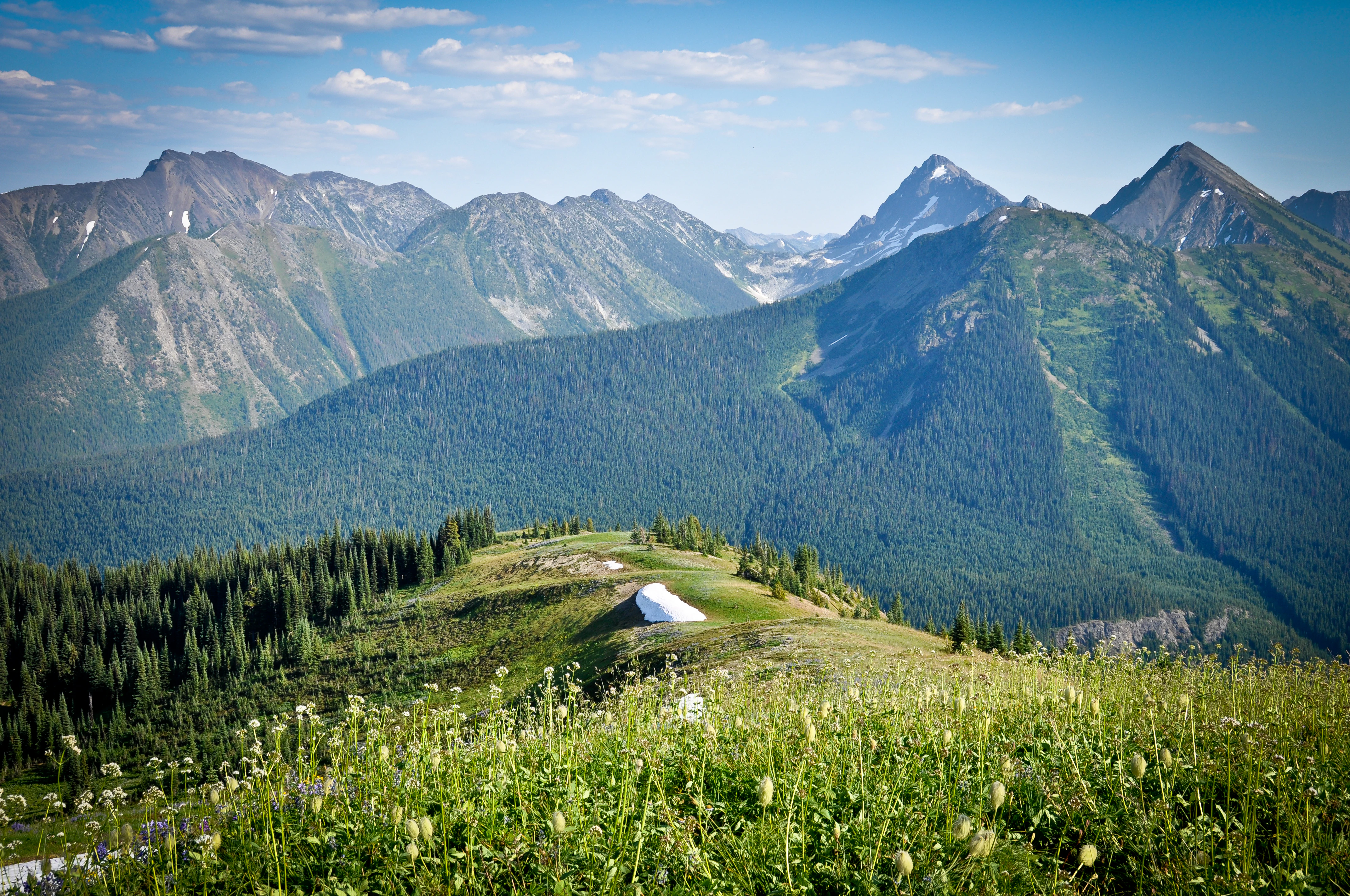
Hozameen Range
View of the Hozameen Range from Snow Camp Mountain in E. C. Manning Provincial Park

E. C. Manning Provincial Park history and protected-area timeline

The earliest human use of the park's landscapes was by the Indigenous peoples of coastal British Columbia, who travelled along routes that would later be formalized as the Skyline Trail to reach the Upper Similkameen Valley. The first European contact in the area dates to 1813, with Archibald McDonald exploring and mapping the region in 1827. Access through the Cascades remained extremely limited for decades; aside from the Dewdney Trail far to the north, there were no developed roads or trails across these mountains before the Great Depression, leaving the Manning region largely isolated from road-based travel.

Formal protection began modestly. In 1931 the Three Brothers Mountain Reserve was created to prevent overgrazing, and in 1936 it was re-designated the Three Brothers Game Reserve. In 1941, the area became Three Brothers Mountain Park, a Class A Provincial Park. The construction of the Hope–Princeton highway, which now bisects the park along Highway 3, was initiated in 1929 as an unemployment relief project but stalled. During the Second World War, interned Japanese Canadians were among the workers who pushed the road to completion, which it reached in 1949. The route largely follows the older Allison Pass Trail, constructed in 1859 and 1860.

The park was renamed in memory of Ernest Callaway Manning, British Columbia's Chief Forester from 1936 to 1941, who died in an airplane accident in 1941. Manning, working with Minister of Lands Arthur Wellesley Gray, helped establish several of British Columbia's foundational parks, including Tweedsmuir, Hamber, and Wells Gray, in addition to what became E. C. Manning. The mid-century shift toward motoring-based recreation shaped the park's development: the Hope–Princeton highway opened up the Cascades to family road travel, and the Parks Branch deliberately protected the visual quality of vistas along the route. Over the decades, the park has lost some of its original extent, most notably at its eastern boundary, where mine claims and private land have pushed the boundary several kilometres west, removing areas such as Similkameen Falls from the protected area.

E. C. Manning Provincial Park landscape and geographic character

Manning Park's terrain is a compressed cross-section of the Canadian Cascades. Much of the Hozameen Range, a rugged sub-range of the Cascades, lies within the park, and the elevations rise from broad valley floors to jagged, snow-capped summits. On the wetter western side the slopes carry coastal rainforests of western hemlock and western red cedar, while across the high passes the forests thin into subalpine parkland and open meadows bright with summer wildflowers.

The park's intermediate elevations feature a chain of small lakes and, in season, broad swaths of alpine and subalpine flowering meadows. A notable special feature is Rhododendron Flats near the park's western entrance, which hosts a large colony of pinkish-red rhododendrons that flower in early to mid-June, a protected and unusually visible bloom in this part of the Cascades.

Manning's hydrology is equally varied. Four named river systems flow from the park's meadows, passes, and ridges: the Skagit, originating at Allison Pass and running southwest toward Puget Sound; the Sumallo, which joins the Skagit within the park; the small Skaist; and the Similkameen, a major tributary of the Okanagan River that begins on the western slopes of Nicomen Ridge in the north of the park. Together these river corridors link Manning to vastly different downstream regions, from the marine waters of Washington State to the dry interior lakes of the Okanagan.
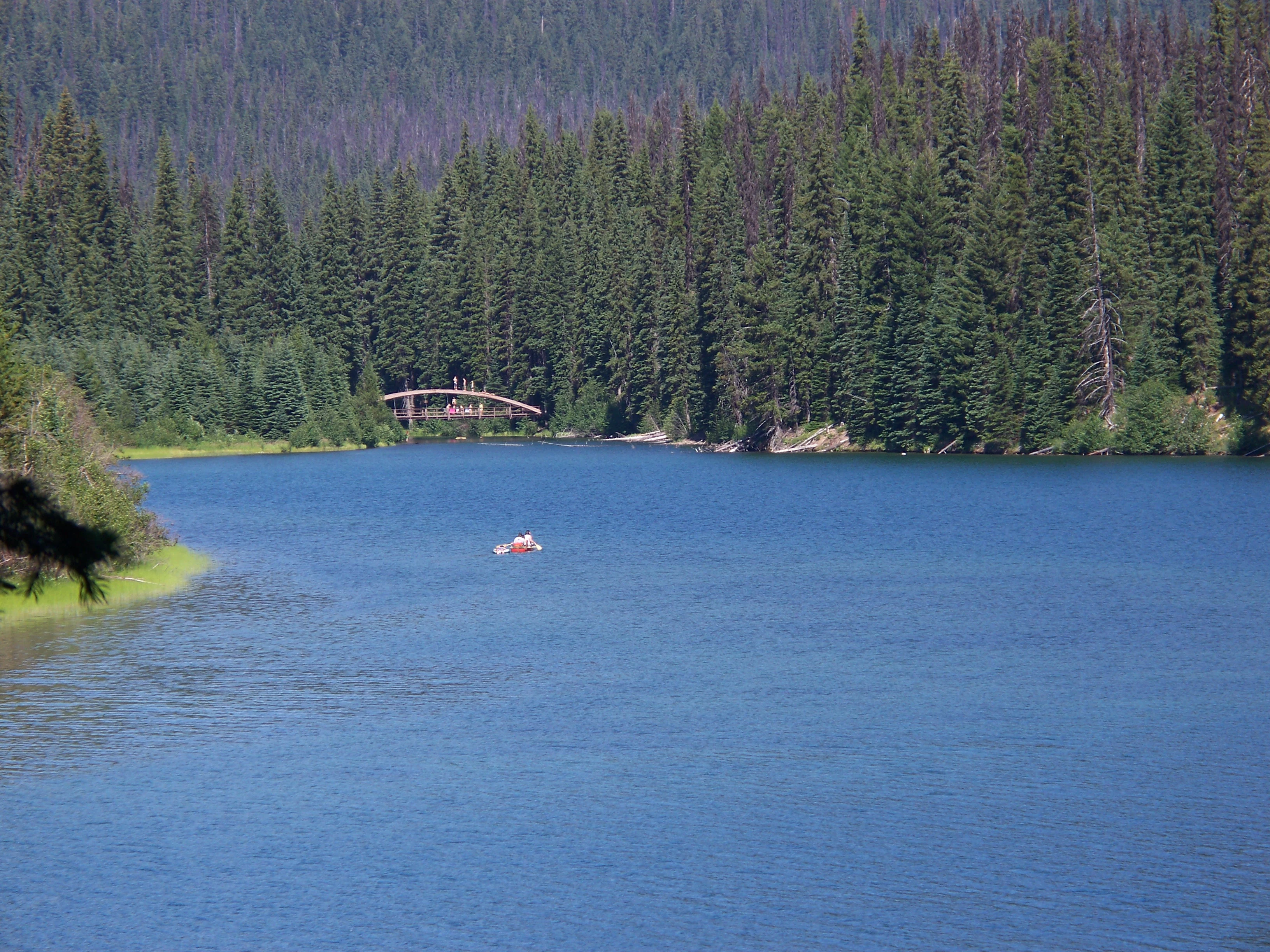
Lightning Lake Canoe
A canoe on Lightning Lake in E. C. Manning Provincial Park

E. C. Manning Provincial Park ecosystems, habitats, and plant life

Manning Park protects a sharp ecological gradient across the Cascade Mountains. On its western side, the climate is wet and temperate, supporting coastal rainforests dominated by western hemlock and western red cedar, with mossy understoreys and a rich riparian network. Moving eastward across Allison Pass, conditions become drier and more continental, and the vegetation transitions toward the more open, fire-adapted forests typical of British Columbia's southern interior.

Between these extremes lies a band of high-elevation subalpine environments. Summer brings fields of flowering plants to the park's meadows, with the midsummer subalpine bloom being one of the park's most celebrated ecological events. Mosaic patterns of meadow, rock, krummholz, and small tarns create habitat complexity that supports a wide range of wildlife, including small mammals, breeding birds, and amphibians tied to wet microhabitats. The park's elevation range and west-to-east moisture gradient give it unusually high ecological diversity for a single protected area of its size in this part of Canada.
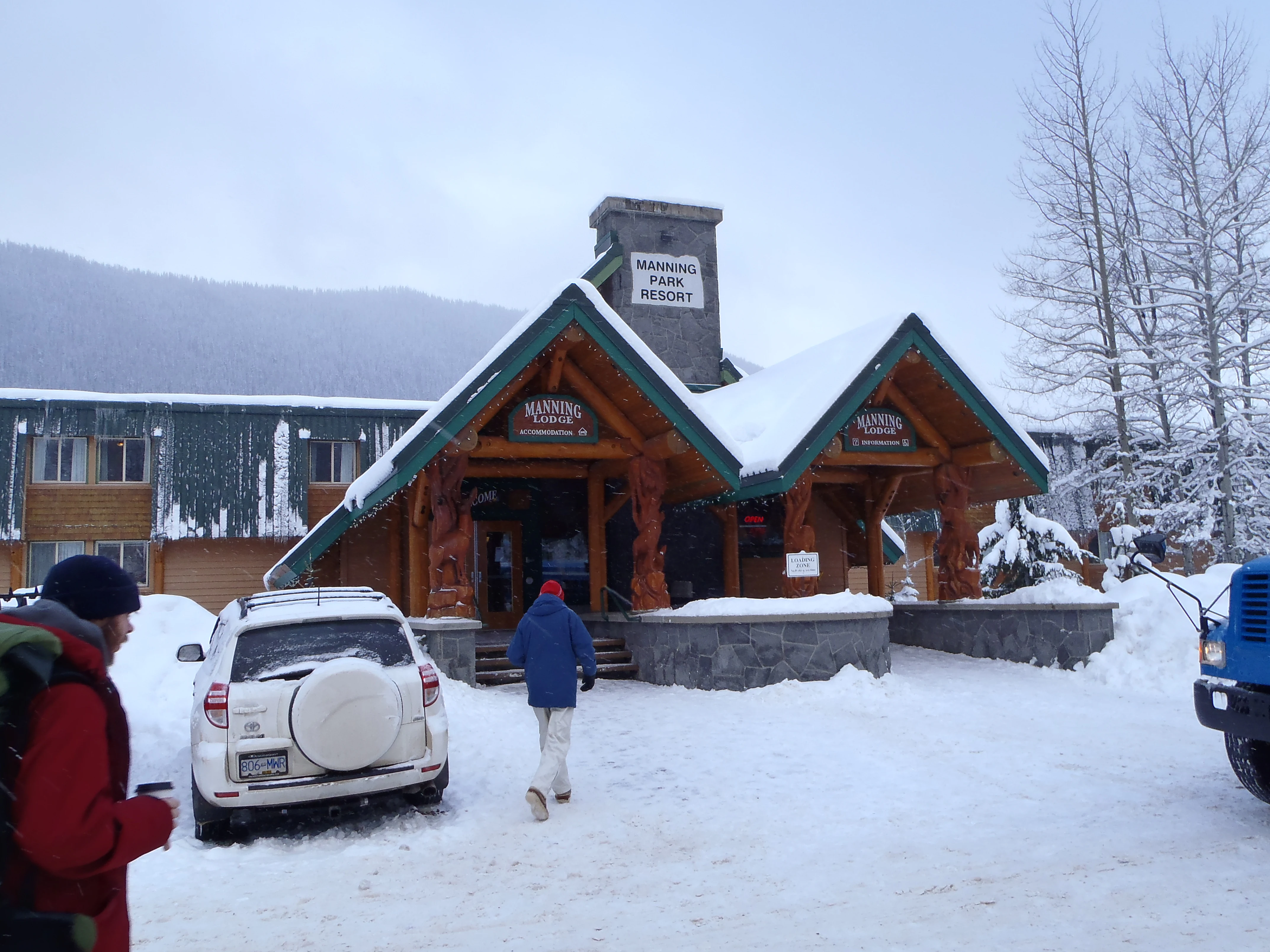
Pinewoods Store and Restaurant
Lodge building at Manning Park Resort

E. C. Manning Provincial Park wildlife and species highlights

Manning Park supports a rich and varied fauna drawn from both coastal and interior ecosystems. More than two hundred bird species have been recorded during the Manning Park Bird Blitzes that have been held since 1983, reflecting both the park's habitat diversity and its location along important bird movement corridors in the southern Cascades. Among larger mammals, black bears and mule deer are widely present across the park, and the alpine and subalpine zones are home to hoary marmots, yellow-bellied marmots, and Columbian ground squirrels.

The park also hosts a notable amphibian and reptile community, including the coastal tailed frog, the Columbia spotted frog, the western toad, the Pacific treefrog, the long-toed salamander, three species of gartersnake, and the alligator lizard. Although not formally documented, species such as the rubber boa, red-legged frog, and cascades frog are thought likely to occur within the park. Among the less common species the park aims to protect are the mountain beaver, a moist-forest specialist, and the wolverine, a wide-ranging carnivore associated with intact high-elevation terrain.

Mountain panorama view
A panoramic view from a mountain summit in E. C. Manning Provincial Park

E. C. Manning Provincial Park conservation status and protection priorities

Manning Park's conservation value comes from its scale and from the ecological transitions it preserves. As a large Class A Provincial Park managed under high-level protection standards, it safeguards a substantial portion of the Hozameen Range and the cross-Cascade habitat corridor linking coastal and interior ecosystems. The park protects headwaters and major sections of rivers that flow into two distinct larger systems, the Skagit watershed draining to Puget Sound and the Similkameen, contributing to the Okanagan.

Conservation in the park has not been without compromise. Logging has occurred multiple times throughout Manning's history, reflecting an older park-management philosophy that prioritized scenic quality over ecological protection. The park has also seen boundary losses, particularly on its eastern side, where mine claims and private land have pushed the boundary several kilometres west. Despite these pressures, the park's broader ecosystems remain relatively intact, supporting species such as the wolverine and the mountain beaver, and providing a refuge of contiguous Cascade habitat at a time when many similar landscapes in the region are heavily fragmented.

E. C. Manning Provincial Park cultural meaning and human context

The cultural layering of Manning Park begins with the Indigenous history of the landscape. The Skyline Trail corridor and connecting routes were used by coastal Indigenous peoples to reach the Upper Similkameen Valley well before any European contact, and these older travel ways are still reflected in the modern trail system. European and later Canadian history added further layers, including fur-trade-era travel, mid-nineteenth-century road-building, and the road-construction labour of interned Japanese Canadians during the Second World War, whose work completed the Hope–Princeton highway and opened the Cascades to road-based recreation.

The park is also significant in the history of conservation leadership in British Columbia. Ernest Callaway Manning, the park's namesake, was instrumental in establishing several of the province's foundational parks alongside Minister of Lands Arthur Wellesley Gray. The development of the resort area in the 1950s and the subsequent expansion of ski operations also reflected a mid-twentieth-century debate over who parks were for, eventually resolving in favour of broad public access. These threads together give Manning a layered cultural identity rooted in Indigenous travel, settler conservation policy, wartime labour, and the rise of outdoor recreation in post-war Canada.

Top sights and standout views in E. C. Manning Provincial Park

Manning Park's strongest landmarks are concentrated along its Cascade spine. The subalpine meadows, especially those along the Skyline Trail corridor, deliver the park's signature midsummer wildflower displays, while Rhododendron Flats near the western entrance adds an early-summer bloom of protected rhododendrons to the seasonal calendar. Lightning Lake anchors the visitor experience with non-motorized boating and easily accessible shoreline trails.

The park's high points also include its role as the northern terminus of the Pacific Crest Trail, the passage of Highway 3 through Allison Pass, the dramatic Hozameen Range scenery from summits such as Snow Camp Mountain, and the network of rivers, including the Skagit and Similkameen headwaters, that connect the park to vastly larger regional watersheds. The Manning Park Resort, with its long development history and the Gibson Pass Ski Area, adds a recreation focus that complements the wilderness setting.

Best time to visit E. C. Manning Provincial Park

Manning Park rewards visits at almost any time of year, but its most distinctive seasons align with the flowering cycle of its subalpine meadows. Early to mid-June is the season of the protected rhododendrons at Rhododendron Flats near the western entrance, while midsummer brings the widely celebrated subalpine wildflower displays in the higher meadows, a time when hiking above the valley is at its most photogenic. Summer is also the favoured season for Lightning Lake canoeing and kayaking, and for the longer backcountry routes that follow the Skyline and park-spanning trails.

Winter transforms the park into a snow landscape with its own identity. The Gibson Pass Ski Area at the resort operates roughly from December through March, while the surrounding forests and frozen lakes provide space for cross-country skiing, snowshoeing, and quiet winter scenery. Spring and shoulder seasons bring rapidly changing conditions as snowmelt reshapes rivers and high-country access reopens gradually, offering particularly striking transitions between ecosystems across the park.

Park guides

Targeted advisory resources addressing optimal timing and seasonal transitions across the Cascade mountain terrain

E. C. Manning Provincial Park Published Guides and Focused Planning Resources

Selected published guides provide focused answers regarding optimal timing for alpine wildflower viewing and winter recreation across the protected park landscape. Readers can consult specific seasonal planning resources to evaluate peak summer trail windows and snow-covered terrain conditions.
Monthly climate preview

Long-term representative point measurements of monthly temperature and precipitation patterns

E. C. Manning Provincial Park Climate Normals and Annual Temperature Rhythm

Representative coordinate records for E. C. Manning Provincial Park reveal a measured annual cycle of shifting temperatures and precipitation rates from negative winter means to warmer summer peaks. Detailed monthly normals provide deeper insight into long-term climate trends across this protected area.
Annual mean1 °C
-8 °C12 °C
Jan-7°
Feb-7°
Mar-5°
Apr-2°
May
Jun
Jul12°
Aug12°
Sep
Oct
Nov-4°
Dec-8°
Warmest month
August

12.4 °C

Coolest month
December

-7.8 °C

Wettest month
November

5.7 mm/day

Driest month
August

1.2 mm/day

Park location guide

Geography guide, regional context, and park location map for E. C. Manning Provincial Park

E. C. Manning Provincial Park park geography, regions, and map view in Canada

Understand where E. C. Manning Provincial Park sits in Canada through a broader geographic reading of the surrounding landscape, nearby location context, and its mapped position within the national park landscape.

How E. C. Manning Provincial Park fits into Canada

Canada is a federal parliamentary constitutional monarchy spanning North America from the Atlantic to the Pacific and Arctic Oceans. With a population of over 41 million, it is officially bilingual in English and French at the federal level. The country gained independence from the United Kingdom through a gradual process culminating in 1982.

Wider geography shaping E. C. Manning Provincial Park in Canada

Canada occupies the northern portion of North America, sharing its longest international border with the United States. The country extends from the Atlantic Ocean to the Pacific Ocean and northward into the Arctic Ocean, giving it the longest coastline of any nation.

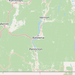
Map view of E. C. Manning Provincial Park

Use this park location map to pinpoint E. C. Manning Provincial Park in Canada, understand its exact geographic position, and read its mapped placement within the surrounding landscape more clearly.

Pigeon | © OpenStreetMap contributors

Location context for E. C. Manning Provincial Park

British Columbia
Natural feature types

Trace the Natural Landscapes of E. C. Manning Provincial Park

Continue your geographic exploration by browsing the specific landforms and water bodies situated across E. C. Manning Provincial Park. This index offers a detailed view of the physical components that shape the park, from high-alpine meadows to deep river valleys, as mapped in the MoriAtlas database.
Recorded earthquake history

Examine the Recorded Earthquake History for E. C. Manning Provincial Park

Review the historical catalogue of seismic events recorded in the vicinity of E. C. Manning Provincial Park. This collection provides transparent access to documented epicentres and related data from the surrounding region, helping to provide geographic context for seismic history in this mountain landscape.

E. C. Manning Provincial Park Earthquake History

Catalogued events

13 events

Strongest magnitude

Magnitude 3.5

Most recent event

Jul 19, 2025

This history includes earthquakes recorded inside the park or within 50 km of its borders

Visual reference of Canadian Cascade terrain, subalpine meadows, and protected habitats.

E. C. Manning Provincial Park Photos and Landscape Scenery Exploration

Visual documentation captures the rugged mountain terrain, alpine wildflower meadows, and coastal rainforest transitions across the protected reserve. Detailed photographic records reveal the distinct ecological zones and geographic character of the Canadian Cascades.

Hozameen Range

Hiking into the alpine meadow

Lightning Lake Canoe

Pinewoods Store and Restaurant

Mountain panorama view

Park atlas

Compare adjacent mountain terrain, alpine meadows, and connected regional reserves

Exploring Parks Near E. C. Manning Provincial Park and Surrounding Protected Landscapes

Visitors exploring E. C. Manning Provincial Park can continue browsing nearby protected areas across the Canadian Cascades. Comparing adjacent mountain terrain and regional river valleys provides broader context on southern British Columbia wilderness.
Protected landscapeWashington
Park boundaries overlap#1 closest

Southeast

Okanogan, Wenatchee National Forest: A Comprehensive Look at Washington's Protected Mountain Landscapes

Mapping ecological gradients and wilderness boundaries across the eastern Cascade Range

Spanning from the moist coniferous forests of the western Cascades to the arid plateaus of the Okanogan, this massive national forest protects an unmatched diversity of terrain. Explore the intricate geography of river-carved valleys, glacial cirques, and remote wilderness areas that characterize this critical environmental corridor in the Pacific Northwest.

Area
6,066.33 km²
Established
1911
Visitors
397K annual
Relief
Mountain
Protected landscapeWashington
Park boundaries overlap#2 closest

Southwest

Ross Lake National Recreation Area: A Glacial Reservoir Landscape in Washington

Mapping the Skagit River and North Cascades alpine corridor

Located in the heart of Washington, Ross Lake National Recreation Area preserves a unique landscape of connected reservoirs and deep, glacier-cut valleys. This protected area acts as a vital geographic link within the North Cascades, offering access to high-altitude peaks, riverine forests, and the distinct turquoise waters of Diablo Lake.

Area
475.81 km²
Established
1968
IUCN
V
Visitors
998K annual
National parkWashington
6.9 km away#3 closest

Southwest

North Cascades National Park: US National Park Protected Landscape and Geographic Context

Explore mapped boundaries and regional Washington geography.

Gain insight into North Cascades National Park, a vital US National Park located in Washington. This entry focuses on its protected land status, mapped geographic extent, and its role within the regional atlas. Users seeking to understand the park's landscape character, natural terrain, and its specific location in Washington will find this an essential point for detailed park geography exploration and protected area discovery.

Area
2,042.26 km²
Established
1968
IUCN
II
Visitors
16.5K annual
State or regional parkBritish Columbia
17 km away#4 closest

Northwest

Coquihalla Canyon Provincial Park: A Deeply Eroded Granite Gorge in British Columbia

Mapping historic railway tunnels and river canyon landscapes

Trace the winding Coquihalla River as it cuts through ancient volcanic and metamorphic bedrock. This park preserves a unique intersection of industrial heritage and river morphology, showcasing four iconic tunnels bored through solid granite that define this section of the British Columbia interior landscape.

Area
1.59 km²
Established
1986
IUCN
III
Relief
Upland
Protected landscapeBritish Columbia
About 29 km away#5 closest

North

Coquihalla Summit Recreation Area: A Protected Landscape in the British Columbia Mountains

Mapping ecological transition zones and mountain terrain

Covering 5,750 hectares of rugged slopes and high-elevation ridges, Coquihalla Summit Recreation Area anchors a vital ecological transition between the coastal and interior climates of British Columbia. This mapped protected area offers a deep look into the granite peaks of the North Cascades and the historic remnants of transportation corridors spanning over a century.

Area
57.5 km²
Established
1987
Relief
Mountain
Scope
Terrestrial
State or regional parkBritish Columbia
32 km away#6 closest

Northwest

Emory Creek Provincial Park: Protected River Valley Landscapes in British Columbia

Historical boomtown site within the Fraser Canyon corridor

Located on the western bank of the Fraser River, Emory Creek Provincial Park preserves a landscape shaped by nineteenth century gold rushes and Canadian Pacific Railway construction. This protected area offers insight into the forested riverside terrain and historical geography that define one of the most storied corridors in southern British Columbia.

Established
1956
IUCN
II
Water
Major water bodies
Protected landscapeWashington
36 km away#7 closest

South

Mount Baker, Snoqualmie National Forest: Mapped Geography and Protected Landscape Analysis

Exploratory atlas of Washington's primary Cascade Range wilderness

Delve into the structural geography of Mount Baker, Snoqualmie National Forest. This protected area corridor serves as a major ecological transition zone between the Puget Sound lowlands and the interior Cascades, characterized by extensive glaciers, wild river systems, and iconic stratovolcanoes that define the regional landscape of Washington state.

Area
6,978 km²
Established
1974
Relief
Mountain
Climate
Alpine
Wildlife reserveWashington
36 km away#8 closest

West

Mount Baker Wilderness: Mapped Volcanic Peaks and Glacial Geography in Washington State

Protected wilderness boundaries in the Northern Cascades

Mount Baker Wilderness encompasses a vast mountain landscape characterized by an active stratovolcano and significant permanent snowfields. The terrain features a vertical gradient from dense west side conifer forests to exposed alpine summits, creating a distinct ecological corridor connected to neighboring protected areas in the Pacific Northwest.

Area
485.58 km²
Established
1984
IUCN
Ib
Relief
Mountain

Common questions about visiting, size, designation, and location context for E. C. Manning Provincial Park

E. C. Manning Provincial Park FAQs for park facts, access, geography, and protected area context

Find quick answers about E. C. Manning Provincial Park, including protected-area facts, park geography, trail and visitor context, and how the park fits into its surrounding country and regional landscape.
MoriAtlas Explorer

Continue Your Protected Areas Search Across the Global Atlas

Deepen your exploration by continuing the structured search for national parks and protected areas worldwide. Utilize the comprehensive filtering capabilities to compare different conservation landscapes and refine your understanding of global park geography. Discover more about the distribution and characteristics of protected natural areas.

Global natural geography