Mori Atlas logo
Wildlife reserveEaglenest Wildlife Sanctuary

Examining the altitudinal gradients and forest corridors of a vital Indian wildlife reserve

Eaglenest Wildlife Sanctuary: Mapped Protected Landscapes in the West Kameng Himalayan Foothills

Eaglenest Wildlife Sanctuary encompasses a critical expanse of closed-canopy forest within the West Kameng district of Arunachal Pradesh, India. This protected area bridges low-lying foothill zones with temperate mountain ridges, creating a steep altitudinal gradient that supports diverse habitats ranging from tropical broadleaf stands to rhododendron forests. As part of a larger interconnected forest complex, the sanctuary serves as a vital ecological corridor for Asian elephants, red pandas, and a vast array of Himalayan birdlife, reflecting the intricate geography of the Eastern Himalayas.

Himalayan foothillsbirding sanctuaryIndo-Burmese biodiversityclosed-canopy forestEastern HimalayasImportant Bird Area

Eaglenest Wildlife Sanctuary

Wildlife reserve

Park overview

Structured park overview, official facts, and landscape profile for Eaglenest Wildlife Sanctuary

Eaglenest Wildlife Sanctuary park facts, protected area profile, and essential visitor context

Review the core facts for Eaglenest Wildlife Sanctuary, including designation, size, terrain, visitor scale, habitats, and operating context in one park-focused overview.

About Eaglenest Wildlife Sanctuary

Eaglenest Wildlife Sanctuary is a protected area in the eastern Himalayan foothills of Arunachal Pradesh, in northeastern India. It lies within West Kameng District along the border with Bhutan, adjoining Sessa Orchid Sanctuary to the northeast and Pakke Tiger Reserve to the east across the Kameng River. Together these areas form a large block of mostly unbroken closed-canopy forest that is one of the most important biodiversity strongholds of the Eastern Himalayas.

The sanctuary occupies a roughly east-west rectangle bounded on the east by the Bhalukpong to Bomdila highway and on the north by Eaglenest Ridge and the reserved forests used by the Bugun community. Its western edge, along Bhutan, and its southern edge, near 27 degrees north, do not have sharp natural boundaries. The highest ridges of Eaglenest and Sessa rise to over 3,200 meters and act as the first major barrier to the Indian summer monsoon as it moves north from the Assam plains. As a result, the southern slopes receive very heavy rainfall while the northern slopes are noticeably drier, producing steep ecological contrasts over short distances.

A single unpaved road climbs from the base of the sanctuary all the way up to Eaglenest Pass at about 2,800 meters, giving researchers and visitors access to the full altitudinal range. This combination of high biodiversity, dramatic elevation change, and relative accessibility has made Eaglenest a focal site for ornithological research, primate discovery, and ecotourism in the Eastern Himalaya. Modern conservation attention has built on the work of researchers such as Ramana Athreya and Anwaruddin Choudhury, whose surveys here led to the recognition of the Bugun liocichla and the Arunachal macaque.

Quick facts and research context for Eaglenest Wildlife Sanctuary

Eaglenest Wildlife Sanctuary lies in West Kameng District, Arunachal Pradesh, within the Himalayan foothills on the edge of the Eastern Himalayas. It is classified as an IUCN Category IV protected area, a habitat and species management area, and is part of the Kameng Elephant Reserve and the broader Kameng protected area complex, which covers around 3,500 square kilometers across several sanctuaries and reserved forests.

The sanctuary spans roughly 218 square kilometers, with elevations running from about 500 meters in the lower foothills to more than 3,000 meters along the Eaglenest and Sessa ridges, creating a steep ecological gradient that supports very different habitats within a small area. It is administered by the Government of Arunachal Pradesh through the Shergaon Forest Division, with field offices at Singchung, Ramalingam, and Khellong.

Protection and recognition

Documented terrestrial protection scope, designation history, and governance records.

Eaglenest Wildlife Sanctuary Protection Status and International Recognition

Eaglenest Wildlife Sanctuary maintains a documented terrestrial protection scope within its regional landscape. Official records outline management jurisdiction, conservation mandates, and international recognition data without external assumptions.

Protection details

Protection scope
Terrestrial
Transboundary protection
No
Park context

Deeper park guide and search-rich context for Eaglenest Wildlife Sanctuary

Eaglenest Wildlife Sanctuary history, landscape, wildlife, and travel context

Explore Eaglenest Wildlife Sanctuary through its history, landscape character, ecosystems, wildlife, conservation priorities, cultural context, and seasonal travel timing in a structured park guide built for atlas discovery and search intent.

Why Eaglenest Wildlife Sanctuary stands out

Eaglenest is best known for its extraordinary bird diversity and for being the place where the Bugun liocichla was first encountered, a finding that later led to its formal description as a species new to science. The sanctuary has recorded well over 450 bird species, including all three Indian tragopans, hornbills, ibisbill, black-necked crane, Blyth's tragopan, and a long list of flycatchers, warblers, thrushes, and finches. The sanctuary's combination of altitudinal range, position as a monsoon barrier, and extensive intact forest gives it an unusually high concentration of Indo-Burmese and Himalayan bird species in a relatively compact area. Its mammal fauna is also noteworthy, with red panda, Asiatic black bear, clouded leopard, marbled cat, and one of the highest known summer ranges for wild Asian elephants in India.
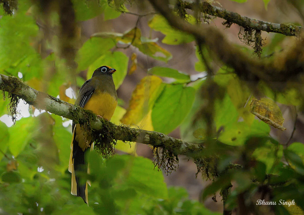
A Ward's Trogon bird with a yellow chest and long tail feathers perched on a moss-covered tree branch surrounded by green leaves.
A Ward's Trogon perched on a mossy branch in the Eaglenest Wildlife Sanctuary.

Eaglenest Wildlife Sanctuary history and protected-area timeline

Eaglenest Wildlife Sanctuary was formally established in 1989 as a protected area under the Government of Arunachal Pradesh. It takes its unusual name from the Red Eagle Division of the Indian Army, which was based in the area during the 1950s; the surrounding forests later became associated with that division in local memory and were eventually given formal protection status.

The sanctuary has gained much of its international reputation through scientific discoveries made there in the 1990s and 2000s. In 1995, a then-unknown species of liocichla was observed at Eaglenest, later named the Bugun liocichla and formally described in 2006 by Ramana Athreya. A new primate, the Arunachal macaque, was first identified in the area in 1997 by Anwaruddin Choudhury and described as a new species in 2004. These discoveries focused global conservation interest on Eaglenest as a site of ongoing biological novelty rather than a fixed historical endpoint.

Since its establishment, the sanctuary has been managed by the state forest department, currently through the Divisional Forest Officer of the Shergaon Forest Division, supported by field offices at Singchung, Ramalingam, and Khellong. The Critical Ecosystem Partnership Fund, Conservation International, and BirdLife International have all recognized the area as a global conservation priority, designating it as part of the Himalaya Biodiversity Hotspot and an Important Bird Area.

Eaglenest Wildlife Sanctuary landscape and geographic character

Eaglenest lies at the western end of a continuous block of Himalayan foothill forest that includes Sessa Orchid Sanctuary, Pakke Tiger Reserve, and the forests along the Kameng River. The terrain is shaped by the meeting of lowland plains with the rising front of the Eastern Himalaya. The southern portion of the sanctuary drops down through warm broadleaf forest toward the Assam plains, while the northern portion rises into steep ridges and damp temperate forest.

The dominant landforms are the Eaglenest and Sessa ridges, which run roughly east-west and rise to about 3,250 meters and 3,150 meters respectively. These ridges form the first physical barrier to the southwest monsoon, forcing moist air to rise sharply. The result is an unusually steep rainfall gradient, with the southern slopes receiving over 3,000 millimeters of rain a year and the northern slopes closer to 1,500 millimeters. Streams fed by this rainfall drain into the Kameng River system on the east and into tributaries of the Brahmaputra on the western side.

An unpaved road climbs from the base of the sanctuary up to Eaglenest Pass at around 2,800 meters, crossing through tropical foothill forest, mid-elevation moist forest, bamboo stands, and temperate ridges. This single corridor exposes nearly the entire range of habitats that the sanctuary protects, and it is one of the main reasons why such a steep gradient of life is concentrated in a relatively small area.

Close up of a rounded, textured puffball fungus releasing a cloud of brown spores into the air, set against a dark background with moss in the foreground.
A puffball fungus releasing spores in Eaglenest Wildlife Sanctuary.

Eaglenest Wildlife Sanctuary ecosystems, habitats, and plant life

The vegetation of Eaglenest changes dramatically with elevation, creating a compressed sequence of Eastern Himalayan forest types within a protected area of only about 218 square kilometers. At the lower end, around 500 meters, the forest includes warm broadleaf types characteristic of the Assam plains margin, while higher slopes transition through subtropical and then moist temperate forest. The canopy is generally closed and intact, and the sanctuary contains large tracts of old forest with bamboo understory in many sections.

Because the Eaglenest and Sessa ridges are the first major monsoon barrier in this part of the Himalaya, they support both wet southern slopes and drier northern slopes, producing a mosaic of microhabitats. The area is known for its rich plant diversity, including extensive stands of nettles such as Dendrocnide sinuata, locally known by a name that gives Sessni Camp its meaning. Orchid-rich forest patches connect Eaglenest ecologically with the adjoining Sessa Orchid Sanctuary.

Eaglenest forms part of the Kameng protected area complex, which together spans from roughly 100 meters to over 3,300 meters in altitude and includes the largest contiguous closed-canopy forest block in Arunachal Pradesh. This connectivity allows wide-ranging species to move seasonally between deep lowland forest and high ridges, reinforcing the sanctuary's ecological value as a transition zone between Indo-Burmese and Himalayan biogeographic regions.
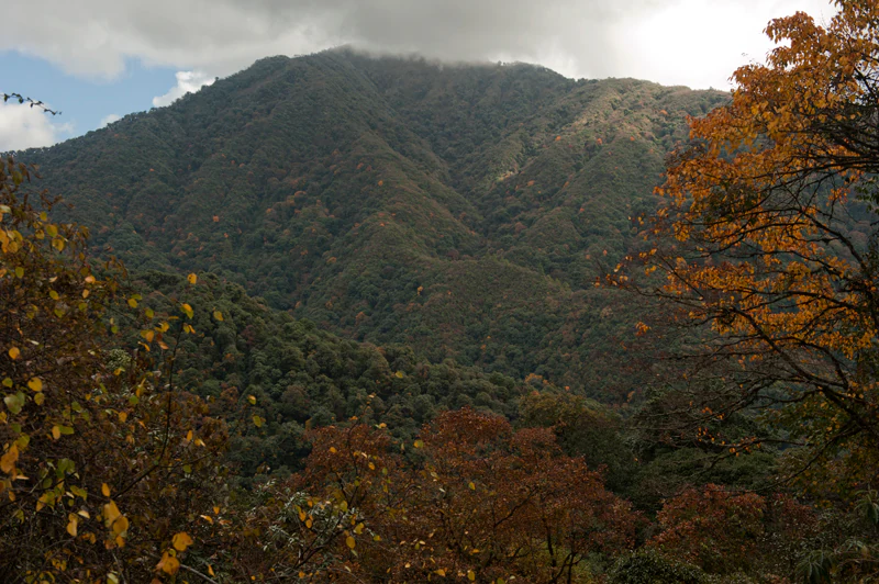
A wide view of a densely forested mountain ridge in the Himalayan foothills, framed by autumn-colored foliage in the foreground.
A view of the forested mountain slopes within Eaglenest Wildlife Sanctuary, seen from the Sunderview area.

Eaglenest Wildlife Sanctuary wildlife and species highlights

The wildlife of Eaglenest is most famous for its birds, with well over 450 recorded species. The sanctuary holds pheasants and tragopans including all three Indian tragopan species, hornbills, the ibisbill, the black-necked crane, the Oriental white ibis, the black stork, the Ward's trogon, and numerous thrushes, flycatchers, warblers, and finches. The Bugun liocichla, a songbird first observed here in 1995 and formally described in 2006, is the sanctuary's signature species and a key focus of conservation attention.

Mammal diversity is also substantial for such a compact area. The sanctuary supports clouded leopard, marbled cat, Asian golden cat, and leopard cat among the small and medium felids, along with Asiatic black bear, red panda, capped langur, Arunachal macaque, and gaur. The Arunachal macaque was first identified in 1997 from this general area and later described as a new species. Wild Asian elephants use Eaglenest extensively in summer and are believed to reach the Eaglenest ridge at around 3,250 meters, possibly the highest altitude recorded for elephants in India.

Reptile and amphibian life is also rich. Surveys have recorded at least 34 amphibian species, 24 snake species, and 7 lizard species, including significant rediscoveries such as the Abor Hills agama, found at Eaglenest after a gap of 125 years. The butterfly fauna includes at least 165 species, with striking species such as the Bhutan glory and a number of forest butterflies that depend on intact canopy habitat for their survival.

Eaglenest Wildlife Sanctuary conservation status and protection priorities

Eaglenest Wildlife Sanctuary is recognized internationally as a conservation priority of the highest tier. It lies within the Himalaya Biodiversity Hotspot identified by Conservation International, falls inside a Critical Ecosystem Partnership Fund critical region, and is jointly designated with Sessa as BirdLife International Important Bird Area IN344, with Blyth's tragopan noted as a vulnerable flagship species for the area.

The sanctuary's conservation significance goes beyond its species list. It is a core component of the Kameng protected area complex, the largest contiguous block of closed-canopy forest in Arunachal Pradesh, which connects Eaglenest with Pakke, Sessa, Nameri, and Sonai Rupai sanctuaries and associated reserve forests. This connectivity is essential for wide-ranging species such as elephants, cats, and bears, allowing them to move across elevation zones and across the reserves with relatively little fragmentation.

Practical protection is limited by the sanctuary's remoteness and the poor quality of its single access road, which also acts as a deterrent to timber and wildlife poaching. Management is delivered by the state forest department through the Shergaon Forest Division, supported by field offices at Singchung, Ramalingam, and Khellong. The absence of permanent settlement inside the sanctuary has historically shielded it from hunting pressure, but growing encroachments on the Assam side have intensified elephant-human conflict in the surrounding plains and put greater pressure on the high-elevation forest that elephants depend on during the summer months.

Eaglenest Wildlife Sanctuary cultural meaning and human context

The Eaglenest area is closely tied to the indigenous Bugun community, whose reserved forests lie along the northern boundary of the sanctuary near the Lama Camp area. The community has deep cultural and subsistence connections to the surrounding forests, and protection of the sanctuary has been shaped by the relationship between local highland communities and the migratory wildlife, including elephants, that move through the area in different seasons.

To the south, the foothill corridor connects Eaglenest culturally and economically with communities along the Bhalukpong-Bomdila highway, including groups whose languages and traditional practices reflect the transition between Assam plains culture and the Himalayan world further north. Local place names recorded in the area, including the Nepali-language origin of Sessni Camp, reflect this layered cultural geography built up from trade routes, army postings, and long-standing interactions between highland and lowland communities.

Top sights and standout views in Eaglenest Wildlife Sanctuary

Eaglenest's standout qualities are its extreme density of birdlife, its compact but dramatic altitudinal range, and its role as a site of modern biological discovery. The sanctuary has produced two globally significant species new to science, the Bugun liocichla and the Arunachal macaque, and continues to be a benchmark for research on the avifauna of the Eastern Himalayas.

Just as importantly, Eaglenest anchors a vast connected forest system across Arunachal Pradesh and gives Asian elephants, red pandas, and clouded leopards room to roam between lowland and highland habitats. For visitors and researchers, the steep transition from warm broadleaf forest at the base to rhododendron and bamboo ridges near the pass makes it possible to experience several Himalayan forest worlds in a single day.

Best time to visit Eaglenest Wildlife Sanctuary

Because Eaglenest is heavily influenced by the monsoon, the most comfortable and ecologically rewarding periods to experience the sanctuary are generally the drier months between late autumn and early spring, when roads are more passable and bird activity along the ridges is high. Winter brings altitudinal migrants, pheasants, and large numbers of thrushes, flycatchers, and warblers down to the lower and middle elevations, often producing excellent birdwatching conditions.

During and immediately after the monsoon, the southern slopes become extremely wet and leech-infested, and the unpaved road can be difficult to use, although the forest itself is at its lushest. Avoiding the heaviest monsoon weeks is advisable for general visitors, while researchers targeting amphibians, butterflies, and breeding birds often find the post-monsoon transition particularly productive.


Monthly climate preview

Long-term monthly temperature and precipitation data for West Kameng

Eaglenest Wildlife Sanctuary Climate Normals and Annual Weather Patterns

Representative coordinate records show measurable shifts in average temperature and precipitation across the annual cycle at Eaglenest Wildlife Sanctuary. Examining the complete twelve-month climate profile provides detailed historical baseline metrics for this protected area.
Annual mean19 °C
11 °C24 °C
Jan11°
Feb14°
Mar17°
Apr21°
May23°
Jun24°
Jul24°
Aug24°
Sep23°
Oct20°
Nov17°
Dec13°
Warmest month
August

24.4 °C

Coolest month
January

11.5 °C

Wettest month
July

10.1 mm/day

Driest month
December

0.2 mm/day

Park location guide

Geography guide, regional context, and park location map for Eaglenest Wildlife Sanctuary

Eaglenest Wildlife Sanctuary park geography, regions, and map view in India

Understand where Eaglenest Wildlife Sanctuary sits in India through a broader geographic reading of the surrounding landscape, nearby location context, and its mapped position within the national park landscape.

How Eaglenest Wildlife Sanctuary fits into India

India is a South Asian country bordered by the Indian Ocean, Arabian Sea, and Bay of Bengal. It shares land borders with Pakistan, China, Nepal, Bhutan, Bangladesh, and Myanmar. The country has a population of over 1.4 billion people and operates as a federal parliamentary republic with its capital in New Delhi.

Wider geography shaping Eaglenest Wildlife Sanctuary in India

India occupies the Indian subcontinent in South Asia, bordered by the Arabian Sea to the southwest, the Bay of Bengal to the southeast, and the Indian Ocean to the south. It shares land borders with Pakistan to the west, China, Nepal, and Bhutan to the north, and Bangladesh and Myanmar to the east. The territory also includes the Andaman and Nicobar Islands in the Indian Ocean.

Map view of Eaglenest Wildlife Sanctuary

Use this park location map to pinpoint Eaglenest Wildlife Sanctuary in India, understand its exact geographic position, and read its mapped placement within the surrounding landscape more clearly.

Pigeon | © OpenStreetMap contributors

Location context for Eaglenest Wildlife Sanctuary

Arunachal PradeshWest Kameng

Visualizing Himalayan foothill terrain, closed canopy forest, and diverse mountain habitats

Eaglenest Wildlife Sanctuary Photos and Landscape Scenery

Photographic archives reveal the rugged terrain and steep altitudinal gradients of Eaglenest Wildlife Sanctuary across the Eastern Himalayas. Visual documentation highlights closed canopy forests and diverse protected habitats that support rich avian and mammal populations.

A Ward's Trogon bird with a yellow chest and long tail feathers perched on a moss-covered tree branch surrounded by green leaves.

A detailed 19th-century style illustration showing two Blyth's tragopan birds in a lush, rocky stream-side forest habitat.

Close up of a rounded, textured puffball fungus releasing a cloud of brown spores into the air, set against a dark background with moss in the foreground.

A wide view of a densely forested mountain ridge in the Himalayan foothills, framed by autumn-colored foliage in the foreground.

Park atlas

Compare connected Himalayan forest reserves and regional sanctuaries

Parks Near Eaglenest Wildlife Sanctuary And Protected Landscapes

Browse other parks near Eaglenest Wildlife Sanctuary to examine connected forest tracts and adjacent Himalayan wildlife reserves. Continuing into surrounding protected areas reveals broader regional conservation patterns and mapped terrain variations.
Wildlife reserveArunachal Pradesh
About 15 km away#1 closest

Northeast

Sessa Orchid Sanctuary: Himalayan Foothills Wildlife Reserve and Mapped Protected Landscape

High-altitude forest geography in Arunachal Pradesh

Sessa Orchid Sanctuary is a pivotal wildlife reserve spanning the rugged Himalayan foothills of West Kameng, Arunachal Pradesh. Defined by deep gorges and high ridges, the sanctuary protects one of the most significant orchid habitats in India, featuring over 200 distinct species within its closed-canopy monsoon forests. This protected area stands as a central link in the Kameng Protected Area Complex, representing a critical region for scientific research, endemic flora, and continuous forest conservation.

Area
100 km²
Established
1989
IUCN
IV
Relief
Mountain
National parkSonitpur
About 40 km away#2 closest

East

Nameri National Park: A Protected Landscape within Sonitpur's Geography

Explore the mapped terrain and national park boundaries.

Nameri National Park represents a significant protected natural area, contributing to the regional geography of Sonitpur, India. This page offers an atlas-oriented perspective, detailing the park's mapped landscape and its designation as a national park. Understand the geographic context and the protected land's specific identity within this mapped region.

Area
200 km²
Established
1978
IUCN
II
Relief
Mountain
Wildlife reserveTrashigang District
About 49 km away#3 closest

Northwest

Sakteng Wildlife Sanctuary: Protected Area and Wildlife Reserve in Bhutan's Trashigang District

Mapping the mountainous terrain and unique temperate ecosystems.

Sakteng Wildlife Sanctuary is a vital protected area in eastern Bhutan, recognized as a wildlife reserve. Spanning approximately 742 square kilometers within Trashigang District, it features a dramatic mountainous terrain characterized by steep valleys and alpine meadows. The sanctuary's landscape transitions from forested slopes to subalpine conifer forests, representing Bhutan's easternmost temperate ecosystems and offering rich geographic context for atlas exploration.

Area
742.46 km²
Established
2003
IUCN
IV
Relief
Mountain
National parkAssam
About 61 km away#4 closest

South

Orang National Park: Assam's Key Floodplain Protected Landscape

Explore mapped boundaries and terrain context of this national park.

Orang National Park, located in Assam, India, is a significant protected area celebrated for its unique alluvial floodplain terrain and critical role in conservation. This national park provides a focused atlas-style view of grassland and wetland ecosystems, essential habitats for iconic species like the great Indian one-horned rhinoceros and Bengal tiger. Its geographical setting along the Brahmaputra River contributes to a dynamic landscape, offering rich context for understanding protected area distribution and regional natural features. Discover the mapped boundaries and ecological significance of this important protected land.

Area
78.81 km²
Established
1985
IUCN
II
Relief
Lowland
Wildlife reserveAssam
About 71 km away#5 closest

Southeast

Bura Chapori Wildlife Sanctuary: Protected Grassland Geography in the Brahmaputra Valley

A vital wildlife reserve and buffer area within Assam's floodplain ecosystem.

Located in the Sonitpur district of Assam, Bura Chapori Wildlife Sanctuary offers a focused look at the Brahmaputra valley's dynamic floodplain environment. This protected area supports an essential mosaic of open grasslands and riverine woodlands, serving as a critical corridor for large mammals and endangered grassland birds. Its geography is deeply influenced by the seasonal rhythms of the Brahmaputra River, shaping the sanctuary as both a wetland habitat and a key conservation link.

Area
44.06 km²
Established
1974
IUCN
IV
Relief
Lowland
Wildlife reserveAssam
About 73 km away#6 closest

Southwest

Bornadi Wildlife Sanctuary: Geographic Atlas and Protected Area Context in Assam

Mapping Himalayan foothill terrain and Indo-Bhutan border ecosystems.

Spanning the rolling foothills of Assam, Bornadi Wildlife Sanctuary represents a significant protected area focused on Himalayan fringe habitats. This geographic overview highlights the reserve's unique riverine corridors, mixed forest cover, and transitional grasslands that function as essential nodes in the broader conservation geography of northeastern India.

Area
26.22 km²
Established
1980
IUCN
IV
Relief
Upland
Watercolor painting of green hills, fields, and a body of water
National parkAssam
About 84 km away#7 closest

Southeast

Kaziranga National Park National Park: Protected Landscape and Geographic Atlas

Mapped boundaries and regional landscape context for this Assam natural area.

Delve into the detailed geographic profile of Kaziranga National Park, a prominent National Park located in Assam, India. This section focuses on its mapped protected area extent, its unique landscape characteristics within the Brahmaputra valley, and its role as a key natural landmark in northeastern India's atlas. Understand the structured geographic data and protected land identity that makes Kaziranga National Park a distinct entity for exploration.

Area
1,090 km²
Established
1905
IUCN
II
Relief
Lowland
Wildlife reserveArunachal Pradesh
About 117 km away#8 closest

East

Itanagar Wildlife Sanctuary: Hill Forest Reserve and Protected Landscape in Arunachal Pradesh

Exploring the dense evergreen geography of a key Indian wildlife reserve

Spanning 140 square kilometres, Itanagar Wildlife Sanctuary preserves a vital mosaic of tropical semi-evergreen and wet evergreen forest within the foothills of Arunachal Pradesh. Bounded by the Pachin, Pam, Neorochi, and Chingke streams, this protected area offers a unique juxtaposition of dense hill forest and urban edges, functioning as a significant biodiversity habitat in northeastern India.

Area
140.3 km²
Established
1978
IUCN
IV
Relief
Upland

Common questions about visiting, size, designation, and location context for Eaglenest Wildlife Sanctuary

Eaglenest Wildlife Sanctuary FAQs for park facts, access, geography, and protected area context

Find quick answers about Eaglenest Wildlife Sanctuary, including protected-area facts, park geography, trail and visitor context, and how the park fits into its surrounding country and regional landscape.
MoriAtlas Explorer

Continue Your Protected Areas Search Across the Global Atlas

Deepen your exploration by continuing the structured search for national parks and protected areas worldwide. Utilize the comprehensive filtering capabilities to compare different conservation landscapes and refine your understanding of global park geography. Discover more about the distribution and characteristics of protected natural areas.

Global natural geography