
Mori Atlas logo
Nature reserveEgelpfuhl bei Oberwetz

A mapped geographic sanctuary for threatened meadow flora and aquatic species within the Lahn-Dill district.

Egelpfuhl bei Oberwetz Nature Reserve: Protected Wetland Landscape in Central Hessen, Germany

(Naturschutzgebiet Egelpfuhl bei Oberwetz)

Egelpfuhl bei Oberwetz is a precisely defined nature reserve in the Schöffengrund municipality of Hessen, Germany, encompassing a small valley along the Dreisbach stream. This protected area functions as a critical node within the wider Feldflur bei Hüttenberg und Schöffengrund European bird protection area. Its landscape provides a mosaic of waterlogged meadows, willow thickets, and reeds, serving as a managed habitat for rare meadow plants and specialized fauna that thrive in high-moisture agricultural corridors.

wet meadownature reserveNaturschutzgebietHesseLahn-Dill districtSchöffengrund
Digital illustration of a mountain landscape featuring a river winding through a valley, a waterfall cascading down a cliff, and a forest of evergreen and deciduous trees.

Egelpfuhl bei Oberwetz

Nature reserve

Park overview

Structured park overview, official facts, and landscape profile for Egelpfuhl bei Oberwetz

Egelpfuhl bei Oberwetz park facts, protected area profile, and essential visitor context

Review the core facts for Egelpfuhl bei Oberwetz, including designation, size, terrain, visitor scale, habitats, and operating context in one park-focused overview.

About Egelpfuhl bei Oberwetz

Egelpfuhl bei Oberwetz lies in the southern part of the Lahn-Dill district in the German state of Hesse, nestled into a small agricultural landscape within the municipality of Schöffengrund. The reserve occupies a shallow valley drained by the Dreisbach, a small stream that flows westward and joins the Wetzbach only a few hundred meters downstream. On its eastern side the area borders the Landesstraße L 3054, while the surrounding land is dominated by farmland, giving the protected site a clear, locally embedded character within an actively used cultural landscape.

The core of the reserve is defined by wet and moist soils that sustain a network of small meadow patches interspersed with sedge stands, reeds, and tall herb fringes. Willow and alder shrubs line the near-natural course of the Dreisbach, adding structural diversity and supporting brookside fauna. This combination of open wet meadows, marginal tall herb vegetation, and riparian shrubs produces a habitat mosaic that is unusually rich for such a compact area.

Ecologically, the reserve functions as a key piece of the wider European bird protection area “Feldflur bei Hüttenberg und Schöffengrund.” It offers feeding and breeding habitat for meadow birds that depend on traditionally managed grasslands, and it also serves as a stepping stone for species that move between nearby woodland patches and open agricultural land. The combination of its official protection status, integration into the Natura 2000 framework, and targeted management makes Egelpfuhl bei Oberwetz a practical example of landscape-scale conservation built from small, well-chosen pieces of habitat.

Quick facts and research context for Egelpfuhl bei Oberwetz

Egelpfuhl bei Oberwetz is a designated nature reserve (Naturschutzgebiet) located in the Lahn-Dill district of Hesse, Germany, within the municipality of Schöffengrund. The site covers approximately 10.75 hectares at elevations between 283 and 298 meters and protects a small valley of wet meadows and brookside thickets along the Dreisbach.

It was placed under formal protection on 19 September 1990 under the designation code 1532024 and is administered by the upper nature conservation authority at the Regierungspräsidium Gießen. The reserve is recognized internationally in the World Database on Protected Areas (WDPA ID 162847) as an IUCN Category IV area, and it is integrated into the European bird protection area “Feldflur bei Hüttenberg und Schöffengrund.”

Protection and recognition

Documented conservation status, management scope, and official designation registry data

Egelpfuhl bei Oberwetz Protection Status and International Recognition Records

Comprehensive protected area records outline the official designation history and administrative framework established for Egelpfuhl bei Oberwetz. Evaluated source registries compile verified protection parameters to support structured geographical analysis.

Protection details

WDPA ID
162847
Park context

Deeper park guide and search-rich context for Egelpfuhl bei Oberwetz

Egelpfuhl bei Oberwetz history, landscape, wildlife, and travel context

Explore Egelpfuhl bei Oberwetz through its history, landscape character, ecosystems, wildlife, conservation priorities, cultural context, and seasonal travel timing in a structured park guide built for atlas discovery and search intent.

Why Egelpfuhl bei Oberwetz stands out

Egelpfuhl bei Oberwetz is best known for its richly structured wet meadow mosaic in a small valley setting, which provides a refuge for threatened meadow-dependent plant and animal species. The reserve is particularly associated with occurrences of the dark large blue butterfly (Dunkler Wiesenknopf-Ameisenbläuling), the European turtle dove, the northern lapwing, the common snipe, and a suite of rare wetland plants such as bog sedge (Schwarzschopf-Segge) and broad-leaved marsh orchid (Breitblättriges Knabenkraut).
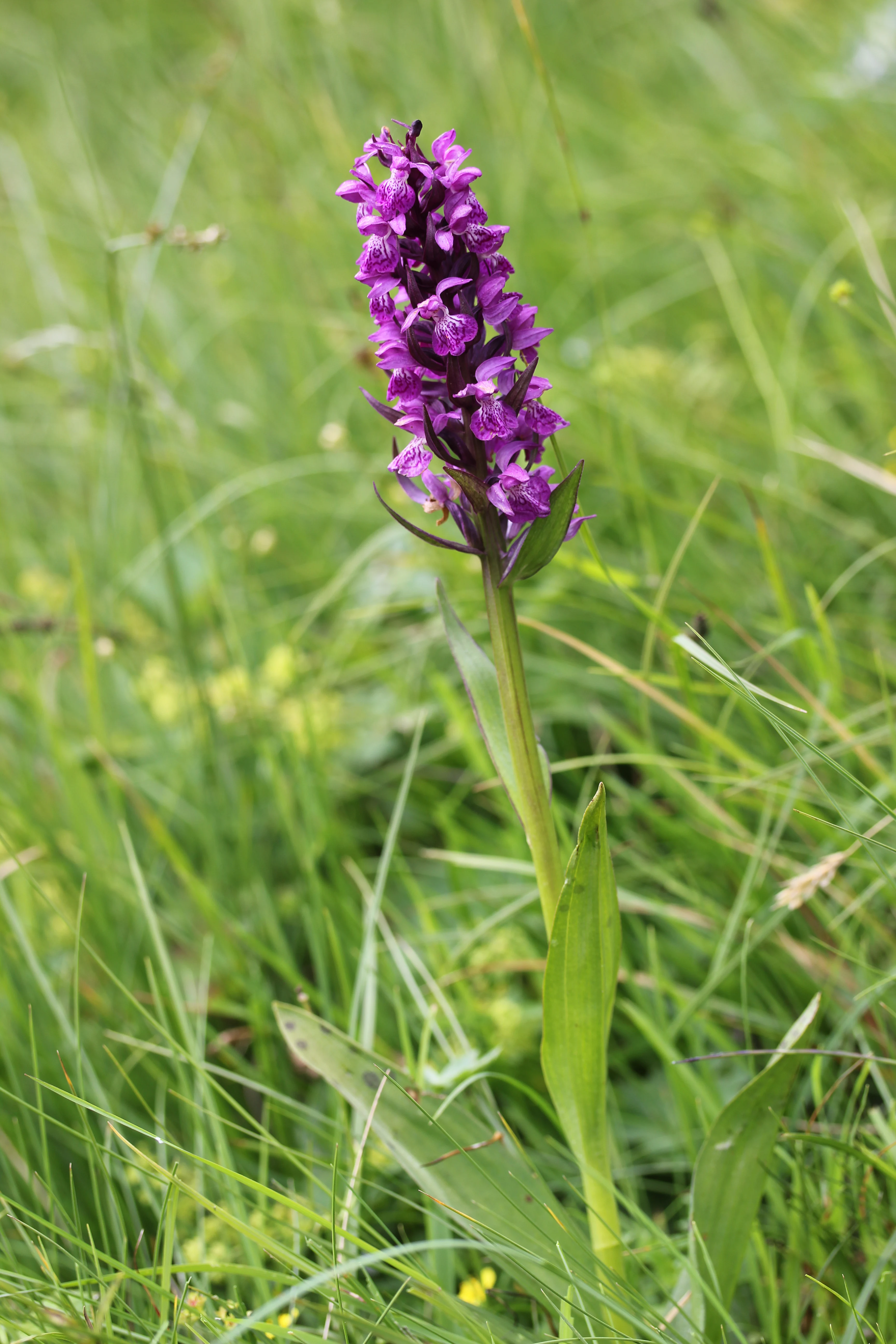
A close up view of a vibrant purple Western Marsh Orchid flowering in a lush green meadow.
A Western Marsh Orchid in the wetland meadow habitat of the Egelpfuhl nature reserve.

Egelpfuhl bei Oberwetz history and protected-area timeline

The area that is now Egelpfuhl bei Oberwetz was placed under formal nature protection on 19 September 1990, when the Hessian authorities designated it as a Naturschutzgebiet under the code 1532024. The designation was issued under the legal framework governing nature protection in Hesse and recognized the valley’s moist meadows and near-natural stream section as habitats of significant ecological value.

Since its protection, the site has also been incorporated into the European bird protection area “Feldflur bei Hüttenberg und Schöffengrund,” reflecting its broader role within the Natura 2000 ecological network. Management has since combined mowing and grazing, with one or two cuts per year across most of the area and cattle grazing in the core zone after a single cut, a regime intended to maintain the open meadow character while limiting scrub encroachment.

Egelpfuhl bei Oberwetz landscape and geographic character

Egelpfuhl bei Oberwetz occupies a modest valley hollow within the rolling agricultural country of central Hesse. Elevations here run from about 283 to 298 meters above sea level, and the terrain gently slopes along the course of the Dreisbach, a small brook that channels westward across the protected site before joining the Wetzbach roughly 600 meters downstream.

The valley character is shaped less by dramatic relief and more by the contrast between the open, low-lying wet meadows in the center and the wooded slopes, fields, and roadways that frame the reserve. To the east, the Landesstraße L 3054 forms a clear boundary; to the north, south, and west, pastures and arable fields press up against the protected area, making the site appear as a vivid green wedge within a working farmed landscape. Riparian vegetation along the stream adds linear texture, with willow and alder thickets softening the transition from open meadow to brook.
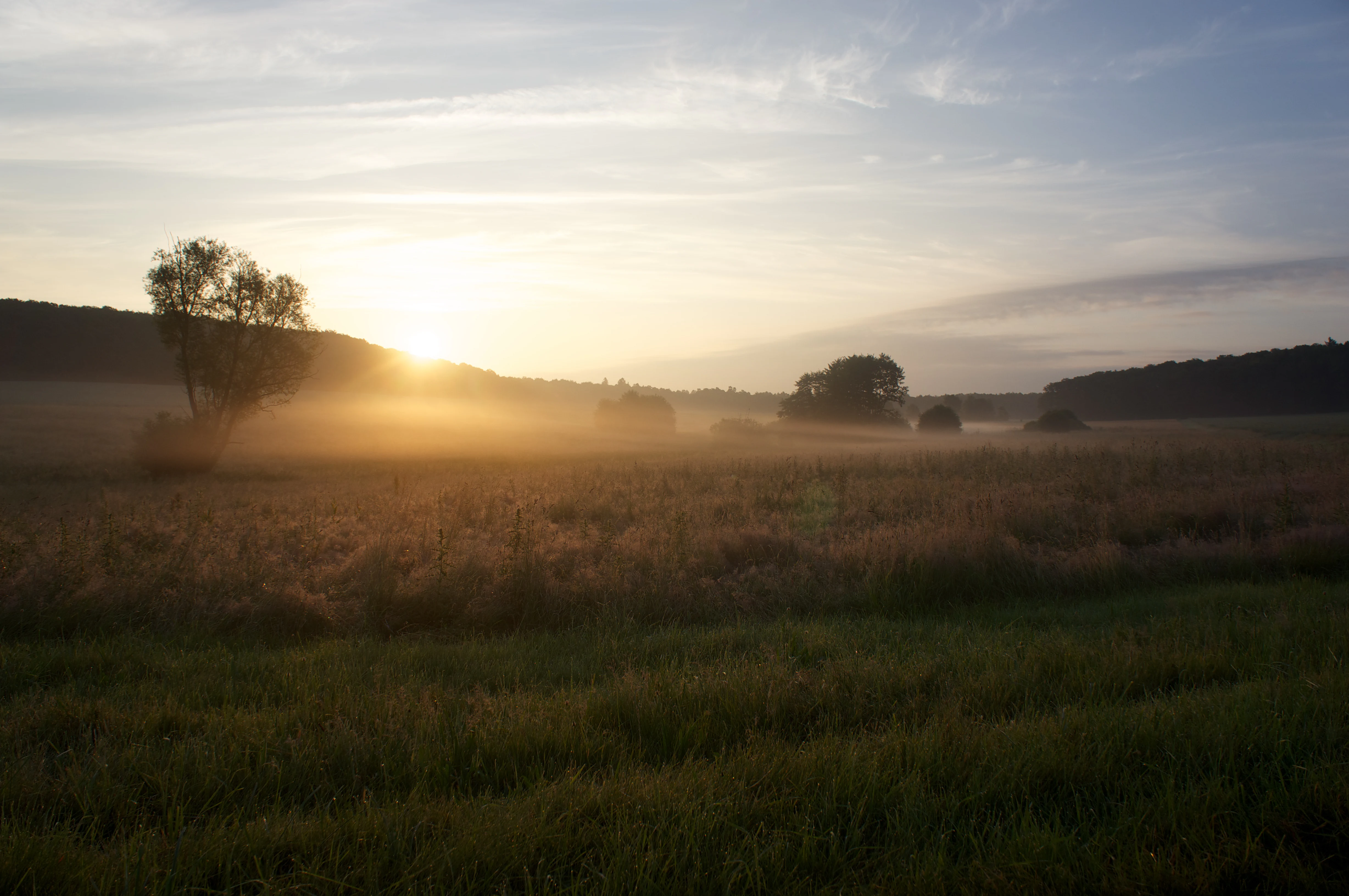
A wide shot of a field at sunrise with a layer of low-lying fog covering the grass and distant trees, illuminated by the rising sun.
Sunrise over the meadow landscape of the Egelpfuhl nature reserve.

Egelpfuhl bei Oberwetz ecosystems, habitats, and plant life

The ecological identity of Egelpfuhl bei Oberwetz rests on its small, tightly knit mosaic of wet meadow habitats. Much of the reserve consists of moist to waterlogged and seasonally saturated soils that support fresh meadows, wet meadows, sedge communities, and reed stands. These open habitats are interrupted by fringes of tall herb vegetation and by willow and alder shrubbery that follows the near-natural course of the Dreisbach.

The plant assemblage reflects the mosaic quality of the site. Documented species include small mousetail (Kleiner Mäuseschwanz), common bogbean (Fieberklee), devil’s-bit scabious (Gewöhnlicher Teufelsabbiss), marsh willowherb (Sumpf-Weidenröschen), narrow-leaved cottongrass (Schmalblättriges Wollgras), the broad-leaved marsh orchid (Breitblättriges Knabenkraut), and the rare bog sedge (Schwarzschopf-Segge). Together these species indicate a functioning, though small, unchanged wet meadow complex that retains the conditions needed by many specialized meadow species.
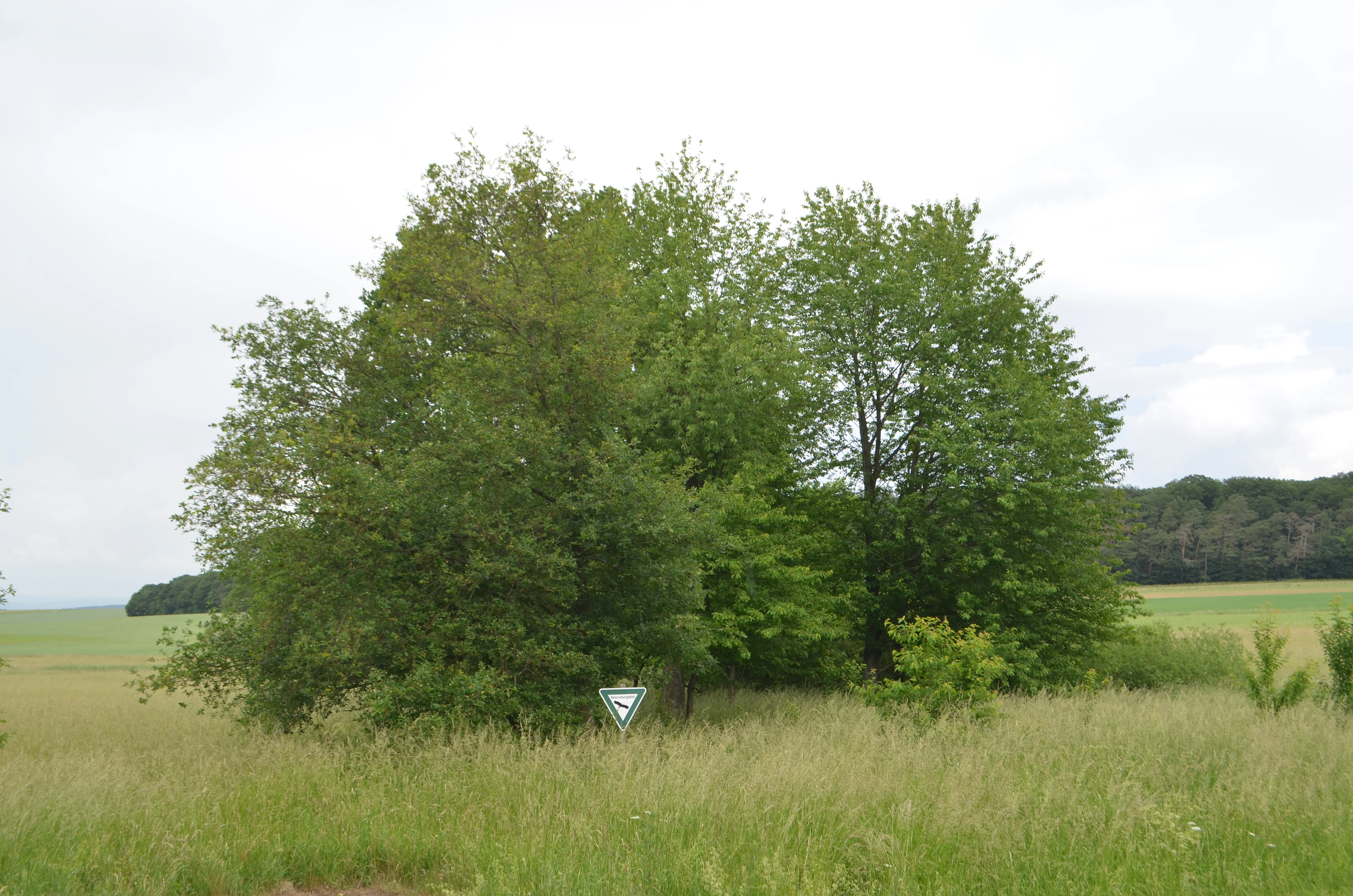
A small group of leafy green trees stands in a grassy field, with a triangular nature reserve sign visible at the base of the trees.
A cluster of trees marking the Egelpfuhl bei Oberwetz nature reserve.

Egelpfuhl bei Oberwetz wildlife and species highlights

The reserve’s compact meadow mosaic supports a notably diverse community of meadow-dependent birds and invertebrates. Among the characteristic bird species recorded here are meadow pipit (Wiesenpieper), common snipe (Bekassine), northern lapwing (Kiebitz), red-backed shrike (Neuntöter), grey partridge (Rebhuhn), red kite (Rotmilan), yellow wagtail (Schafstelze), whinchat (Braunkehlchen), and the strongly threatened European turtle dove (Turteltaube). Several of these species are red-listed in Germany and depend on the open, wet meadow structure that the reserve protects.

The invertebrate fauna is equally significant. The reserve supports populations of the dark large blue butterfly (Dunkler Wiesenknopf-Ameisenbläuling), a strongly endangered species whose life cycle is tied to managed meadows with great burnet (Sanguisorba officinalis). The rare ground beetle Carabus monilis, the feingestreifter Laufkäfer, also occurs here. The presence of these species gives the site a conservation importance well beyond its small spatial footprint.
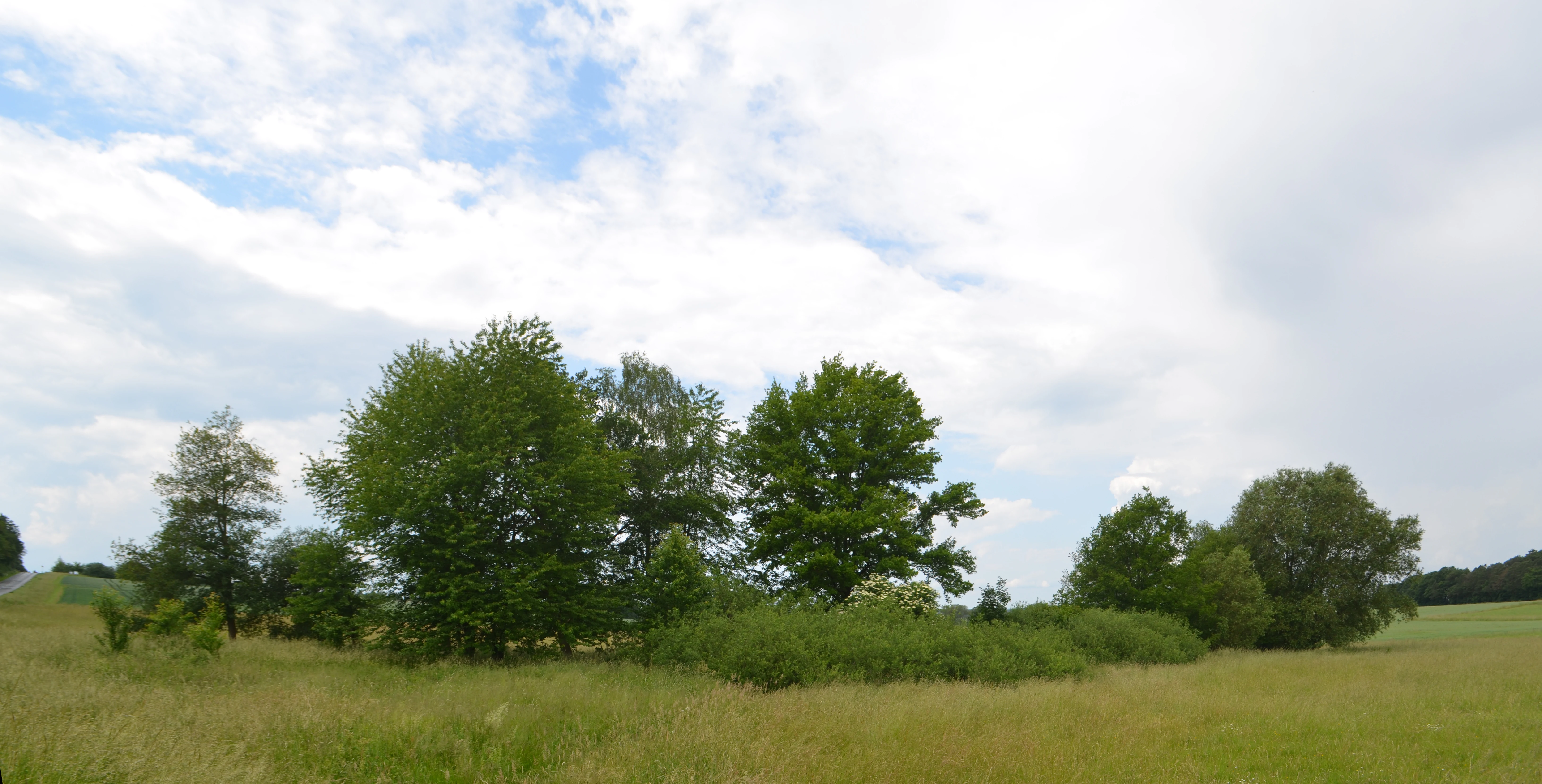
A wide view of a grassy field with a cluster of deciduous trees and shrubs in the center under a cloudy sky.
The damp meadow habitat within the Egelpfuhl bei Oberwetz nature reserve.

Egelpfuhl bei Oberwetz conservation status and protection priorities

Egelpfuhl bei Oberwetz is designated as an IUCN Category IV Habitat/Species Management Area, recognizing its primary conservation objective: the targeted protection of specific habitats and species rather than broad ecosystem preservation. The reserve’s ecological importance is anchored in the combination of an officially designated Hessian Naturschutzgebiet status and its integration into the European bird protection area “Feldflur bei Hüttenberg und Schöffengrund” under the Natura 2000 framework.

Management is deliberately active rather than passive. The conservation regime sets out one to two annual mowing cycles across most of the area, and in the core zone a single cut is followed by grazing with cattle. This combination is designed to maintain the open, species-rich meadow structure, prevent succession toward scrub or woodland, and sustain the specific conditions required by meadow birds, the dark large blue butterfly, and the rare plants of the site. In this way, a very small reserve contributes meaningfully to the persistence of regionally threatened meadow biodiversity.

Top sights and standout views in Egelpfuhl bei Oberwetz

Despite its very small size, Egelpfuhl bei Oberwetz stands out as a densely structured wet meadow refuge within a working agricultural landscape, and as a locally important node within the broader European bird protection area around Hüttenberg and Schöffengrund. Its most distinctive qualities are the tight mosaic of wet meadows, sedges, reeds, tall herb fringes, and willow-alder brookside thickets; the presence of multiple red-listed plant species such as bog sedge, narrow-leaved cottongrass, and broad-leaved marsh orchid; and the occurrence of threatened meadow fauna including the dark large blue butterfly, European turtle dove, and whinchat. Long-term protection through active mowing and grazing regimes reinforces the site’s role as a practical model of small-scale, habitat-focused conservation in central Hesse.

Best time to visit Egelpfuhl bei Oberwetz

The character of Egelpfuhl bei Oberwetz shifts most visibly with the agricultural and ecological rhythm of the meadows rather than with any dramatic seasonal scenery. Late spring and early summer bring the strongest display of flowering meadow plants and orchids, and offer the best opportunity to observe the dark large blue butterfly and other meadow insects in active flight. Early mornings in late spring and summer tend to be the most rewarding period for birdwatching, when meadow birds such as yellow wagtail, whinchat, and northern lapwing are most active over the wet meadows.

Late summer and early autumn can also be appealing, when the meadows take on drier tones after the first cuts and the surrounding agricultural landscape turns golden. Winter visits are quieter and lean toward the structural interest of the bare brookline and the contrast between the protected site and surrounding fields, although wildlife observations are more limited outside the breeding season.

Monthly climate preview

Long-term representative temperature ranges and precipitation metrics for Egelpfuhl bei Oberwetz

Egelpfuhl bei Oberwetz Climate Normals and Monthly Weather Patterns

Representative coordinate records show measured long-term temperature swings from sub-zero winter minimums to warm summer maximums alongside steady daily precipitation rates. Examining the full twelve-month profile reveals complete monthly averages for temperature and moisture variations across this protected area.
Annual mean9 °C
-1 °C19 °C
Jan-1°
Feb
Mar
Apr
May13°
Jun16°
Jul19°
Aug19°
Sep14°
Oct
Nov
Dec
Warmest month
July

18.8 °C

Coolest month
January

-0.6 °C

Wettest month
July

2.5 mm/day

Driest month
April

1.6 mm/day

Park location guide

Geography guide, regional context, and park location map for Egelpfuhl bei Oberwetz

Egelpfuhl bei Oberwetz park geography, regions, and map view in Germany

Understand where Egelpfuhl bei Oberwetz sits in Germany through a broader geographic reading of the surrounding landscape, nearby location context, and its mapped position within the national park landscape.

How Egelpfuhl bei Oberwetz fits into Germany

Germany is a federal republic in Western and Central Europe with a population of over 83 million across sixteen constituent states. It is Europe's largest economy by nominal GDP and a major global exporter and importer. The capital is Berlin, and the country borders Denmark, Poland, Czech Republic, Austria, Switzerland, France, Luxembourg, Belgium, and the Netherlands.

Wider geography shaping Egelpfuhl bei Oberwetz in Germany

Germany is located in Western and Central Europe, spanning 357,022 km². It borders Denmark to the north, Poland and the Czech Republic to the east, Austria and Switzerland to the south, and France, Luxembourg, Belgium, and the Netherlands to the west. The country has coastlines on the Baltic Sea and North Sea to the north, with the Alps located in the southern region.

Map view of Egelpfuhl bei Oberwetz

Use this park location map to pinpoint Egelpfuhl bei Oberwetz in Germany, understand its exact geographic position, and read its mapped placement within the surrounding landscape more clearly.

Pigeon | © OpenStreetMap contributors

Location context for Egelpfuhl bei Oberwetz

Hessen

Visual exploration of wet meadows, valley terrain, and riparian stream habitats

Egelpfuhl bei Oberwetz Photos, Scenery, and Protected Landscape Views

Visual documentation captures the wet meadow mosaic, stream courses, and valley terrain defining Egelpfuhl bei Oberwetz. Photographic records reveal the ecological character and protected habitats preserved within this central German nature reserve.

A close up view of a vibrant purple Western Marsh Orchid flowering in a lush green meadow.

Two Red-backed Shrike birds perched on a green branch against a blurred green background.

A wide shot of a field at sunrise with a layer of low-lying fog covering the grass and distant trees, illuminated by the rising sun.

A small group of leafy green trees stands in a grassy field, with a triangular nature reserve sign visible at the base of the trees.

A wide view of a grassy field with a cluster of deciduous trees and shrubs in the center under a cloudy sky.

An expansive view of a grassy meadow with scattered deciduous trees and a forest line in the background under a cloudy sky.

Park atlas

Compare regional wet meadow reserves and protected landscapes across central Hesse

Explore Other Parks and Protected Areas Near Egelpfuhl bei Oberwetz

Continue browsing alternative nature reserves and protected areas located near Egelpfuhl bei Oberwetz. Comparing neighboring valley habitats provides broader regional context for central German conservation landscapes.
Protected areaGermany
About 15 km away#1 closest

Southeast

Magertriften von Ober-Mörlen und Ostheim Protected Area Geography and Map

A vital nutrient-poor grassland refuge in Hesse, Germany

Located in the Wetteraukreis district, the Magertriften von Ober-Mörlen und Ostheim protected area preserves a rare, species-rich grassland habitat on base-rich soils. This 77-hectare reserve, integrated into the Natura 2000 network, offers a stark contrast between its preserved dry-grassland ecosystems and the surrounding agricultural and industrial transport landscape of central Germany.

Area
0.775 km²
Established
1990
Relief
Lowland
Scope
Terrestrial
A watercolor illustration of a gentle valley landscape with rolling green hills, scattered trees, and a small stream meandering through the center.
Nature reserveHesse
About 17 km away#2 closest

South

Röllbachtal bei Usingen: A Protected Stream Valley and Nature Reserve in Hesse

Mapping riparian restoration and low mountain valley habitats

Röllbachtal bei Usingen represents a key protected landscape in the Eastern Hintertaunus of Germany. The nature reserve manages a narrow stream corridor characterized by alder and ash riparian forests, wet meadows, and tall herb floodplain vegetation. This area provides a clear view into the successful restoration of valley habitats and the broader network of protected natural spaces across the Hochtaunuskreis region.

Area
0.739 km²
Established
1999
Relief
Upland
Climate
Temperate
A wide watercolor illustration showing a purple mountain in the distance, a line of green trees, a body of water, and pinkish plants in the foreground on a white background.
Nature reserveWetteraukreis
About 18 km away#3 closest

Southeast

Breitwiese bei Steinfurth und Oppershofen: A Wetteraukreis Nature Reserve Profile

Examining floodplain ecology and protected wetland boundaries

This protected area in the Wetteraukreis highlights the importance of small-scale floodplain management for biodiversity. The site preserves essential wet meadow habitats, riparian edges, and river-adjacent ecosystems that provide sanctuary for specialized amphibian and bird species. It serves as an informative case study for understanding how conservation grazing and corridor protection interact within an intensive agricultural landscape.

Area
0.164 km²
Established
1990
IUCN
IV
Relief
Lowland
A watercolor painting showing a soft, peaceful landscape with green rolling hills, a small body of water in the foreground, and faint, distant mountains under a pale sky.
Nature reserveHesse
About 19 km away#4 closest

Southeast

Kiesgrube Laukertsberg bei Nieder-Mörlen Protected Area in Hesse, Germany

A reclaimed post-industrial nature reserve and habitat

Located in the Wetterau district of Hesse, Kiesgrube Laukertsberg bei Nieder-Mörlen represents a significant shift from industrial gravel extraction to protected ecological sanctuary. The terrain features open-ground habitats and seasonal wetlands that support sensitive species, illustrating how landscape management can prioritize biodiversity. Analyze the site boundaries and its role within the broader regional geography of central Germany.

Area
0.157 km²
Established
2019
IUCN
IV
Relief
Lowland
A wide watercolor painting showing a green river valley with marshy foreground, a line of trees, and rolling hills in purple and green in the background.
Nature reserveWetteraukreis
About 20 km away#5 closest

Southeast

Salzwiesen von Wisselsheim Nature Reserve: Atlas and Regional Geography of Wetteraukreis

Protected inland salt meadows and floodplain geography in Hesse, Germany.

Salzwiesen von Wisselsheim stands as a significant protected area in the Wetteraukreis region, distinguished by rare inland salt meadows fed by natural saline springs. This reserve presents a compelling landscape defined by the River Wetter, offering deep insights into how unique hydrogeology and historical salt production have formed a specialized lowland habitat that is largely absent from other inland regions.

Area
0.23 km²
Established
1982
Relief
Lowland
Climate
Temperate
Watercolor painting of a rolling landscape with green hills, a small body of water, and clusters of trees under a soft, pale sky.
Nature reserveHessen
About 20 km away#6 closest

Northwest

Koppe Nature Reserve: Protected Basalt Hill and Geological Landmark in Central Hessen

A defined volcanic cone within the forested Hörre ridge range

Koppe stands as a prominent nature reserve in central Hessen, recognized for its unusual conical shape and exposed columnar basalt formations. This protected site integrates geological interest with varied woodland habitats, ranging from dense summit beech forests to open heath communities of pine and juniper. It remains a focal point for understanding the complex natural terrain and protected landscape transitions found throughout the wider Westerwald-Lahn-Taunus region.

Area
0.234 km²
Established
1931
Relief
Mountain
Climate
Temperate
A soft watercolor painting depicting a gentle landscape with rolling hills, meadows, and sparse vegetation, rendered in muted pastel tones.
Nature reserveHessen
About 22 km away#7 closest

North

Brühl von Erda Nature Reserve: Geographic Overview and Mapped Protected Landscapes

A diverse habitat mosaic in the Hessen region

Located in central Hessen, the Brühl von Erda nature reserve comprises 33 hectares of complex terrain including spring hollows, wet meadows, and dry grassland swards. This protected area acts as a focal point for regional conservation, preserving a transition zone between waterlogged fens and drier, thin-soil slopes within the Lahn-Dill-Kreis district.

Area
0.337 km²
Established
1979
IUCN
IV
Relief
Lowland
A watercolor painting of a rolling landscape featuring open fields in the foreground, distant hills, and a cluster of pine and deciduous trees on the right side.
Nature reserveHochtaunuskreis
About 22 km away#8 closest

Southwest

Riedelbacher Heide Nature Reserve: Geographic Map and Landscape Analysis of the Taunus

A preserved open heathland within the forested Hintertaunus uplands

Riedelbacher Heide offers a focused look at an 8.4 hectare nature reserve located on the high plateau of the eastern Hintertaunus. This area provides valuable insight into the ecological and cultural history of the Taunus, where historical grazing practices shaped a distinctive mosaic of open, sun-exposed vegetation. The reserve serves as a critical example of traditional land management in a predominantly forested low-mountain geography.

Area
0.084 km²
Established
1969

Common questions about visiting, size, designation, and location context for Egelpfuhl bei Oberwetz

Egelpfuhl bei Oberwetz FAQs for park facts, access, geography, and protected area context

Find quick answers about Egelpfuhl bei Oberwetz, including protected-area facts, park geography, trail and visitor context, and how the park fits into its surrounding country and regional landscape.
MoriAtlas Explorer

Continue Your Protected Areas Search Across the Global Atlas

Deepen your exploration by continuing the structured search for national parks and protected areas worldwide. Utilize the comprehensive filtering capabilities to compare different conservation landscapes and refine your understanding of global park geography. Discover more about the distribution and characteristics of protected natural areas.

Global natural geography