
Mori Atlas logo
Nature reserveEichelskopf

Tracing the mapped boundaries and historical conservation context of the Schwalm-Eder district.

Eichelskopf Nature Reserve: Examining the Oldest Protected Geological Landscape in Hesse

Eichelskopf stands as a significant protected landmark in the Schwalm-Eder district of Hesse, Germany. Designated in 1927, this compact nature reserve offers a unique look into regional geological heritage and early conservation efforts. This analysis provides a deep look at the reserve's spatial footprint and its foundational role within the broader framework of German protected areas.

nature reserveNaturschutzgebietHesseSchwalm-Edergeological heritagehistorical heritage
A digital illustration showing a vertical waterfall plunging over light colored rock cliffs into a pool surrounded by dense forest, viewed through the branches of foreground trees.

Eichelskopf

Nature reserve

Park overview

Structured park overview, official facts, and landscape profile for Eichelskopf

Eichelskopf park facts, protected area profile, and essential visitor context

Review the core facts for Eichelskopf, including designation, size, terrain, visitor scale, habitats, and operating context in one park-focused overview.

About Eichelskopf

Eichelskopf is a protected nature reserve located in the Gemarkung (cadastral area) of Holzhausen, which belongs to the town of Homberg (Efze) in the Schwalm-Eder district of central Hesse, Germany. The reserve covers just 2.68 hectares of land, making it the smallest Naturschutzgebiet in the Schwalm-Eder district yet also one of the longest-standing protected sites in the region.

The area was first formally designated as a nature reserve on 20 August 1927, through an official announcement in the gazette of the Regierung zu Kassel (the regional government in Kassel). At the time of its initial designation, the primary motivations were geological and historical in nature rather than ecological, indicating that the site's significance was understood early on in terms of landscape heritage and earth science rather than modern wildlife conservation.

Four decades later, the reserve's purpose was broadened. On 12 June 1967, a new ordinance was published in the Staatsanzeiger des Landes Hessen that re-designated the area under the same name but with a more detailed set of prohibitions, explicitly incorporating species protection (Artenschutz) into the reserve's mandate. This shifted Eichelskopf from a primarily geological and historical protection model to one that also formally safeguards the plant and animal communities found on the site.

Administrative responsibility for Eichelskopf lies with the Obere Naturschutzbehörde, the Upper Nature Protection Authority based at the Regierungspräsidium Kassel. Day-to-day care and management of the site is delegated locally to the Forstamt Neukirchen, the forestry office responsible for the surrounding area. Visitors to the reserve are expected to observe the detailed prohibitions set out in the 1967 ordinance in order to ensure the continued protection of flora and fauna.

Protection and recognition

Documented terrestrial designation history and official conservation scope

Eichelskopf Protection Status and International Recognition Data

Eichelskopf maintains a documented terrestrial protection status established in 1967 without recorded transboundary designations. Official records outline the historical designation framework and international recognition scope governing the protected landscape.

Protection details

Protection scope
Terrestrial
Designated year
1967
Transboundary protection
No
Park context

Deeper park guide and search-rich context for Eichelskopf

Eichelskopf history, landscape, wildlife, and travel context

Explore Eichelskopf through its history, landscape character, ecosystems, wildlife, conservation priorities, cultural context, and seasonal travel timing in a structured park guide built for atlas discovery and search intent.

Why Eichelskopf stands out

Eichelskopf is best known for being simultaneously the smallest nature reserve and the oldest nature reserve in the Schwalm-Eder district, with origins that predate most modern conservation frameworks in Hesse.
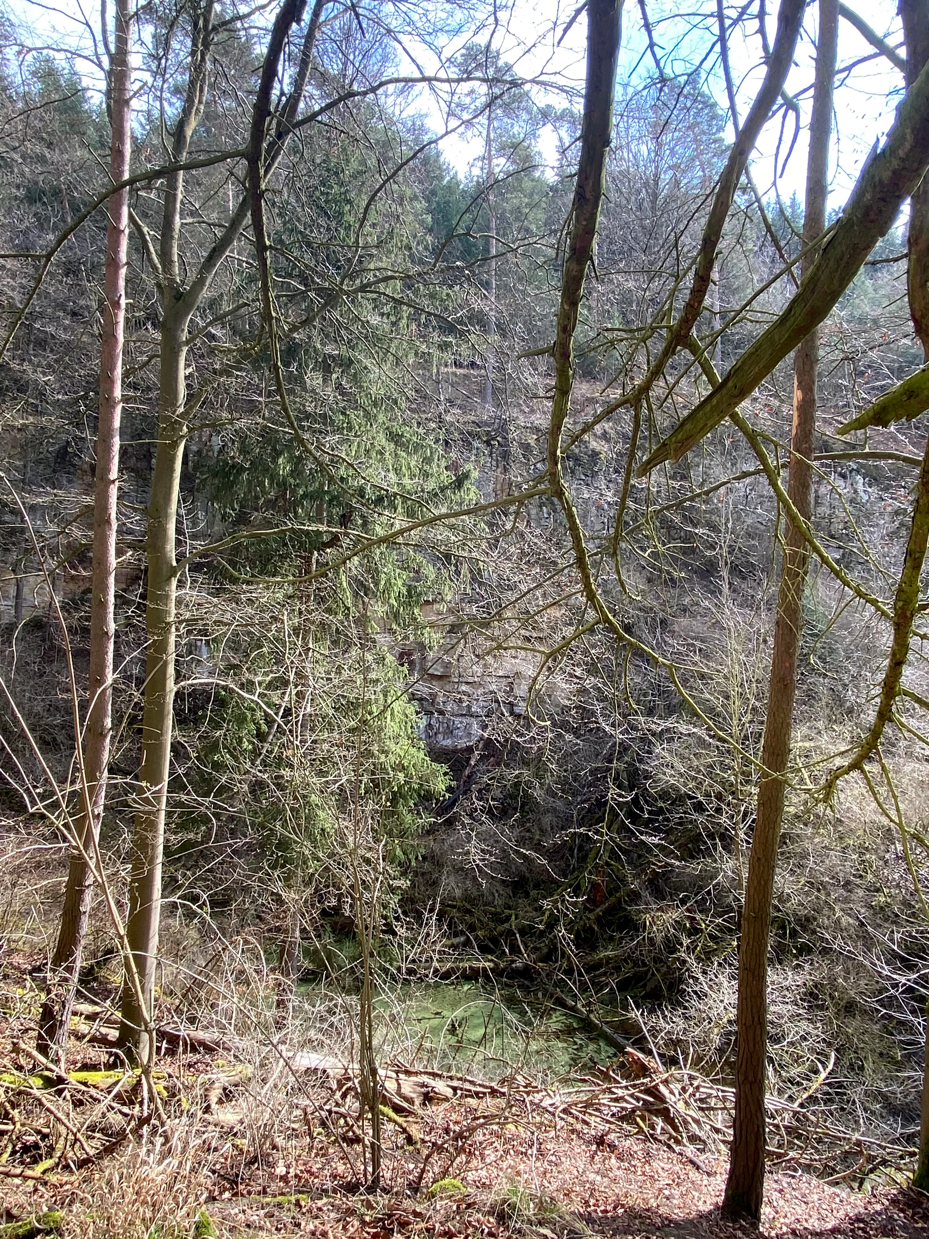
A slightly obscured view looking through bare tree branches and tree trunks at a forest slope and a small pool of water at the bottom of a hollow.
A view into the wooded terrain of Eichelskopf nature reserve in Germany.

Eichelskopf history and protected-area timeline

Eichelskopf holds a special place in the conservation history of the Schwalm-Eder district because it is the oldest of all the nature reserves still recognized there. Its initial designation came on 20 August 1927, when it was formally declared a Naturschutzgebiet through a public notice issued in the Amtsblatt der Regierung zu Kassel, the official gazette of the Kassel regional government. The motivations recorded for this early action were primarily geological and historical, suggesting that the reserve was valued at that time for the character of its landforms and its cultural-historical context rather than for ecological reasons.

The reserve's legal framework was significantly updated forty years later. On 12 June 1967, a new ordinance concerning the Eichelskopf nature reserve was published in the Staatsanzeiger des Landes Hessen, the state gazette of Hesse. This ordinance re-designated the same site under the same name but introduced more detailed and explicit prohibitions governing activity within the reserve. Importantly, the 1967 re-designation marked the addition of species protection (Artenschutz) to the reserve's purpose, broadening its mandate to include the direct safeguarding of the area's plants and animals alongside its previously recognized geological and historical values.

Since 1967, administrative responsibility for the reserve has rested with the Obere Naturschutzbehörde (Upper Nature Protection Authority) of the Regierungspräsidium Kassel. Local stewardship on behalf of this authority is carried out by the Forstamt Neukirchen, the regional forestry office, which manages day-to-day oversight of the protected site.

Eichelskopf conservation status and protection priorities

Eichelskopf's conservation profile is shaped by two distinct phases of protection. Its original 1927 designation recognized the site principally for its geological and historical significance, an early example of landscape-based conservation in what is now the Schwalm-Eder district of Hesse.

The 1967 ordinance fundamentally expanded the reserve's conservation mandate by adding species protection (Artenschutz) and introducing a more detailed set of activity prohibitions. These rules are intended to safeguard both the plants and animals of the site and remain binding on anyone visiting the area.

As a Naturschutzgebiet under Hessian state law, Eichelskopf falls under the supervision of the Obere Naturschutzbehörde at the Regierungspräsidium Kassel, with practical management carried out by the Forstamt Neukirchen. Despite its very small size of 2.68 hectares, the reserve functions as an enduring example of long-term, multi-objective nature protection in central Hesse.

Monthly climate preview

Long-term representative coordinate measurements tracking multi-month temperature and precipitation patterns in Hesse

Eichelskopf Climate Normals: Annual Temperature and Monthly Precipitation Rhythms

Historical climate records for Eichelskopf track measured monthly temperature swings from sub-zero winter minimums to warm summer maximums alongside steady year-round precipitation. Reviewing the complete twelve-month profile provides deeper analytical insight into long-term environmental patterns across the regional terrain.
Annual mean9 °C
-1 °C19 °C
Jan-1°
Feb
Mar
Apr
May12°
Jun16°
Jul19°
Aug18°
Sep14°
Oct
Nov
Dec
Warmest month
July

18.6 °C

Coolest month
January

-0.8 °C

Wettest month
July

2.5 mm/day

Driest month
April

1.4 mm/day

Park location guide

Geography guide, regional context, and park location map for Eichelskopf

Eichelskopf park geography, regions, and map view in Germany

Understand where Eichelskopf sits in Germany through a broader geographic reading of the surrounding landscape, nearby location context, and its mapped position within the national park landscape.

How Eichelskopf fits into Germany

Germany is a federal republic in Western and Central Europe with a population of over 83 million across sixteen constituent states. It is Europe's largest economy by nominal GDP and a major global exporter and importer. The capital is Berlin, and the country borders Denmark, Poland, Czech Republic, Austria, Switzerland, France, Luxembourg, Belgium, and the Netherlands.

Wider geography shaping Eichelskopf in Germany

Germany is located in Western and Central Europe, spanning 357,022 km². It borders Denmark to the north, Poland and the Czech Republic to the east, Austria and Switzerland to the south, and France, Luxembourg, Belgium, and the Netherlands to the west. The country has coastlines on the Baltic Sea and North Sea to the north, with the Alps located in the southern region.

Map view of Eichelskopf

Use this park location map to pinpoint Eichelskopf in Germany, understand its exact geographic position, and read its mapped placement within the surrounding landscape more clearly.

Pigeon | © OpenStreetMap contributors

Location context for Eichelskopf

Hesse

Explore detailed photography of terrain, geological heritage features, and protected habitats across Eichelskopf.

Eichelskopf Photos and Protected Landscape Scenery: Visualizing the Oldest Nature Reserve in Hesse

Visual documentation captures the unique topography, geological heritage landforms, and protected habitats defining Eichelskopf. Detailed photography provides a clear perspective on the oldest nature reserve in the Schwalm-Eder district.

A slightly obscured view looking through bare tree branches and tree trunks at a forest slope and a small pool of water at the bottom of a hollow.

Park atlas

Compare surrounding regional reserves and connected natural landscapes

Explore Other Parks and Protected Areas Near Eichelskopf

Browse nearby nature reserves and regional protected areas to see how surrounding landscapes compare to Eichelskopf. Extending the geographic review helps place small historic reserves into a wider regional conservation context.
A wide watercolor illustration showing a pale sky above a line of green trees and a foreground of pink and green grassy meadows.
Nature reserveSchwalm-Eder-Kreis
About 3.7 km away#1 closest

Northwest

Mosenberg bei Homberg Nature Reserve: Mapped Protected Landscape and Regional Geography

Nature reserve terrain in the Schwalm-Eder-Kreis district of northern Hesse

Spanning 64 hectares, Mosenberg bei Homberg preserves a diverse mixture of traditional agricultural landscapes including open grasslands and wood-pastures. The area provides a critical habitat for specialized birds, defined by its steep basalt scree and proximity to the Klingelbach stream. This site offers a clear example of how historic coppice woodland systems maintain significant biodiversity across the northern Hesse region.

Area
0.646 km²
Established
1986
Relief
Upland
Climate
Temperate
A horizontal watercolor painting depicting a soft-toned, rolling landscape with green meadows, distant tree lines, and a light-filled sky.
Nature reserveHesse
About 5.1 km away#2 closest

Southeast

Roßbachtal bei Völkershain Nature Reserve: Geography and Protected Valley Landscapes

Stream-fed meadow and forest habitats in Hesse

Located in the Schwalm-Eder-Kreis, Roßbachtal bei Völkershain encompasses a linear valley environment within the Knüllgebirge. The reserve tracks the Roßbach stream as it moves toward the Breitenbach, featuring a protected alignment of meadows and slopes that serves as a focused habitat management area in central Germany.

Area
1.141 km²
Established
1988
IUCN
IV
A horizontal watercolor painting of a serene lake bordered by a shoreline with trees and distant rolling hills against a soft background.
Nature reserveSchwalm-Eder-Kreis
About 5.6 km away#3 closest

North

Goldbergsee Nature Reserve and Mapped Protected Landscapes in Schwalm-Eder-Kreis

Ecological transition and inland water-body geography.

Goldbergsee stands as a prime case study of industrial renaturalization in northern Hesse. This protected nature reserve, characterized by its clear spring-fed water and successional woodland habitat, offers a window into how former open-cast mining sites evolve into ecologically balanced water bodies within the Schwalm-Eder-Kreis mountain foothills.

Established
1991
A watercolor painting showing a tranquil lake shore with soft green vegetation and distant muted hills.
Nature reserveSchwalm-Eder-Kreis
About 11 km away#4 closest

West

Borkener See Nature Reserve: Geographic Overview of a Reclaimed Wetland and Bird Sanctuary

A protected landscape featuring oligotrophic lake waters in Schwalm-Eder-Kreis.

Borkener See serves as a focal point for understanding the reclamation of mining landscapes in northern Germany. As an officially protected nature reserve, it provides a stable habitat for migratory bird species, with deep water basins and carefully managed wetland buffers defining its physical and ecological presence in the Westhessische Senke.

Area
3.5 km²
Established
1990
Relief
Lowland
Climate
Temperate
A watercolor painting showing a wide, panoramic view of soft, rolling hills with patches of forest, rendered in muted pastel colors.
Protected landscapeHesse
About 12 km away#5 closest

South

Naturpark Knüll: Geography, Basalt Formations, and Protected Areas of Northern Hesse

An expansive cultural landscape defined by volcanic ridges and riverine habitats

Naturpark Knüll offers a deep look into the geological and structural diversity of the Knüllgebirge. By mapping the transitions between bunter sandstone, basalt hilltops, and fertile floodplains, this resource highlights the region's role in biodiversity conservation and sustainable land management across the Schwalm-Eder and Hersfeld-Rotenburg districts.

Area
832.58 km²
Established
2021
Relief
Mountain
Climate
Temperate
A soft, panoramic watercolor painting depicting a green floodplain with a winding river, scattered trees, and rolling hills in the distance.
Nature reserveSchwalm-Eder-Kreis
About 13 km away#6 closest

East

Fuldatal bei Konnefeld: Protected Floodplain and Wetland Geography in Schwalm-Eder-Kreis

An essential river valley habitat and nature reserve in northern Hesse

Fuldatal bei Konnefeld is a compact, high-value nature reserve situated along the Fulda river valley. The landscape is defined by its old river oxbows, soft-wood forest galleries, and species-rich hay meadows. This resource provides a focused geographic overview of its protected status as a Natura 2000 site and its function as a vital wildlife corridor.

Area
0.169 km²
Established
1989
IUCN
IV
Relief
Lowland
A watercolor illustration showing a winding river flowing through a grassy field, with a cluster of green trees on the right and soft pink and gray hills in the background.
Nature reserveGermany
About 15 km away#7 closest

East

Kiesgrube bei Baumbach Nature Reserve: River Meander and Wetland Geography in Germany

A preserved riparian landscape and bird habitat in northern Hesse

Located along the middle Fulda, this nature reserve represents an engineered success story where a former quarry transformed into a vital wetland ecosystem. Its shallow lake margins, willow thickets, and floodplain forests create a critical protected area for local waterbird populations, serving as an essential node within the Auenverbund Fulda floodplain conservation network.

Area
0.23 km²
Established
1995
Relief
Lowland
Climate
Temperate
Watercolor illustration of a dirt path leading through green fields towards a distant line of trees and rolling hills against a white background.
Nature reserveHesse
About 18 km away#8 closest

South

Buchenbachtal bei Christerode Nature Reserve: Protected Landscape and Regional Geography

Mapped stream corridors and wet meadow ecosystems in Hesse

Located in central-western Germany, Buchenbachtal bei Christerode focuses on the conservation of small low-mountain streams and broadleaf forest transition zones. This nature reserve provides a essential look at riparian habitat management and the traditional agricultural integration that shapes the natural terrain of the northern Hessian region.

Area
120.5 km²
Established
1995
Water
Major water bodies

Common questions about visiting, size, designation, and location context for Eichelskopf

Eichelskopf FAQs for park facts, access, geography, and protected area context

Find quick answers about Eichelskopf, including protected-area facts, park geography, trail and visitor context, and how the park fits into its surrounding country and regional landscape.
MoriAtlas Explorer

Continue Your Protected Areas Search Across the Global Atlas

Deepen your exploration by continuing the structured search for national parks and protected areas worldwide. Utilize the comprehensive filtering capabilities to compare different conservation landscapes and refine your understanding of global park geography. Discover more about the distribution and characteristics of protected natural areas.

Global natural geography