
Mori Atlas logo
Nature reserveEldrup Skov og søer og moser i Løvenholm Skov

Tracing the mapped boundaries of this unique forest and wetland landscape on the Djursland peninsula

Eldrup Skov og søer og moser i Løvenholm Skov: A Protected Nature Reserve in Region Midtjylland

(Natura 2000-område nr. 47 Eldrup Skov og søer og moser i Løvenholm Skov)

Eldrup Skov og søer og moser i Løvenholm Skov serves as a vital Natura 2000 protected area spanning 155 hectares across the Djursland peninsula. The site features a complex mosaic of old growth beech forest, active raised bogs, and rare brown water lakes that offer a distinct look at the glacial geography of central Jutland. This protected landscape provides a window into the remnant wetland systems of Region Midtjylland, illustrating the interplay between dry sandy ridges and waterlogged peat basins.

bograised bogbrown-water lakebeech forestheathNatura 2000
A vector-style digital illustration of a serene forest landscape featuring a waterfall cascading into a lake, with birch trees in the foreground, coniferous trees, and a pale sunset sky.

Eldrup Skov og søer og moser i Løvenholm Skov

Nature reserve

Park overview

Structured park overview, official facts, and landscape profile for Eldrup Skov og søer og moser i Løvenholm Skov

Eldrup Skov og søer og moser i Løvenholm Skov park facts, protected area profile, and essential visitor context

Review the core facts for Eldrup Skov og søer og moser i Løvenholm Skov, including designation, size, terrain, visitor scale, habitats, and operating context in one park-focused overview.

About Eldrup Skov og søer og moser i Løvenholm Skov

Eldrup Skov og søer og moser i Løvenholm Skov is a compact yet richly layered Natura 2000 protected area positioned within the broader woodland landscape of central Djursland. Although it comprises only 155 hectares, the site is functionally a collection of five separate parcels that together capture a cross-section of the natural character of inland Djutland: forested ridges, kettle lakes, open bogs, and heath remnants.

Roughly three quarters of the entire area is forested, dominated by the broadleaf cover of Eldrup Skov in the southwest and parts of the larger Løvenholm Skov to the east. Eldrup Skov contributes entirely forest habitat, while the Løvenholm Langsø sub-area centers on a single, ecologically distinctive brown-water lake. The final three sub-areas, Gjesing Mose, Sømose, and Kragmose, weave forested fringes around open, light-flooded bog habitat, producing a mosaic that is rare on this scale in Denmark.

A defining feature of the site is its connection to a once-uninterrupted raised-bog landscape that spread across Djursland between Fuglsø Mose in the east and Pindstrup Mose in the west. Today only isolated fragments of that ancient bog system survive within the Natura 2000 boundary, and the area's conservation targets are explicitly oriented around preserving and expanding those remnants where natural conditions allow.

Quick facts and research context for Eldrup Skov og søer og moser i Løvenholm Skov

The site is located in Region Midtjylland within Norddjurs Kommune, on the central Djursland peninsula of eastern Jutland. It is officially registered as Natura 2000 area no. 47 and EU habitat area H43, combining five distinct sub-areas across the Eldrup and Løvenholm forests.

Totaling 155 hectares, the area is composed mainly of broadleaf forest, with substantial open bog, heath, lake, and stream habitats completing the mosaic. The Natura 2000 plan covering the site was originally adopted in 2011 and is coordinated locally with the Djursland water plan.

Protection and recognition

Documented terrestrial protection scope and Natura 2000 recognition

Eldrup Skov og søer og moser i Løvenholm Skov Protection Status

Eldrup Skov og søer og moser i Løvenholm Skov maintains a documented terrestrial protection scope supported by official Natura 2000 recognition records. Visitors and researchers can review structured conservation designations and management boundaries for this protected area.
Park context

Deeper park guide and search-rich context for Eldrup Skov og søer og moser i Løvenholm Skov

Eldrup Skov og søer og moser i Løvenholm Skov history, landscape, wildlife, and travel context

Explore Eldrup Skov og søer og moser i Løvenholm Skov through its history, landscape character, ecosystems, wildlife, conservation priorities, cultural context, and seasonal travel timing in a structured park guide built for atlas discovery and search intent.

Why Eldrup Skov og søer og moser i Løvenholm Skov stands out

The site is best known for bringing together rare and ecologically delicate habitat types in a small footprint: brown-water dystrophic lake, dry heath, active raised bog, degraded raised bog, bog woodland, and beech-on-podzol with holly forest. It also stands out for protecting fragments of what was once a vast Djursland raised-bog complex that extended between Fuglsø Mose in the east and Pindstrup Mose in the west. Today, surviving raised-bog and birch-swamp remnants anchor the conservation identity of the three core bog sub-areas: Gjesing Mose, Sømose, and Kragmose.
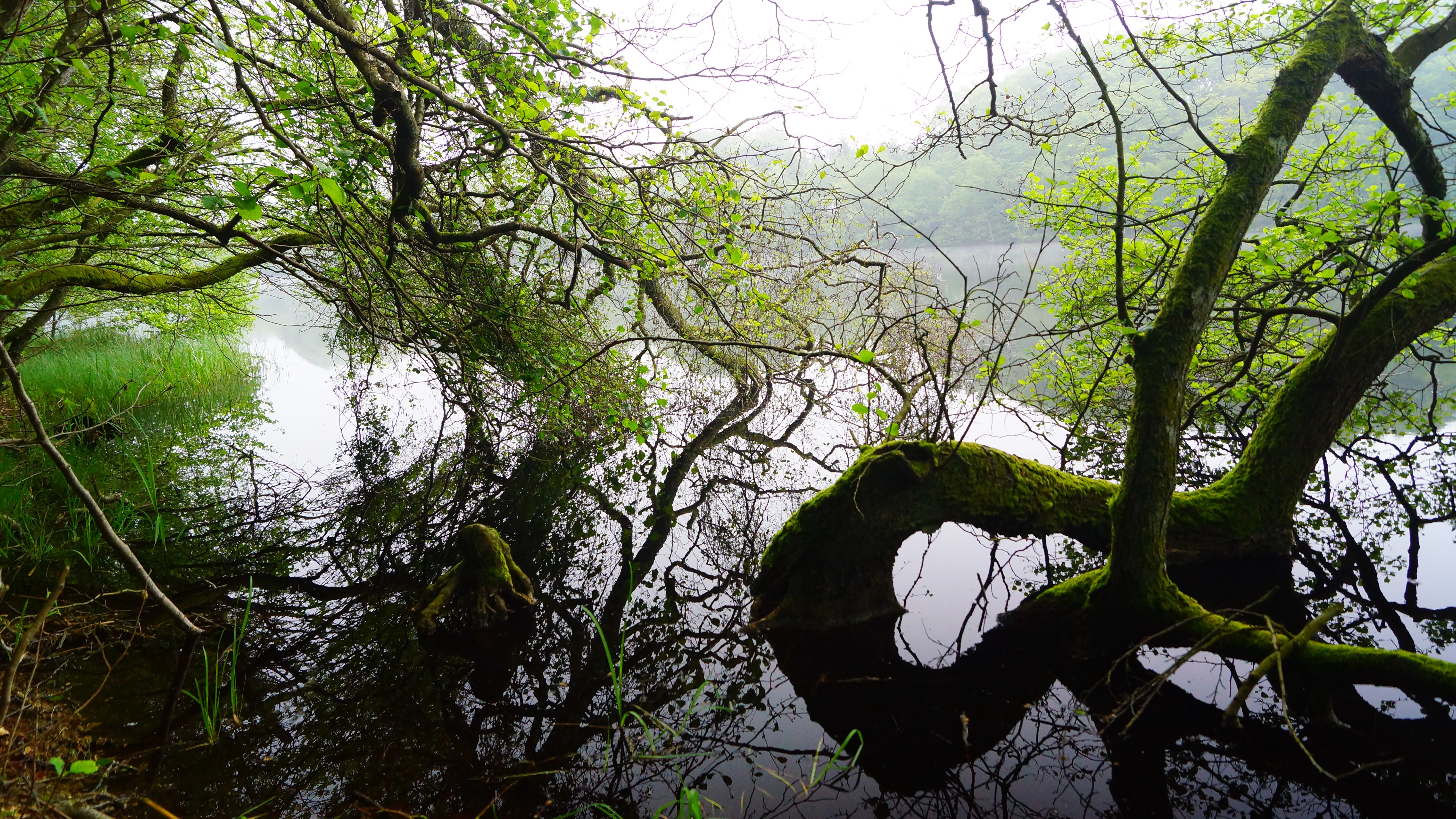
Tree branches draped with moss reach over the still surface of Langsø lake, creating reflections in the water.
A serene view of Langsø lake surrounded by the lush forest of Eldrup Skov.

Eldrup Skov og søer og moser i Løvenholm Skov history and protected-area timeline

The area's nature-protection history begins with its recognition as part of the Danish Natura 2000 network under the EU Habitats Directive, where it is registered both as Natura 2000 area no. 47 and as EU habitat area H43. The site draws together forest, bog, heath, and lake habitat types that reflect older ecological conditions across central Djursland, including fragments of a substantial raised-bog landscape that once connected sites much further east and west along the peninsula.

Formal Natura 2000 planning for the site was adopted in 2011, after which the local municipal council in Norddjurs Kommune and the Danish Nature Agency (Naturstyrelsen) developed binding action plans to implement the plan's conservation targets. The plan was designed to be renewed and refined across successive plan periods so that habitat-condition goals could be reassessed over time.

The site is also coordinated with the regional water plan known as Vandplan 1.6 Djursland, reflecting how its lake, stream, and bog habitats are intertwined with broader hydrological management in the area.

Eldrup Skov og søer og moser i Løvenholm Skov landscape and geographic character

The physical setting of the Natura 2000 site is shaped by the glacial and post-glacial landscape typical of inland Djursland, with gently undulating terrain that alternates between dry, sandy-podzol ridges and waterlogged low-lying basins. Forest dominates the higher ground, while the lowest-lying basins hold peat-forming wetlands and oligotrophic lakes.

Løvenholm Langsø is a particular landscape highlight: a brown-water, nutrient-poor lake type that is rare in Denmark and visually distinctive because of its dark, tannin-stained surface. Surrounding the lake and threading between the parcels is a network of forest edges and small forest tracks that connect the open habitats with the surrounding woodland.

The three bog sub-areas, Gjesing Mose, Sømose, and Kragmose, share a common landscape signature of open peat surfaces bordered by birch swamp and gradually transitioning into dry heath at the margins. Together these features give the protected area a clearly layered physical structure: forest uplands, transitional heath edges, and wetland cores.
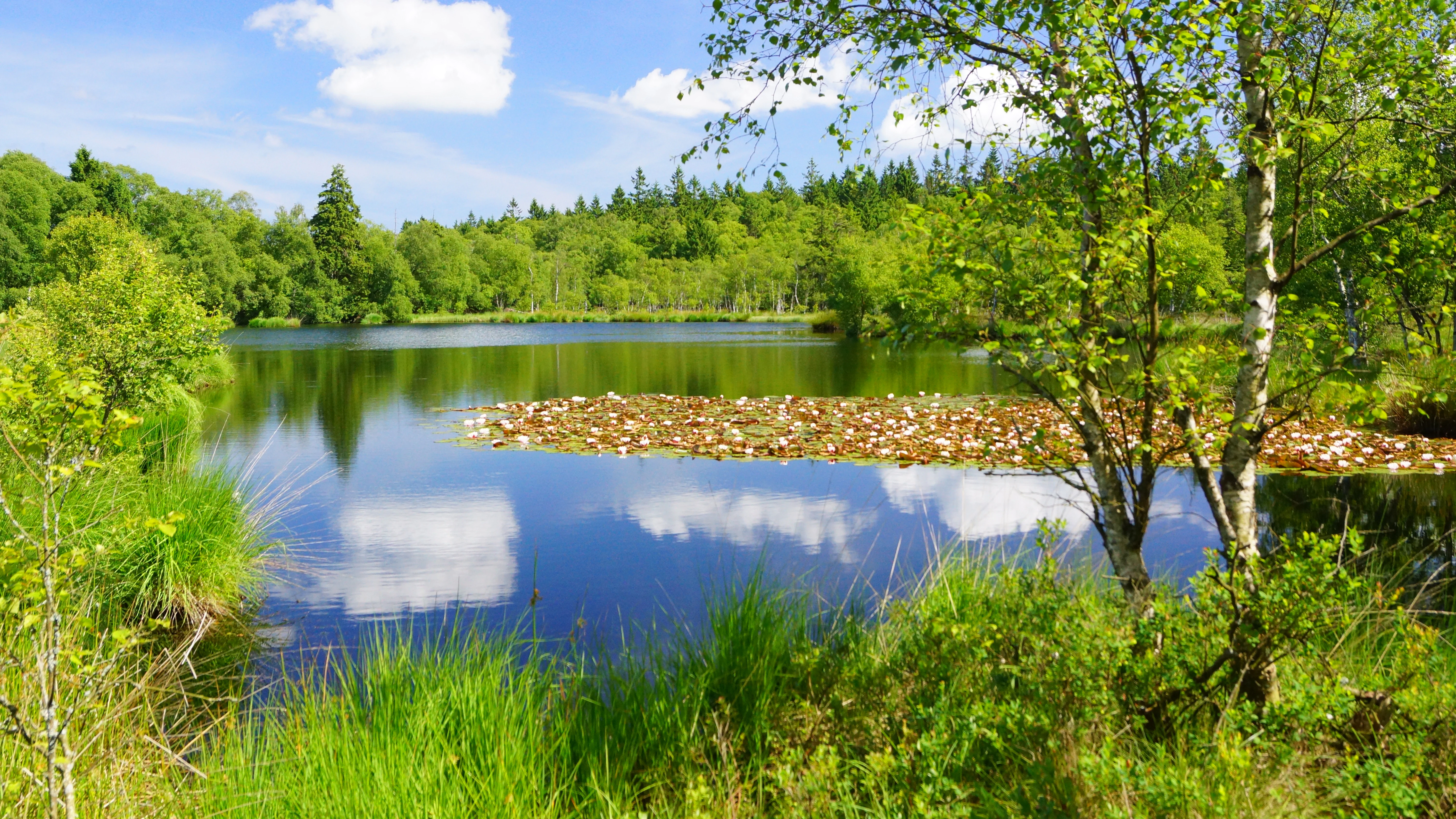
A calm, reflective lake in a peat bog with lily pads on the surface, surrounded by lush green forest and birch trees under a blue sky.
A peaceful peat bog lake surrounded by dense forest in Løvenholm Skov.

Eldrup Skov og søer og moser i Løvenholm Skov ecosystems, habitats, and plant life

Ecologically, the site is remarkable for squeezing several high-value habitat types into a relatively small area. Active raised bog, degraded raised bog, and bog woodland sit alongside dry heath, brown-water dystrophic lake, and a particularly unusual beech-on-podzol forest that also includes holly.

These habitat types reflect a long ecological gradient from dry nutrient-poor mineral soils through increasingly waterlogged peat substrates, and the close proximity of those habitats is part of what makes the site valuable for conservation. About 48 percent of the area is additionally protected under the Danish Nature Protection Act's Section 3, covering roughly 40 hectares of lakes and ponds, 16 hectares of heath, 19 hectares of bog, and around 0.8 kilometers of stream.

The overall vegetation pattern combines the closed-canopy character of beech forest, the sparse moss-and-shrub structure of degraded raised bog, and the grassy dryness of inland heath, producing a layered habitat mosaic that is uncommon in Denmark at this scale.

Eldrup Skov og søer og moser i Løvenholm Skov wildlife and species highlights

While the area is primarily valued for its habitat types rather than its species lists, the combination of habitats supports a range of typical central-Danish woodland and wetland fauna. The extensive broadleaf forest, particularly the beech-on-podzol with holly stands, provides habitat for forest interior and edge species connected to the wider Eldrup and Løvenholm forest complexes.

The open bogs, heath, and Løvenholm Langsø brown-water lake together provide wetland and aquatic habitat more broadly connected to the wetland networks of Djursland, supporting species assemblages associated with bog pools, dystrophic lakes, and dry heath.

Both forest and open habitat are managed in ways that aim to maintain naturalness, which in practice supports a regional rather than nationally exceptional species profile while strengthening habitat continuity with surrounding woodland and bog landscapes.

Eldrup Skov og søer og moser i Løvenholm Skov conservation status and protection priorities

The site's principal conservation significance lies in acting as one of the few surviving refuges within what was once a far larger raised-bog landscape across Djursland. By protecting fragments of active and degraded raised bog alongside bog woodland, the Natura 2000 designation safeguards the remaining peat-forming processes and associated biodiversity of that historic landscape.

Conservation management prioritizes maintaining and, where natural conditions permit, expanding the area's high-quality raised-bog habitats, even when this requires sacrificing some other habitat features in the process. Eldrup Skov is conserved as natural forest (naturskov), while Løvenholm Langsø is managed toward a favorable conservation status as a brown-water dystrophic lake.

About half the area, roughly 75 hectares, enjoys additional Danish Section 3 protection, ensuring layered national and EU-level safeguards. The binding action plans adopted in 2011 by Norddjurs Kommune and Naturstyrelsen continue to structure habitat management, and the site is coordinated with water planning for the Djursland region to keep hydrological conditions supportive of bog and lake conservation.

Eldrup Skov og søer og moser i Løvenholm Skov cultural meaning and human context

The protected area is closely tied to the broader identity of the Løvenholm and Eldrup forests, which together form a substantial continuous broadleaf woodland on Djursland. While the source material provides limited direct description of indigenous or traditional land-use context, the site's forest character reflects the historical role of managed broadleaf woodlands in the inland Danish landscape.

Local place names such as Gjesing Mose, Sømose, and Kragmose, and references to former peat-cutting activity, point to a long human relationship with the bog systems for traditional uses like turf-cutting before ecological conservation goals took precedence.

Top sights and standout views in Eldrup Skov og søer og moser i Løvenholm Skov

Five ecologically distinct sub-areas joined into one Natura 2000 unit; roughly 75 percent forest cover combined with rare open bog and heath; a nationally scarce brown-water dystrophic lake at Løvenholm Langsø; surviving remanants of a once-massive Djursland raised-bog landscape; and a combination of EU and Danish national protection layers, including comprehensive Section 3 coverage.

Best time to visit Eldrup Skov og søer og moser i Løvenholm Skov

Because the site's main attractions are quiet landscape and habitat features rather than seasonal wildlife spectacles, spring and early summer tend to highlight the contrast between fresh forest foliage, flowering heath, and the dark, tannin-tinted surface of Løvenholm Langsø. Late summer and autumn bring warmer-toned broadleaf forest colors and visible peat surfaces in the open bogs, while winter offers the clearest views across the open wetlands and an unobstructed sense of the bog-and-heath mosaic.


Monthly climate preview

Long-term monthly temperature and precipitation rhythm for Eldrup Skov og søer og moser i Løvenholm Skov

Eldrup Skov og søer og moser i Løvenholm Skov Climate Normals and Temperature Patterns

Representative coordinate records show measured multi-year temperature ranges and precipitation rates across twelve distinct monthly intervals for Eldrup Skov og søer og moser i Løvenholm Skov. Detailed monthly climate normals and comprehensive precipitation data reveal the complete annual atmospheric cycle for this protected area.
Annual mean9 °C
1 °C17 °C
Jan
Feb
Mar
Apr
May11°
Jun15°
Jul17°
Aug17°
Sep14°
Oct10°
Nov
Dec
Warmest month
August

17.1 °C

Coolest month
February

1.2 °C

Wettest month
October

2.7 mm/day

Driest month
April

1.5 mm/day

Park location guide

Geography guide, regional context, and park location map for Eldrup Skov og søer og moser i Løvenholm Skov

Eldrup Skov og søer og moser i Løvenholm Skov park geography, regions, and map view in Denmark

Understand where Eldrup Skov og søer og moser i Løvenholm Skov sits in Denmark through a broader geographic reading of the surrounding landscape, nearby location context, and its mapped position within the national park landscape.

How Eldrup Skov og søer og moser i Løvenholm Skov fits into Denmark

Denmark is a constitutional monarchy and Nordic country in Northern Europe. It is the southernmost of the Scandinavian countries, bordering Germany to the south, Norway to the north, and Sweden to the southwest. The country consists of the Jutland peninsula and an archipelago of islands, with Copenhagen as its capital and largest city. Denmark has a population of over 6 million and is characterized by flat, arable land, sandy coasts, and a temperate climate.

Wider geography shaping Eldrup Skov og søer og moser i Løvenholm Skov in Denmark

Denmark occupies the Jutland peninsula and roughly 406 islands in Northern Europe. It is situated between the North Sea to the west and the Baltic Sea to the east. The country borders Germany to the south and is connected to Sweden via the Øresund Bridge. Denmark is predominantly flat terrain with low elevation, the highest point being Møllehøj at 170.86 meters.

Map view of Eldrup Skov og søer og moser i Løvenholm Skov

Use this park location map to pinpoint Eldrup Skov og søer og moser i Løvenholm Skov in Denmark, understand its exact geographic position, and read its mapped placement within the surrounding landscape more clearly.

Pigeon | © OpenStreetMap contributors

Location context for Eldrup Skov og søer og moser i Løvenholm Skov

Region Midtjylland
Recorded earthquake history

Review Recorded Earthquake History for Eldrup Skov og søer og moser i Løvenholm Skov

Gain insight into the seismic history of the region by browsing documented events associated with the Eldrup Skov protected area. This MoriAtlas catalogue provides a structured view of historical records, including magnitudes and proximity data for the local forest landscape.

Eldrup Skov Earthquake History

Catalogued events

1 event

Strongest magnitude

Magnitude 3.2

Most recent event

May 30, 1995

This history includes earthquakes recorded inside the park or within 50 km of its borders

Visualizing the protected habitats, old-growth beech forests, and wetland mosaic of central Jutland

Eldrup Skov og søer og moser i Løvenholm Skov Photos and Landscape Scenery

Visual records capture the undulating terrain, dark tannin-stained waters, and open peat bogs defining Eldrup Skov og søer og moser i Løvenholm Skov. Photographic documentation reveals the ecological layout of forest uplands, transitional heath edges, and rare wetland habitats across the protected area.

Tree branches draped with moss reach over the still surface of Langsø lake, creating reflections in the water.

A dirt path with two tire tracks runs through a deep green forest. Sunlight filters through the dense trees, illuminating bright green undergrowth on the left and along the trail.

A calm, reflective lake in a peat bog with lily pads on the surface, surrounded by lush green forest and birch trees under a blue sky.

Park atlas

Compare nearby forest complexes and wetland reserves across the Djursland peninsula region

Parks Near Eldrup Skov og søer og moser i Løvenholm Skov and Surrounding Protected Landscapes

Continue exploring regional protected areas and adjacent forest reserves after reviewing Eldrup Skov og søer og moser i Løvenholm Skov. Comparing surrounding terrain provides broader context on local woodland habitats and wetland preservation.
Watercolor illustration showing rolling hills, a lake, pink flowering trees, and distant mountains
National parkDenmark
14 km away#1 closest

South

Mols Bjerge National Park: Glacial Geography and Protected Terrain in Central Jutland

Mapping the coastal cliffs and rolling heathland of Denmark

Mols Bjerge National Park protects a sweeping mosaic of glacial hills, woodlands, and coastal zones on the Djursland peninsula. With a landscape shaped by ancient ice sheets, the park offers a detailed view into Denmark's geological history, preserved ancient barrows, and rich botanical diversity along the Kattegat sea.

Area
180 km²
Established
2009
IUCN
II
Relief
Upland
Protected landscapeRanders Kommune
About 16 km away#2 closest

Northwest

Naturpark Randers Fjord: Estuarine Geography and Protected Coastal Landscape in Denmark

Regional landscape profile and wetland ecosystem mapping

Naturpark Randers Fjord preserves a notable concentration of diverse ecosystems, from the unique east-facing tidal flats at Udbyhøj to the inland mosaic of bogs and dry grasslands. This protected area offers insight into the complex water-based topography where the Gudenå river meets the fjord. Explore the geographic composition, mapped boundaries, and varied terrain that define this protected landscape in the Randers Kommune area.

Area
292.5 km²
Established
2018
Relief
Lowland
Climate
Temperate
A stylized digital illustration of a valley featuring a cascading waterfall between two mountains, with a winding river in the foreground and pine trees.
Protected areaDenmark
About 16 km away#3 closest

West

Randers Fjord Protected Area: Mapping the Reed-Dominated Estuaries of Eastern Denmark

Coastal river mouth geography and tidal wetland terrain

Randers Fjord represents a significant protected area in eastern Jutland, Denmark, characterized by its winding water corridor and tall stands of common reed. This geographic survey details the transition from the Gudenå river channel to the Kattegat, highlighting the marsh-like atmosphere and conservation-focused wetlands that define the regional coastline.

Established
2018
Relief
Lowland
Climate
Temperate
Access
Easy access
Watercolor painting of a panoramic landscape featuring green rolling hills, light foliage, and patches of pink wildflowers in the foreground.
National parkCentral Jutland
About 22 km away#4 closest

South

Nationalpark Mols Bjerge: A Geographic Overview of Central Jutland's Glacial Landscape

Mapped terrain, dead-ice hills, and prehistoric monuments

Nationalpark Mols Bjerge offers a deep look into the glacial heritage of Central Jutland. The area features steep, sun-exposed slopes, heathland, and coastal fringes that provide a unique perspective on the Danish landscape. By examining the park's mapped boundaries, one can identify the convergence of geological landforms and ancient cultural history preserved within this protected environment.

Relief
Mountain
Access
Easy access
Water
Major water bodies
Nature reserveRegion Midtjylland
23 km away#5 closest

Southeast

Stubbe Sø Nature Reserve: A Geographic Exploration of Djursland Protected Landscapes

Mapping the wetlands, forest fringes, and mire systems of eastern Jutland.

Stubbe Sø is a central protected feature within the landscape of eastern Jutland, comprising a large shallow lake surrounded by alder-birch shorelines and coniferous plantations. This nature reserve offers deep insight into the glaciated terrain and wetland mosaic of the Djursland peninsula, providing an essential geographic reference for understanding local conservation habitats and regional waterbird migration corridors.

Area
7.78 km²
Established
1963
Relief
Lowland
Climate
Temperate
Nature reserveRegion Midtjylland
26 km away#6 closest

South

Tved Kær Nature Reserve: Protected Coastal Habitat Geography in Region Midtjylland

Exploring lime-rich fens and coastal cliff terrain.

Tved Kær represents a compact but ecologically dense protected area in Denmark, known for its rare calcareous fen and seepage vegetation. Situated near the village of Tved, this nature reserve integrates coastal cliffs and raised seabed to form a distinct habitat mosaic within the Mols peninsula, serving as a vital site for rare orchid species and lime-rich soil preservation.

Area
0.06 km²
Established
1981
Relief
Lowland
Climate
Temperate
Watercolor painting of a calm coastal bay with soft, layered green hills in the distance and a pale shoreline in the foreground.
Protected areaDenmark
About 32 km away#7 closest

South

Begtrup Vig Protected Area: Glacial Terrain and Coastal Geography in Denmark

Coastal landscape and regional protected area mapping

Begtrup Vig is a distinct coastal bay defined by its glacial history, stretching across the southern Djursland peninsula in Denmark. Within the broader Mols Bjerge national park framework, the area features varied topography including stony shores, sandy coves, and pastoral meadows. This record provides a focused look at the environmental boundaries and geographic significance of this protected habitat, bridging natural terrain with the regional landscape context.

Relief
Upland
Scope
Mixed
Water
Water-dominated
Season
Year-round
A horizontal watercolor illustration showing a calm coastal bay with grassy banks, winding water channels, and rolling hills in the background under a soft yellow sky.
Protected areaRegion Midtjylland
About 32 km away#8 closest

South

Natura 2000-område nr. 51 Begtrup Vig og kystområder ved Helgenæs Geography and Maps

Coastal grasslands and marine habitats in Region Midtjylland

Examine the complex terrain of Natura 2000-område nr. 51 Begtrup Vig og kystområder ved Helgenæs, an expansive protected area characterized by its diverse coastal cliff systems and large calcareous grasslands. This site documents the evolution of the Kattegat shoreline through its unique recurved spits and lifted seabed formations, providing a window into the natural landscape history of the Helgenæs peninsula.

Area
17.71 km²
Established
2011
Relief
Lowland
Climate
Temperate

Common questions about visiting, size, designation, and location context for Eldrup Skov og søer og moser i Løvenholm Skov

Eldrup Skov og søer og moser i Løvenholm Skov FAQs for park facts, access, geography, and protected area context

Find quick answers about Eldrup Skov og søer og moser i Løvenholm Skov, including protected-area facts, park geography, trail and visitor context, and how the park fits into its surrounding country and regional landscape.
MoriAtlas Explorer

Continue Your Protected Areas Search Across the Global Atlas

Deepen your exploration by continuing the structured search for national parks and protected areas worldwide. Utilize the comprehensive filtering capabilities to compare different conservation landscapes and refine your understanding of global park geography. Discover more about the distribution and characteristics of protected natural areas.

Global natural geography