
Mori Atlas logo
State or regional parkEnglishman River Falls Provincial Park

Analyzing the coastal forest, river canyon terrain, and natural cascades of this British Columbia regional park.

Englishman River Falls Provincial Park: A Mapped Protected Landscape on Vancouver Island

Englishman River Falls Provincial Park is a protected landscape on Vancouver Island, defined by the two-tiered river cascades and a deep canyon carved into the coastal lowlands. The geography features mature stands of Douglas fir, western red cedar, and hemlock, creating a distinct rainforest environment surrounding the Englishman River. This park territory serves as a vital natural corridor, providing significant topographical variety from its rocky riverbeds and mossy ledges to the forested slopes of the Pacific Northwest.

Vancouver IslandBritish Columbiawaterfallold-growth forestDouglas fir forestcoastal rainforest
A stylized, flat-design illustration of a waterfall tumbling over rocky cliffs into a pool, surrounded by pine forests and distant hills.

Englishman River Falls Provincial Park

State or regional park

Park overview

Structured park overview, official facts, and landscape profile for Englishman River Falls Provincial Park

Englishman River Falls Provincial Park park facts, protected area profile, and essential visitor context

Review the core facts for Englishman River Falls Provincial Park, including designation, size, terrain, visitor scale, habitats, and operating context in one park-focused overview.

About Englishman River Falls Provincial Park

Englishman River Falls Provincial Park is a small but visually dramatic protected area on the east-central coast of Vancouver Island. It sits west of Parksville, bordering the community of Errington, and is part of the network of parks and reserves managed by BC Parks across British Columbia. Although it covers only about 97 hectares, the park concentrates its natural character around a single striking feature: the falls of the Englishman River, which drop in two main steps through a forested canyon.

The landscape of the park is shaped by the river itself. Short, well-used trails descend from the parking and day-use areas toward both the upper and lower falls, with footbridges crossing the gorge where necessary. At the base of the lower falls, the river has carved out a deep pool that is popular with visitors during summer, and the surrounding cliffs create a small but memorable swimming and cliff-jumping area. The atmosphere is one of concentrated coastal rainforest scenery packed into a compact footprint, with mossy boulders, drifting spray, and tall conifers framing the water.

Beyond the falls, the park protects stands of mature forest that include both old-growth Douglas fir, cedar, hemlock, and maple as well as regenerated second-growth patches. These forests support the cool, shaded microclimate that defines the trail experience and contribute to the park's ecological value as a refuge for typical Vancouver Island coastal vegetation. Although the park is small, its accessibility from Parksville, its campground facilities, and the presence of nearby regional parks along the same river system make it a significant recreation node on the island. The name of the park and the river themselves carry First Nations oral tradition, with a local legend placing the skeleton of a white man near the falls, a story that has become part of the place's cultural identity.

Quick facts and research context for Englishman River Falls Provincial Park

Englishman River Falls Provincial Park lies on Vancouver Island in British Columbia, Canada, near the communities of Parksville and Errington. It is a BC Parks-managed provincial park classified as an IUCN Category II protected area, equivalent to a national park designation in terms of conservation intent. The park is centered on the twin waterfalls of the Englishman River and protects about 97 hectares of Douglas fir, cedar, hemlock, and maple forest, much of it old growth.

The park functions as both a day-use recreation area and a small campground destination, with bridge-linked trails connecting the upper and lower falls, a swimming and cliff-jumping area, and seasonal salmon runs visible from the riverbanks. Its setting beside other protected green spaces along the same river reinforces its role as part of a network of accessible natural areas on the island.

Protection and recognition

Documented terrestrial protection scope and international recognition records

Englishman River Falls Provincial Park Protection Status and Management Scope

Terrestrial protection status and management parameters define the conservation framework governing Englishman River Falls Provincial Park. Documented recognition records outline official designation history across established administrative boundaries.

Protection details

Protection scope
Terrestrial
Transboundary protection
No
Park context

Deeper park guide and search-rich context for Englishman River Falls Provincial Park

Englishman River Falls Provincial Park history, landscape, wildlife, and travel context

Explore Englishman River Falls Provincial Park through its history, landscape character, ecosystems, wildlife, conservation priorities, cultural context, and seasonal travel timing in a structured park guide built for atlas discovery and search intent.

Why Englishman River Falls Provincial Park stands out

The park is best known for its pair of cascading waterfalls on the Englishman River, framed by old-growth coastal forest just minutes from Parksville. The lower falls have become something of a local landmark because of the deep, cold swimming hole at their base, which historically has attracted cliff jumpers despite the chilly temperatures and rocky setting. The combination of easily reachable waterfalls, short interpretive trails, and a swim-friendly canyon is the central identity of the park. It is also recognized for its mature stands of Douglas fir, cedar, hemlock, and maple, which give the short trails a distinctly west-coast rainforest atmosphere. Seasonal salmon spawning in the Englishman River adds a layer of natural interest, drawing visitors who come specifically to watch the fish move upstream through the falls area.
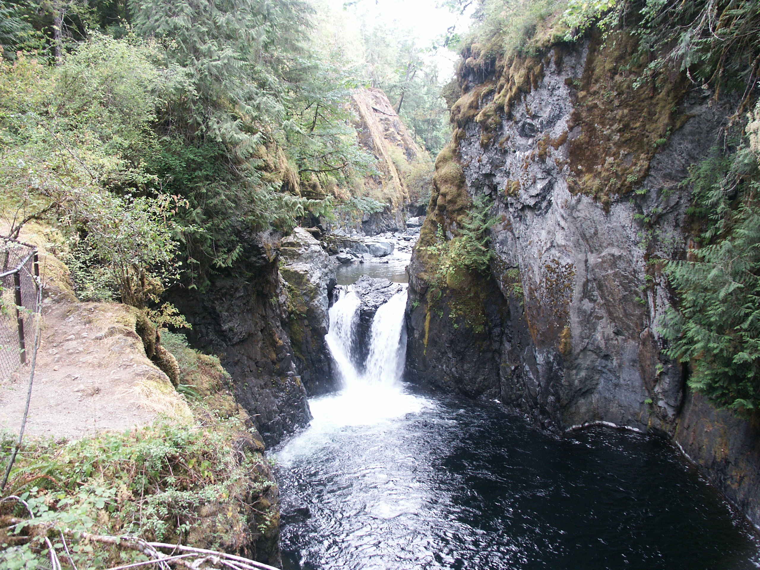
A view of a waterfall flowing through a narrow, mossy rock canyon, surrounded by dense forest foliage, with a hiking trail railing visible on the left.
The Englishman River cascades into a narrow, rocky canyon within Englishman River Falls Provincial Park.

Englishman River Falls Provincial Park history and protected-area timeline

The Englishman River, and by extension the park, carries a name drawn from First Nations oral tradition. According to legend referenced in the park's history, early Indigenous accounts described the discovery of a lone white man's skeleton near the falls, and this story became attached to the river and the site long before the area received formal protected status.

In its modern form, the park was established as a BC Parks-administered provincial park to preserve the waterfalls, the surrounding old-growth forest, and the recreational value of the river corridor. It is currently classified as an IUCN Category II protected area, reflecting management intent comparable to a national park in terms of conservation emphasis. Trail improvements have continued incrementally, including a 2019 community-partnered effort to expand and reroute pathways within the park, indicating an ongoing relationship between BC Parks and local volunteers in shaping visitor access around the falls.

Englishman River Falls Provincial Park landscape and geographic character

The landscape of Englishman River Falls Provincial Park is dominated by a narrow river canyon carved by the Englishman River through coastal British Columbia forest. The river descends in two main steps, producing the upper and lower falls that define the park's geography. Below the lower falls, erosion has sculpted a deep plunge pool and steep rock walls that form a small, dramatic amphitheatre of cliffs, boulders, and mossy ledges.

Above and around the canyon, the terrain is shaped by the typical hummocky ground of the Vancouver Island coastal lowlands. Slopes rise gently away from the river, blanketed in tall conifers and broadleaf trees whose roots grip rocky, moisture-rich soil. Footbridges span the gorge at strategic points, allowing trails to follow the rim and descend into the canyon without requiring visitors to negotiate the steepest rock directly. The result is a compact landscape in which waterfalls, forest, and canyon cliffs all sit within a very short walking distance of one another.

Englishman River Falls Provincial Park ecosystems, habitats, and plant life

Ecologically, the park sits within the coastal western hemlock and Douglas fir biogeoclimatic zone that characterizes much of eastern Vancouver Island. Its 97 hectares protect a combination of old-growth and second-growth forest dominated by Douglas fir, western red cedar, western hemlock, and bigleaf maple, with the older trees giving the trail corridors a shaded, cathedral-like character. Fallen logs, mossy trunks, and damp undergrowth reflect the high-rainfall climate of the region and the way the forest constantly recycles itself along the river corridor.

The Englishman River itself is a defining ecological thread through the park. Its cool, oxygen-rich water supports salmon that return seasonally to spawn, and the riparian zone along the banks adds structural diversity to the surrounding forest. The combination of canyon microclimate, perpetual spray from the falls, and dense canopy cover produces a humid environment that supports the characteristic mosses, ferns, and shade-tolerant plant communities of the Pacific Northwest coast.

Englishman River Falls Provincial Park wildlife and species highlights

Wildlife in Englishman River Falls Provincial Park is closely linked to the river and the old coastal forest that surrounds it. The most conspicuous and seasonally significant wildlife presence is the salmon that spawn in the Englishman River, which can be observed in season moving upstream through the falls area. The sight of fish gathering at the base of the cascades is one of the park's recurring natural events, and it draws visitors specifically interested in the life cycle of Pacific salmon species.

The mature Douglas fir, cedar, hemlock, and maple stands provide habitat typical of Vancouver Island's coastal forests, including perching and nesting opportunities for a range of resident and migratory birds. Small mammals, amphibians, and invertebrates occupy the damp understory, mossy logs, and shaded stream margins. While the park is small and heavily visited, the continuity of forest cover along the river corridor, including links to adjacent regional parks, helps support wildlife movement through the broader Englishman River watershed.

Englishman River Falls Provincial Park conservation status and protection priorities

From a conservation perspective, Englishman River Falls Provincial Park matters less for its size than for what it concentrates within that footprint. The park protects a representative example of low-elevation Vancouver Island coastal forest, including old-growth Douglas fir, cedar, hemlock, and maple stands that have become increasingly rare on the island as historic logging has removed many of the largest trees elsewhere. Even a relatively small protected forest block like this contributes to maintaining habitat continuity, microclimatic stability, and water quality along the Englishman River.

Its IUCN Category II designation indicates that the area is managed primarily for ecosystem protection, placing it in the same broad conservation tier as national parks. Combined with the adjacent Englishman River Regional Park and a nearby municipal park along the same river, the provincial park forms an important node in a connected system of protected green space on east-central Vancouver Island, helping to buffer the watershed from surrounding land uses and preserving the ecological character of the falls and the forest that surrounds them.

Englishman River Falls Provincial Park cultural meaning and human context

The name Englishman River, and therefore the name of the park itself, carries an Indigenous oral tradition. A First Nations legend associated with the falls tells of the discovery of the skeleton of a white man near the river, and this story was remembered and retold until it became the commonly accepted explanation for how the river got its English name. The legend connects the place to long-standing Indigenous knowledge of the landscape, even as the formal name preserves a non-Indigenous reference.

In contemporary terms, the park is also part of the everyday recreational culture of mid-Vancouver Island. It functions as a local swimming spot, a family-friendly hiking destination, and a seasonal anchor for residents of Parksville and Errington who use it for day trips and overnight camping. The continued involvement of community groups in trail development, including the 2019 partnership work, reflects an ongoing local relationship with the site that extends beyond simple visitation.

Top sights and standout views in Englishman River Falls Provincial Park

The strongest highlights of Englishman River Falls Provincial Park are highly concentrated. The upper and lower Englishman River Falls are the centerpiece, accessed by short, year-round hiking trails and footbridges that make the canyon reachable for nearly all visitors. The deep swimming hole at the base of the lower falls is one of the most recognizable features of the park, particularly in warmer months, even though it requires care because of the cliff-jumping height and cold water.

Equally important is the surrounding forest, which preserves old-growth and second-growth Douglas fir, cedar, hemlock, and maple close to the falls. Seasonal salmon runs in the Englishman River add a living, recurring natural event that elevates an already attractive landscape. Together with the 107-site campground and a large day-use area, these features make the park a compact but unusually rich recreation and nature site on eastern Vancouver Island.

Best time to visit Englishman River Falls Provincial Park

The park is accessible year round, and its character shifts noticeably between seasons. Summer is the most popular and busiest period, when warm weather draws visitors to the swimming hole at the base of the lower falls and the campground is in full use; this is also when park trails and bridges are most heavily travelled. Late summer into autumn generally corresponds with salmon returning to spawn in the Englishman River, which adds a focused wildlife interest for visitors willing to watch the river closely.

Shoulder seasons and winter bring quieter trails and a different atmosphere, with higher rainfall feeding the falls and reinforcing the lush, mossy rainforest feel of the forest. Cooler temperatures make the swimming hole less appealing, but the waterfalls typically run with more volume and the surrounding Douglas fir, cedar, hemlock, and maple forest feels particularly atmospheric in the soft, wet weather that defines the region.
Monthly climate preview

Long-term temperature and precipitation averages measured across the representative park coordinate

Englishman River Falls Provincial Park Climate Normals and Weather by Month

Historical climate records for Englishman River Falls Provincial Park show a measured annual cycle of shifting monthly temperatures and precipitation rates from twelve-year baseline data. Reviewing the complete twelve-month temperature profile reveals the full scope of long-term weather patterns recorded at this British Columbia protected location.
Annual mean7 °C
1 °C15 °C
Jan
Feb
Mar
Apr
May10°
Jun12°
Jul15°
Aug15°
Sep12°
Oct
Nov
Dec
Warmest month
August

15.3 °C

Coolest month
December

0.8 °C

Wettest month
November

7.3 mm/day

Driest month
July

1.3 mm/day

Park location guide

Geography guide, regional context, and park location map for Englishman River Falls Provincial Park

Englishman River Falls Provincial Park park geography, regions, and map view in Canada

Understand where Englishman River Falls Provincial Park sits in Canada through a broader geographic reading of the surrounding landscape, nearby location context, and its mapped position within the national park landscape.

How Englishman River Falls Provincial Park fits into Canada

Canada is a federal parliamentary constitutional monarchy spanning North America from the Atlantic to the Pacific and Arctic Oceans. With a population of over 41 million, it is officially bilingual in English and French at the federal level. The country gained independence from the United Kingdom through a gradual process culminating in 1982.

Wider geography shaping Englishman River Falls Provincial Park in Canada

Canada occupies the northern portion of North America, sharing its longest international border with the United States. The country extends from the Atlantic Ocean to the Pacific Ocean and northward into the Arctic Ocean, giving it the longest coastline of any nation.

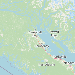
Map view of Englishman River Falls Provincial Park

Use this park location map to pinpoint Englishman River Falls Provincial Park in Canada, understand its exact geographic position, and read its mapped placement within the surrounding landscape more clearly.

Pigeon | © OpenStreetMap contributors

Location context for Englishman River Falls Provincial Park

British Columbia
Recorded earthquake history

Explore Recorded Seismic History near Englishman River Falls Provincial Park

Access a detailed archive of historical seismic events associated with the geography of Englishman River Falls Provincial Park. This collection organizes recorded earthquake data to provide a transparent look at the regional activity patterns surrounding this Vancouver Island landscape.

Englishman River Falls Provincial Park Earthquake History

Catalogued events

6 events

Strongest magnitude

Magnitude 4.3

Most recent event

Dec 11, 2014

This history includes earthquakes recorded inside the park or within 50 km of its borders

Visual reference of river cascades, canyon terrain, and old-growth coastal forest

Englishman River Falls Provincial Park Photos, Scenery, and Landscapes

Visual records capture the cascading waterfalls, steep rock canyons, and mature Douglas fir forests defining Englishman River Falls Provincial Park. Examining these protected landscapes reveals the distinct terrain, river environments, and natural features shaping the regional ecosystem.

A view of a waterfall flowing through a narrow, mossy rock canyon, surrounded by dense forest foliage, with a hiking trail railing visible on the left.

A powerful waterfall cascades through a narrow, dark rocky canyon, with logs caught on the rocks at the top and bottom of the falls.

Park atlas

Compare adjacent river canyons, coastal forests, and regional conservation landscapes.

Parks Near Englishman River Falls Provincial Park and Surrounding Protected Areas

Browsing parks near Englishman River Falls Provincial Park reveals connected coastal rainforests and river valley reserves across mid-Vancouver Island. Comparing adjacent protected landscapes provides a broader geographic perspective on regional canyon terrain and valley ecosystems.
A pale, minimalist watercolor painting depicting a wide, sandy beach shoreline with a line of evergreen trees in the distance.
State or regional parkBritish Columbia
8.6 km away#1 closest

Northeast

Rathtrevor Beach Provincial Park: Coastal Geography and Protected Land Overview

Vancouver Island coastal terrain and forested landscapes

Spanning over 300 hectares, Rathtrevor Beach Provincial Park protects a rare combination of fine sandy beaches and ancient Douglas fir groves along the Strait of Georgia. This coastal sanctuary on Vancouver Island serves as a critical habitat for migrating birds and represents a preserved segment of regional geography amidst the surrounding developed shoreline.

Area
3.47 km²
Established
1967
IUCN
II
Visitors
836.2K annual
A soft watercolor illustration depicting a winding river flowing through a lush green valley with coniferous forests on the hillsides and mountains in the background.
State or regional parkBritish Columbia
15 km away#2 closest

West

Little Qualicum Falls Provincial Park: Regional Protected Landscape and Atlas Geography

River canyon and mountain lake habitat in British Columbia

Explore the structured geography of Little Qualicum Falls Provincial Park, a protected area characterized by its sequence of dramatic river cascades and old-growth Douglas Fir stands. This entry maps the park's key natural features, including the Cameron Lake shoreline and the rugged canyon terrain of the Little Qualicum River.

Area
4.4 km²
Established
1940
IUCN
II
Relief
Mountain
A horizontal watercolor illustration featuring a wooden boardwalk winding through a calm, light-filled landscape with soft green trees, grassy foreground, and rolling hills in the distance.
State or regional parkBritish Columbia
About 23 km away#3 closest

West

MacMillan Provincial Park: Mapped Geography and Protected Forest Landscapes

Vancouver Island, British Columbia

Examine the mapped footprint of MacMillan Provincial Park, home to iconic old-growth Douglas fir trees and the Cameron River delta. This protected area serves as a biogeoclimatic transition zone, showcasing the rich, moisture-retentive coastal forest environment that defines this specific section of Vancouver Island.

Area
3.01 km²
Established
1947
IUCN
III
Visitors
543.7K annual
Watercolor painting of a tranquil body of water with gentle hills in the background and a cluster of trees on the right shore.
State or regional parkBritish Columbia
28 km away#4 closest

North

Jedediah Island Marine Provincial Park: Coastal Terrain and Regional Protected Area Map

Mapping island boundaries and sheltered maritime ecosystems

Jedediah Island Marine Provincial Park offers a unique study in coastal geography, featuring a complex shoreline of pebble beaches and indented bays. Located within the Strait of Georgia, the park serves as a protected landmass that blends maritime forest ecosystems with open water corridors. Its boat-only access ensures the landscape remains a quiet, preserved example of Gulf Islands terrain.

Area
6.03 km²
Established
1995
IUCN
II
Relief
Lowland
State or regional parkBritish Columbia
About 31 km away#5 closest

West

Horne Lake Caves Provincial Park: Mapped Protected Landscapes and Cave Networks

Vancouver Island protected area and karst geography

Horne Lake Caves Provincial Park protects a distinct array of limestone cave systems, including Main, Riverbend, and Euclataws caves. The area bridges underground geological formations with surface-level river recreation along the Qualicum River, providing a comprehensive look at the karst and forested terrain of central-eastern Vancouver Island.

Area
1.58 km²
Established
1971
IUCN
II
Relief
Upland
A minimalist watercolor illustration showing rolling hills in the background and soft foliage in the foreground on a white background.
State or regional parkBritish Columbia
About 33 km away#6 closest

East

Petroglyph Provincial Park: Protected Indigenous Heritage and Coastal Geography

Cultural landscape and bedrock carvings in British Columbia

Petroglyph Provincial Park preserves a remarkable concentration of ancient carvings etched into the sandstone bedrock of the Nanaimo River estuary. This protected area on Vancouver Island provides a rare look at how Indigenous traditions integrated with powerful natural features, offering a unique geographic context for studying historical rock art in the Pacific Northwest.

Area
0.02 km²
Established
1948
IUCN
III
Relief
Lowland
A watercolor painting showing a horizontal landscape with a green forest in the foreground and soft pink, layered rolling hills in the background.
State or regional parkBritish Columbia
38 km away#7 closest

Southeast

Morden Colliery Historic Provincial Park: Heritage Infrastructure and Regional Coal Mining History

Industrial landscape and historic rail corridor in British Columbia

Located near Nanaimo, this heritage site preserves the substantial concrete remains of the Morden Colliery. The park serves as a physical archive of southern Vancouver Island industrial life, contrasting engineering landmarks with local forest environments and interpretive trails along former coal railway alignments.

Area
0.04 km²
Established
1972
Relief
Lowland
Scope
Terrestrial
National parkBritish Columbia
57 km away#8 closest

Southwest

Pacific Rim National Park Reserve: National Park Protected Landscape & Map Atlas

Mapped boundaries and regional geographic context in British Columbia.

Pacific Rim National Park Reserve stands as a distinct protected natural landscape, serving as a critical component of Canada's national park inventory. This page facilitates an atlas-style exploration of its mapped boundaries and its position within the broader geography of British Columbia. Understanding the park's protected status and its integration with the surrounding natural terrain offers valuable insight into conservation landscapes.

Area
511 km²
Established
1970
IUCN
VI
Visitors
1.2M annual

Common questions about visiting, size, designation, and location context for Englishman River Falls Provincial Park

Englishman River Falls Provincial Park FAQs for park facts, access, geography, and protected area context

Find quick answers about Englishman River Falls Provincial Park, including protected-area facts, park geography, trail and visitor context, and how the park fits into its surrounding country and regional landscape.
MoriAtlas Explorer

Continue Your Protected Areas Search Across the Global Atlas

Deepen your exploration by continuing the structured search for national parks and protected areas worldwide. Utilize the comprehensive filtering capabilities to compare different conservation landscapes and refine your understanding of global park geography. Discover more about the distribution and characteristics of protected natural areas.

Global natural geography