
Mori Atlas logo
Nature reserveErlebach bei Ehlen

Geographic analysis of beech forests, headwater brooks, and riparian habitat corridors

Erlebach bei Ehlen Nature Reserve: Mapped Protected Landscapes in the Hoher Habichtswald

(Naturschutzgebiet Erlebach bei Ehlen)

Erlebach bei Ehlen represents a protected mosaic of forest, brook, and meadow environments on the western slopes of the Hoher Habichtswald. This nature reserve, anchored within the regional geography of Hesse, showcases the transition from closed canopy beech stands to open valley grasslands. Researchers and map enthusiasts can trace the watershed boundaries and habitat corridors that define this significant site in the northern Habichtswald.

beech forestbrook valleyriparian woodlandheadwater streamextensive grasslandhabichtswald
A stylized digital illustration of a serene nature reserve in Germany, showing rolling green hills and forests under a soft sky with warm-toned clouds.

Erlebach bei Ehlen

Nature reserve

Park overview

Structured park overview, official facts, and landscape profile for Erlebach bei Ehlen

Erlebach bei Ehlen park facts, protected area profile, and essential visitor context

Review the core facts for Erlebach bei Ehlen, including designation, size, terrain, visitor scale, habitats, and operating context in one park-focused overview.

About Erlebach bei Ehlen

Erlebach bei Ehlen lies on the north-central fringe of the Habichtswald, a low mountain range of volcanic and sedimentary origin that forms a prominent natural backdrop west of Kassel. The reserve occupies a mainly west-facing portion of the Hoher Habichtswald, capturing the transition from the forested plateau and upper slopes down into the small valley of the Erlebach.

The protected area is small in scale, roughly 34 hectares, but ecologically rich relative to its size. Much of the woodland consists of beech forest in the form characteristic of the region, with mature stands that have developed under conventional forestry management or, in places, with only light historical disturbance. Along the upper Erlebach and its small tributary brooks, the forest composition shifts into a more moisture-influenced, species-rich riparian woodland, reflecting the constant influence of spring-fed water.

Below the forest line, the brook valley opens into a network of extensively managed grasslands. These meadows and pastures are only lightly used and are framed by lines of shrubs and trees that follow the course of the Erlebach. The combination of closed beechwood, narrow gallery forest along the brook, and traditional open grassland gives the reserve a layered, mosaic-like character that is typical of well-conserved valleys in the Habichtswald.

Its formal protection status is twofold. Since 2 January 1996 it has been a designated Naturschutzgebiet under Hessian law, a designation that strictly regulates land use within its boundaries. At the same time, it forms part of the larger FFH site "Habichtswald und Seilerberg bei Ehlen," bringing it into the European network of habitats protected under the EU Habitats Directive and reinforcing the importance of its beech and brook habitats at a transnational scale.

Quick facts and research context for Erlebach bei Ehlen

Erlebach bei Ehlen is a Hessian Naturschutzgebiet in Landkreis Kassel, established on 2 January 1996 under area number 1633039. It covers about 34.2 hectares within the Naturpark Habichtswald, on the western slopes of the Hoher Habichtswald.

The reserve is part of the larger FFH (Fauna-Flora-Habitat) site "Habichtswald und Seilerberg bei Ehlen" and is recorded in the World Database on Protected Areas under WDPA ID 162969. It is characterized by beech forest, brook-influenced riparian woodland, and extensively used grasslands along the headwaters of the Erlebach stream.

Protection and recognition

Examine the official protection status and global designation records for Erlebach bei Ehlen.

Erlebach bei Ehlen Protection Status and International Recognition Data

Erlebach bei Ehlen protection status details compile available administrative records and official registry entries for the protected area. Structured database fields provide verified conservation classifications without assuming unverified management outcomes.

Protection details

WDPA ID
162969
Park context

Deeper park guide and search-rich context for Erlebach bei Ehlen

Erlebach bei Ehlen history, landscape, wildlife, and travel context

Explore Erlebach bei Ehlen through its history, landscape character, ecosystems, wildlife, conservation priorities, cultural context, and seasonal travel timing in a structured park guide built for atlas discovery and search intent.

Why Erlebach bei Ehlen stands out

Erlebach bei Ehlen is best known for its combination of near-natural beech forest and intact headwater brook habitat on the slopes of the Hoher Habichtswald. The reserve exemplifies the classic Habichtswald landscape pattern: closed canopy beechwoods on the hill slopes, narrow strips of alder and ash riparian forest along the brooks, and traditionally managed grasslands further down the valley. Its recognition at the European level through inclusion in the FFH network underscores the habitat value of these old-growth-influenced beech stands and the small, ecologically important brook corridors of the northern Habichtswald.
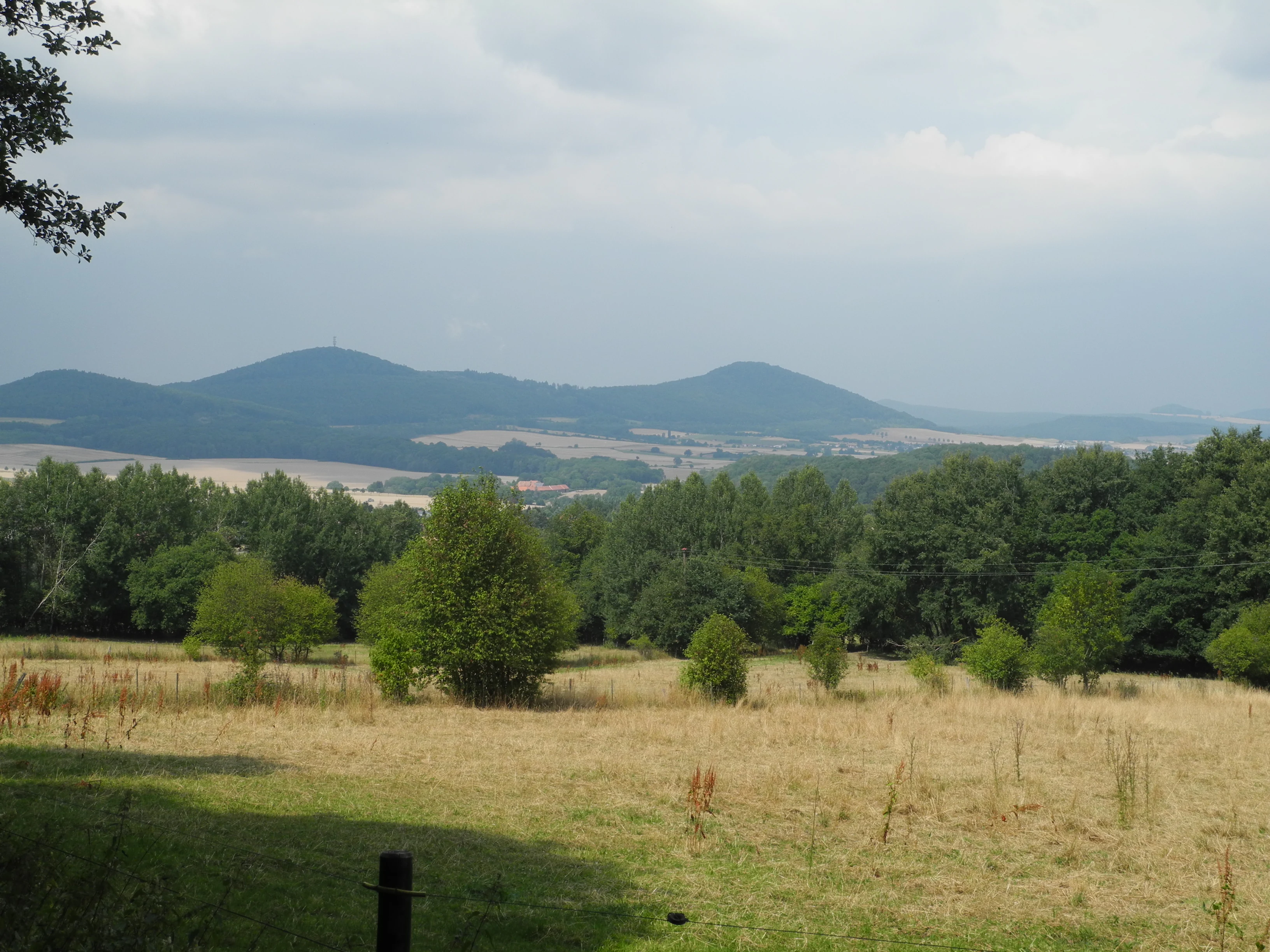
A wide landscape view of golden meadows in the foreground, transitioning to a dense green forest, with rolling hills and mountains in the distance under a cloudy sky.
A scenic view over the meadows and forest landscape of the Erlebach bei Ehlen nature reserve.

Erlebach bei Ehlen history and protected-area timeline

The area that is today Erlebach bei Ehlen was placed under formal nature protection on 2 January 1996, when the Hessian authorities designated it as a Naturschutzgebiet with the official area number 1633039. The designation reflected an effort to safeguard a representative section of the western Habichtswald, including both its forest communities and the headwaters of the Erlebach stream, at a time when small, ecologically valuable brook valleys in the region were increasingly affected by forestry and agricultural intensification.

In parallel, the reserve was incorporated into the larger FFH site "Habichtswald und Seilerberg bei Ehlen," tying its long-term protection to European Habitats Directive objectives. The reserve therefore operates under a dual framework of Hessian nature conservation law and EU-level habitat protection, which together govern forestry, agriculture, and other land uses within the area.

Erlebach bei Ehlen landscape and geographic character

Erlebach bei Ehlen occupies a predominantly west-exposed section of the Hoher Habichtswald, the higher part of the Habichtswald range west of Kassel. The terrain undulates between forested slopes and the narrow valley of the Erlebach, with the slopes generally descending from east to west toward the stream.

Within this setting, the landscape divides into three interlocking elements. The hill slopes and upper reaches are cloaked in closed forest, dominated by beech. The small valley floor is defined by the headwater brooks of the Erlebach, which cut shallow channels through the forest before joining to form the main stream. Further down the valley and to the west, the forest gives way to open, extensively used grasslands, with the Erlebach continuing through them, flanked by lines of shrubs and trees.

To the east, the reserve borders a Landesstraße (state road), which effectively marks the boundary between the protected mosaic of forest, brook, and meadow and the more heavily used landscape around the Habichtswald settlements, including Ehlen.

Erlebach bei Ehlen ecosystems, habitats, and plant life

The ecological core of Erlebach bei Ehlen lies in its beech forests and its small, spring-fed brook system. The dominant forest type is beechwood of the kind typical of the middle elevations of the Habichtswald, tending toward mature stands with relatively continuous canopies on the slopes of the Hoher Habichtswald. These forests provide the structural and microclimatic conditions associated with Central European montane and submontane beech habitats.

Along the headwater brooks of the Erlebach, the vegetation changes markedly. Here the forest takes on a riparian character rich in alder and other moisture-demanding species, forming narrow strips of Auwald that frame the watercourses and link the upper forest to the lower valley. This combination of dry beechwood on the slopes and wet gallery woodland along the brooks is one of the defining ecological features of the reserve.

Further west, the forests are replaced by extensively managed grasslands, traditionally mown or grazed at low intensity. The transition between forest, riparian shrub and tree lines, and open meadow produces a varied habitat mosaic that supports the typical flora and fauna of well-conserved low mountain brook valleys in northern Hesse.

Erlebach bei Ehlen wildlife and species highlights

The specific wildlife communities of Erlebach bei Ehlen are shaped by the interplay of beech forest, riparian woodland, and extensively managed meadow along a small brook valley. The mature and semi-mature beech stands provide habitat for forest-interior bird species and a range of saproxylic insects associated with old broadleaf trees.

The cool, shaded brook corridors with their alder and ash-dominated gallery woodland offer habitat for stream-dependent invertebrates, amphibians, and other moisture-loving species, while the open meadows and their bordering hedges and shrub lines create foraging and nesting opportunities for meadow birds and pollinators. The combination of these habitats in a single small-scale reserve is its principal wildlife value, rather than any single flagship species.

Erlebach bei Ehlen conservation status and protection priorities

Erlebach bei Ehlen is significant from a conservation perspective because it conserves a representative and relatively intact example of a Habichtswald brook valley, with its full sequence of beech forest, riparian woodland, and traditionally used grassland. Such mosaics have become rare across much of the low mountain ranges of central Germany, where forestry intensification, grassland reclamation, and brook regulation have reduced the extent and connectivity of natural habitats.

The reserve's formal protection is twofold. As a Hessian Naturschutzgebiet, established in 1996, it benefits from strict regulations governing land use, forestry, agriculture, and development within its boundaries. Its inclusion in the FFH site "Habichtswald und Seilerberg bei Ehlen" additionally secures the area under the EU Habitats Directive, ensuring that its beech and brook habitats are monitored and maintained in the framework of the European Natura 2000 network.

Erlebach bei Ehlen cultural meaning and human context

The reserve lies within the traditional cultural landscape of the Habichtswald, a region historically shaped by forestry, small-scale agriculture, and dispersed villages such as Ehlen, which belongs to the municipality of Habichtswald. The extensively managed meadows and the lines of trees and shrubs that frame the Erlebach reflect long-standing local land use, in which forest, brook, and grassland were managed as an integrated whole rather than as separate economic spaces.

The nearby Landesstraße to the east and the broader setting west of Kassel place the reserve at the interface between an actively used rural and peri-urban landscape and a deliberately protected natural core, a relationship that has come to characterize many of the surviving, high-value habitat patches in the low mountain ranges around Kassel.

Top sights and standout views in Erlebach bei Ehlen

Key features of Erlebach bei Ehlen include its position on the western slopes of the Hoher Habichtswald within the Naturpark Habichtswald, its beech-dominated hill forests, and the intact headwater brooks of the Erlebach with their riparian alder woodland. The transition from closed forest to extensively managed grassland along the same short valley gives the reserve a compact but unusually varied habitat mosaic.

Equally noteworthy is its dual protection as a Hessian Naturschutzgebiet and as part of the EU FFH site "Habichtswald und Seilerberg bei Ehlen," which anchors it in both regional and European nature conservation frameworks.

Best time to visit Erlebach bei Ehlen

Erlebach bei Ehlen can be visited throughout much of the year, and the best timing depends on what kind of experience is sought. Late spring and early summer bring fresh foliage in the beech canopy, full groundwater levels in the brooks, and actively flowering meadows and brook-side vegetation, making it a strong period for experiencing the habitat mosaic at its most lush.

In autumn, the beech forests turn color and the lower light penetrates deeper into the otherwise shaded valley, while the extensively used grasslands have typically been mown or grazed, opening up views across the valley floor. Winter visits offer a quieter, more structural view of the reserve, with the bare deciduous canopy making the pattern of forest, riparian woodland, and open meadow particularly easy to read. Because the area is a nature reserve, visitors should keep to existing paths and avoid disturbing the habitats in any season.

Monthly climate preview

Measured monthly temperature ranges and precipitation patterns across the protected landscape

Erlebach bei Ehlen Climate Normals and Long Term Temperature Records

Historical monitoring data from NASA POWER outlines long term average temperature variations and monthly precipitation rates recorded at representative terrain elevations in Hesse. Reviewing twelve month climatological normals provides structural context for analyzing annual weather rhythms within Erlebach bei Ehlen.
Annual mean8 °C
-1 °C18 °C
Jan-1°
Feb
Mar
Apr
May12°
Jun16°
Jul18°
Aug18°
Sep14°
Oct
Nov
Dec
Warmest month
July

18 °C

Coolest month
January

-0.6 °C

Wettest month
July

2.5 mm/day

Driest month
April

1.5 mm/day

Park location guide

Geography guide, regional context, and park location map for Erlebach bei Ehlen

Erlebach bei Ehlen park geography, regions, and map view in Germany

Understand where Erlebach bei Ehlen sits in Germany through a broader geographic reading of the surrounding landscape, nearby location context, and its mapped position within the national park landscape.

How Erlebach bei Ehlen fits into Germany

Germany is a federal republic in Western and Central Europe with a population of over 83 million across sixteen constituent states. It is Europe's largest economy by nominal GDP and a major global exporter and importer. The capital is Berlin, and the country borders Denmark, Poland, Czech Republic, Austria, Switzerland, France, Luxembourg, Belgium, and the Netherlands.

Wider geography shaping Erlebach bei Ehlen in Germany

Germany is located in Western and Central Europe, spanning 357,022 km². It borders Denmark to the north, Poland and the Czech Republic to the east, Austria and Switzerland to the south, and France, Luxembourg, Belgium, and the Netherlands to the west. The country has coastlines on the Baltic Sea and North Sea to the north, with the Alps located in the southern region.

Map view of Erlebach bei Ehlen

Use this park location map to pinpoint Erlebach bei Ehlen in Germany, understand its exact geographic position, and read its mapped placement within the surrounding landscape more clearly.

Pigeon | © OpenStreetMap contributors

Location context for Erlebach bei Ehlen

Hesse

Visualizing the beech forests, headwater brooks, and valley terrain of northern Hesse

Erlebach bei Ehlen Photos and Protected Landscape Scenery

Visual documentation captures the mature beech stands and intricate headwater brook corridors defining the protected terrain of Erlebach bei Ehlen. Photographic references illustrate the shifting topography from closed mountain slopes down to the open valley grasslands.

A wide landscape view of golden meadows in the foreground, transitioning to a dense green forest, with rolling hills and mountains in the distance under a cloudy sky.

Park atlas

Compare regional mountain forests, stream valleys, and protected habitats across northern Hesse.

Explore Parks Near Erlebach bei Ehlen and Surrounding Protected Landscapes

Browse nearby protected areas and related low mountain reserves that share the ecological traits of Erlebach bei Ehlen. Comparing these surrounding landscapes reveals broader regional patterns in beech forest conservation and brook valley habitats.
A horizontal watercolor painting depicting a soft, rolling landscape with green hills, conifer trees, and misty purple mountains in the background against a white backdrop.
Nature reserveLandkreis Kassel
About 4.3 km away#1 closest

North

Dörnberg Nature Reserve: Geographic Map and Protected Landscape Overview in Landkreis Kassel

Analyzing the limestone slopes and volcanic terrain of the Dörnberg massif.

Explore the Dörnberg nature reserve through a geographic lens, focusing on its protected status within the Landkreis Kassel region. This area encompasses 116 hectares of steep limestone slopes, supporting a dense collection of calcareous grasslands and rare orchid species. The site is physically defined by its striking Miocene basalt outcrop, providing a clear focal point for studying regional Hessian topography and conservation-led land management.

Area
1.166 km²
Established
1978
Relief
Mountain
Climate
Temperate
Watercolor painting of a soft, rolling landscape with green fields, distant hills, and low foreground vegetation.
Protected areaGermany
About 5.3 km away#2 closest

South

Langenberger Huete bei Breitenbach: Mapped Geography and Protected Area Landscape Context

Nature reserve terrain and grassland boundaries in northern Hesse

Examine the geographic layout of Langenberger Huete bei Breitenbach, a protected dry grassland area near Schauenburg, Germany. This site preserves open meadow habitats along the forested Langenberg ridge, offering insight into traditional land use and small-scale conservation within the Habichtswald region. Access detailed boundary data and terrain information to understand its position within the surrounding agricultural and woodland zones.

Area
0.14 km²
Established
1992
Relief
Upland
Climate
Temperate
A watercolor painting in soft pastel tones showing a winding river or path flanked by small clusters of green trees, with gently rolling hills in the background against a white backdrop.
Nature reserveKassel
About 6.4 km away#3 closest

Southeast

Dönche Nature Reserve: Investigating the Protected Landscapes and Urban Geography of Kassel

Exploring the historic grassland and wetland mosaic in northern Hesse

Dönche serves as a primary example of an inner-city nature reserve in Germany, preserving 170 hectares of open countryside within the Kassel urban fabric. Its landscape is shaped by the Dönchebach and Krebsbach streams, forming a rhythmic structure of ponds, beech wood pastures, and tall herb communities that offer a deep look into regional ecology and historical land use.

Area
1.709 km²
Established
1983
Water
Minor water
A horizontal watercolor painting showing a soft, hazy landscape with green hills, patches of grass, and purple-tinted distant mountains under a white sky.
Nature reserveLandkreis Kassel
About 7.1 km away#4 closest

Northeast

Keischel bei Weimar: Nature Reserve Protected Area and Regional Geography

A calcareous grassland mosaic in the Landkreis Kassel district

Keischel bei Weimar preserves a 19.7-hectare landscape defined by Muschelkalk limestone bedrock and traditional agricultural practices. This nature reserve serves as a critical refuge for specialized flora and insect species, showcasing the value of integrated land management within the broader West Hessian Depression and northern Hesse regional geography.

Area
0.197 km²
Established
1992
Relief
Upland
Climate
Temperate
A soft watercolor painting depicting rolling green hills against a faint, light-colored background.
Nature reserveHessen
About 7.4 km away#5 closest

West

Festberg bei Philippinenthal Nature Reserve: Geography and Protected Landscape Context

A rare calcareous grassland ecosystem in northern Hessen.

Festberg bei Philippinenthal encompasses a ridge of tilted Muschelkalk limestone rising above the Lohbach stream in Hessen. This nature reserve protects a vital combination of juniper heath, dry calcareous grassland, and small-scale forest habitats maintained by historic and modern conservation grazing, offering a clear example of local geology shaping biodiversity.

Area
0.143 km²
Established
1992
IUCN
IV
A horizontal watercolor painting depicting a calm wetland landscape with soft green trees, grassy banks, and rolling hills in the background.
Nature reserveHesse
About 10 km away#6 closest

West

Glockenborn bei Bründersen Nature Reserve: Regional Geography and Wetland Protected Areas

A mapped overview of wetland terrain in northern Hesse

Glockenborn bei Bründersen offers a focused look at how managed wetlands integrate into the agricultural landscape of northern Hesse. Known for its distinct shallow lakes and bird-rich environments, this nature reserve serves as an essential case study in ecological restoration and the maintenance of open grazing lands within a protected boundary.

Area
0.07 km²
Established
2004
A soft watercolor illustration of a winding stream flowing through a green meadow with rolling hills in the background and a small cluster of pine trees in the foreground.
Nature reserveHessen
About 11 km away#7 closest

Northeast

Jungfernbach und Brandteich bei Calden: Protected Forest and Stream Valley Geography

Regional nature reserve landscape located in northern Hessen

Examine the mapped boundaries and natural terrain of Jungfernbach und Brandteich bei Calden. This nature reserve offers a detailed look at lowland stream corridors, pond ecosystems, and riparian forest patches nestled within the rolling landscape of northern Hessen, reflecting the region's diverse protected land character.

Area
0.343 km²
Established
1985
Nature reserveHessen
About 13 km away#8 closest

West

Dörneberg bei Viesebeck: Protected Calcareous Grassland and Beech Forest in Hessen

Mapped nature reserve and orchid-rich protected landscape in northern Hessen.

Located in the Hessen region of Germany, Dörneberg bei Viesebeck is a carefully managed nature reserve characterized by its thin, lime-rich soils and diverse habitat mosaic. The reserve preserves rare calcareous dry grasslands, historical quarry features, and orchid-bearing beech woodlands. As part of a protected Natura 2000 site, it offers a condensed look at the ecologically significant limestone landscapes found within northern Hessen.

Area
0.256 km²
Established
1982

Common questions about visiting, size, designation, and location context for Erlebach bei Ehlen

Erlebach bei Ehlen FAQs for park facts, access, geography, and protected area context

Find quick answers about Erlebach bei Ehlen, including protected-area facts, park geography, trail and visitor context, and how the park fits into its surrounding country and regional landscape.
MoriAtlas Explorer

Continue Your Protected Areas Search Across the Global Atlas

Deepen your exploration by continuing the structured search for national parks and protected areas worldwide. Utilize the comprehensive filtering capabilities to compare different conservation landscapes and refine your understanding of global park geography. Discover more about the distribution and characteristics of protected natural areas.

Global natural geography