Mori Atlas logo
Nature reserveRéserve naturelle régionale d'Errota Handia

A detailed geographic study of Basque wetland habitats and historic millpond terrain

Mapping the Protected Landscapes of Réserve naturelle régionale d'Errota Handia in Nouvelle-Aquitaine

Réserve naturelle régionale d'Errota Handia represents a critical protected wetland area in the Basque Country of southwestern France. This geographic profile examines the park boundaries and habitat mosaic, ranging from the central millpond and damp meadows to the surrounding oak woodlands. Through mapped terrain analysis, gain insight into how this compact nine-hectare site preserves high biodiversity and historical water management structures.

wetlandmillpondBasque Countryregional nature reservebirdwatchingprivate reserve

Réserve naturelle régionale d'Errota Handia

Nature reserve

Park overview

Structured park overview, official facts, and landscape profile for Errota Handia Regional Nature Reserve

Errota Handia Regional Nature Reserve park facts, protected area profile, and essential visitor context

Review the core facts for Errota Handia Regional Nature Reserve, including designation, size, terrain, visitor scale, habitats, and operating context in one park-focused overview.

About Errota Handia Regional Nature Reserve

Errota Handia is a small but ecologically dense protected wetland in the northern Basque Country of southwestern France. Straddling the commune of Arcangues in the Pyrénées-Atlantiques, it sits just inland from the Atlantic coast at the headwaters of the Uhabia river. Although it covers only around nine hectares, the reserve is unusually rich in habitat variety and wildlife for its size, which is why it has been protected under successive nature reserve designations since 2001.

At the heart of the reserve is the Etang d'Errota Handia, a millpond of about two hectares that is fed by the small Alotz stream. Around this pond the landscape unfolds as a mosaic of wet meadows, mesophile grasslands, tall-herb marsh communities known as megaphorbiaies, and several types of woodland: acidophilous oak forests, willow swamp, and alder groves. Nineteen distinct habitat types have been catalogued within the reserve's perimeter, giving it an ecological diversity more typical of much larger protected areas.

The reserve is privately owned and is not open for free public visits, but guided excursions are organized by the Conservatoire d'espaces naturels d'Aquitaine, which manages the site. Its combination of cultural heritage (the old mill documented since at least 1893) and ecological richness has made it a useful reference site for regional conservation strategies in Nouvelle-Aquitaine.

Quick facts and research context for Errota Handia Regional Nature Reserve

Errota Handia Regional Nature Reserve is located in the commune of Arcangues, in the Pyrénées-Atlantiques department of southwestern France, within the Nouvelle-Aquitaine region and the historical Basque Country. It lies less than ten kilometers from the Atlantic coast, at the head of the Uhabia river catchment.

The reserve covers approximately nine hectares and is classified as a regional nature reserve (RNR) under IUCN Category IV. It was first established as a voluntary nature reserve (RNV) in 2001 and was reclassified as a regional nature reserve in 2008. Today it is managed by the Conservatoire d'espaces naturels d'Aquitaine, with a focus on wetland, woodland, and meadow conservation alongside historical heritage tied to an old water mill.

Protection and recognition

Review documented protected area designation data and administrative records.

Protection Status and International Recognition for Réserve naturelle régionale d'Errota Handia

Examine the formal protection status and recorded administrative framework associated with Réserve naturelle régionale d'Errota Handia. Access verified database identifiers and official designation history for comprehensive geographical research.

Protection details

WDPA ID
555514355
Park context

Deeper park guide and search-rich context for Errota Handia Regional Nature Reserve

Errota Handia Regional Nature Reserve history, landscape, wildlife, and travel context

Explore Errota Handia Regional Nature Reserve through its history, landscape character, ecosystems, wildlife, conservation priorities, cultural context, and seasonal travel timing in a structured park guide built for atlas discovery and search intent.

Why Errota Handia Regional Nature Reserve stands out

Errota Handia is best known for its role as a small but exceptionally biodiverse wetland reserve in the northern Basque Country. The Etang d'Errota Handia and its surrounding habitats support a remarkable concentration of birds, mammals, dragonflies, and butterflies, including rare and protected species such as the European mink, the Booted Eagle, the Marsh Harrier, and the Osprey. The reserve is also notable for being built on a site with deep historical roots: a seventeenth-century mill that once operated on a much larger reservoir than the pond seen today, and for combining ecological protection with the heritage of the Basque countryside near the Pyrenees foothills.

Errota Handia Regional Nature Reserve history and protected-area timeline

The site of Errota Handia has a documented human history going back to at least the seventeenth century, when a mill was built on the Alotz stream. The mill appears in a drawing in the 1893 book 'Pêches et chasses zoologiques' by Léopold de Folin, and it remained in operation, powered by a roughly seven-hectare reservoir, until the mid-1930s.

The contemporary nature reserve emerged from the initiative of the site's owner, Jean-François Terrasse, a well-known ornithologist and co-founder, with his brother Michel, of the Fonds d'intervention pour les rapaces (FIR) at the LPO. Working with the Conservatoire d'espaces naturels d'Aquitaine, he sought formal protection for the pond and its surrounding habitats.

In 2001, this effort led to the creation of a voluntary nature reserve (Réserve naturelle volontaire, RNV) by prefectoral decree, followed by reclassification as a regional nature reserve (Réserve naturelle régionale) in 2008. The site's old dam, which extends about 150 meters with a height of between two and five meters, had to be reinforced after severe flooding in 2007, underscoring both the historical and the continuing hydrological importance of the place.

Errota Handia Regional Nature Reserve landscape and geographic character

The landscape of Errota Handia is shaped primarily by water. The central feature is a small millpond, the Etang d'Erota Handia, sitting at the head of the Uhabia basin and straddled by the Alotz stream, which feeds it from upstream. The surrounding topography is gentle, typical of the rolling Basque countryside just inland from the Atlantic coast, with elevations low enough to support persistent wetland conditions.

Around the pond, the terrain transitions through a series of clearly defined ecological zones. Damp and mesophile meadows give way to tall-herb marsh vegetation in the wettest sectors, while broadleaved woodland closes in along the slopes and watercourses. The woodland communities include acidophilous oak forest on drier ground and wet willow and alder woods along the margins of the stream and pond.

A key piece of the engineered landscape is the historic dam, a 150-meter structure between two and five meters high that still regulates the pond. Although the original mill reservoir was much larger than today's pond, the surviving hydraulic infrastructure remains the defining physical element of the site and a constant reminder of the landscape's long agricultural and industrial history.

Errota Handia Regional Nature Reserve ecosystems, habitats, and plant life

Ecologically, Errota Handia punches well above its weight. The reserve's mere nine hectares contain a mosaic of habitats including standing freshwater, wet meadows, mesophile grasslands, megaphorbiaie tall-herb marsh, acidophilous oak forest, willow swamp, and alder groves. Nineteen distinct habitat types have been identified within this small perimeter, providing a striking example of habitat compression in the Basque piedmont.

The flora is correspondingly diverse, with around 250 plant species recorded in the reserve. Although none are formally protected at the national level, the assemblage includes charismatic and ecologically indicative species such as Royal Fern, Hornbeam, Common Tutsan, and Great Burnet, which together reflect the transitional character of the habitats between wetland and woodland.

Hydrology is the ecological backbone of the site. The Alotz stream and the impoundment ensure year-round moisture, creating conditions favorable to amphibian reproduction, dragonfly development, and the rich invertebrate communities that in turn support the site's notable birdlife. Maintaining water quality and natural water levels has therefore been a central preoccupation of reserve managers since the reserve's creation.

Errota Handia Regional Nature Reserve wildlife and species highlights

The wildlife of Errota Handia is one of its main justifications for protection. Surveys have documented roughly 320 animal species across the reserve, despite its modest size. Mammals include two species of particular conservation interest: the European Mink, one of Europe's rarest carnivores, and the European Polecat, both of which find refuge in the wetland and riparian habitats.

Birds are the most conspicuous wildlife group, with about 140 species recorded, including twenty-seven listed under Annex I of the European Birds Directive. These include the Little Grebe, Booted Eagle, Marsh Harrier, and Osprey, alongside a rich supporting cast that features the Common Kingfisher, Grey Heron, Black Kite, Purple Heron, Black and White Storks, Red Kite, Night Heron, European Honey Buzzard, and European Nightjar. The pond, meadows, and woodland edge together create an unusually varied feeding landscape for raptors, waterbirds, and woodland species alike.

Reptiles and amphibians further enrich the fauna. Seven reptile species, including the Smooth Snake, and six amphibian species breed in or around the reserve. Invertebrate diversity is also exceptional: thirty-eight species of dragonflies (including the Mercury Bluet and the Orange-spotted Emerald), sixty butterflies, and eighty-two moths have been catalogued, along with conspicuous beetles such as the Stag Beetle and the Great Capricorn Beetle, the latter being an indicator of veteran oak presence.

Errota Handia Regional Nature Reserve conservation status and protection priorities

Errota Handia was established as a voluntary nature reserve in 2001 and consolidated as a regional nature reserve in 2008, formalizing an effort to protect a small but exceptionally rich wetland complex in the northern Basque Country. Its IUCN Category IV designation reflects its role in preserving specific species and habitats rather than a large-scale ecosystem, but the density of biodiversity per hectare is high.

A central conservation focus has been the control of invasive species that threaten the integrity of the pond and its margins. Nutria are managed through trapping programs, while the aquatic plant Ludwigia (commonly known as Jussie) is monitored and manually removed to prevent it from dominating the open water and shoreline habitats.

Management of the reserve is carried out by the Conservatoire d'espaces naturels d'Aquitaine under a 2007-2011 management plan that has guided habitat restoration, monitoring, and public engagement. Reinforcement of the historic dam after the major floods of 2007 also illustrated the need for ongoing hydraulic management to maintain both the wetland habitats and the surrounding mosaic of woodlands and meadows.

Errota Handia Regional Nature Reserve cultural meaning and human context

The name Errota Handia is a direct translation in Basque: 'errota' meaning mill and 'handia' meaning big, together 'the big mill.' This bilingual identity anchors the reserve firmly within the cultural landscape of the French Basque Country, where industrial heritage and traditional land use remain an important part of contemporary identity.

The seventeenth-century mill and its associated reservoir, documented since at least 1893, represent a long tradition of small-scale water power on the streams flowing down toward the Atlantic. Although the mill ceased operation in the mid-twentieth century, the surviving dam, pond, and mill-related structures remain integral to the site's character and are protected alongside its natural values.

Ownership of the reserve by the ornithologist Jean-François Terrasse, co-founder with his brother Michel of the Fonds d'intervention pour les rapaces, links the site to the broader French tradition of naturalist-led private conservation and to the work of the Ligue pour la Protection des Oiseaux in the region.

Top sights and standout views in Errota Handia Regional Nature Reserve

Errota Handia stands out for combining a compact Basque wetland with exceptional biodiversity density. Nineteen habitat types, 250 plant species, 320 animal species, and 140 bird species have been recorded on just over nine hectares, including the European Mink, Booted Eagle, Marsh Harrier, and Osprey.

The reserve's cultural layer is equally distinctive. A seventeenth-century mill and its 150-meter dam give the site a tangible historical identity, while the Basque name 'big mill' reflects its place in the regional Pays Basque heritage. Managed by the Conservatoire d'espaces naturels d'Aquitaine, Errota Handia illustrates how small private reserves can play a disproportionate conservation role in culturally rich landscapes near the Atlantic coast.

Best time to visit Errota Handia Regional Nature Reserve

Errota Handia lies in the mild oceanic climate of the northern Basque Country, where winters are generally wet and mild and summers are moderately warm. Spring and early summer tend to bring rich bird activity around the pond and meadows, with breeding waterbirds, raptors, and passerines most visible at this time, while dragonflies and butterflies are most abundant in late spring and summer.

Autumn and winter can also be rewarding for bird enthusiasts, as visiting waterbirds and overwintering species use the pond and adjacent habitats. Because the reserve is private and only open via guided visits organized by the Conservatoire d'espaces naturels d'Aquitaine, prospective visitors should plan around scheduled outings and reasonable weather rather than aim for any specific calendar window.
Monthly climate preview

Long-term representative point measurements of monthly temperature and precipitation variation

Climate Normals and Annual Weather Rhythms for Réserve naturelle régionale d'Errota Handia

Representative coordinate records show measured monthly temperature variations spanning from cold winter lows to warm summer highs alongside shifting precipitation rates. Examining the complete twelve-month climatology profile reveals detailed long-term weather patterns across the protected landscape.
Annual mean14 °C
7 °C22 °C
Jan
Feb
Mar10°
Apr12°
May15°
Jun18°
Jul21°
Aug22°
Sep19°
Oct15°
Nov10°
Dec
Warmest month
August

21.6 °C

Coolest month
January

7 °C

Wettest month
November

4.7 mm/day

Driest month
July

1.8 mm/day

Park location guide

Geography guide, regional context, and park location map for Errota Handia Regional Nature Reserve

Errota Handia Regional Nature Reserve park geography, regions, and map view in France

Understand where Errota Handia Regional Nature Reserve sits in France through a broader geographic reading of the surrounding landscape, nearby location context, and its mapped position within the national park landscape.

How Errota Handia Regional Nature Reserve fits into France

France is a unitary semi-presidential republic and one of the world's largest economies. It borders Belgium, Luxembourg, Germany, Switzerland, Italy, Monaco, Andorra, and Spain, with a maritime border to the United Kingdom. The country is known for its cultural influence, art, cuisine, and political history spanning centuries.

Wider geography shaping Errota Handia Regional Nature Reserve in France

France is located in Western Europe. Metropolitan France extends from the Rhine to the Atlantic Ocean and from the Mediterranean Sea to the English Channel and North Sea. The country borders Belgium, Luxembourg, Germany, Switzerland, Italy, Monaco, Andorra, Spain, and has a maritime border with the United Kingdom.

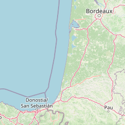
Map view of Errota Handia Regional Nature Reserve

Use this park location map to pinpoint Errota Handia Regional Nature Reserve in France, understand its exact geographic position, and read its mapped placement within the surrounding landscape more clearly.

Pigeon | © OpenStreetMap contributors

Location context for Errota Handia Regional Nature Reserve

Nouvelle-Aquitaine
Park atlas

Compare regional wetlands, woodlands, and protected landscapes across the Basque countryside

Parks Near Réserve naturelle régionale d'Errota Handia and Surrounding Protected Areas

Browsing other protected areas near Réserve naturelle régionale d'Errota Handia reveals shared wetland habitats and regional conservation corridors across southwestern France. Comparing these nearby nature reserves provides deeper geographic context for the diverse ecological zones found throughout the northern Basque hinterland.
A soft watercolor illustration showing rolling green hills, patches of trees, and a distant horizon in shades of light green and pale yellow.
Nature reserveNouvelle-Aquitaine
About 44 km away#1 closest

Northeast

Réserve naturelle régionale du site des carrières de Tercis-les-Bains Protected Landscape

Geological stratotype and Cretaceous fossil reference site in Nouvelle-Aquitaine

This unique nature reserve in southwestern France protects a globally significant Cretaceous geological sequence within former limestone quarries. It serves as a vital scientific landmark for stratigraphy, housing extensive fossil records and structural evidence of salt-driven geology, all set within the scenic terrain of the Adour river basin.

Area
0.448 km²
Established
2015
IUCN
IV
Relief
Lowland
Biosphere reserveBasque Country
About 86 km away#2 closest

West

Reserva de la biosfera de Urdaibai: Protected Coastal and Estuarine Geographic Atlas

Mapping wetlands, forests, and cliffs in the Basque Country

Explore the complex terrain of Reserva de la biosfera de Urdaibai, spanning the tidal Oka estuary to the peaks of Mount Oiz. This protected landscape is defined by its vast saltmarshes, Cantabrian oak forests, and dramatic coastal cliffs that anchor the natural geography of the Basque Country.

Area
224.52 km²
Established
1984
Relief
Mixed relief
Climate
Temperate
National parkHautes-Pyrénées
About 89 km away#3 closest

Southeast

Pyrénées National Park: Protected Landscape & Transboundary Protected Area Atlas

Discover Hautes-Pyrénées' dramatic glacial terrain and alpine environments.

Pyrénées National Park is a significant protected area in France's Hautes-Pyrénées department, renowned for its dramatic glacial cirques, high-altitude lakes, and extensive mountain landscapes. Established as a national park, it offers rich geographic context for atlas exploration, showcasing millions of years of geological formation shaped by tectonic uplift and glacial carving. This park is also notable for its transboundary conservation efforts with Spain, contributing to a broader protected region. Explore its unique terrain, from towering limestone formations to alpine meadows, and understand its place within the Pyrenean mountain range.

Area
458 km²
Established
1967
IUCN
II
Relief
Mountain
Nature reservePyrénées-Atlantiques
About 109 km away#4 closest

Southeast

Vallée du Soussouéou Protected Nature Reserve: Geographic Atlas and Mountain Terrain

A roadless glacial valley in the French Pyrénées-Atlantiques

Vallée du Soussouéou offers a rare glimpse into a roadless Pyrenean landscape. This protected area features a classic glacial U-shaped valley, significant peatland ecosystems, and diverse alpine habitats that support Pyrenean fauna. As a quiet extension of the ecological network in the Western Pyrenees, the valley remains an important site for understanding mountain geography and glacial geomorphology in southwestern France.

Area
45.39 km²
Established
1995
Relief
Mountain
Scope
Terrestrial
A watercolor illustration of rolling mountain ranges and stylized forest patches in soft green and earth tones against a pale background.
Nature reserveOccitanie
About 118 km away#5 closest

East

Réserve naturelle régionale du massif du Pibeste-Aoulhet: Mountain Reserve Atlas

Regional protected landscape mapping in the French Pyrenees

Spanning over 5,000 hectares in the Occitanie region, the Réserve naturelle régionale du massif du Pibeste-Aoulhet serves as a critical biological corridor. This detailed record examines the massif's varied elevations, from lower broadleaf forests to high-altitude rocky cliffs, highlighting its status as one of the largest regional nature reserves in France.

Area
51.103 km²
Established
2012
IUCN
IV
Relief
Mountain
Biosphere reserveLa Rioja
About 133 km away#6 closest

South

Valles del Jubera, Leza, Cidacos y Alhama: Protected Landscapes in La Rioja, Spain

A biosphere reserve featuring limestone gorges and dinosaur fossil sites

Valles del Jubera, Leza, Cidacos y Alhama forms a distinct mid-mountain region in northern Spain where four river valleys have carved deep passages into the earth. The area serves as a vital protected landscape containing rich paleontological history, thermal springs, and traditional Mediterranean forests. This atlas entry details the natural boundaries and geographic character of one of Spain's significant biosphere reserves.

Area
1,196.69 km²
Established
2003
Watercolor painting showing a mountain range with a winding river through a valley
National parkSpain
About 142 km away#7 closest

Southeast

Ordesa y Monte Perdido National Park: Glacial Terrain and Pyrenean Protected Landscape

Explore its dramatic valleys, cliffs, and alpine geography.

Ordesa y Monte Perdido National Park is a critical protected area within the Pyrenean geography, defined by its spectacular glacial valleys, towering limestone massifs, and unique karst formations. As a National Park and UNESCO World Heritage Site, it offers a rich environment for exploring mapped terrain and understanding the interplay of geology and high-alpine ecosystems. Delve into the mapped boundaries and distinct landscape features that characterize this significant protected landscape.

Area
156.08 km²
Established
1918
IUCN
II
Relief
Mountain
Nature reserveGironde
About 146 km away#8 closest

North

Réservoirs de Piraillan Nature Reserve: Mapping the Coastal Ecology of the Cap Ferret Peninsula

A protected mosaic of saltwater basins and pine-forested islets in Gironde.

Explore the structured geography of Réservoirs de Piraillan, a forty-hectare classified natural reserve situated on the Cap Ferret peninsula in southwestern France. This site offers a rare contrast between historical fish reservoirs and dense maritime pine forest, providing a protected habitat for diverse bird and insect populations adjacent to the Bassin d'Arcachon. Understand the interplay between these saltwater pools and the wider coastal terrain of the Gironde department through detailed mapping and landscape data.

Area
0.4 km²
Established
1943
Relief
Lowland
Climate
Mediterranean

Common questions about visiting, size, designation, and location context for Errota Handia Regional Nature Reserve

Errota Handia Regional Nature Reserve FAQs for park facts, access, geography, and protected area context

Find quick answers about Errota Handia Regional Nature Reserve, including protected-area facts, park geography, trail and visitor context, and how the park fits into its surrounding country and regional landscape.
MoriAtlas Explorer

Continue Your Protected Areas Search Across the Global Atlas

Deepen your exploration by continuing the structured search for national parks and protected areas worldwide. Utilize the comprehensive filtering capabilities to compare different conservation landscapes and refine your understanding of global park geography. Discover more about the distribution and characteristics of protected natural areas.

Global natural geography