
Mori Atlas logo
Nature reserveFalkenberger Rieselfelder

A reclaimed wetland mosaic on the northern edge of Berlin featuring diverse amphibian habitats

Falkenberger Rieselfelder Nature Reserve: Mapped Geography and Protected Landscape Analysis

Falkenberger Rieselfelder represents a significant urban nature reserve where historical sewage irrigation infrastructure has evolved into a thriving mosaic of ponds, meadows, and scrubland. This site serves as a crucial protected sanctuary for diverse amphibian species and migratory birdlife within the northern reach of Berlin. Visitors and researchers can analyze the mapped terrain, from its central drainage ditches to its managed grazing paddocks, to understand the successful ecological transformation of this industrial-era land.

nature reserveNatura 2000urban nature reserveamphibian habitatwetlandmeadow
Digital illustration of a mountain valley with a waterfall, flowing river, and evergreen trees in a simplified geometric style.

Falkenberger Rieselfelder

Nature reserve

Park overview

Structured park overview, official facts, and landscape profile for Falkenberger Rieselfelder

Falkenberger Rieselfelder park facts, protected area profile, and essential visitor context

Review the core facts for Falkenberger Rieselfelder, including designation, size, terrain, visitor scale, habitats, and operating context in one park-focused overview.

About Falkenberger Rieselfelder

Falkenberger Rieselfelder is a protected natural area in eastern Berlin that reflects a remarkable chapter in the city's environmental and infrastructural history. Established on land once used to filter and clean Berlin's wastewater, the reserve has become a refuge for amphibians, meadow birds, and wetland habitats in a region otherwise dominated by dense urban development.

The site forms part of the larger Berliner Rieselfelder, a once extensive network of sewage irrigation fields that surrounded the growing capital from the late nineteenth century onward. These fields used natural soil filtration to clean urban wastewater, while the nutrient-rich sediments produced fertile ground for agriculture. When modern wastewater treatment replaced the old system, large parts of the irrigation landscape were abandoned. In many places, the resulting mosaic of basins, ditches, embankments, and field structures proved ideal for wildlife, and several former Rieselfelder areas in Berlin have since been protected for their ecological value.

Falkenberger Rieselfelder occupies a transitional position on the northern edge of Berlin, where the city's built environment meets the open landscapes of Brandenburg. The protected area encompasses a mix of small deciduous woodland, tall herb and reed vegetation, meadows, and shallow water features linked to the historic irrigation grid. These varied habitats occur within a relatively small footprint, making the reserve unusually biodiverse for its size.

Today the nature reserve is managed to maintain a balance between open ground and vegetated areas. Grazing with Heck cattle plays a central role, keeping the meadows open, limiting scrub encroachment, and creating habitat structure for ground-nesting birds and amphibians alike. Visitors encounter a peaceful rural landscape just outside the city, where historic human use and contemporary conservation intersect.

Quick facts and research context for Falkenberger Rieselfelder

Falkenberger Rieselfelder is a nature reserve and Natura 2000 protected area in the Berlin district of Lichtenberg, within the Falkenberg locality and adjacent to the Brandenburg state border. The site covers 88.1 hectares and has held formal nature reserve status since 29 March 1995. It lies within the broader historical system known as the Berliner Rieselfelder, or Berlin sewage fields, which were set up around 1884 to treat urban wastewater through soil filtration and irrigation. The protection designation was driven especially by the presence of two amphibian species of EU conservation concern, which placed the area within the Natura 2000 network. The reserve is divided into a northwestern woodland-fringed area and a southeastern system of meadows and paddocks, with grazing Heck cattle used as a management tool.

Protection and recognition

Documented terrestrial protection scope and Natura 2000 designation data

Falkenberger Rieselfelder Protection Status and International Recognition

Falkenberger Rieselfelder maintains a recorded terrestrial protection framework supported by official Natura 2000 recognition sources. Detailed conservation status records and administrative boundaries provide clear context for this protected natural area.

International recognition

Protection details

Protection scope
Terrestrial
Transboundary protection
No
WDPA ID
163020
Park context

Deeper park guide and search-rich context for Falkenberger Rieselfelder

Falkenberger Rieselfelder history, landscape, wildlife, and travel context

Explore Falkenberger Rieselfelder through its history, landscape character, ecosystems, wildlife, conservation priorities, cultural context, and seasonal travel timing in a structured park guide built for atlas discovery and search intent.

Why Falkenberger Rieselfelder stands out

Falkenberger Rieselfelder is best known as a compact urban nature reserve where former sewage irrigation infrastructure has been repurposed into valuable amphibian habitat. Its combination of shallow seasonal pools, ditches, and open meadows supports an unusually rich frog and newt fauna for a site embedded in a major metropolis. The reserve is also notable for demonstrating how a Heck cattle grazing regime can maintain open landscapes, prevent scrub encroachment, and sustain steppe-like meadow conditions within a city.
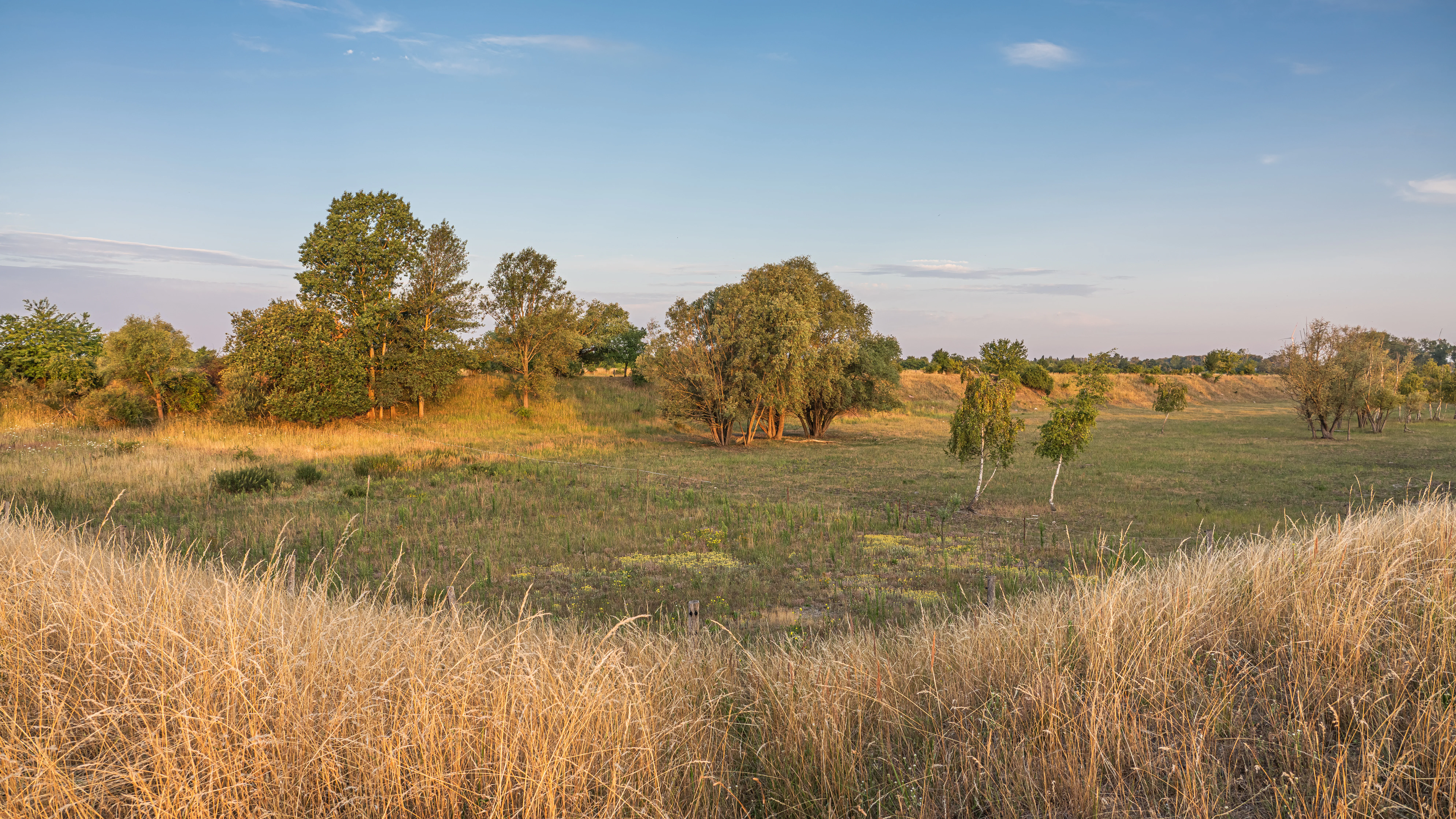
Wide view of a flat meadow with tall, golden dry grass in the foreground, scattered clusters of green trees, and low-lying shrubs under a light blue sky.
A view of the open landscape and wetland vegetation within the Falkenberger Rieselfelder nature reserve.

Falkenberger Rieselfelder history and protected-area timeline

The history of Falkenberger Rieselfelder is closely tied to the development of Berlin's late nineteenth century sanitation infrastructure. The city councillor James Hobrecht oversaw the expansion of Berlin's sewerage system and the establishment of large sewage irrigation fields, or Rieselfelder, on the city's outskirts. Beginning around 1884, these fields used natural soil processes to treat wastewater: liquid waste was distributed across sandy, nutrient-poor ground, where filtration and infiltration purified the water and the remaining sludge dried into a valuable fertilizer.

The sandy soils of the Falkenberg area proved well suited to this system, and the fields supported both wastewater management and agricultural use, especially the cultivation of grain and vegetables. Through the early twentieth century the Rieselfelder continued to function as part of Berlin's urban infrastructure.

By the 1950s and 1960s, however, it became clear that the wastewater carried increasing loads of pollutants, making the irrigation fields environmentally unsafe. In 1968 a modern sewage treatment plant was commissioned in Falkenberg, and the irrigation fields were no longer needed. Over the following decades the abandoned fields gradually returned to a semi-natural state, with the surviving basins, ditches, hedges, and embankments forming the structural backbone of today's nature reserve.

On 29 March 1995 the Falkenberger Rieselfelder were officially designated as a nature reserve, formalizing the protection of the site's ecological values. The nature reserve status was subsequently reinforced by its inclusion in the European Natura 2000 network, reflecting the site's particular importance for amphibians.

Falkenberger Rieselfelder landscape and geographic character

The landscape of Falkenberger Rieselfelder is shaped by its origins as an engineered irrigation field, and traces of that human design remain clearly visible. The terrain is flat to gently undulating, with sandy soils typical of the northern Berlin area, and the reserve is structured around a network of former irrigation and infiltration basins, drainage ditches, and field boundaries.

The Koppelgraben, a central drainage feature running roughly northwest to southeast through the reserve, divides the area into two main sections. In the northwestern part, a small patch of deciduous forest is surrounded by taller herbaceous vegetation and wetland margins, while the southeastern section contains the open meadows and grazing paddocks that dominate the character of the reserve.

The northern boundary of the reserve is marked by the administrative border with Brandenburg, while the eastern edge follows the Millionengraben, a major historical drainage channel. To the west lies a small lake area known as the Berllpfuhl, and the southern boundary runs along the Zehnrutenweg, part of the Barnimer Dörferweg hiking route. Together these features enclose a varied ecological landscape of woodland clearings, wet meadows, shallow ponds, and open pasture, all within the urban-rural transition zone on the edge of Berlin.

Falkenberger Rieselfelder ecosystems, habitats, and plant life

Ecologically, Falkenberger Rieselfelder represents a particularly valuable example of how abandoned industrial-agricultural land can evolve into a habitat-rich mosaic in a heavily urbanized context. The combination of shallow seasonal water bodies, marshy edges, tall herb vegetation, scrub, small woodland patches, and dry meadows creates a wide range of microhabitats within a small area.

The reserve's pools and depressions form the core of its ecological identity. Because water levels fluctuate strongly across the year, the wetland system includes both frequently inundated basins and drier transitional zones. Several depressions were purposefully deepened to buffer against these fluctuations, ensuring that enough water remains available during drier periods to support breeding amphibians.

The open meadows are maintained through grazing, which prevents the encroachment of shrubs and trees and preserves the open-ground character that many of the reserve's species depend on. The result is a structural patchwork that resembles, in miniature, the kind of habitat diversity typically associated with rural landscapes rather than inner-city reserves.

Falkenberger Rieselfelder wildlife and species highlights

Falkenberger Rieselfelder is most celebrated for its amphibians. The reserve hosts nine of the twelve amphibian species recorded in Berlin, a remarkable concentration for such a small protected area. Among these, the great crested newt and the fire-bellied toad are particularly important, and their presence was a key reason for the site's inclusion in the Natura 2000 network.

Other amphibians found in the area include common toads, natterjack toads, common spadefoot toads, and moor frogs, each of which benefits from the network of shallow pools, ditches, and seasonal basins maintained across the reserve. The diversity of water conditions across the site allows different species to find suitable breeding and sheltering habitat even as overall water levels shift through the seasons.

Beyond amphibians, the meadows and scrub edges support a notable community of breeding and ground-nesting birds. Species regularly associated with the reserve include the skylark, the corn bunting, the whinchat, the European stonechat, the common quail, and the northern lapwing. Raptors are also part of the fauna, with the common buzzard once again nesting locally; the Berlin Senate administration installed wooden posts to assist hunting and perching opportunities for these birds.

The grazing herd of Heck cattle itself functions as part of the wildlife story. By keeping the meadows open and creating varied vegetation structure through their movement and grazing patterns, the cattle help sustain habitat conditions for many of the smaller species that define the reserve's ecological value.

Falkenberger Rieselfelder conservation status and protection priorities

The conservation significance of Falkenberger Rieselfelder lies in its role as a refuge for biodiversity in an intensively urbanized region. Although the reserve is modest in size, its habitat diversity and species richness give it an importance that far outweighs its area. It demonstrates how relatively small, strategically protected patches can sustain viable populations of species otherwise under pressure in the surrounding landscape.

The site's formal designation in 1995 as a nature reserve under German law established a baseline of protection covering its flora, fauna, and structural elements. Its subsequent integration into the Natura 2000 network, the European Union's coordinated system of protected areas, underscores its importance at a continental scale, particularly for amphibians that are listed in the EU Habitats Directive.

Active management is a defining feature of the reserve. The grazing program using Heck cattle, an old domestic breed kept for conservation grazing purposes, prevents bush encroachment, preserves open meadow habitats, and supports the populations of ground-nesting birds and amphibians that depend on these conditions. Water management, including the deliberate deepening of selected basins, also helps maintain amphibian breeding habitat across years of variable rainfall.

In a broader sense, the reserve illustrates the value of working with the legacy of past land use. Rather than erasing the historic irrigation infrastructure, conservation efforts at Falkenberger Rieselfelder retain and adapt its features, recognizing that the very structures once built for wastewater treatment now provide some of the most important habitat on the site.

Top sights and standout views in Falkenberger Rieselfelder

Falkenberger Rieselfelder stands out as one of Berlin's most ecologically rich small reserves, combining a layered industrial-agricultural history with strong modern conservation outcomes. Its former function as a sewage irrigation field is still readable in the landscape, through the surviving basins, ditches, and embankments that now serve wildlife rather than wastewater.

The reserve's amphibians are its strongest calling card, with the presence of the great crested newt and the fire-bellied toad anchoring its Natura 2000 status. The management approach, especially the grazing of Heck cattle, is also a defining feature, demonstrating how traditional and semi-traditional livestock breeds can be used to maintain open, species-rich landscapes within a city.

For visitors, the reserve offers a quiet contrast to the dense urban fabric around it: meadows, ponds, woodland edges, and bird-rich fields where skylarks, lapwings, and corn buntings still breed. It is a place where the layered story of Berlin, from nineteenth century sanitation to twenty-first century conservation, is written directly into the land.

Best time to visit Falkenberger Rieselfelder

The character of a visit to Falkenberger Rieselfelder changes with the seasons in ways typical of wetland and meadow habitats. Spring and early summer are particularly rewarding for amphibian interest, when the reserve's pools and basins come alive with breeding frogs, toads, and newts. This period also coincides with the peak song and breeding activity of many of the meadow birds for which the area is known, including skylarks and whinchats.

Late spring and early summer also highlight the open meadow landscape, when grasses and wildflowers are at their most visually expressive and grazing Heck cattle are active across the paddocks. Summer brings warmer conditions and generally lower water levels, with the meadows taking on a drier, more steppe-like quality. Autumn and winter visits offer a quieter atmosphere and clearer views across the open landscape, though amphibian and bird activity is reduced.

Overall, the reserve most clearly expresses its ecological identity during the warmer half of the year, when water, vegetation, and breeding wildlife combine to give a strong sense of the site's habitat diversity.

Monthly climate preview

Long-term representative point measurements tracking monthly temperature and precipitation rhythm

Falkenberger Rieselfelder Climate Normals and Annual Temperature Patterns

Falkenberger Rieselfelder exhibits a measured annual temperature range from sub-zero winter minimums to warm summer maximums alongside consistent monthly precipitation rates. Reviewing the complete twelve-month profile provides deeper insight into long-term climate normals and regional weather variation across the coordinate point.
Annual mean9 °C
-1 °C20 °C
Jan-1°
Feb
Mar
Apr
May14°
Jun18°
Jul20°
Aug20°
Sep15°
Oct
Nov
Dec
Warmest month
July

20.3 °C

Coolest month
January

-0.9 °C

Wettest month
July

2.4 mm/day

Driest month
April

1.1 mm/day

Park location guide

Geography guide, regional context, and park location map for Falkenberger Rieselfelder

Falkenberger Rieselfelder park geography, regions, and map view in Germany

Understand where Falkenberger Rieselfelder sits in Germany through a broader geographic reading of the surrounding landscape, nearby location context, and its mapped position within the national park landscape.

How Falkenberger Rieselfelder fits into Germany

Germany is a federal republic in Western and Central Europe with a population of over 83 million across sixteen constituent states. It is Europe's largest economy by nominal GDP and a major global exporter and importer. The capital is Berlin, and the country borders Denmark, Poland, Czech Republic, Austria, Switzerland, France, Luxembourg, Belgium, and the Netherlands.

Wider geography shaping Falkenberger Rieselfelder in Germany

Germany is located in Western and Central Europe, spanning 357,022 km². It borders Denmark to the north, Poland and the Czech Republic to the east, Austria and Switzerland to the south, and France, Luxembourg, Belgium, and the Netherlands to the west. The country has coastlines on the Baltic Sea and North Sea to the north, with the Alps located in the southern region.

Map view of Falkenberger Rieselfelder

Use this park location map to pinpoint Falkenberger Rieselfelder in Germany, understand its exact geographic position, and read its mapped placement within the surrounding landscape more clearly.

Pigeon | © OpenStreetMap contributors

Location context for Falkenberger Rieselfelder

Berlin

Visual reference collection highlighting wetland habitats, meadows, and terrain character

Falkenberger Rieselfelder Landscape Photography and Protected Area Scenery

Falkenberger Rieselfelder photos reveal the flat terrain, shallow basins, and open pastures that define this urban nature reserve. Examining visual records helps observers understand how reclaimed irrigation infrastructure transformed into a vital wetland and amphibian habitat mosaic.

Wide view of a flat meadow with tall, golden dry grass in the foreground, scattered clusters of green trees, and low-lying shrubs under a light blue sky.

A wide, flat field in a nature reserve under a blue sky with scattered clouds, flanked by two bare trees and featuring a small wooden post with a white marker.

Park atlas

Compare nearby nature reserves and regional conservation areas across northern Berlin

Parks Near Falkenberger Rieselfelder and Surrounding Protected Landscapes

Browse other parks near Falkenberger Rieselfelder to examine similar wetland habitats and urban nature reserves. Moving across adjacent protected areas reveals broader regional geography and ecological networks within the surrounding territory.
Nature reserveBerlin
About 2.9 km away#1 closest

South

Unkenpfuhle Marzahn Nature Reserve: Geographic Context and Protected Landscape Map

Urban amphibian habitat in Berlin, Germany

Unkenpfuhle Marzahn is a protected nature reserve spanning over three hectares of glacial moraine terrain in Berlin. The site provides a critical haven for threatened amphibians, featuring a unique combination of wetland ponds, reedbeds, and dry grassland habitats tucked between urban and cemetery zones.

Area
0.033 km²
Established
2001
IUCN
IV
Scope
Terrestrial
Watercolor painting of a peaceful wetland landscape with lush green trees, reeds, and soft hills in the background under a light sky.
Nature reserveBerlin
About 3.4 km away#2 closest

West

Malchower Aue Nature Reserve: A Detailed Atlas of Urban Protected Landscapes in Berlin

Wetland habitats and glacial terrain within the Berlin city limits.

Malchower Aue stands as a protected enclave of wetland diversity featuring a system of reed-fringed peat-cutting ponds, wet meadows, and rare dry-grassland vegetation on historical soil mounds. This site provides a vital geographic perspective on how post-glacial relief and human land-use history shape protected areas within the modern urban landscape of Berlin.

Area
0.222 km²
Established
1995
Relief
Lowland
Climate
Temperate
A horizontal watercolor painting depicting a marshy landscape with ponds, green vegetation, and soft distant hills against a light background.
Nature reserveBerlin
About 6.9 km away#3 closest

Northwest

Karower Teiche Nature Reserve: Mapped Protected Wetland Geography in Northeast Berlin

Transitional lowland fen and pond mosaic

Karower Teiche protects a unique 128 hectare wetland mosaic in the Pankow district of Berlin. Centered on four shallow ponds and extensive reedbeds, the reserve maintains a vital ecological corridor between the Barnim plateau and the Berlin glacial valley. This site provides essential habitat for amphibians and reed-specialist birds within an urban setting.

Area
1.286 km²
Established
1994
IUCN
IV
Relief
Lowland
A horizontal watercolor illustration of a wetland scene with soft pink and green tones, showing sparse trees on the banks of a shallow, marshy water area under a pale sky.
Nature reserveBrandenburg
About 7.4 km away#4 closest

North

Ausstichgelände Röntgental: Brandenburg Nature Reserve and Protected Wetland Atlas

Mapped ecological landscapes on the Berlin metropolitan fringe

Investigate the detailed geography of Ausstichgelände Röntgental, a compact nature reserve in Brandenburg. Formed from nineteenth-century railway sand quarries, this protected area features a diverse mosaic of reed beds, open water, and alder carr forest. The site provides a compelling case study of post-industrial ecological recovery within the broader Barnim Nature Park landscape.

Area
0.248 km²
Established
1990
IUCN
IV
Watercolor illustration showing a soft landscape with a pond, marsh vegetation, and a background of rolling hills or meadows.
Nature reserveBerlin
About 7.4 km away#5 closest

Northwest

Mittelbruch Nature Reserve: Mapped Wetland Geography and Protected Landscape in Berlin

Examining lowland peat diggings and protected moorland ecosystems

Mittelbruch stands as a compact nature reserve in northeastern Berlin, featuring a layered landscape of former peat diggings and open moor meadows. This area plays a critical role in urban conservation by providing essential refuge for waterbirds and diverse meadow flora. Utilize the atlas to study the reserve's internal geography, including its managed reed belts and surrounding forest edges that form a distinct ecological mosaic within the city landscape.

Area
0.282 km²
Established
1997
IUCN
IV
Relief
Lowland
A watercolor illustration of a rural landscape with low hills, trees, and grassy meadow areas.
Nature reserveBrandenburg
About 8.5 km away#6 closest

North

Faule Wiesen bei Bernau Nature Reserve: Mapped Landscapes and Geography of Brandenburg

A vital Panke river corridor protecting rare meadow and woodland biomes.

Spanning 37 hectares near the northern edge of Berlin, Faule Wiesen bei Bernau offers a study in contrasting landscapes. The reserve features open wet meadows and small ponds alongside sandy dry grasslands and oak woodlands. It remains an essential ecological link within the Barnim district, preserving critical habitats for amphibians and orchids within the broader Brandenburg geography.

Area
0.37 km²
Established
2000
Relief
Lowland
Scope
Terrestrial
Watercolor painting of a rolling landscape with green grass, bushes, and soft-colored hills in the background.
Protected landscapeBerlin
About 9.2 km away#7 closest

South

Kaulsdorfer Seen: A Protected Landscape in Berlin with Glacial and Industrial History

Exploring the groundwater protection zones and post-mining lakes of eastern Berlin

The Kaulsdorfer Seen area represents a distinct protected landscape located in Berlin. It showcases the transition between ice-age glacial regions, featuring two prominent lakes that evolved from sand and gravel pits into a mature ecosystem of willow thickets, woodland, and reeds. This site functions as an important drinking-water protection zone, offering a structured look at the complex interplay between urban development and natural resource conservation.

Area
0.937 km²
Water
Major water bodies
A pale, minimalist watercolor painting depicting an open field with a winding stream, scattered trees, and distant rolling hills on a white background.
Nature reserveBerlin
About 9.7 km away#8 closest

South

Biesenhorster Sand Nature Reserve: Protected Glacial Landscape in Berlin

Urban nature reserve featuring dry grassland and rare species habitats.

Located in eastern Berlin, Biesenhorster Sand preserves a significant glacial outwash plain that supports an extraordinary concentration of rare species. This nature reserve serves as a vital ecological corridor, protecting a mosaic of dry grassland and open sand terrain that contrasts with the surrounding urban fabric of Germany's capital.

Area
0.429 km²
Established
2021
Relief
Lowland
Scope
Terrestrial

Common questions about visiting, size, designation, and location context for Falkenberger Rieselfelder

Falkenberger Rieselfelder FAQs for park facts, access, geography, and protected area context

Find quick answers about Falkenberger Rieselfelder, including protected-area facts, park geography, trail and visitor context, and how the park fits into its surrounding country and regional landscape.
MoriAtlas Explorer

Continue Your Protected Areas Search Across the Global Atlas

Deepen your exploration by continuing the structured search for national parks and protected areas worldwide. Utilize the comprehensive filtering capabilities to compare different conservation landscapes and refine your understanding of global park geography. Discover more about the distribution and characteristics of protected natural areas.

Global natural geography