
Mori Atlas logo
Nature reserveFaule Wiesen bei Bernau

Trace the Panke river corridor and its rare juxtaposition of floodplain meadows and sandy dry woodlands.

Faule Wiesen bei Bernau Nature Reserve: Protected Landscape and Geographic Mapping in Brandenburg

(Naturschutzgebiet Faule Wiesen bei Bernau)

Faule Wiesen bei Bernau serves as a critical protected corridor in the Brandenburg region, stretching along the Panke river valley between Schönow and Zepernick. This 37-hectare nature reserve creates a distinct biotope network by connecting wet meadow complexes with the contrasting dry oak woodland of the Priesterwald. Its geography provides a refuge for varied amphibians, birds, and orchids, standing as a significant example of peri-urban conservation land.

wet meadowsfloodplainPanke riveramphibiansorchidsbreeding birds
A flat-style digital illustration of a green meadow with tall grasses, wildflowers, and trees in the foreground, with rolling hills in the background under a soft pastel sky.

Faule Wiesen bei Bernau

Nature reserve

Park overview

Structured park overview, official facts, and landscape profile for Faule Wiesen bei Bernau

Faule Wiesen bei Bernau park facts, protected area profile, and essential visitor context

Review the core facts for Faule Wiesen bei Bernau, including designation, size, terrain, visitor scale, habitats, and operating context in one park-focused overview.

About Faule Wiesen bei Bernau

Faule Wiesen bei Bernau is a nature reserve on the outer edge of metropolitan Berlin, occupying a narrow but ecologically valuable strip of the Panke river valley in the district of Barnim, Brandenburg. The protected area lies within the settlement landscape of the northern Berlin outskirts, between the village of Schönow, which belongs to the town of Bernau bei Berlin, and Zepernick, a locality of the municipality of Panketal. With a size of approximately 37 hectares and a length of about one kilometer, it is a compact site, but it plays a meaningful role in the regional ecological structure.

The reserve was legally established on 3 April 2000 by statutory order of the Brandenburg Ministry for Agriculture, Environmental Protection and Spatial Planning. The protection order aims primarily to preserve and develop an extensively managed wet grassland complex together with its embedded small waters as habitat for endangered animal and plant species, especially amphibian, bird, and orchid species. Adjacent green areas on the edges of these sensitive wet zones were also placed under protection, functioning as buffer zones between the reserve and the surrounding settlements of Schönow and Zepernick.

A second important element of the site is found in its northwestern part, where sandy dry grassland and dry oak woodland communities of the Priesterwald support typical site-specific biotopes and species assemblages. This combination of floodplain wet habitats and dry sandy woodland within a single small reserve is a defining feature of the area.

The site is a key component of a larger biotope network along the Panke that crosses the Berlin Brandenburg state boundary. This network also includes the Ausstichgelände Röntgental, Mittelbruch in Berlin Buch, the Bogenseekette and Lietzengrabenniederung, and the Karower Teiche reserves. Together, these areas form a coherent ecological corridor for wetland dependent species in the densely populated outer Berlin region.

Quick facts and research context for Faule Wiesen bei Bernau

Faule Wiesen bei Bernau is a nature reserve (Naturschutzgebiet) of around 37 hectares in the northern Berlin periphery, within the district of Barnim, Brandenburg. It lies along the Panke between Schönow (Bernau bei Berlin) and Zepernick (Panketal), bordering residential areas to the north and west and the Berlin Szczecin railway line to the south. Protection was decreed on 3 April 2000 by the Brandenburg Ministry for Agriculture, Environmental Protection and Spatial Planning. The reserve combines wet meadows, small ponds, sandy dry grassland (Sandtrockenrasen), and dry oak woodland (Trockeneichenwald). It is part of a biotope network along the Panke that also includes the Ausstichgelände Röntgental, Mittelbruch, Bogenseekette and Lietzengrabenniederung, and the Karower Teiche nature reserves.

Protection and recognition

Explore documented terrestrial protection history and formal designation year records.

Faule Wiesen bei Bernau Protection Status and Designated Area Records

Faule Wiesen bei Bernau maintains a recorded terrestrial protection scope established in the year 2000. Comprehensive conservation data details the official designation timeline and management framework without international recognition sources.

Protection details

Protection scope
Terrestrial
Designated year
2000
Transboundary protection
No
Park context

Deeper park guide and search-rich context for Faule Wiesen bei Bernau

Faule Wiesen bei Bernau history, landscape, wildlife, and travel context

Explore Faule Wiesen bei Bernau through its history, landscape character, ecosystems, wildlife, conservation priorities, cultural context, and seasonal travel timing in a structured park guide built for atlas discovery and search intent.

Why Faule Wiesen bei Bernau stands out

Faule Wiesen bei Bernau is best known for protecting a rare, extensively used wet meadow complex along the Panke river, including small ponds that serve as important habitat for threatened amphibians, breeding birds, and wild orchids. The reserve also stands out for containing an unusually close combination of two contrasting habitat types: damp, species-rich floodplain meadows on one side and dry, sandy grassland with associated dry oak woodland of the Priesterwald on the other. This juxtaposition of wet and dry habitats within a small area gives the site a distinctive ecological character for a peri-urban reserve.
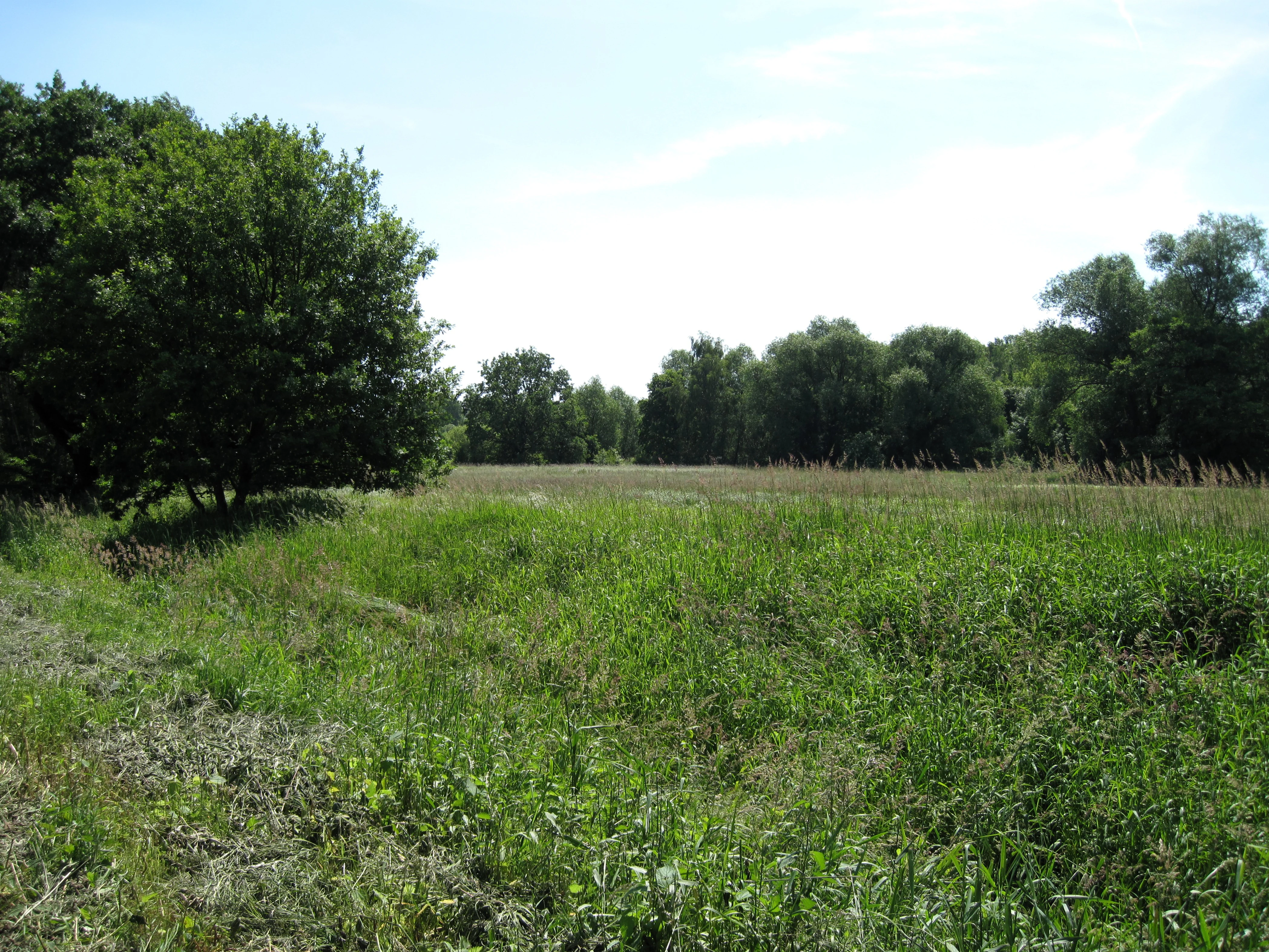
A view of a grassy meadow with a large tree in the foreground and a dense line of trees in the background under a blue sky.
The landscape along the Panke stream near the Faule Wiesen bei Bernau nature reserve.

Faule Wiesen bei Bernau history and protected-area timeline

The area now designated as Faule Wiesen bei Bernau was placed under legal protection on 3 April 2000 by order of the Brandenburg Ministry for Agriculture, Environmental Protection and Spatial Planning. The protection order formalized the conservation status of a roughly 37 hectare landscape along the Panke and recognized both the wet meadow complex and the dry sandy woodland of the Priesterwald as worthy of lasting preservation.

The reservation was driven primarily by the ecological value of the extensively used wet meadows and their importance as habitat for threatened amphibians, breeding birds, and orchid species. The inclusion of surrounding green areas as buffer zones between the reserve and the adjacent villages of Schönow and Zepernick reflected an awareness that conservation in this location could only succeed if the surrounding settlement pressure was explicitly addressed in the designation.

Since its establishment, the reserve has faced ongoing management pressures from its location. Continued illegal dumping of household and garden waste along footpaths crossing the site has required repeated volunteer clean ups, and authorities have recognized that such cleanup actions need to be complemented by preventive measures and regular monitoring to ensure the long-term integrity of the protection order.

Faule Wiesen bei Bernau landscape and geographic character

The landscape of Faule Wiesen bei Bernau is shaped by the shallow valley of the Panke river, along which the reserve extends for roughly one kilometer. The protected strip follows the river on both sides and forms a green corridor between the built up areas of Schönow to the north and Zepernick to the west, with the railway line between Berlin and Szczecin marking its southern edge.

Within this corridor, the western part of the reserve, around the Priesterwald area, displays a clearly different landscape character. Sandy dry grassland (Sandtrockenrasen) opens up into dry oak woodland communities (Trockeneichenwald), both shaped by the dry, nutrient poor soils typical of this part of the Barnim plateau. These dry, open and lightly wooded areas contrast sharply with the wet meadows and small ponds nearer the Panke.

Along the river itself, the terrain is dominated by open, low-lying wet meadows interspersed with small standing water bodies. Local streets including An der Panke, Weidenweg, Karvendelweg and Waldstraße mark the northern and northeastern edge of the reserve, and several footpaths cross the area, including a well used walking connection between Zepernick and Schönow.

Faule Wiesen bei Bernau ecosystems, habitats, and plant life

The ecological character of Faule Wiesen bei Bernau is defined by the contrast between a floodplain wetland system and a small area of dry sandy woodland, packed into a relatively small protected area of around 37 hectares.

The central and eastern sections consist of an extensively used wet meadow complex with embedded small ponds and water bodies within the floodplain of the Panke. These damp, open habitats support rich herbaceous vegetation and provide breeding grounds for a range of water associated animal species. The mosaic of meadows, seasonal wet zones, and standing waters is the core of the reserve's ecological value.

In the northwestern part of the reserve, the vegetation shifts to dry sandy grassland and dry oak woodland of the Priesterwald. These habitats are typical of the glacial outwash and moraine soils of the area and carry their own characteristic plant and animal communities. The proximity of contrasting wet and dry habitat types within a single small protected area gives the site a noticeable ecological diversity that would not be expected from its size alone.

Faule Wiesen bei Bernau wildlife and species highlights

The wildlife significance of Faule Wiesen bei Bernau is closely linked to its wet meadows, small ponds, and the surrounding buffer zones. The reserve's protection order explicitly identifies amphibian species, breeding bird species, and orchid species as key groups for which the site provides important habitat.

The ponds and wet depressions scattered through the meadow complex are particularly important for amphibians, while the open wet meadows and tall herb vegetation support characteristic breeding birds of floodplain and meadow habitats in the Brandenburg countryside. The site's location along the Panke further enhances its value as a dispersal and feeding corridor for water associated wildlife in the Berlin outskirts.

On the dry side, the sandy grassland and dry oak woodland in the northwestern part of the reserve harbor different but equally characteristic fauna, typical of the open and lightly wooded dry landscapes of the region. The combination of habitats makes the reserve a small but relatively diverse refuge in a densely populated peri-urban setting.

Faule Wiesen bei Bernau conservation status and protection priorities

Faule Wiesen bei Bernau is protected as a nature reserve (Naturschutzgebiet) under Brandenburg law, with the original protection order issued on 3 April 2000 by the Brandenburg Ministry for Agriculture, Environmental Protection and Spatial Planning. The legal designation binds the area to defined conservation objectives aimed at preserving and developing the wet meadows, small ponds, and dry sandy woodland habitats and their associated species.

The specific conservation goals include safeguarding the extensively used wet grassland complex and its embedded ponds as habitat for threatened amphibians, birds, and orchids, and maintaining the dry sandy grassland and dry oak woodland communities of the Priesterwald with their typical species composition. Green areas bordering the sensitive wetlands were integrated into the reserve as buffer zones against the influence of the surrounding settlements.

At a landscape scale, the reserve is part of an inter-state biotope network along the Panke, connecting to the Ausstichgelände Röntgental, Mittelbruch in Berlin Buch, the Bogenseekette and Lietzengrabenniederung, and the Karower Teiche. This networked role increases its conservation value, as small protected sites only fully realize their function when linked to other habitats along ecological corridors.

A real conservation challenge for the site has been the ongoing illegal dumping of household and garden waste, especially along the footpaths crossing the reserve. Volunteer cleanup actions have helped mitigate the problem, but the protection order itself identifies the need for preventive measures and continued monitoring by the responsible authorities to secure long-term conservation success.

Faule Wiesen bei Bernau cultural meaning and human context

Although Faule Wiesen bei Bernau is primarily valued as a natural area, the reserve is situated at the seam between historic rural villages and the rapidly expanding outer Berlin settlement landscape. Its location between Schönow, part of the old town of Bernau bei Berlin, and Zepernick, within the municipality of Panketal, places it directly within a long-established cultural landscape that has increasingly been shaped by suburban growth and transport infrastructure such as the Berlin Szczecin railway.

The network of local streets such as An der Panke, Weidenweg, Karvendelweg, and Waldstraße, along with the footpaths crossing the area, reflect a long tradition of everyday local movement between the villages. Today the well used footpath between Zepernick and Schönow illustrates how the reserve, despite its protected status, remains closely interwoven with daily life in the surrounding communities.

Top sights and standout views in Faule Wiesen bei Bernau

Faule Wiesen bei Bernau combines within a compact 37 hectare area a floodplain wet meadow complex with small ponds and a contrasting dry sandy oak woodland of the Priesterwald. This juxtaposition of wet and dry habitats gives the site an unusually high ecological diversity for its size and makes it especially valuable as a refuge for amphibians, breeding birds, and wild orchids.

The reserve is a key part of the cross-border Panke biotope network linking multiple nature reserves in the northern Berlin outskirts, and as such plays an important role in maintaining ecological connectivity in an otherwise heavily urbanized region. Its proximity to the settlements of Schönow and Zepernick both shapes its conservation challenges, such as littering along footpaths, and its value as a nearby green space for local communities.

Best time to visit Faule Wiesen bei Bernau

Spring and early summer are particularly rewarding times to experience Faule Wiesen bei Bernau, when wet meadows along the Panke support a wide range of flowering plants, amphibians are active in and around the small ponds, and breeding bird activity in the open floodplain landscape is at its height. Late spring is also typically when orchid species in the reserve become visible in the meadows and along the marshy edges.

Mornings and evenings generally offer the richest wildlife observations, especially for amphibians and birds, while any visit in daylight allows clear views of the contrast between the wet Panke valley meadows and the dry sandy oak woodland of the Priesterwald. Because the reserve lies within a peri-urban setting and is freely accessible, visitors should also expect to encounter local walkers on the footpaths that cross the area.

Monthly climate preview

Long-term representative records of monthly temperature and precipitation rhythm

Faule Wiesen bei Bernau Climate and Annual Temperature Normals Preview

Representative point measurements for Faule Wiesen bei Bernau establish a measured annual cycle ranging from sub-zero winter lows to warm summer maximums alongside stable daily precipitation. Exploring the complete twelve-month climatology reveals detailed temperature spreads and monthly precipitation normals across the protected landscape.
Annual mean9 °C
-1 °C20 °C
Jan-1°
Feb
Mar
Apr
May14°
Jun18°
Jul20°
Aug20°
Sep15°
Oct
Nov
Dec
Warmest month
July

20.3 °C

Coolest month
January

-0.9 °C

Wettest month
July

2.4 mm/day

Driest month
April

1.1 mm/day

Park location guide

Geography guide, regional context, and park location map for Faule Wiesen bei Bernau

Faule Wiesen bei Bernau park geography, regions, and map view in Germany

Understand where Faule Wiesen bei Bernau sits in Germany through a broader geographic reading of the surrounding landscape, nearby location context, and its mapped position within the national park landscape.

How Faule Wiesen bei Bernau fits into Germany

Germany is a federal republic in Western and Central Europe with a population of over 83 million across sixteen constituent states. It is Europe's largest economy by nominal GDP and a major global exporter and importer. The capital is Berlin, and the country borders Denmark, Poland, Czech Republic, Austria, Switzerland, France, Luxembourg, Belgium, and the Netherlands.

Wider geography shaping Faule Wiesen bei Bernau in Germany

Germany is located in Western and Central Europe, spanning 357,022 km². It borders Denmark to the north, Poland and the Czech Republic to the east, Austria and Switzerland to the south, and France, Luxembourg, Belgium, and the Netherlands to the west. The country has coastlines on the Baltic Sea and North Sea to the north, with the Alps located in the southern region.

Map view of Faule Wiesen bei Bernau

Use this park location map to pinpoint Faule Wiesen bei Bernau in Germany, understand its exact geographic position, and read its mapped placement within the surrounding landscape more clearly.

Pigeon | © OpenStreetMap contributors

Location context for Faule Wiesen bei Bernau

Brandenburg

Visualizing the rare wet meadows and dry oak woodland of the Panke river corridor

Faule Wiesen bei Bernau Photos: Exploring Landscapes, Scenery, and Habitats

Visual documentation captures the contrasting terrain of damp floodplain meadows and sandy dry grassland across the protected Priesterwald area. Studying these habitat views reveals the distinctive ecological character and protected landscape features of the reserve.

A view of a grassy meadow with a large tree in the foreground and a dense line of trees in the background under a blue sky.

Park atlas

Compare regional nature reserves and connected Panke corridor habitats

Explore Protected Areas and Parks Near Faule Wiesen bei Bernau

Browsing other protected areas near Faule Wiesen bei Bernau reveals broader ecological connectivity across the Barnim plateau. Comparing adjacent river valleys and woodland reserves helps trace regional biodiversity patterns beyond single nature sites.
A horizontal watercolor illustration showing a pinkish-purple foreground of heathland vegetation transitioning into a line of light green trees against a pale, washed-out hilly background.
Nature reserveBrandenburg
About 1.9 km away#1 closest

Northwest

Schönower Heide Nature Reserve: An Atlas View of Brandenburg Protected Heathlands

A restored landscape of glacial dunes and sandy heath

Schönower Heide stands as a significant nature reserve in Brandenburg, Germany. The area protects a unique combination of open sand heath, pine woodland, and wetland meadows formed on post-glacial outwash plains. This protected landscape is recognized for its successful transition from former military terrain into a vibrant habitat for diverse flora and fauna, including managed populations of red deer and mouflon within its fenced boundaries.

Area
5.334 km²
Established
2000
IUCN
V
Relief
Lowland
A horizontal watercolor illustration of a wetland scene with soft pink and green tones, showing sparse trees on the banks of a shallow, marshy water area under a pale sky.
Nature reserveBrandenburg
About 2.6 km away#2 closest

Southwest

Ausstichgelände Röntgental: Brandenburg Nature Reserve and Protected Wetland Atlas

Mapped ecological landscapes on the Berlin metropolitan fringe

Investigate the detailed geography of Ausstichgelände Röntgental, a compact nature reserve in Brandenburg. Formed from nineteenth-century railway sand quarries, this protected area features a diverse mosaic of reed beds, open water, and alder carr forest. The site provides a compelling case study of post-industrial ecological recovery within the broader Barnim Nature Park landscape.

Area
0.248 km²
Established
1990
IUCN
IV
Watercolor illustration showing a soft landscape with a pond, marsh vegetation, and a background of rolling hills or meadows.
Nature reserveBerlin
About 3.5 km away#3 closest

Southwest

Mittelbruch Nature Reserve: Mapped Wetland Geography and Protected Landscape in Berlin

Examining lowland peat diggings and protected moorland ecosystems

Mittelbruch stands as a compact nature reserve in northeastern Berlin, featuring a layered landscape of former peat diggings and open moor meadows. This area plays a critical role in urban conservation by providing essential refuge for waterbirds and diverse meadow flora. Utilize the atlas to study the reserve's internal geography, including its managed reed belts and surrounding forest edges that form a distinct ecological mosaic within the city landscape.

Area
0.282 km²
Established
1997
IUCN
IV
Relief
Lowland
A watercolor painting of a serene fen or wetland with reeds in the foreground, calm water, and rolling hills in the background under a soft pastel sky.
Nature reserveBarnim District
About 4.6 km away#4 closest

Northeast

Ladeburger Schaeferpfuhle: Nature Reserve and Protected Landscape in Barnim District

Mapped lowland fen ecosystems and habitat geography

Located in the Barnim District of Germany, Ladeburger Schaeferpfuhle is a designated nature reserve defined by its post-glacial lowland fen terrain. This area preserves a mosaic of wet meadows, shrub thickets, and pools that support specialized plant and wildlife populations. The site serves as a vital example of regional hydrology, maintaining open landscapes through traditional grazing practices that protect this fragile habitat.

Area
0.267 km²
Established
2000
Relief
Lowland
Climate
Temperate
A horizontal watercolor painting depicting a marshy landscape with ponds, green vegetation, and soft distant hills against a light background.
Nature reserveBerlin
About 7.2 km away#5 closest

Southwest

Karower Teiche Nature Reserve: Mapped Protected Wetland Geography in Northeast Berlin

Transitional lowland fen and pond mosaic

Karower Teiche protects a unique 128 hectare wetland mosaic in the Pankow district of Berlin. Centered on four shallow ponds and extensive reedbeds, the reserve maintains a vital ecological corridor between the Barnim plateau and the Berlin glacial valley. This site provides essential habitat for amphibians and reed-specialist birds within an urban setting.

Area
1.286 km²
Established
1994
IUCN
IV
Relief
Lowland
A watercolor painting of a flat, marshy landscape with soft green trees in the midground and pale hills under a light sky in the background.
Nature reserveBerlin
About 8.5 km away#6 closest

South

Falkenberger Rieselfelder Nature Reserve: A Detailed Atlas of Berlin Protected Lands

Reclaimed wetland geography and urban conservation habitats

Falkenberger Rieselfelder acts as an ecologically rich refuge where former industrial irrigation fields have been repurposed into a mosaic of seasonal pools and meadows. Located on the urban fringe of Berlin, this nature reserve offers a unique look at how conservation grazing and habitat management support species like the great crested newt within a dense metropolitan region.

Area
0.881 km²
Established
1995
IUCN
IV
Relief
Lowland
A soft watercolor painting featuring green grasses in the foreground, calm water, and a tree line along the horizon.
Nature reserveBrandenburg
About 9.3 km away#7 closest

West

Schönerlinder Teiche Nature Reserve in Brandenburg: Protected Landscape and Geographic Atlas

Explore the wetland mosaic, bird-rich ponds, and grazing conservation areas

Schönerlinder Teiche offers a rare look at post-agricultural land transformation, featuring ponds, meadows, and reed habitats in the Brandenburg region. This nature reserve serves as an essential bird sanctuary and educational site, with water buffalo and Konik horses contributing to ongoing habitat maintenance. View the detailed geography of this protected area and its role within the wider Barnim Nature Park network.

Area
0.408 km²
Established
1997
IUCN
IV
Relief
Lowland
Watercolor painting of a peaceful wetland landscape with lush green trees, reeds, and soft hills in the background under a light sky.
Nature reserveBerlin
About 9.9 km away#8 closest

South

Malchower Aue Nature Reserve: A Detailed Atlas of Urban Protected Landscapes in Berlin

Wetland habitats and glacial terrain within the Berlin city limits.

Malchower Aue stands as a protected enclave of wetland diversity featuring a system of reed-fringed peat-cutting ponds, wet meadows, and rare dry-grassland vegetation on historical soil mounds. This site provides a vital geographic perspective on how post-glacial relief and human land-use history shape protected areas within the modern urban landscape of Berlin.

Area
0.222 km²
Established
1995
Relief
Lowland
Climate
Temperate

Common questions about visiting, size, designation, and location context for Faule Wiesen bei Bernau

Faule Wiesen bei Bernau FAQs for park facts, access, geography, and protected area context

Find quick answers about Faule Wiesen bei Bernau, including protected-area facts, park geography, trail and visitor context, and how the park fits into its surrounding country and regional landscape.
MoriAtlas Explorer

Continue Your Protected Areas Search Across the Global Atlas

Deepen your exploration by continuing the structured search for national parks and protected areas worldwide. Utilize the comprehensive filtering capabilities to compare different conservation landscapes and refine your understanding of global park geography. Discover more about the distribution and characteristics of protected natural areas.

Global natural geography