
Mori Atlas logo
Nature reserveFehmarnbelt

A deep dive into the hydrographic trench, boulder reefs, and protected benthic ecosystems of the Baltic Sea

Fehmarnbelt Nature Reserve: Exploring the Marine Geography and Submerged Landscapes of Germany

Fehmarnbelt serves as a vital marine protected area within the German exclusive economic zone, encompassing a deep submarine channel that facilitates the primary water exchange between the North Sea and the Baltic. This reserve protects a complex underwater terrain defined by shifting sandbanks, massive megaripple bedforms, and boulder reefs that rise from the seafloor. As a critical corridor for harbor porpoises, the area represents a key site for regional marine conservation and scientific study of sublittoral habitats.

marine reserveBaltic Seamarine protected areaharbor porpoiseboulder reefssandbanks
A stylized flat-design illustration of a winding river flowing through a coniferous forest beneath mountain peaks and a waterfall.

Fehmarnbelt

Nature reserve

Park overview

Structured park overview, official facts, and landscape profile for Fehmarnbelt Nature Reserve

Fehmarnbelt Nature Reserve park facts, protected area profile, and essential visitor context

Review the core facts for Fehmarnbelt Nature Reserve, including designation, size, terrain, visitor scale, habitats, and operating context in one park-focused overview.

About Fehmarnbelt Nature Reserve

Fehmarnbelt is a federally managed marine protected area lying in the waters north of the German Baltic island of Fehmarn, where the Fehmarn Belt connects the western Baltic Sea to the Great Belt and onward to the North Sea. Although it does not cover land and is not a park in the terrestrial sense, it is classified as a nature reserve of national significance and operates under the same institutional and legal framework as terrestrial German nature reserves.

The protected area sits within the German exclusive economic zone and occupies a hydrologically pivotal corridor. Roughly seventy percent of the long-term water exchange between the saline North Sea and the lower-salinity Baltic flows through the Fehmarn Belt, creating conditions that mix marine and brackish influences in a single constrained channel. This dynamic setting shapes both the seabed and the biological communities that the reserve is designed to protect.

The reserve is significant because it safeguards features that are genuinely rare in the Baltic Sea. Its southern part is characterized by large submarine sand ripples, including so-called megaripples with crest heights of several meters. These structures contain the FFH habitat type of sublittoral sandbanks and host specialized benthic communities adapted to constantly shifting sediments. The reserve also contains boulder reefs colonized by brown and red algae, sponges, and shellfish down to depths beyond twenty meters, producing one of the more species-rich underwater landscapes in the German Baltic.

Fehmarnbelt is jointly administered as a German nature reserve and as a European Habitats Directive (FFH) site, with the Federal Agency for Nature Conservation acting as the competent authority and coordinating with research institutions such as the Research and Technology Centre West Coast and the University of Kiel. The dual designation connects its national importance with broader EU marine biodiversity policy, while ongoing acoustic monitoring through porpoise click detectors and aerial surveys helps track its most sensitive species.

Quick facts and research context for Fehmarnbelt Nature Reserve

Fehmarnbelt is a marine protected area in the German exclusive economic zone of the western Baltic Sea, located north of the island of Fehmarn. It functions simultaneously as a German Naturschutzgebiet and as an EU Habitats Directive (FFH) site reported by the Federal Agency for Nature Conservation.

The reserve protects a submerged strait that channels a large share of the water exchange between the North Sea and the Baltic, alongside rare sandbank bedforms, boulder reefs, and species-rich benthic habitats. The harbor porpoise is the keystone species that gives the site its primary conservation identity.

Protection and recognition

Explore documented marine conservation scope and recognition history for Fehmarnbelt.

Fehmarnbelt Protection Status and Marine Designated Area Records

Fehmarnbelt encompasses specialized marine protection frameworks and documented conservation boundaries within its regional waters. Researching official designation parameters helps clarify the regulatory scope and environmental management context governing the marine ecosystem.

Protection details

Protection scope
Marine
Transboundary protection
No
Park context

Deeper park guide and search-rich context for Fehmarnbelt Nature Reserve

Fehmarnbelt Nature Reserve history, landscape, wildlife, and travel context

Explore Fehmarnbelt Nature Reserve through its history, landscape character, ecosystems, wildlife, conservation priorities, cultural context, and seasonal travel timing in a structured park guide built for atlas discovery and search intent.

Why Fehmarnbelt Nature Reserve stands out

Fehmarnbelt is known for protecting the Fehmarnbelt trench, a submerged channel up to about 35 meters deep that handles the majority of water exchange between the North Sea and the Baltic Sea. This strong current creates unusual ecological conditions for the western Baltic, supporting dynamic sandbank systems, large megaripple formations, and boulder reef habitats that are rare in the region. The reserve is also known as one of the most important harbor porpoise habitats in the German Baltic, with the marine mammals regularly moving through the strait and using surrounding waters around Fehmarn for resting and feeding. The combination of a high-energy hydrological setting and a fragile, species-rich marine community gives Fehmarnbelt a focused identity as both a hydrographic and a marine biodiversity hotspot.
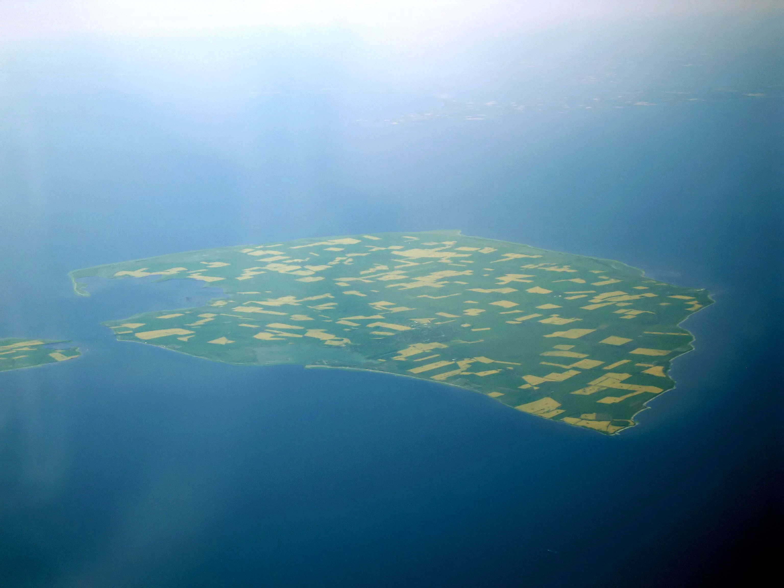
An aerial photograph of the island of Fehmarn, showing a flat, green landscape divided into small agricultural fields, entirely surrounded by the dark blue waters of the Baltic Sea.
An aerial view of the island of Fehmarn, surrounded by the Baltic Sea.

Fehmarnbelt Nature Reserve history and protected-area timeline

Fehmarnbelt emerged as a protected area in two distinct stages. In 2006, the Federal Agency for Nature Conservation reported the site to Brussels together with four other German marine conservation areas as a Special Area of Conservation under the EU Habitats Directive. This designation followed extensive baseline research on the benthos, geology, flora, fauna, and hydrology of the strait, including salinity patterns and current flows.

The national nature reserve designation was added in September 2017, formally recognizing the site under German federal nature protection law and consolidating its already established FFH status. The Bundesamt für Naturschutz remains the responsible federal authority and coordinates monitoring and research partnerships with institutions such as the Research and Technology Centre West Coast and the University of Kiel.

The reserve's history is also shaped by conflict and controversy. Since 2008, preparations for a fixed crossing of the Fehmarn Belt have raised concerns about seabed surveys and construction impacts on the protected area. In 2008, conservation groups protested seismic surveys using Sparker equipment that produced loud underwater sound pulses, with documented porpoise behavioral reactions observed as far away as Denmark. In August 2019, the detonation of British sea mines by the German Navy became another flashpoint, with environmental groups attributing porpoise deaths to the operation. These episodes have made Fehmarnbelt an important reference case in debates about balancing large infrastructure and defense projects with marine conservation in the Baltic Sea.

Fehmarnbelt Nature Reserve landscape and geographic character

The protected area consists entirely of marine landscape north of Fehmarn, but it is far from featureless. The dominant physical structure is the Fehmarnbelt trench, a submarine channel reaching depths of roughly 35 meters that funnels water between the North Sea and the Baltic. Current-driven sand movement and the funnel shape of the strait shape the seabed into dynamic bedforms that change over time.

In the southern part of the area, the seabed displays unusually large sand ripples, including megaripples with crest heights up to about 3 meters. These bedforms are not only dramatic in scale for the Baltic region but also scientifically interesting because their exact origin is not yet fully understood. Their shifting sands make them a distinctive example of the sublittoral sandbank habitat type recognized under the EU Habitats Directive.

The reserve also includes boulder reefs that rise from the surrounding sandy seabed and create three-dimensional underwater structure down to depths of more than 20 meters. These reefs form a contrast to the open sand habitats and contribute to the visual and ecological diversity of the protected area, providing hard substrate for algae and invertebrates in an otherwise soft-sediment dominated sea floor.

Fehmarnbelt Nature Reserve ecosystems, habitats, and plant life

Fehmarnbelt protects a mosaic of marine habitats typical of the transition zone between the North Sea and the Baltic. The most ecologically distinctive elements are the large sandbank systems with megaripple bedforms in the south and the boulder reefs that punctuate the central strait. Together, these habitats support one of the more biodiversity-rich underwater environments in the German Baltic.

The reefs are colonized by extensive brown and red algae communities that extend into relatively deep water for the Baltic and form the structural backbone of the reef ecosystem. On the reef surfaces, dense benthic communities develop, dominated by sponges and various bivalve species. Sensitive crustaceans and long-lived gastropods such as whelks and common spindle snails are also characteristic, indicating stable environmental conditions.

The shifting sand areas host their own specialized fauna. Communities on the megaripples show fine-scale heterogeneity, with characteristic bivalves such as Astarte clams and Iceland cyprine clams (Arctica islandica) adapted to the dynamic sedimentary environment. Researchers have documented the return of several benthic species that had not been recorded in the Baltic for years or even decades, and a significant share of the species listed as threatened in the German Baltic Red List have been found within the protected area.

Fehmarnbelt Nature Reserve wildlife and species highlights

The most visible and most important animal in Fehmarnbelt is the harbor porpoise, which is the keystone species that gives the site its primary conservation designation. Porpoises pass through the Fehmarn Belt regularly during their migrations and appear unusually frequently by Baltic standards. They use the reserve and the surrounding waters around western and southwestern Fehmarn as feeding and resting habitat, and calves have been documented within the protected area.

Porpoise presence in the reserve has been monitored since 2002 using aerial surveys conducted by the Research and Technology Centre West Coast and passive acoustic monitoring through Porpoise Click Detectors anchored around Fehmarn. Danish researchers have also tracked porpoise movements into the Fehmarn Belt, confirming the strait's role as a regional movement corridor.

The reserve also supports the small resident population of harbor seals in the southern Baltic, which use the area for foraging. While less prominent than the porpoises, the seals are recognized as an Annex II species under the Habitats Directive and benefit from the same protection framework. Beyond these charismatic marine mammals, the area supports species-rich invertebrate communities across both reef and sandbank habitats, including sponges, bivalves, crustaceans, and long-lived snails that collectively indicate a healthy and functioning benthic ecosystem.

Fehmarnbelt Nature Reserve conservation status and protection priorities

Fehmarnbelt is one of the few marine protected areas in the German Baltic with both national and European legal status. Its national protection was strengthened in September 2017 when it was formally designated as a nature reserve, on top of its earlier recognition since 2006 as a Special Area of Conservation under the EU Habitats Directive. This dual designation reflects the site's geological, ecological, and hydrological importance in a regional sea that is otherwise heavily affected by human activity.

The conservation logic of the area centers on three components. The first is hydrological: roughly seventy percent of North Sea to Baltic water exchange passes through the Fehmarn Belt, making the strait a critical control point for salinity, oxygen, and species dispersal. The second is geomorphological and habitat-based: megaripple sandbanks and boulder reefs are rare in the Baltic and represent protected habitat types under the FFH Directive. The third is faunal, anchored by the harbor porpoise, an Annex II species whose long-term survival in the German Baltic depends on quiet, intact habitats like this one.

Management is led by the Federal Agency for Nature Conservation, with strong involvement of applied research institutions including the Research and Technology Centre West Coast and the University of Kiel. Long-term acoustic and aerial monitoring of porpoises, combined with benthic surveys, has produced one of the best-documented marine datasets in the German Baltic. At the same time, the reserve faces ongoing conservation pressure from planned infrastructure projects such as the fixed Fehmarn Belt crossing and from incidental events such as the 2019 sea mine disposal operations, both of which have highlighted the tension between human use of the strait and protection of its marine life.

Fehmarnbelt Nature Reserve cultural meaning and human context

Fehmarnbelt does not have a strongly developed onshore cultural identity of its own because it is a marine reserve, but it is closely linked to the maritime culture of the island of Fehmarn and to broader debates about the future of the western Baltic. The strait has long been a busy shipping route between Germany and Denmark, and the idea of a fixed crossing has shaped regional identity, environmental politics, and cross-border relations for more than a decade.

The reserve has also become a focal point for German marine conservation organizations, including NABU and groups focused on dolphins and marine mammals. Their engagement with the site, particularly in response to seismic surveys and the 2019 sea mine clearance, has helped establish Fehmarnbelt as a touchstone case in German debates over how to protect marine mammals while accommodating infrastructure and defense activities in shared Sea waters.

Top sights and standout views in Fehmarnbelt Nature Reserve

Fehmarnbelt's standout features include the Fehmarnbelt trench itself, a 35-meter-deep channel that handles most of the water exchange between the North Sea and the Baltic, and the rare megaripple sandbanks in the southern part of the reserve, which host specialized benthic communities adapted to shifting sediments. The boulder reefs, with their deep-reaching brown and red algae forests and dense sponge and shellfish assemblages, add a contrasting hard-substrate dimension unusual in this part of the Baltic.

Equally important is the site's significance as a harbor porpoise habitat, supported by long-term aerial and acoustic monitoring. Combined with its dual status under German and EU nature protection law, these elements make Fehmarnbelt a compact but unusually rich marine conservation site in the western Baltic Sea.

Best time to visit Fehmarnbelt Nature Reserve

Views of the Fehmarnbelt nature reserve are typically experienced from the shoreline of Fehmarn or from boats operating in calm coastal conditions, since the protected area itself lies offshore. The calmer late spring and summer months generally offer the best conditions for wildlife-watching boat trips and coastal observation, when porpoises are more often visible near the surface and the Baltic weather tends to be more settled.

Winter and early spring bring stronger winds and rougher conditions, but they are also periods when migratory marine mammal activity can be high. Because the reserve's value depends on quiet underwater conditions, visitors interested in the conservation context of the site will find quieter shoulder seasons useful for reflecting on the area's marine character without the heavier recreational traffic of mid-summer.
Monthly climate preview

Long-term monthly precipitation totals and temperature ranges across the coordinate

Fehmarnbelt Climate Normals and Representative Annual Temperature Patterns

Representative baseline coordinates record monthly temperature variations alongside steady precipitation averages throughout the year. Reviewing the complete twelve-month sequence helps analyze long-term climate behavior and seasonal temperature progression across the terrain.
Annual mean9 °C
1 °C18 °C
Jan
Feb
Mar
Apr
May12°
Jun15°
Jul18°
Aug18°
Sep15°
Oct11°
Nov
Dec
Warmest month
August

18.3 °C

Coolest month
February

1.4 °C

Wettest month
August

2.3 mm/day

Driest month
April

1.2 mm/day

Park location guide

Geography guide, regional context, and park location map for Fehmarnbelt Nature Reserve

Fehmarnbelt Nature Reserve park geography, regions, and map view in Germany

Understand where Fehmarnbelt Nature Reserve sits in Germany through a broader geographic reading of the surrounding landscape, nearby location context, and its mapped position within the national park landscape.

How Fehmarnbelt Nature Reserve fits into Germany

Germany is a federal republic in Western and Central Europe with a population of over 83 million across sixteen constituent states. It is Europe's largest economy by nominal GDP and a major global exporter and importer. The capital is Berlin, and the country borders Denmark, Poland, Czech Republic, Austria, Switzerland, France, Luxembourg, Belgium, and the Netherlands.

Wider geography shaping Fehmarnbelt Nature Reserve in Germany

Germany is located in Western and Central Europe, spanning 357,022 km². It borders Denmark to the north, Poland and the Czech Republic to the east, Austria and Switzerland to the south, and France, Luxembourg, Belgium, and the Netherlands to the west. The country has coastlines on the Baltic Sea and North Sea to the north, with the Alps located in the southern region.

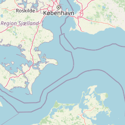
Map view of Fehmarnbelt Nature Reserve

Use this park location map to pinpoint Fehmarnbelt Nature Reserve in Germany, understand its exact geographic position, and read its mapped placement within the surrounding landscape more clearly.

Pigeon | © OpenStreetMap contributors

Explore underwater habitats, megaripple sandbanks, and marine reserve scenery in the Baltic Sea.

Fehmarnbelt Photos and Marine Landscapes: Visualizing the Protected Baltic Trench

Visual records capture the complex underwater terrain of Fehmarnbelt, highlighting rare boulder reefs and dynamic sandbank formations across the protected marine channel. Examining these protected area views provides deeper insight into the delicate ecological habitats and hydrographic conditions shaping the western Baltic environment.

An aerial photograph of the island of Fehmarn, showing a flat, green landscape divided into small agricultural fields, entirely surrounded by the dark blue waters of the Baltic Sea.

Park atlas

Compare nearby marine reserves, coastal habitats, and regional protected landscapes

Other Parks Near Fehmarnbelt and Surrounding Marine Protected Areas

Browse protected areas and marine reserves located near Fehmarnbelt across the surrounding Baltic region. Expanding the geographic comparison reveals connected marine habitats, regional conservation landscapes, and adjacent coastal sanctuaries.
A watercolor painting of a rolling coastal landscape with green fields, sparse trees, a winding water channel, and soft pink and yellow sky.
Nature reserveLolland
About 12 km away#1 closest

Northeast

Saksfjed-Hyllekrog Nature Reserve: Coastal Geography and Protected Landscapes of Southern Lolland

Mapped protected wetlands, coastal spits, and polder terrain in southern Denmark.

The Saksfjed-Hyllekrog nature reserve protects a mosaic of woodland, coastal meadows, and shorelines on the southern coast of Lolland. This geographic record details the reserve's polder embankments, the Hyllekrog coastal spit, and the interaction between reclaimed land and open marine waters, highlighting its importance as a Ramsar and Natura 2000 site.

Area
2.174 km²
Established
1995
Relief
Lowland
Climate
Temperate
A soft watercolor painting depicting a calm lake surrounded by lush green trees and soft, rolling hills in the background.
Protected landscapeLolland
About 25 km away#2 closest

Northeast

Naturpark Maribosøerne Protected Landscape and Glacial Geography in Denmark

Glacial lake ecosystems on the island of Lolland

The landscape of Naturpark Maribosøerne centers on four interconnected glacial lakes, characterized by twisting shorelines and shallow, nutrient-rich water. This protected area on Lolland blends ancient ice age terrain with historic manor estates, extensive wetlands, and managed forest zones. Its formal status as a Natura 2000 habitat and bird protection zone highlights the ecological importance of this unique southern Danish environment.

Area
11.4 km²
Established
1957
Water
Major water bodies
A horizontal watercolor painting showing a soft green shoreline in the foreground and rolling hills across the water in the distance.
Nature reserveNaestved Municipality
About 68 km away#3 closest

Northeast

Dybsø Nature Reserve: Protected Coastal Landscape in Naestved Municipality

Geographic atlas of a protected Danish barrier island

Dybsø is a distinct barrier island situated off the coast of Zealand. Its protected landscape consists of open grasslands, coastal reed beds, and freshwater ponds that shelter the shallow waters of the fjord system. As a designated nature reserve, the area represents a critical wildlife refuge, maintained through traditional grazing to preserve its unique maritime terrain and geological history.

Area
1.34 km²
Established
1978
Relief
Lowland
Climate
Temperate
Wildlife reserveDenmark
About 69 km away#4 closest

Northeast

Dybsø Fjord Wildlife Reserve: Coastal Geography and Protected Wetland Map in Denmark

A shallow fjord system on the southwestern coast of Zealand

Dybsø Fjord represents a primary protected landscape in Denmark, featuring a broad and exceptionally shallow lagoon environment. By tracing its boundaries and surrounding peninsulas, users can analyze a critical wetland habitat that supports international bird protection networks and reflects the unique coastal scenery of the Baltic region.

Area
17 km²
Established
1940
Relief
Lowland
Scope
Mixed
Protected landscapeSchleswig-Holstein
About 71 km away#5 closest

Southwest

Naturpark Holsteinische Schweiz: Geographic Atlas of a Northern German Protected Landscape

Lake-dense glacial regions and forest habitats in Schleswig-Holstein.

Spanning 75,000 hectares across the districts of Ostholstein, Plön, and Segeberg, Naturpark Holsteinische Schweiz offers a rich look at a classic post-glacial landscape. This structured overview details the park's intricate network of lakes, winding streams like the Schwentine, and restored peatlands that support essential waterbird habitats. Gain a deeper understanding of the park's topography, from the Bungsberg ridges to the expansive lowland depressions that define this region.

Area
753.28 km²
Established
1986
Relief
Upland
Climate
Temperate
Nature reserveDenmark
About 73 km away#6 closest

North

Stigsnæs-Borreby-Basnæs Nor Nature Reserve: Mapped Geography and Coastal Landscape Context

Protected wetlands and migration corridors in southern Denmark

Stigsnæs-Borreby-Basnæs Nor encompasses a complex interplay of manor-influenced farmland, reed-fringed shallows, and essential marshlands. This nature reserve functions as a critical funnel for migratory raptors and waterfowl on the southwestern edge of the Zealand coast. The area integrates deep cultural history with internationally recognized habitats, offering a clear window into the coastal terrain and wetland structure of the region.

Area
12.15 km²
Established
1978
Relief
Lowland
Scope
Mixed
Watercolor illustration showing a coastal lagoon with sandy shoreline, calm water, sand dunes, and sparse vegetation including trees and grasses
National parkMecklenburg-Vorpommern
About 76 km away#7 closest

East

Western Pomerania Lagoon Area National Park: Detailed Geographic and Protected Landscape Context

Explore its mapped boundaries and unique Baltic Sea coastal geography.

Western Pomerania Lagoon Area National Park is a vital protected landscape in Mecklenburg-Vorpommern, renowned for its complex network of peninsulas, islands, and extremely shallow brackish 'bodden' waters. This page serves as an atlas entry, detailing the park's geographic features, its distinctive wind-driven water level fluctuations, and its ecological importance as a major migratory bird staging area. Users can investigate the mapped extent of this significant German national park and understand its unique place within the regional geography.

Area
805 km²
Established
1990
IUCN
II
Relief
Lowland
Nature reserveSchleswig-Holstein
About 83 km away#8 closest

Southwest

Wald nordwestlich Boksee Nature Reserve: Geographic Atlas and Protected Landscape Mapping

Ancient deciduous woodland within the Schleswig-Holstein moraine region

Wald nordwestlich Boksee stands as a protected nature reserve representative of Central European beech and oak ecosystems. Situated in the Plön district of Schleswig-Holstein, the site offers a detailed look at glacial moraine landscapes, historic boundary embankments, and the ecological management of ancient woodland habitats. This overview provides mapping context and structural insights into the forest's role within the local biodiversity corridor.

Area
0.25 km²
Established
2004
Relief
Upland
Climate
Temperate

Common questions about visiting, size, designation, and location context for Fehmarnbelt Nature Reserve

Fehmarnbelt Nature Reserve FAQs for park facts, access, geography, and protected area context

Find quick answers about Fehmarnbelt Nature Reserve, including protected-area facts, park geography, trail and visitor context, and how the park fits into its surrounding country and regional landscape.
MoriAtlas Explorer

Continue Your Protected Areas Search Across the Global Atlas

Deepen your exploration by continuing the structured search for national parks and protected areas worldwide. Utilize the comprehensive filtering capabilities to compare different conservation landscapes and refine your understanding of global park geography. Discover more about the distribution and characteristics of protected natural areas.

Global natural geography