

Mori Atlas logo
Wildlife reserveFlat Island Wildlife Sanctuary

Exploring the geographic boundaries and coastal terrain of this uninhabited Indian wildlife reserve

Flat Island Wildlife Sanctuary: A Protected Marine Landscape in the Andaman Archipelago

Flat Island Wildlife Sanctuary represents a protected tropical island refuge situated off the western coast of Great Andaman in the Bay of Bengal. This low lying, uninhabited landmass features a compact shoreline and protected marine environment that contributes to the broader conservation of the Andaman and Nicobar Islands region. Its geographic identity remains defined by its isolation and undisturbed coastal landscape, providing insight into the diverse small island ecosystems found across this Indian union territory.

island sanctuaryandaman islandsuninhabited islandwildlife sanctuarycoastal habitatbay of bengal

Flat Island Wildlife Sanctuary

Wildlife reserve

Park overview

Structured park overview, official facts, and landscape profile for Flat Island Wildlife Sanctuary

Flat Island Wildlife Sanctuary park facts, protected area profile, and essential visitor context

Review the core facts for Flat Island Wildlife Sanctuary, including designation, size, terrain, visitor scale, habitats, and operating context in one park-focused overview.

About Flat Island Wildlife Sanctuary

Flat Island Wildlife Sanctuary is a protected island reserve in the Andaman Islands, part of India's Andaman and Nicobar Islands union territory. The island sits in the Bay of Bengal, west of the main Great Andaman landmass, and has been formally recognised as a wildlife sanctuary by the Indian government. With no resident population and no operational station on the island, Flat Island functions primarily as a quiet, set-aside natural area rather than a visited park with on-site facilities.

The island is relatively compact, measuring roughly 2.1 kilometres in length and 1.6 kilometres across at its widest, with a coastline that wraps around the small landmass. Its terrain is low-lying, with no notable elevations recorded. The surrounding waters of the Bay of Bengal form part of the broader protected environment that the sanctuary's designation is intended to conserve.

Administratively, Flat Island falls within the North and Middle Andaman district and is part of the Mayabunder Taluk, though it is also referenced as lying within the Rangat Tehsil in connection with local governance. Its closest inhabited reference point is the village of Yadita along the Great Andaman shoreline. The island's protected status places it among the second-tier network of wildlife sanctuaries in India, with local sources noting that it is regarded as one of the early wildlife sanctuaries established in the Indian context.

The significance of Flat Island Wildlife Sanctuary lies less in dramatic landscapes and more in its role as a small, undisturbed island refuge within a much larger tropical island chain. The Andaman archipelago as a whole is recognised for its biological distinctiveness, and protected islands such as Flat Island contribute to the network of refuges that maintain that character. Because the island has no permanent human population, its protected status reflects the conservation value placed on leaving such places undisturbed rather than developing infrastructure on them.

Quick facts and research context for Flat Island Wildlife Sanctuary

Flat Island is a small uninhabited island of about 2.48 square kilometres, roughly 2.1 kilometres long and 1.6 kilometres wide, with about 6.53 kilometres of coastline. It forms part of the Great Andaman island sub-group within the North and Middle Andaman administrative district and lies near the village of Yadita, around 2.3 kilometres west of Great Andaman.

The island has been designated as a wildlife sanctuary under Indian protection frameworks, distinguishing it from inhabited Andaman islands. It is administratively under the union territory of Andaman and Nicobar Islands, with its nearest major reference point being Port Blair, about 150 kilometres to the south.

Protection and recognition

Documented terrestrial protection scope and international recognition facts

Flat Island Wildlife Sanctuary Protection Status and Designation Records

Flat Island Wildlife Sanctuary maintains a terrestrial protection scope within its documented conservation boundaries. Recorded records outline the established protection status and administrative parameters associated with the protected area.

Protection details

Protection scope
Terrestrial
Transboundary protection
No
Park context

Deeper park guide and search-rich context for Flat Island Wildlife Sanctuary

Flat Island Wildlife Sanctuary history, landscape, wildlife, and travel context

Explore Flat Island Wildlife Sanctuary through its history, landscape character, ecosystems, wildlife, conservation priorities, cultural context, and seasonal travel timing in a structured park guide built for atlas discovery and search intent.

Why Flat Island Wildlife Sanctuary stands out

Flat Island Wildlife Sanctuary is known primarily for being a small, uninhabited Andaman island formally set aside as a wildlife sanctuary within the Bay of Bengal. The protected status of the shoreline and surrounding waters makes the island a quiet refuge within the broader Andaman island ecosystem, where nesting seabirds, coastal wildlife, and tropical marine habitats are typical of similarly designated Andaman island sanctuaries. Its location off the western coast of Great Andaman, combined with its very small size and complete lack of permanent population, gives it the kind of undisturbed character that is valued in small-island wildlife conservation across the Andaman archipelago.

Flat Island Wildlife Sanctuary history and protected-area timeline

The wildlife sanctuary designation reflects the Indian government's policy of formally protecting representative areas across the Andaman and Nicobar Islands, including small uninhabited islands such as Flat Island. Local accounts refer to Flat Island as one of the earliest wildlife sanctuaries recognised in the Indian context, which underscores its early role within the broader emergence of structured protected-area designations in the country.

Beyond the act of designation itself, the island has remained uninhabited, with no permanent settlement or active field station established on it. This lack of human presence has effectively ensured that the site has been left in an undisturbed condition, complementing its protected-area status. Population records for the island indicate an official count of zero, consistent with the absence of a resident community.

The administrative history of Flat Island mirrors that of many small Andaman islands: it is referenced under both Mayabunder Taluk and Rangat Tehsil in official listings, reflecting the way governance responsibilities across the Andamans are distributed across multiple subdivisions within the North and Middle Andaman district.

Flat Island Wildlife Sanctuary landscape and geographic character

Flat Island is a small, low-lying tropical island, with its highest point effectively at sea level. Its outline is compact and roughly oval, shaped by its modest dimensions and an enclosing coastline of approximately six and a half kilometres. The shoreline defines the island's character, as there is no interior highland or notable relief to structure the landscape.

The island sits just off the western shore of Great Andaman, separated from the larger landmass by roughly two and a half kilometres of sea. Its position in the Bay of Bengal exposes it to the surrounding marine environment, including coastal shallows and open water. The lack of elevation, combined with the small overall area, gives the island the visual character of a flat coastal landmass bordered by sea.

Surrounding waters are integral to the protected-area identity of Flat Island, and the shoreline environment forms the dominant landscape feature. Coastal vegetation typical of tropical Andaman islands would be expected around the fringes of the island, while the interior is small enough that land-based landscape variation is limited.

Flat Island Wildlife Sanctuary ecosystems, habitats, and plant life

The ecological character of Flat Island Wildlife Sanctuary is defined by its status as a small, uninhabited tropical island in the Andaman archipelago. Such islands combine narrow shoreline habitats with surrounding shallow marine environments, both of which are typically associated with seabird presence, coastal invertebrates, and reef-associated marine life.

The vegetation profile of very small Andaman islands typically includes coastal shrubs and trees adapted to salt spray, sandy substrates, and exposure to tropical storms. Because Flat Island has remained free of permanent human settlement, its habitats have been able to maintain a relatively undisturbed condition, which is one of the central ecological values the sanctuary designation is intended to protect.

The proximity of the island to Great Andaman, together with its position in the Bay of Bengal, places Flat Island within a broader ecological network of Andaman island habitats. Although the island itself is small, its surroundings contribute to a mosaic of protected and unprotected habitats that together make up the Andaman Islands' tropical island ecosystem.

Flat Island Wildlife Sanctuary wildlife and species highlights

As a designated wildlife sanctuary on an uninhabited Andaman island, Flat Island supports a profile of wildlife typical of small tropical islands in the Bay of Bengal. Seabirds are commonly the most visible component of this profile, using the shoreline and any interior scrub as resting or nesting habitat. The surrounding waters can also host reef fish, marine invertebrates, and occasional larger marine visitors associated with the broader Bay of Bengal ecosystem.

The absence of permanent human settlement and the lack of infrastructure on the island make it a low-disturbance environment for any wildlife that uses its shoreline habitats. Although the island does not host an active research or ranger station, the wildlife sanctuary status is intended to maintain the conditions needed for these natural wildlife patterns to continue.

Because the source material describes the island's protected status without detailed species listings, the wildlife section here is necessarily general. The ecological value of the island is best understood as part of the wider Andaman island chain's network of small, uninhabited refuges that contribute to regional biodiversity.

Flat Island Wildlife Sanctuary conservation status and protection priorities

Flat Island Wildlife Sanctuary's conservation significance lies in its formal recognition as a protected area on a small, uninhabited island within the Andaman and Nicobar Islands. The designation reflects a conservation strategy that places individual islands and small coastal refuges under protection in order to preserve the characteristics of the Andaman archipelago's natural environment.

Because there is no resident population and no station on the island, conservation at Flat Island is largely passive, depending on the absence of human activity rather than active habitat management. This in itself is part of the sanctuary's value, as the island can continue to function as a refuge without the pressures of permanent habitation.

Local references describe Flat Island as the second wildlife sanctuary formally recognised in the Indian context, suggesting an early role in establishing the protected-area framework that has since grown to cover many more sites across India. Within the Andamans, this means that Flat Island contributes to a wider tradition of setting aside islands and coastlines to maintain regional biodiversity.

Flat Island Wildlife Sanctuary cultural meaning and human context

Flat Island itself has no permanent population and therefore no on-site cultural traditions or settlement heritage to describe. Its cultural context is best understood through the broader identity of the Andaman Islands, where individual islands are often referenced in relation to nearby coastal villages and local administrative subdivisions such as Yadita on Great Andaman.

The lack of habitation on Flat Island distinguishes it from many of the larger Andaman islands, which carry long histories of settlement and indigenous communities. By remaining uninhabited, Flat Island's cultural context is essentially that of a protected natural area adjoining the inhabited parts of the Andaman chain rather than a site with its own resident cultural life.

Top sights and standout views in Flat Island Wildlife Sanctuary

Flat Island Wildlife Sanctuary's main highlights are its compact size, its complete lack of permanent human population, and its protected status within a major tropical island chain. The island's modest dimensions of roughly 2.48 square kilometres, combined with a coastline of about 6.53 kilometres, emphasise the shoreline-dominated nature of the protected environment.

Its position near the village of Yadita on Great Andaman and roughly 150 kilometres north of Port Blair places it in a remote part of the Bay of Bengal, reinforcing its identity as a quiet refuge. Recognised early in the history of Indian wildlife sanctuary designations, the island stands out as one of the small uninhabited Andaman islands whose undisturbed condition contributes to regional biodiversity.

Best time to visit Flat Island Wildlife Sanctuary

Seasonal guidance for Flat Island is constrained by the limited publicly documented information about visitor access and the absence of a station on the island. The Andaman Islands as a whole experience a tropical climate with a relatively dry season that generally corresponds to the broader winter and early summer window in the Indian calendar, when seas tend to be calmer and atmospheric conditions are more settled.

Cooler months are typically associated with more comfortable temperatures for coastal and marine settings, while the warmer season coincides with higher humidity and greater chance of tropical rainfall. Because there are no on-site facilities and the island is uninhabited, any visit would necessarily be tied to surrounding areas of Great Andaman or the wider Andaman archipelago, where broader regional weather patterns would shape practical possibilities.
Monthly climate preview

Long-term representative temperature and precipitation averages for Flat Island Wildlife Sanctuary

Flat Island Wildlife Sanctuary Climate Normals and Monthly Weather Patterns

Flat Island Wildlife Sanctuary exhibits measured annual temperature variations alongside distinct monthly precipitation averages derived from historical coordinates. Detailed analysis of these twelve-month climate normals provides comprehensive insight into regional environmental rhythms.
Annual mean28 °C
27 °C29 °C
Jan27°
Feb27°
Mar28°
Apr29°
May29°
Jun28°
Jul28°
Aug28°
Sep28°
Oct28°
Nov28°
Dec27°
Warmest month
May

29.1 °C

Coolest month
January

26.5 °C

Wettest month
June

12.9 mm/day

Driest month
February

0.4 mm/day

Park location guide

Geography guide, regional context, and park location map for Flat Island Wildlife Sanctuary

Flat Island Wildlife Sanctuary park geography, regions, and map view in India

Understand where Flat Island Wildlife Sanctuary sits in India through a broader geographic reading of the surrounding landscape, nearby location context, and its mapped position within the national park landscape.

How Flat Island Wildlife Sanctuary fits into India

India is a South Asian country bordered by the Indian Ocean, Arabian Sea, and Bay of Bengal. It shares land borders with Pakistan, China, Nepal, Bhutan, Bangladesh, and Myanmar. The country has a population of over 1.4 billion people and operates as a federal parliamentary republic with its capital in New Delhi.

Wider geography shaping Flat Island Wildlife Sanctuary in India

India occupies the Indian subcontinent in South Asia, bordered by the Arabian Sea to the southwest, the Bay of Bengal to the southeast, and the Indian Ocean to the south. It shares land borders with Pakistan to the west, China, Nepal, and Bhutan to the north, and Bangladesh and Myanmar to the east. The territory also includes the Andaman and Nicobar Islands in the Indian Ocean.

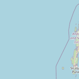
Map view of Flat Island Wildlife Sanctuary

Use this park location map to pinpoint Flat Island Wildlife Sanctuary in India, understand its exact geographic position, and read its mapped placement within the surrounding landscape more clearly.

Pigeon | © OpenStreetMap contributors

Location context for Flat Island Wildlife Sanctuary

Andaman and Nicobar Islands
Park atlas

Compare surrounding island sanctuaries and connected coastal protected areas across the archipelago.

Explore Other Parks Near Flat Island Wildlife Sanctuary And Regional Reserves

Browse nearby national parks and protected areas sharing similar marine ecosystems and tropical island geography. Compare adjacent wildlife sanctuaries to understand the broader conservation landscape surrounding the Andaman archipelago.
Wildlife reserveAndaman and Nicobar Islands
About 37 km away#1 closest

Northeast

Cuthbert Bay Wildlife Sanctuary: Coastal Habitat and Sea Turtle Nesting Ground

Eastern Middle Andaman protected coastal geography

Cuthbert Bay Wildlife Sanctuary covers 5.8 square kilometres of critical coastal terrain along the eastern Middle Andaman coastline. Renowned for its concentration of sea turtle nesting beaches, the reserve supports diverse coastal ecosystems ranging from open sand to inland forest patches. It serves as a compact but vital ecological anchor within the broader landscape of the Andaman and Nicobar Islands.

Area
5.8 km²
Established
1997
IUCN
IV
Scope
Terrestrial
Protected areaAndaman and Nicobar Islands
About 38 km away#2 closest

North

Interview Island Protected Area: Geography, Forested Plateau, and Island Map

A remote wilderness sanctuary in the Andaman archipelago

Interview Island encompasses a secluded, 23 kilometer long landscape characterized by dense tropical forests and a rising southern plateau. This protected area stands out for its feral elephant population and near-undisturbed coastal environment, providing a compelling focus for geographic exploration and study of the Andaman island chain.

Area
101 km²
Established
1997
Relief
Upland
Water
Major water bodies
National parkAndaman and Nicobar
About 48 km away#3 closest

Southeast

Middle Button Island National Park: National Park within Andaman and Nicobar's Geography

Explore protected landscape context and mapped park boundaries.

Middle Button Island National Park represents a significant protected natural landscape, offering users a focused entry point for geographic discovery. As a designated national park, it contributes distinct mapped boundaries and terrain characteristics to the Andaman and Nicobar region's atlas data. Understanding its specific identity helps contextualize the broader protected-area network and regional geography. This page details the park's role as a conserved territory, vital for those seeking structured landscape and geography information.

Area
64 km²
Established
1979
Relief
Lowland
Climate
Tropical
National parkAndaman and Nicobar Islands
About 49 km away#4 closest

Southeast

North Button Island National Park: Protected Landscape and Mapped Geographic Identity

Explore the mapped boundaries and regional natural terrain.

Gain a clear understanding of North Button Island National Park as a distinct protected landscape within the Andaman and Nicobar Islands region. This entry offers detailed geographic context, focusing on the park's mapped boundaries and its role within the archipelago's natural terrain. It serves as a foundational element for understanding this Indian National Park's place in a broader atlas of conservation areas.

Area
114 km²
Established
1979
National parkAndaman and Nicobar Islands
About 51 km away#5 closest

Southeast

South Button Island National Park: Mapped Boundaries and Regional Protected Landscape

Key National Park in the Andaman and Nicobar Islands

South Button Island National Park is a protected natural area offering critical insight into the geography of the Andaman and Nicobar Islands. This detailed view focuses on its mapped boundaries and its significance as a national park within this Indian archipelago. Understanding its position within the regional geography provides essential context for exploring protected lands and natural landscapes across the Andaman and Nicobar Islands.

Area
5 km²
Relief
Lowland
Climate
Tropical
Access
Moderate access
Wildlife reserveAndaman and Nicobar Islands
About 64 km away#6 closest

Northeast

Bamboo Island Wildlife Sanctuary: Mapping Coastal Protected Landscapes in the Andaman Archipelago

Coastal habitat, coral reefs, and littoral forest geography

Bamboo Island Wildlife Sanctuary represents a crucial protected area within the Andaman and Nicobar Islands, focusing on the interface between unique littoral bamboo thickets and surrounding marine reef environments. This reserve highlights the role of small island geography in conserving coastal stability and sensitive marine habitats within the Indian Bay of Bengal territory.

Area
0.05 km²
Established
1987
IUCN
IV
Relief
Lowland
Wildlife reserveAndaman and Nicobar Islands
About 65 km away#7 closest

South

Defence Island Wildlife Sanctuary: Protected Geography and Island Ecosystems in the Andaman Archipelago

A remote wildlife reserve within the South Andaman district

Defence Island Wildlife Sanctuary represents a key protected landform within the Andaman and Nicobar union territory. Characterized by its coastal littoral habitats and dense tropical interior, this uninhabited island reserve serves as a significant site for regional biodiversity and landscape conservation efforts in the Bay of Bengal.

Area
5.04 km²
Water
Water-dominated
Season
Year-round
National parkAndaman and Nicobar Islands
About 74 km away#8 closest

South

Mount Harriet National Park: National Park Mapping and Protected Landscape Identity

Explore its endemic biodiversity and mountain forest terrain.

Mount Harriet National Park provides a deep dive into a unique protected landscape, offering detailed insights into its geography, terrain, and ecological significance within the Andaman and Nicobar Islands. As a national park, it showcases a remarkable combination of mountainous forest ecosystems and coastal environments, serving as a vital habitat for numerous endemic species. Understanding its mapped boundaries and regional geographic context reveals why this protected area is a key point of interest for atlas-based natural landscape exploration.

Area
46.62 km²
Established
1979
IUCN
II
Relief
Mountain

Common questions about visiting, size, designation, and location context for Flat Island Wildlife Sanctuary

Flat Island Wildlife Sanctuary FAQs for park facts, access, geography, and protected area context

Find quick answers about Flat Island Wildlife Sanctuary, including protected-area facts, park geography, trail and visitor context, and how the park fits into its surrounding country and regional landscape.
MoriAtlas Explorer

Continue Your Protected Areas Search Across the Global Atlas

Deepen your exploration by continuing the structured search for national parks and protected areas worldwide. Utilize the comprehensive filtering capabilities to compare different conservation landscapes and refine your understanding of global park geography. Discover more about the distribution and characteristics of protected natural areas.

Global natural geography