
Mori Atlas logo
Nature reserveFlow Country

A vast wilderness of waterlogged plateaus, bog pools, and globally vital carbon-storing landscapes.

Flow Country Nature Reserve: Mapping the Expansive Peatland Geography of Northern Scotland

The Flow Country stands as a significant protected nature reserve in northern Scotland, encompassing thousands of square kilometers of intact blanket bog. This wilderness landscape provides a rare opportunity to study the geography of deep peat deposits, interconnected bog pools, and specialized wetland vegetation that has accumulated over thousands of years. As a UNESCO World Heritage site, the region remains a central focus for mapping the intersection of ancient geological foundations and modern climate-regulating ecosystems.

blanket bogpeatlandwetlandUNESCO World HeritageScotlandCaithness
A flat-style digital illustration showing a snowy mountain peak in the background, a waterfall cascading over cliffs in the midground, and a wetland or bog area with water channels in the foreground.

Flow Country

Nature reserve

Park overview

Structured park overview, official facts, and landscape profile for Flow Country

Flow Country park facts, protected area profile, and essential visitor context

Review the core facts for Flow Country, including designation, size, terrain, visitor scale, habitats, and operating context in one park-focused overview.

About Flow Country

The Flow Country is one of the most important wetland landscapes in the world. Stretching across the northernmost counties of Scotland, it encompasses an enormous, largely treeless expanse of blanket bog, a habitat in which a continuous layer of peat, in places many meters deep, blankets the gently rolling terrain. The bogs are studded with pools, hummocks, and a subtle mosaic of plant communities dominated by sphagnum moss, the key organism that builds the peat layer over centuries.

What sets the Flow Country apart, alongside its sheer size, is the way its ecology, hydrology, and carbon dynamics are tightly linked. Because sphagnum moss holds water and grows slowly, year after year, the system accumulates organic material faster than it can fully decompose. The result is a vast long-term reservoir of carbon in the peat itself, a natural buffer against atmospheric carbon dioxide and a defining feature of the landscape's global importance.

The Flow Country holds formal recognition at multiple levels. The Caithness and Sutherland Peatlands are protected under European wildlife legislation as both a Special Protection Area and a Special Area of Conservation, and the RSPB's Forsinard Flows National Nature Reserve anchors active conservation in the heart of the region. In 2024, UNESCO listed the Flow Country as a World Heritage Site, placing it alongside the Giant's Causeway and the Jurassic Coast as one of only three natural World Heritage landscapes in the United Kingdom.

Quick facts and research context for Flow Country

The Flow Country lies in Caithness and Sutherland in northern Scotland and extends across approximately 4,000 square kilometers, making it the largest blanket bog in Europe. Its inscribed World Heritage area covers around 187,000 hectares.

The landscape is dominated by deep blanket peat formed primarily from sphagnum moss, with the underlying bedrock belonging to ancient geological units including Lewisian gneiss, the Moine succession, and Devonian Old Red Sandstone. Large portions are protected as the Caithness and Sutherland Peatlands Special Protection Area and Special Area of Conservation, and the heart of the area includes the RSPB-managed Forsinard Flows National Nature Reserve.

Protection and recognition

Documented terrestrial protection scope, designation history, and official recognition sources.

Flow Country Protection Status and UNESCO World Heritage Recognition

Flow Country holds verified terrestrial protection status established in 2024 alongside official UNESCO World Heritage recognition. Structured records assemble complete designation history, management scope, and international recognition sources for detailed analysis.

International recognition

Protection details

Protection scope
Terrestrial
Designated year
2024
Transboundary protection
No
Park context

Deeper park guide and search-rich context for Flow Country

Flow Country history, landscape, wildlife, and travel context

Explore Flow Country through its history, landscape character, ecosystems, wildlife, conservation priorities, cultural context, and seasonal travel timing in a structured park guide built for atlas discovery and search intent.

Why Flow Country stands out

The Flow Country is best known as Europe's largest blanket bog, a continuous expanse of peatland in northern Scotland that has developed over thousands of years from accumulated sphagnum moss and other wetland vegetation. Its immense stores of carbon and its role in stabilizing the global climate are central to its modern identity. The area is equally celebrated for its specialist bog wildlife: breeding populations of waders such as golden plover, dunlin, and greenshank, hunting hen harriers and merlins, and rare carnivorous plants like sundews and butterworts that thrive in the nutrient-poor, waterlogged peat. The combination of active bog formation, distinctive fauna, and globally significant carbon storage gives the Flow Country a profile unlike almost any other landscape in Europe.
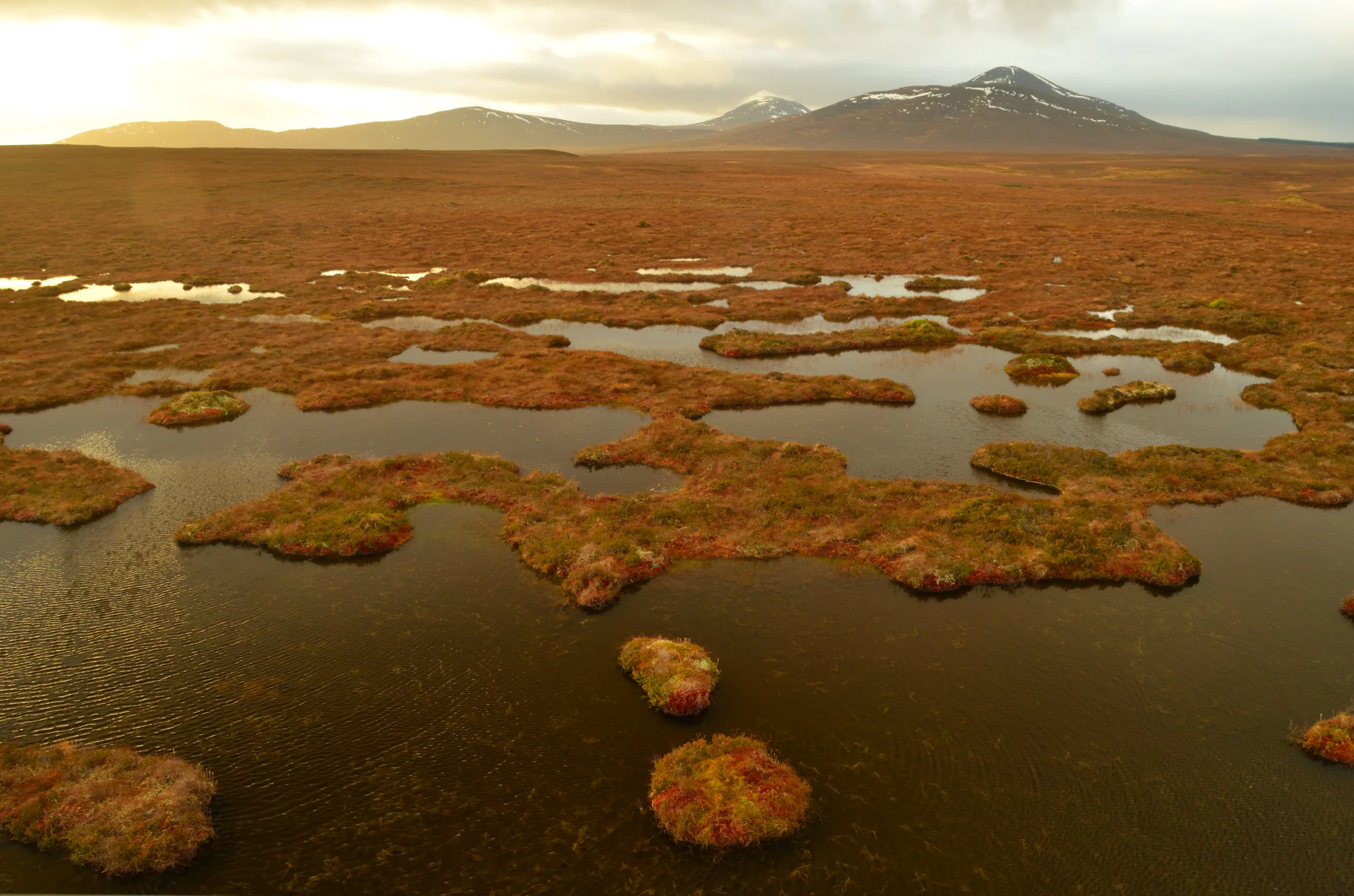
A wide aerial view of the Flow Country in Scotland, showing a vast, flat expanse of peatland bog with scattered dark water pools and low-lying vegetation under a sunset-lit sky.
The expansive blanket bog landscape of the Flow Country, characterized by numerous pools and patches of vegetation under a soft, golden light.

Flow Country history and protected-area timeline

The name "Flow" comes from a Scots word for a bog or morass, likely derived from Old Norse, and echoes the Icelandic word for a similar watery landscape. The bogs themselves are ancient in ecological terms, having begun to develop at the end of the last ice age as the land became wetter and plant material started to accumulate.

For most of its history the Flow Country was a remote and lightly used landscape, with traditional activities such as sheep grazing having only modest impact on the deep peat. That changed dramatically in the second half of the twentieth century, when government tax reliefs encouraged large-scale commercial forestry in the region. From the 1970s onward, extensive areas of bog were drained and planted with non-native conifers, severely damaging the peatland habitat and releasing stored carbon as the bogs degraded.

Conservationists pushed back against this transformation. In 1987, the Nature Conservancy Council published a highly critical report on forestry practices in the Flow Country, and the following year Chancellor Nigel Lawson used the Finance Act 1988 to scrap the controversial forestry tax reliefs. This halted further damaging plantation expansion and marked a turning point in the protection of the area. The RSPB subsequently acquired large tracts in the heart of the Flow Country, removing plantations and restoring degraded ground, an effort that paved the way for later international recognition and ultimately for the 2024 UNESCO World Heritage inscription.

Flow Country landscape and geographic character

The Flow Country is a sweeping, open landscape, defined less by dramatic relief than by its gently undulating plateau surface and its almost continuous covering of peat. Underfoot the ground is spongy and waterlogged, with countless bog pools, hollows, and low ridges giving subtle texture to what at first glance appears a uniform expanse of bog. Streams and small rivers thread through the area, their dark, peat-stained waters a hallmark of this environment.

Geologically, the visible landscape is dominated by Quaternary deposits laid down during and after the last glaciation. Peat sits at the surface, but beneath it lie glacial tills and post-glacial alluvial sediments accumulating through thousands of years. The bedrock that ultimately shapes the terrain is far older: ancient Archaean and Palaeoproterozoic Lewisian gneiss forms much of the foundation, with the Neoproterozoic Moine succession and intruded Ordovician to Silurian granites added to the mix, and substantial areas of Devonian Old Red Sandstone on top. Together these layers create the cold, often nutrient-poor substrate that supports the bog rather than forests or farmland.

The result is a landscape of muted colors: russet and gold moorland, deep green moss carpets, and reflective pools under wide northern skies. There are few trees over most of the area, which reinforces the sense of openness, and the horizon is occasionally broken by distant peaks such as Ben Griams when viewed from locations like Forsinard.
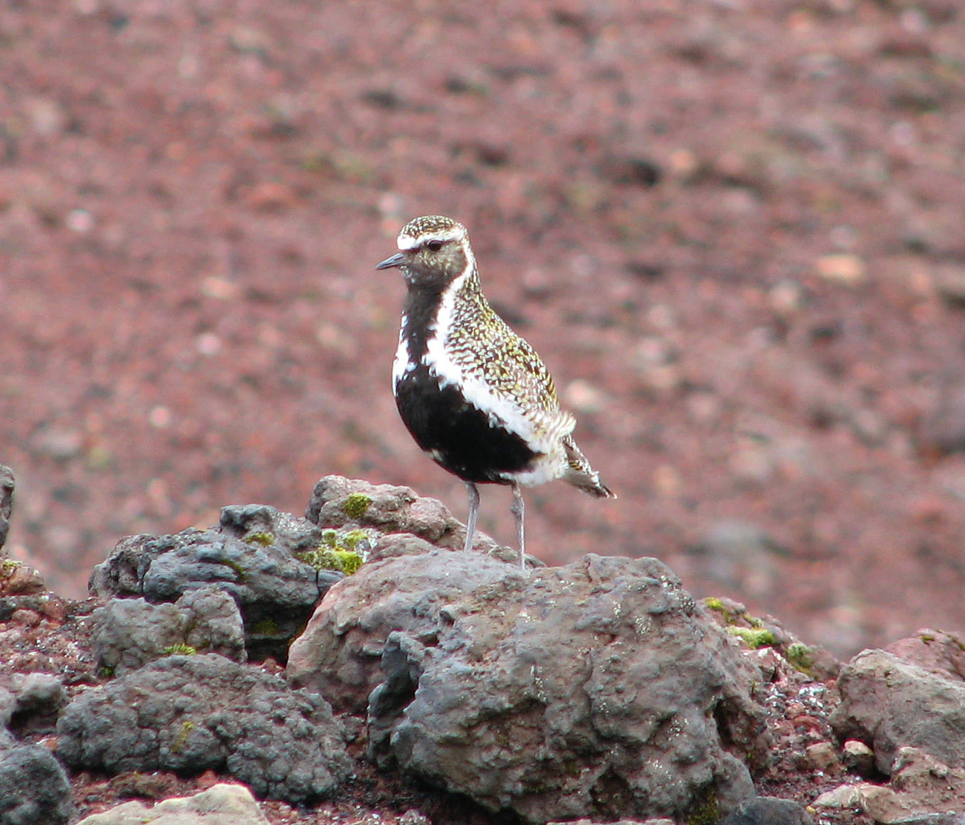
A golden plover bird with speckled brown plumage and a black breast standing on dark, uneven volcanic-looking rocks.
A golden plover bird standing on a rocky outcrop in the Flow Country.

Flow Country ecosystems, habitats, and plant life

Ecologically, the Flow Country is dominated by active blanket bog, one of the rarest and most fragile habitat types in Europe. Sphagnum moss is the ecological engineer of the system: it absorbs and holds large quantities of water, acidifies its surroundings, and slowly converts into peat as new growth builds on old. Over thousands of years this has produced a deep, waterlogged peat layer across most of the landscape.

The bog is far from lifeless. Nutrient-poor conditions favor specialist plants adapted to these harsh settings. Carnivorous species such as round-leaved sundew, greater sundew, and common butterwort thrive here, capturing insects to supplement their mineral nutrition. A broader flora of sedges, cotton grasses, heathers, and other bog plants forms the visible vegetation, painting the surface in seasonal colors. Insect life is correspondingly rich, fueling both the carnivorous plants and the food webs that support breeding birds.

Hydrology is the key ecological driver. The blanket bog depends on consistent high water tables; if these drop, peat formation slows, plants change, and the system begins to dry out and lose carbon. This sensitivity to drainage and land use is what makes the Flow Country both ecologically valuable and ecologically vulnerable, and it is the reason restoration work focuses so heavily on re-wetting previously drained ground.
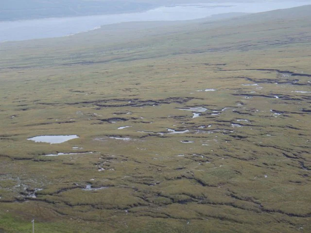
A wide, elevated view of a vast, flat, grassy peatland landscape with numerous small ponds and dark, winding drainage channels leading toward a larger body of water in the distance.
The expansive blanket bog landscape of the Flow Country, featuring characteristic pool systems and gentle slopes.

Flow Country wildlife and species highlights

The Flow Country is one of the most important strongholds for breeding waders in the United Kingdom. Open bogs and moorland pools provide nesting habitat for species such as golden plover, dunlin, and greenshank, whose populations here are significant at a European scale. These ground-nesting birds are characteristic of the area in spring and summer, defining its soundscape and visual identity.

Birds of prey are a regular feature of the skies above the bog. Hen harriers and merlins hunt over the open expanse, while common buzzards are also present, taking advantage of the small mammals, passerines, and invertebrates that share the habitat. The combination of abundant prey and large, undisturbed hunting grounds makes the Flow Country particularly attractive for raptors during the breeding season.

Larger mammals also inhabit the area. Red deer are common throughout the Flow Country and are visible across the open moorland, and the more localized roe deer is also present. In autumn, the red deer rut is a notable seasonal event, with stags audible as they compete across the bog. Among smaller fauna, the invertebrate communities thriving in the wet, acidic conditions are a crucial part of the food web, sustaining both carnivorous plants and breeding birds.
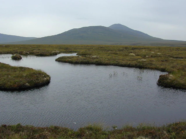
A wide shot of a blanket bog landscape with dark pools of water in the foreground, mossy peat terrain, and distant rolling hills under a cloudy sky.
A view across the peat bogs of the Flow Country towards the hills in the distance.

Flow Country conservation status and protection priorities

The Flow Country's conservation significance operates on a global scale. Because intact blanket bog continuously accumulates peat, the Flow Country locks up enormous quantities of carbon that would otherwise contribute to atmospheric carbon dioxide and global warming. Preserving the bog hydrology and preventing degradation is therefore a direct contribution to climate stability, not only a matter of habitat protection.

Recognition of this value has built over decades. Large parts of the area are now protected as the Caithness and Sutherland Peatlands, designated under European law as both a Special Protection Area for its birdlife and a Special Area of Conservation for its habitats. At the heart of the region, the RSPB runs the Forsinard Flows National Nature Reserve and previously led the Flows to the Future Project, an initiative that combined large-scale peatland restoration with efforts to raise public understanding of the area's importance, including the creation of the Flows Lookout Tower.

The most significant milestone came in 2024, when UNESCO inscribed the Flow Country as a World Heritage Site under natural criterion ix. This recognized the area as an outstanding example of an ongoing blanket bog ecosystem and its associated habitats, placing it alongside the Giant's Causeway and the Jurassic Coast as one of the three natural World Heritage landscapes of the United Kingdom.

Flow Country cultural meaning and human context

The cultural identity of the Flow Country is shaped by its Gaelic and Scots linguistic heritage, reflected in place names such as the Scottish Gaelic "Dùthaich nam Boglaichean". The word "flow" itself is part of the Scots vocabulary shared with Old Norse and Icelandic, linking the peatlands of northern Scotland to wider North Atlantic cultural roots.

Human presence in the Flow Country has historically been low-intensity, with traditional land uses such as sheep grazing defining rural life around the edges of the bog rather than within it. Local communities in Caithness and Sutherland have long understood the area as both a working landscape and a distinctive part of regional identity, a place that has shaped livelihoods, place-names, and folklore even where few people lived directly on the peat itself.

Top sights and standout views in Flow Country

The Flow Country's greatest highlights revolve around its ecological completeness rather than dramatic single landmarks. The sheer unbroken expanse of intact blanket bog is the headline feature, with thousands of square kilometers of moss-dominated peatland dotted with bog pools and supporting specialist plant and animal communities found almost nowhere else at this scale.

Equally striking is the area's role in global climate regulation: the deep peat holds vast carbon stores, making the Flow Country one of the largest natural terrestrial carbon sinks in Europe. Combined with breeding populations of iconic waders and raptors, ongoing peatland restoration projects, and its 2024 UNESCO World Heritage status, the Flow Country offers a profile that combines biodiversity, landscape, and climate significance in a single, cohesive wilderness.

Best time to visit Flow Country

The Flow Country has a markedly seasonal character shaped by the northern Scottish climate. Late spring and early summer are typically the most rewarding seasons for visiting, when breeding waders are active and the open bog comes alive with birdsong, flowering plants, and the widest range of wildlife activity. Warmer temperatures also make walking across the often challenging bog terrain more comfortable, though waterproof clothing is still essential.

Autumn brings a very different atmosphere: the russet and red tones of moorland vegetation deepen, and red deer are at their most vocal during the rut. Winter can be harsh, with short days, cold weather, and often soaked ground, conditions that favor fewer visitors but reward those interested in quiet landscapes, atmospheric skies, and wintering birdlife. In any season, visitors should expect rapid weather changes and remote terrain, and plan accordingly.
Monthly climate preview

Track monthly temperature ranges and precipitation averages across the protected landscape

Flow Country Climate Normals and Long Term Temperature Patterns

Representative baseline coordinates record long term temperature variations alongside consistent daily precipitation measurements throughout the year. Examining the full twelve month record reveals deeper climatic rhythms and detailed monthly meteorological averages for the protected area.
Annual mean8 °C
4 °C13 °C
Jan
Feb
Mar
Apr
May
Jun11°
Jul13°
Aug13°
Sep12°
Oct
Nov
Dec
Warmest month
August

13.3 °C

Coolest month
February

4.3 °C

Wettest month
October

3.7 mm/day

Driest month
April

2.2 mm/day

Park location guide

Geography guide, regional context, and park location map for Flow Country

Flow Country park geography, regions, and map view in United Kingdom

Understand where Flow Country sits in United Kingdom through a broader geographic reading of the surrounding landscape, nearby location context, and its mapped position within the national park landscape.

How Flow Country fits into United Kingdom

The United Kingdom is a parliamentary constitutional monarchy located in northwestern Europe, consisting of four constituent countries: England, Scotland, Wales, and Northern Ireland. As a major global power with over 69 million residents, it maintains significant international influence in politics, economics, and culture.

Wider geography shaping Flow Country in United Kingdom

The United Kingdom is an island nation located in northwestern Europe, surrounded by the Atlantic Ocean, North Sea, English Channel, Celtic Sea, and Irish Sea. It shares a land border with the Republic of Ireland to the west. The territory includes the island of Great Britain, the northeastern portion of Ireland, and most of the smaller British Isles islands.

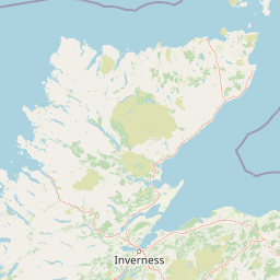
Map view of Flow Country

Use this park location map to pinpoint Flow Country in United Kingdom, understand its exact geographic position, and read its mapped placement within the surrounding landscape more clearly.

Pigeon | © OpenStreetMap contributors

Location context for Flow Country

Scotland

Examine the sweeping terrain, reflective bog pools, and protected wetland habitats of northern Scotland.

Flow Country Photos and Landscape Scenery: Visualising Europe's Largest Blanket Bog

Visual documentation reveals the vast open expanses, spongy peat terrain, and subtle surface textures that define the Flow Country environment. Photographic archives help researchers and naturalists examine regional habitats, wetland ecology, and protected landscape characteristics more deeply.

A wide aerial view of the Flow Country in Scotland, showing a vast, flat expanse of peatland bog with scattered dark water pools and low-lying vegetation under a sunset-lit sky.

A wide landscape showing a foreground of cleared land and gravel, transitioning to brown peatland vegetation with tall grass, and a dense line of pine forest in the distance.

A golden plover bird with speckled brown plumage and a black breast standing on dark, uneven volcanic-looking rocks.

A wide, elevated view of a vast, flat, grassy peatland landscape with numerous small ponds and dark, winding drainage channels leading toward a larger body of water in the distance.

A wide shot of a blanket bog landscape with dark pools of water in the foreground, mossy peat terrain, and distant rolling hills under a cloudy sky.

Park atlas

Compare surrounding regional geography and adjacent wetland habitats.

Other Parks Near Flow Country and Connected Northern Protected Landscapes

Browsing other parks near Flow Country reveals the wider ecological character and protected terrain of northern Scotland. Comparing adjacent reserves helps place vast blanket bogs and peatland ecosystems within a broader regional conservation framework.
Nature reserveScotland
About 23 km away#1 closest

Southeast

East Caithness Cliffs Nature Reserve: Regional Geography and Coastal Protected Area Atlas

Coastal sandstone cliffs and maritime heath habitats in northern Scotland.

Examine the layered conservation architecture and physical geography of East Caithness Cliffs. This site serves as a prime example of protected northern coastal terrain, where sandstone formations and maritime heath support vast seabird populations across a mosaic of land and sea boundaries.

Area
116.96 km²
Established
1996
Relief
Upland
Climate
Temperate
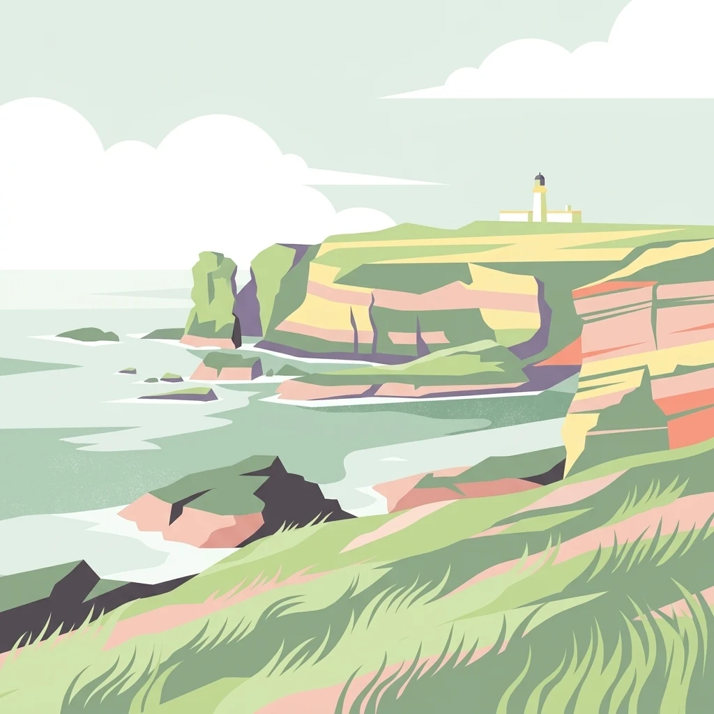
A minimalist, stylized vector illustration of coastal cliffs meeting the sea, with a lighthouse visible in the distance on top of the headland.
Marine protected areaHighland
About 39 km away#2 closest

East

Noss Head Marine Protected Area: Highland Coastal and Benthic Geography

Exploring the rocky cliffs and offshore mussel habitats of Northern Scotland.

Noss Head is a notable marine protected area located on the Caithness coast of the Scottish Highlands. The site is defined by its rugged coastal cliffs and an expansive, nationally important horse mussel bed that occupies the seabed at depths between 35 and 45 metres. This area represents a core study in North Atlantic benthic ecology and dramatic maritime landforms.

Area
8 km²
Established
2014
IUCN
IV
Relief
Lowland
Watercolor painting of soft rolling dunes, green hills, and light clouds.
Protected areaSutherland
About 56 km away#3 closest

South

Coul Links Protected Area: Coastal Dune and Heathland Geography in Sutherland, Scotland

A study of coastal dune succession and wetland terrain

Coul Links serves as a quintessential example of a Scottish coastal links landscape, tracing a continuous path from active beach fronts through to stable, juniper-rich heathland. Situated in Sutherland, the site offers a window into the formation of dune slacks, seasonal freshwater lochans, and the ecological dynamics of a complex, interwoven coastal system.

Relief
Lowland
Climate
Temperate
Access
Easy access
Scope
Terrestrial
A wide watercolor illustration showing a mountain range in the distance, a valley, and green forests on either side, with soft pastel colors.
Protected landscapeHighland
About 71 km away#4 closest

West

North West Sutherland National Scenic Area: Mapping the Peaks and Coasts of Highland Scotland

Protected quartzite mountain landscapes and Atlantic coastal geography

This detailed overview of the North West Sutherland National Scenic Area maps the dramatic interplay between the white quartzite mountains of Foinaven and Arkle and the darker Lewisian gneiss that forms the underlying Highland landscape. The analysis provides deep insights into the region's knock and lochan topography, sea lochs, and the protected coastal habitats of Handa Island, anchoring the area within its broader Scottish geological context.

Area
266 km²
Established
1981
Relief
Mountain
Climate
Temperate
Wildlife reserveOrkney
About 89 km away#5 closest

Northeast

Rousay Wildlife Reserve: Mapped Geography and Protected Landscapes in the Orkney Archipelago

Island moorlands, coastal cliffs, and freshwater loch ecosystems.

Rousay represents a critical protected area within the Orkney islands, characterized by its elevated moorland summits and dramatic shorelines. The mapped terrain reveals complex interactions between marine sounds and terrestrial habitats, offering a deep look into the regional geography and conservation status of this northern sanctuary.

Area
48.6 km²
Relief
Upland
Climate
Temperate
Access
Moderate access
Watercolor painting depicting mountains, forested hills, and a river in a scenic landscape
National parkScotland
About 110 km away#6 closest

South

Cairngorms National Park: Explore Scotland's Largest Protected Mountain Landscape

Mapped boundaries and arctic-alpine geography.

As the United Kingdom's largest national park, Cairngorms National Park in Scotland presents a vast expanse of distinctive arctic-alpine terrain and ancient Caledonian forests. This protected landscape offers a unique opportunity to explore mapped geographic features, from its extensive mountain plateaus to its vital river systems. Discover the contours and context of this significant natural area within the broader atlas of Scotland's protected lands.

Area
4,528 km²
Established
2003
IUCN
V
Visitors
1.9M annual
Protected landscapeHighland
About 121 km away#7 closest

Southwest

Wester Ross National Scenic Area: Protected Highland Mountain and Coastal Landscape Atlas

Geographic mapping of the Northwest Highlands terrain

Wester Ross National Scenic Area spans vast stretches of the Northwest Highlands, characterized by towering Torridonian sandstone peaks and deeply carved sea lochs. This protected region integrates ancient Scots pine forests, glacial-carved glens, and complex coastal environments into one of the most recognizable geographic features of Scotland. The landscape serves as a vital record of geological heritage and high-latitude biodiversity within the Highland administrative region.

Area
1,634.58 km²
Established
1981
Visitors
70K annual
Relief
Mountain
A soft, impressionistic watercolor painting of a Scottish loch surrounded by rolling green hills and distant mountain silhouettes.
Marine protected areaRoss and Cromarty
About 158 km away#8 closest

Southwest

Loch Carron Marine Protected Area: Coastal Geography and Protected Seabed Landscape Atlas

Exploring the tidal basins and underwater terrain of Ross and Cromarty.

Loch Carron stands as a landmark marine protected area defined by its dramatic underwater depth changes and robust tidal currents. This protected sea loch features the world's largest flame shell colony nestled beneath the cliffs at Strome Castle. The surrounding Highland geography of Ross and Cromarty creates a compressed, mountain-framed landscape that influences the rich ecological character of this essential coastal habitat.

Area
23 km²
Established
2019
Relief
Lowland
Climate
Temperate

Common questions about visiting, size, designation, and location context for Flow Country

Flow Country FAQs for park facts, access, geography, and protected area context

Find quick answers about Flow Country, including protected-area facts, park geography, trail and visitor context, and how the park fits into its surrounding country and regional landscape.
MoriAtlas Explorer

Continue Your Protected Areas Search Across the Global Atlas

Deepen your exploration by continuing the structured search for national parks and protected areas worldwide. Utilize the comprehensive filtering capabilities to compare different conservation landscapes and refine your understanding of global park geography. Discover more about the distribution and characteristics of protected natural areas.

Global natural geography