

Mori Atlas logo
Nature reserveForbachsee bei Bebra

Mapping the evolving landscape and river-reclaimed habitats of this protected reserve

Forbachsee bei Bebra Nature Reserve: An Atlas of Fulda River Floodplain Geography

Forbachsee bei Bebra represents a significant example of secondary habitat restoration within the middle Fulda valley of northern Hesse. Once a gravel quarry, this protected landscape has been reconnected to the river, creating a dynamic mosaic of wetlands, pioneer floodplain forests, and shifting gravel bars. Explore the topographic interaction between the river and the basin, providing a crucial corridor for waterfowl in a structured, atlas-focused format.

gravel-pit lakefloodplainriver-floodplainriparian forestsoftwood floodplain forestwaterbird habitat

Forbachsee bei Bebra

Nature reserve

Park overview

Structured park overview, official facts, and landscape profile for Forbachsee bei Bebra

Forbachsee bei Bebra park facts, protected area profile, and essential visitor context

Review the core facts for Forbachsee bei Bebra, including designation, size, terrain, visitor scale, habitats, and operating context in one park-focused overview.

About Forbachsee bei Bebra

Forbachsee bei Bebra is a small but ecologically significant nature reserve in the floodplain of the middle Fulda, in the northern Hessian district of Hersfeld-Rotenburg. The roughly 22-hectare site centres on a former gravel pit that now functions as a dynamic lake closely intertwined with the main river, and includes about a kilometre of the Fulda itself along with softwood floodplain forest, wet tall-herb vegetation, and marshy woodland.

The reserve was established in 1985 after the Fulda broke through the embankment separating the abandoned quarry from the river during a major flood in the mid-1980s. Once the connection was opened, repeated high-water events continued to reshape the openings, and Fulda water began flowing through the lake even at ordinary levels. This rare situation, where a former extraction pit is still actively shaped by river dynamics, lies at the heart of the site's conservation value.

Decades later, the lake and its surroundings have matured into a layered habitat mosaic. Pioneer softwood floodplain forest dominated by willow and other moisture-loving species has colonised much of the former pit area, while patches of tall-herb vegetation line the water's edge and alder-ash woodland edges the floodplain. The reserve sits fully inside both the European bird protection area "Fuldatal zwischen Rotenburg und Niederaula" and the landscape protection area "Auenverbund Fulda", and forms a small but characteristic example of how working floodplains in Hesse can integrate former industrial sites into a coherent ecological network.

Quick facts and research context for Forbachsee bei Bebra

Forbachsee bei Bebra is a nature reserve and European FFH site in the Landkreis Hersfeld-Rotenburg of Hesse, roughly one kilometre west of the town of Bebra. It lies in the Bebraer Becken subunit of the Fulda-Werra-Bergland natural region, within the floodplain of the middle course of the River Fulda, just a few kilometres south of Rotenburg an der Fulda.

The protected area covers about 22 hectares, of which the former gravel pit lake forms the core; the lake averages around four metres in depth. It is designated as a Naturschutzgebiet under German nature conservation law, as a Fauna-Flora-Habitat-Gebiet within Natura 2000 (site 5024-301), and falls fully inside both the European bird protection area "Fuldatal zwischen Rotenburg und Niederaula" and the larger landscape protection area "Auenverbund Fulda". The site is officially classified as an IUCN Category IV Habitat/Species Management Area, reflecting its focus on active management and habitat protection rather than wilderness preservation.

Protection and recognition

Documented terrestrial protection history and Natura 2000 designation records

Forbachsee bei Bebra Protection Status and International Recognition Data

Terrestrial protection status for Forbachsee bei Bebra includes established designation history and official Natura 2000 recognition records. Structured conservation data details the official administrative framework governing the protected landscape since 2008.

International recognition

Protection details

Protection scope
Terrestrial
Designated year
2008
Transboundary protection
No
WDPA ID
163125
Park context

Deeper park guide and search-rich context for Forbachsee bei Bebra

Forbachsee bei Bebra history, landscape, wildlife, and travel context

Explore Forbachsee bei Bebra through its history, landscape character, ecosystems, wildlife, conservation priorities, cultural context, and seasonal travel timing in a structured park guide built for atlas discovery and search intent.

Why Forbachsee bei Bebra stands out

Forbachsee bei Bebra is best known for being a former gravel quarry that has been reclaimed by the Fulda and now functions as a dynamic floodplain lake at the heart of a small but ecologically rich nature reserve. Its defining feature is the reconnection between the quarry lake and the river: a flood in the mid-1980s breached the separating embankment, and successive high-water events have since deepened and shifted the openings, so that Fulda water now flows through the lake even under normal conditions. This continuous reshaping by the river creates a shifting mosaic of shallow water, gravel banks, deadwood jams, and small cliffs, which in turn supports a varied waterbird community. The reserve is widely recognised in Hesse as a regionally important breeding, resting, and wintering site for waterbirds, including several species listed under Annex I of the EU Birds Directive. Together with the surrounding floodplain forest and a short stretch of the Fulda, it forms a compact showcase of how abandoned extraction sites in a river landscape can become valuable secondary habitats.
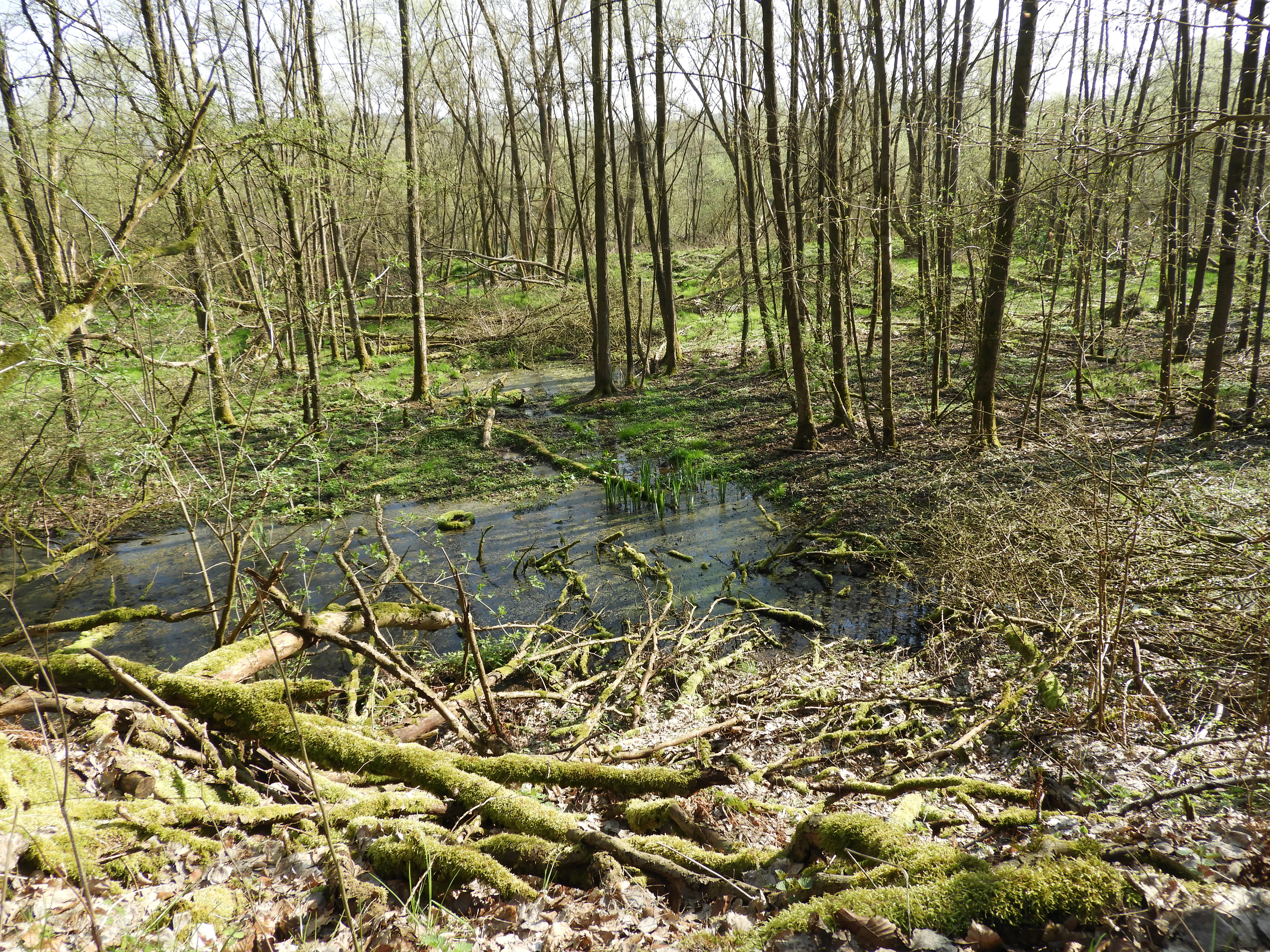
Swamp forest in the Forbachsee nature reserve
A view of the swamp forest within the Forbachsee bei Bebra nature reserve, a former gravel extraction site now designated as a protected area and Natura 2000 site near Bebra, Germany.

Forbachsee bei Bebra history and protected-area timeline

The landscape around the Forbachsee has been shaped by human activity since the early Middle Ages. As the population of the Fulda valley grew, woodland was cleared, slopes were eroded by farming, and the original gravel and sand terraces of the glacial river were gradually buried under thick layers of floodplain loam. These loam soils enabled more intensive agriculture in the valley.

From the Middle Ages onward, the Fulda itself was progressively straightened and canalised in repeated attempts to render it navigable as far downstream as Bad Hersfeld, and further rerouting took place during the construction of railways and roads. By the first half of the nineteenth century the river had largely reached the course it still follows today. In the twentieth century, the gravel and sand deposits of the Fulda valley became a valuable resource for the construction industry. Large-scale extraction opened up pits in the floodplain, and the Forbachsee emerged from two of these former workings, now joined into a single roughly 22-hectare lake with an average depth of about four metres.

After extraction ended, the site was acquired as a compensatory measure linked to the construction of a new railway line. In 1985 it was formally designated as the Naturschutzgebiet "Forbachsee bei Bebra" by the regional forestry and nature conservation authority in Kassel, with the explicit goal of protecting the lake, its surroundings, and an adjacent stretch of the Fulda as a habitat for a rich flora and fauna, especially waterbirds. During a major flood in the mid-1980s the Fulda breached the embankment that had separated the lake from the river, and successive high-water events deepened the openings, creating the dynamic connection between river and pit that defines the site today. In the early 2000s, waterway authorities repeatedly called for the breaches to be sealed, but conservation groups, whose priority is process protection with natural floodplain dynamics and free succession, successfully resisted the proposal. In 1999 the area was reported to the European Commission as part of the Natura 2000 network and was formally designated as a Fauna-Flora-Habitat site in 2008.

Forbachsee bei Bebra landscape and geographic character

The landscape of Forbachsee bei Bebra is dominated by a low-lying stretch of the middle Fulda valley in northern Hesse. The reserve lies in the Bebraer Becken, a basin within the broader Fulda-Werra-Bergland and the Osthessisches Bergland, framed by the Neuenstein-Ludwigsecker ridge to the west and bordered upstream and downstream by other sections of the Fulda floodplain. Elevations within the protected area are modest, lying only a few metres above the river between roughly 188 m and 190 m.

Topographically, the site is a flat floodplain punctuated by the unusual presence of standing water. The lake itself was not shaped by natural processes but by gravel extraction, and it sits between roughly 1.5 and 4 metres deep across most of its surface. Originally separated from the river by a narrow dam-like embankment, the lake has since been opened up by the Fulda through a series of breaches, so that the present-day shoreline is in constant flux.

The eye-level scenery around the lake shifts between open water, low gravel and sand banks, reed-fringed shallows and softwood thickets. Patches of tall-herb vegetation border the shore, while on slightly higher ground, broad swathes of young floodplain forest close the view in places. A roughly one-kilometre stretch of the Fulda itself runs along the eastern side of the reserve, with water flowing from the river through the lake and out again, producing small cliffs, log jams and shifting bars along the way.
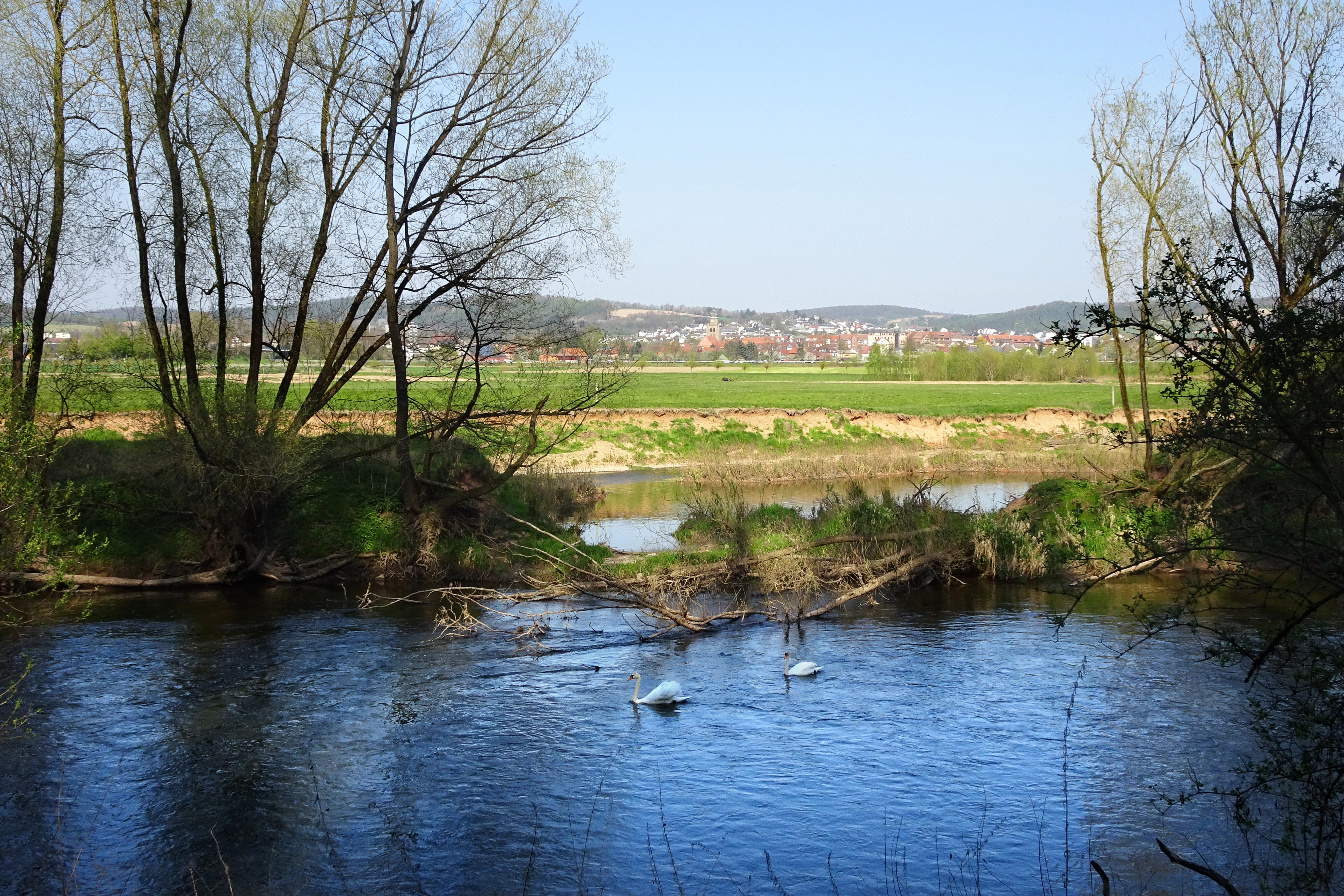
Fulda River near Bebra
View of the Fulda River near the Forbachsee nature reserve, a former gravel mining area designated as a protected nature reserve and Natura 2000 site.

Forbachsee bei Bebra ecosystems, habitats, and plant life

Ecologically, Forbachsee bei Bebra is a compact example of a recovering floodplain ecosystem built around a former gravel pit. The site has moved through several vegetation stages: from open water and bare gravel banks typical of an active pit, through ruderal and tall-herb communities with nettles and Impatiens, to the early softwood floodplain forest that now dominates large parts of the shoreline.

Several habitat types recognised under the EU Habitats Directive are present within the reserve. The Fulda itself, now flowing partly through the lake, supports a Ranunculion fluitantis-type community dominated by spiked watermilfoil (Myriophyllum spicatum), alongside river water-crowfoot and hooked water-starwort. Moist tall-herb fringes line the water, though they are relatively species-poor here and dominated by common species, with large stands of stinging nettle and invasive Himalayan balsam. The most extensive habitat type is the young alder-ash and softwood floodplain forest (habitat type *91E0), which has developed mainly since the site was placed under protection, covering around 8.5 hectares and still partly in the pioneer forest stage. A small fragment of low-stature beech forest (habitat type 9110) is included where the boundary of the FFH area extends slightly beyond the floodplain itself. Small ponds and ditch structures created during earlier site management, together with seasonally flooded channels, provide potential habitat for beaver.
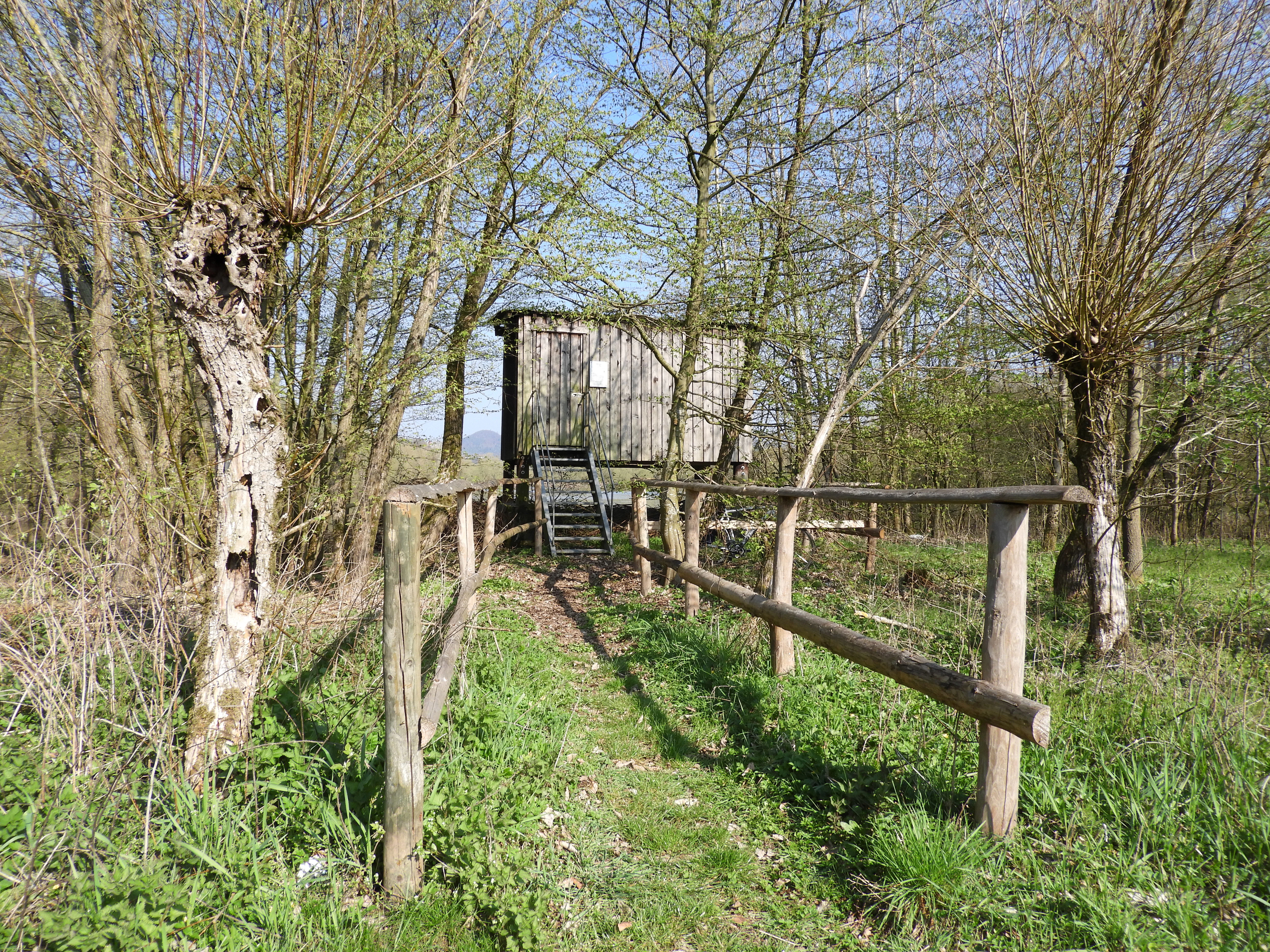
Forbachsee bei Bebra Nature Reserve
A nature reserve and Natura 2000 site located west of Bebra in the Hersfeld-Rotenburg district. The area is a former gravel extraction site that has been reclaimed as a protected habitat.

Forbachsee bei Bebra wildlife and species highlights

The wildlife profile of Forbachsee bei Bebra is dominated by birds, especially waterbirds and riparian species, which is the reason the area was placed under protection in the first place. As the vegetation around the lake has matured from open gravel and mud into denser reed and willow cover, the bird community has shifted. Early on, the bare margins attracted waders in significant numbers; today, the densely vegetated banks support a different suite of species, while the lake retains an outstanding role as a wintering site.

Several Annex I species of the EU Birds Directive use the area as passage migrants, including ferruginous duck, smew, black and red kites, osprey, marsh harrier, hen harrier, wood sandpiper and black tern. Black, grey and middle spotted woodpeckers visit as foraging guests, and the common kingfisher breeds here regularly if not every year. In winter the lake has particular importance because the inflowing Fulda arm keeps much of the surface ice-free even when neighbouring gravel-pit lakes freeze over. Mallard is the most abundant species, with regular winter visitors including wigeon, gadwall, tufted duck, Eurasian teal, common pochard and common goldeneye. Beavers are considered likely residents in the wetland channels and small ponds within the reserve.
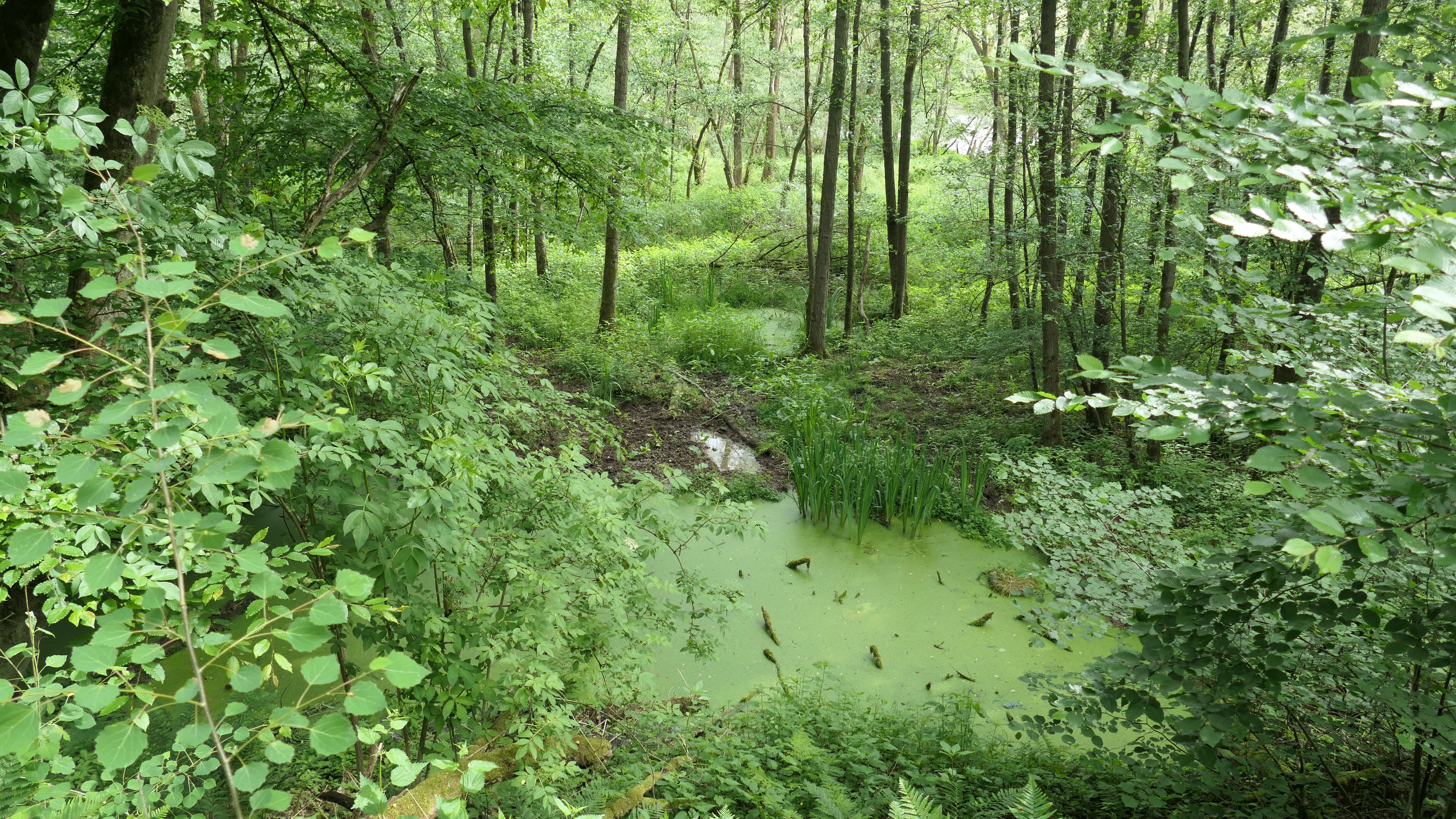
Swamp forest in the Forbachsee nature reserve
A 21.93 hectare nature reserve located west of Bebra in the Hersfeld-Rotenburg district, designated as part of the Natura 2000 network and the Fuldatal bird sanctuary.

Forbachsee bei Bebra conservation status and protection priorities

Forbachsee bei Bebra is a textbook example of layered European and national protection in Germany. The site was first legally designated as a Naturschutzgebiet in November 1985 by the regional forestry authority in Kassel, with the explicit purpose of securing the lake, its surroundings, and an adjacent stretch of the Fulda as habitat for a rich flora and fauna, and as breeding, resting and wintering habitat for numerous, partly rare bird species. The national identifier is 1632010 and the WDPA code 163125.

In 1999 the area was reported to the European Commission under the Habitats Directive as part of the emerging Natura 2000 network, and in 2008 it was formally designated as a Fauna-Flora-Habitat-Gebiet (site 5024-301) covering 22 hectares with the same boundaries as the older national reserve. Its mandatory conservation objectives include the preservation of a natural or near-natural flowing-water dynamic and the maintenance of a functional connection with typical floodplain contact habitats. The reserve also lies entirely within the European bird protection area "Fuldatal zwischen Rotenburg und Niederaula" and the larger landscape protection area "Auenverbund Fulda". A particular conservation priority, which has at times conflicted with waterway management interests, is allowing the Fulda to continue shaping the former quarry through floods, gravel deposition and erosion, rather than artificially re-closing the breaches.

Forbachsee bei Bebra cultural meaning and human context

The cultural context of Forbachsee bei Bebra is modest but rooted in the long human history of the middle Fulda valley. The transformation of the floodplain began in the early Middle Ages, when growing settlement and clearance of the surrounding slopes turned the area into a working agricultural landscape and triggered the deposition of thick layers of floodplain loam. The Fulda itself was repeatedly straightened for navigation and influenced by the construction of railways and roads, so that today's river course is largely the product of nineteenth-century engineering.

Twentieth-century gravel extraction continued this human imprint, leaving the pit lakes that now anchor much of the valley's biodiversity. Local conservation groups, notably the "Naturkundliche Gesellschaft Mittleres Fuldatal", have played a visible role in shaping the site: in 1998 and 1999 they built an observation hide with information panels at the southern edge of the reserve, providing the main public viewpoint onto the lake and its bird life.

Top sights and standout views in Forbachsee bei Bebra

The Forbachsee highlights an unusual bridging of nature and industry: a working gravel quarry was rescued from complete abandonment and, through formal protection since 1985, has matured into a regionally important nature reserve. The defining character of the site comes from the interaction between the Fulda and the lake. A breach in the separating embankment during a major flood in the mid-1980s turned the static quarry lake into a living floodplain waterbody, and the river has not stopped reshaping it since.

Ecologically, the reserve is compact but layered, combining open water, pioneer softwood floodplain forest, wet tall-herb fringes and alder-ash woodland, all within the boundaries of a Natura 2000 Fauna-Flora-Habitat site. For birdwatchers, the most distinctive features are the Annex I species recorded here and the lake's role as an ice-free wintering site for waterfowl, thanks to its inflowing Fulda arm.

Best time to visit Forbachsee bei Bebra

Because Forbachsee bei Bebra is a protected reserve with restricted access, any visit is essentially an observational one from the public hide and along the Fulda cycle route. Spring often brings the richest bird activity at the water's edge, when breeding waterbirds settle around the lake and pass-through migrants move through. Late summer and early autumn typically show the maturing floodplain forest at its most lush, with tall herbs in full growth along the banks. Winter is particularly significant for the site, because the inflowing Fulda arm usually keeps the lake largely ice-free when other gravel-pit lakes in the valley have frozen over, concentrating waterfowl in or near the reserve.

Visitors should bear in mind that the area is designated as an undisturbed quiet zone and may not be entered on foot; the main viewpoints are the observation hide managed by the Naturkundliche Gesellschaft Mittleres Fuldatal and stretches of the Fulda-Radweg (Hessischer Radfernweg R1).

Monthly climate preview

Measured temperature ranges and precipitation averages across twelve months of observation

Long-Term Climate Normals and Monthly Weather Patterns for Forbachsee bei Bebra

Historical NASA climate data records the annual temperature progression and daily precipitation averages at a representative coordinate within Forbachsee bei Bebra. Detailed monthly normals reveal complete temperature extremes and precipitation distributions across the entire recorded climatology period.
Annual mean8 °C
-1 °C18 °C
Jan-1°
Feb
Mar
Apr
May12°
Jun16°
Jul18°
Aug18°
Sep14°
Oct
Nov
Dec
Warmest month
July

18.3 °C

Coolest month
January

-1.1 °C

Wettest month
July

2.6 mm/day

Driest month
April

1.4 mm/day

Park location guide

Geography guide, regional context, and park location map for Forbachsee bei Bebra

Forbachsee bei Bebra park geography, regions, and map view in Germany

Understand where Forbachsee bei Bebra sits in Germany through a broader geographic reading of the surrounding landscape, nearby location context, and its mapped position within the national park landscape.

How Forbachsee bei Bebra fits into Germany

Germany is a federal republic in Western and Central Europe with a population of over 83 million across sixteen constituent states. It is Europe's largest economy by nominal GDP and a major global exporter and importer. The capital is Berlin, and the country borders Denmark, Poland, Czech Republic, Austria, Switzerland, France, Luxembourg, Belgium, and the Netherlands.

Wider geography shaping Forbachsee bei Bebra in Germany

Germany is located in Western and Central Europe, spanning 357,022 km². It borders Denmark to the north, Poland and the Czech Republic to the east, Austria and Switzerland to the south, and France, Luxembourg, Belgium, and the Netherlands to the west. The country has coastlines on the Baltic Sea and North Sea to the north, with the Alps located in the southern region.

Map view of Forbachsee bei Bebra

Use this park location map to pinpoint Forbachsee bei Bebra in Germany, understand its exact geographic position, and read its mapped placement within the surrounding landscape more clearly.

Pigeon | © OpenStreetMap contributors

Location context for Forbachsee bei Bebra

Landkreis Hersfeld-Rotenburg
Recorded earthquake history

Examine the Documented Earthquake History of Forbachsee bei Bebra

Access the comprehensive MoriAtlas catalogue of recorded seismic events associated with this nature reserve. Review historical data including magnitude and epicentre distance to better understand the seismic context of the Fulda valley floodplain.

Forbachsee bei Bebra Earthquake History

Catalogued events

3 events

Strongest magnitude

Magnitude 5.3

Most recent event

Sep 22, 2005

This history includes earthquakes recorded inside the park or within 50 km of its borders

Examine the dynamic floodplain terrain, gravel banks, and riparian habitats defining the protected nature reserve.

Forbachsee bei Bebra Photos and Landscape Scenery Visual Exploration

Visual documentation captures open water, shifting gravel bars, and softwood floodplain forest across the reserve. Photographic evidence reveals how river dynamics continuously shape the former extraction site into vital waterbird habitat.

Swamp forest in the Forbachsee nature reserve

Forbachsee bei Bebra nature reserve

Fulda River near Bebra

Forbachsee bei Bebra Nature Reserve

Swamp forest in the Forbachsee nature reserve

Forbachsee Nature Reserve

Park atlas

Discover related river valleys and connected natural reserves across the regional geography.

Explore Other Parks Near Forbachsee bei Bebra and Surrounding Protected Landscapes

Visitors exploring Forbachsee bei Bebra can browse adjacent floodplain reserves, riparian forests, and dynamic wetland habitats located throughout the surrounding river basin. Comparing these nearby protected areas reveals broader patterns in regional conservation landscapes, secondary habitats, and valley ecosystems.
Nature reserveLandkreis Hersfeld-Rotenburg
About 3.1 km away#1 closest

South

Alte Fulda bei Blankenheim Nature Reserve: Mapping the Fulda Valley Floodplain Ecosystem

Protected riparian landscapes in Landkreis Hersfeld-Rotenburg

Alte Fulda bei Blankenheim is a vital nature reserve featuring a restored oxbow, wet meadows, and secondary flood channels. This site showcases the intersection of traditional land management and modern wetland conservation within the broader landscape of the Fulda valley. Explore the boundaries, terrain, and regional geography of this important Hessian bird sanctuary and floodplain habitat.

Area
0.236 km²
Established
1981
IUCN
IV
Relief
Lowland
Nature reserveHesse
About 4.4 km away#2 closest

South

In den Weiden bei Blankenheim: A Protected Wetland Sanctuary in the Hessian Fulda Valley

Mapping riparian floodplains and bird migration corridors in central Germany.

The In den Weiden bei Blankenheim nature reserve preserves a compact yet ecologically dense floodplain lake environment. Managed as a crucial component of the regional Fulda valley river corridor, it demonstrates the successful conversion of post-industrial gravel pits into a stable habitat for waterbirds, songbirds, and diverse riparian flora within the Hessian landscape.

Area
0.045 km²
Established
1983
IUCN
IV
Relief
Lowland
Nature reserveLandkreis Hersfeld-Rotenburg
About 5 km away#3 closest

Northwest

Im Sand bei Rotenburg Nature Reserve: Mapping the Fulda River Floodplain and Wetland Mosaic

A structured floodplain refuge in Landkreis Hersfeld Rotenburg

Located in the low-lying reaches of the Fulda River, Im Sand bei Rotenburg represents a significant shift from industrial land use to a protected, structurally rich riverine mosaic. The area features a complex of water-filled pits, reedbeds, and alluvial forest patches that serve as a crucial migratory stopover for diverse waterbird populations in northeastern Hesse.

Area
0.102 km²
Established
1997
IUCN
IV
Relief
Lowland
Nature reserveHesse
About 5.8 km away#4 closest

East

Auf dem Ried bei Iba Nature Reserve and Protected Wetland Landscape in Northern Hesse

Mapped brook valley and wet grassland geography

Auf dem Ried bei Iba stands as a significant nature reserve in the Iba valley of eastern Hesse, Germany. This protected area preserves a rare sequence of reedbeds, marshes, and spring-fed wet meadows that sustain diverse aquatic plant communities. By maintaining the natural hydrology of the local brook system, the reserve offers a unique look at the wetland terrain and riparian geography characteristic of the Hesse hill country.

Area
0.047 km²
Established
1985
IUCN
IV
Relief
Lowland
Nature reserveHessen
About 6.3 km away#5 closest

East

Dachsberg bei Iba Nature Reserve: Protected Landscapes and Geography in Hessen

Rare calcareous dry grasslands and juniper heath terrain

Located in the Ibaer Hügelland of northeastern Hessen, Dachsberg bei Iba encompasses 27 hectares of lime-rich, shallow-soil slopes. This nature reserve provides essential habitat for threatened orchids and invertebrates, serving as an important example of a traditional cultural landscape preserved through ongoing conservation efforts and historical pastoral land use.

Area
0.271 km²
Established
1993
IUCN
IV
Nature reserveGermany
About 8.9 km away#6 closest

Northwest

Kiesgrube bei Baumbach Nature Reserve: River Meander and Wetland Geography in Germany

A preserved riparian landscape and bird habitat in northern Hesse

Located along the middle Fulda, this nature reserve represents an engineered success story where a former quarry transformed into a vital wetland ecosystem. Its shallow lake margins, willow thickets, and floodplain forests create a critical protected area for local waterbird populations, serving as an essential node within the Auenverbund Fulda floodplain conservation network.

Area
0.23 km²
Established
1995
Relief
Lowland
Climate
Temperate
Nature reserveSchwalm-Eder-Kreis
11 km away#7 closest

Northwest

Fuldatal bei Konnefeld: Protected Floodplain and Wetland Geography in Schwalm-Eder-Kreis

An essential river valley habitat and nature reserve in northern Hesse

Fuldatal bei Konnefeld is a compact, high-value nature reserve situated along the Fulda river valley. The landscape is defined by its old river oxbows, soft-wood forest galleries, and species-rich hay meadows. This resource provides a focused geographic overview of its protected status as a Natura 2000 site and its function as a vital wildlife corridor.

Area
0.169 km²
Established
1989
IUCN
IV
Relief
Lowland
Nature reserveThuringia
14 km away#8 closest

Northeast

Werra-Aue zwischen Breitungen und Creuzburg: Protected Floodplain and River Geography

Nature reserve sanctuary in western Thuringia

Spanning over 33 kilometers of the Werra river, this protected floodplain is defined by its distinctive geological sinkholes, seasonal wetlands, and diverse bird habitats. Discover the layered conservation status and riparian terrain that mark this significant Thuringian nature reserve as a crucial node for European ecological connectivity.

Area
25.78 km²
Established
2007
IUCN
IV
Relief
Lowland

Common questions about visiting, size, designation, and location context for Forbachsee bei Bebra

Forbachsee bei Bebra FAQs for park facts, access, geography, and protected area context

Find quick answers about Forbachsee bei Bebra, including protected-area facts, park geography, trail and visitor context, and how the park fits into its surrounding country and regional landscape.
MoriAtlas Explorer

Continue Your Protected Areas Search Across the Global Atlas

Deepen your exploration by continuing the structured search for national parks and protected areas worldwide. Utilize the comprehensive filtering capabilities to compare different conservation landscapes and refine your understanding of global park geography. Discover more about the distribution and characteristics of protected natural areas.

Global natural geography