
Mori Atlas logo
Nature reserveFrauenteich Moritzburg

A detailed atlas view of glacial terrain, pond ecosystems, and protected wetland boundaries.

Frauenteich Moritzburg Nature Reserve: Exploring the Protected Geography of Saxony

(Naturschutzgebiet Frauenteich Moritzburg)

Frauenteich Moritzburg stands as a significant nature reserve in the Meißen District, defined by its complex mosaic of eutrophic ponds, reed belts, and surrounding birch-oak woodlands. This protected area showcases a distinct glacial landscape shaped by Pleistocene history, where sandy hillocks rise above shallow basins. As an internationally recognized habitat, the site supports over 190 bird species within its compact, ecologically zoned boundaries, offering a clear view into the regional pond country geography of Saxony.

wetlandspond landscapeeutrophic pondreed beltswet meadowsbirch-oak woodland
An illustration of a serene mountain landscape featuring a river winding through a valley, surrounded by coniferous trees and steep peaks under a pale sun.

Frauenteich Moritzburg

Nature reserve

Park overview

Structured park overview, official facts, and landscape profile for Frauenteich Moritzburg Nature Reserve

Frauenteich Moritzburg Nature Reserve park facts, protected area profile, and essential visitor context

Review the core facts for Frauenteich Moritzburg Nature Reserve, including designation, size, terrain, visitor scale, habitats, and operating context in one park-focused overview.

About Frauenteich Moritzburg Nature Reserve

Frauenteich Moritzburg is a compact yet ecologically rich nature reserve in the northern outskirts of Dresden, Saxony. Although small in scale by European standards, its combination of open water, marshland, dry woodland, and glacial hillocks gives it an unusually varied set of habitats for such a small area. The reserve forms the protected core of one of the larger ponds in the historic Moritzburg pond landscape, a region long shaped by water management for fish ponds and hunting grounds.

At the heart of the reserve lies the Frauenteich, a 67-hectare eutrophic pond with a 53-hectare open water surface. Its margins show a textbook succession of shoreline habitats, beginning with submerged and floating aquatic plants such as water buttercup and amphibious bistort, progressing outward into reed beds of broad and narrow-leaved cattails, pondweed, and frogbit, and then into large and small sedge communities before ending in Molinia grasslands dotted with compact rush and devil's-bit scabious. Past the wet zone, the reserve also contains dry birch-oak forests on low ridges that would naturally have supported oak and beech woodland, as well as different types of grassland ranging from intensive meadows to species-rich tall oat-grass and wet meadows.

Geologically, the reserve sits at the boundary between the magmatic rocks of the Meißen Massif to the southwest and metamorphic gneisses of the Großenhain Group to the northeast, with the contact zone shaped by a fault. Pleistocene glaciers during the Elster cold stage carved the area into basins and rounded rock domes, which were later infilled and reworked by meltwater sand and windblown sand during the Saale and Weichsel glacial stages. This patchy geological history, combined with the area's position in a long-established pond landscape, is one reason for its unusual combination of dry and wet habitats so close together.

The reserve's importance is recognized at multiple levels. It has been a designated state nature reserve since 1954, and its bird-rich sections have been incorporated into the European Natura 2000 network as a designated European Bird Protection Area. It also carries an Important Bird Area designation, reflecting the more than 190 bird species observed there and the more than 30 mammal species recorded along its shores. Surrounding the reserve are two landscape protection areas that buffer its core and maintain the wider pond landscape's traditional character.

Quick facts and research context for Frauenteich Moritzburg Nature Reserve

Frauenteich Moritzburg is a state-designated nature reserve (Naturschutzgebiet) in the Meißen district of Saxony, in eastern Germany, classified as IUCN Category IV. Covering about 202 hectares, the reserve straddles the municipality of Moritzburg and the town of Radeburg, north of the city of Dresden.

Its protected landscape centers on the sizeable Frauenteich pond and the smaller Schösserteich, together with adjoining forests, wet meadows, and a few agricultural areas. Established in September 1954 and refined by later ordinances in 1983, 1999, and 2007, the reserve is integrated into the broader Moritzburger Kleinkuppenlandschaft and Friedewald landscape protection areas. It is also recognized as a European Bird Protection Area under the Natura 2000 program and as an Important Bird Area.

Protection and recognition

Documented terrestrial designation history, management scope, and official records

Frauenteich Moritzburg Protection Status and International Recognition Data

Frauenteich Moritzburg features a documented terrestrial protection status established in 1999 within global databases. Official records outline the formal designation history and management scope associated with the protected area.

Protection details

Protection scope
Terrestrial
Designated year
1999
Transboundary protection
No
WDPA ID
14509
Park context

Deeper park guide and search-rich context for Frauenteich Moritzburg Nature Reserve

Frauenteich Moritzburg Nature Reserve history, landscape, wildlife, and travel context

Explore Frauenteich Moritzburg Nature Reserve through its history, landscape character, ecosystems, wildlife, conservation priorities, cultural context, and seasonal travel timing in a structured park guide built for atlas discovery and search intent.

Why Frauenteich Moritzburg Nature Reserve stands out

The reserve is best known for its large eutrophic pond and its ecologically rich sequence of shoreline vegetation, ranging from open water and floating-leaved plants through extensive reed belts to sedge meadows and wet grasslands. This zoned wetland, together with adjacent dry birch-oak woodland on small glacial hills, makes the area a regionally important refuge for waterbirds and reed-dwelling species. The site is also notable for its ornithological significance, with more than 190 bird species recorded and roughly half of them breeding locally, including all four native grebe species. Its inclusion in the European Natura 2000 network and its designation as an Important Bird Area bring the reserve international recognition well beyond its modest size.
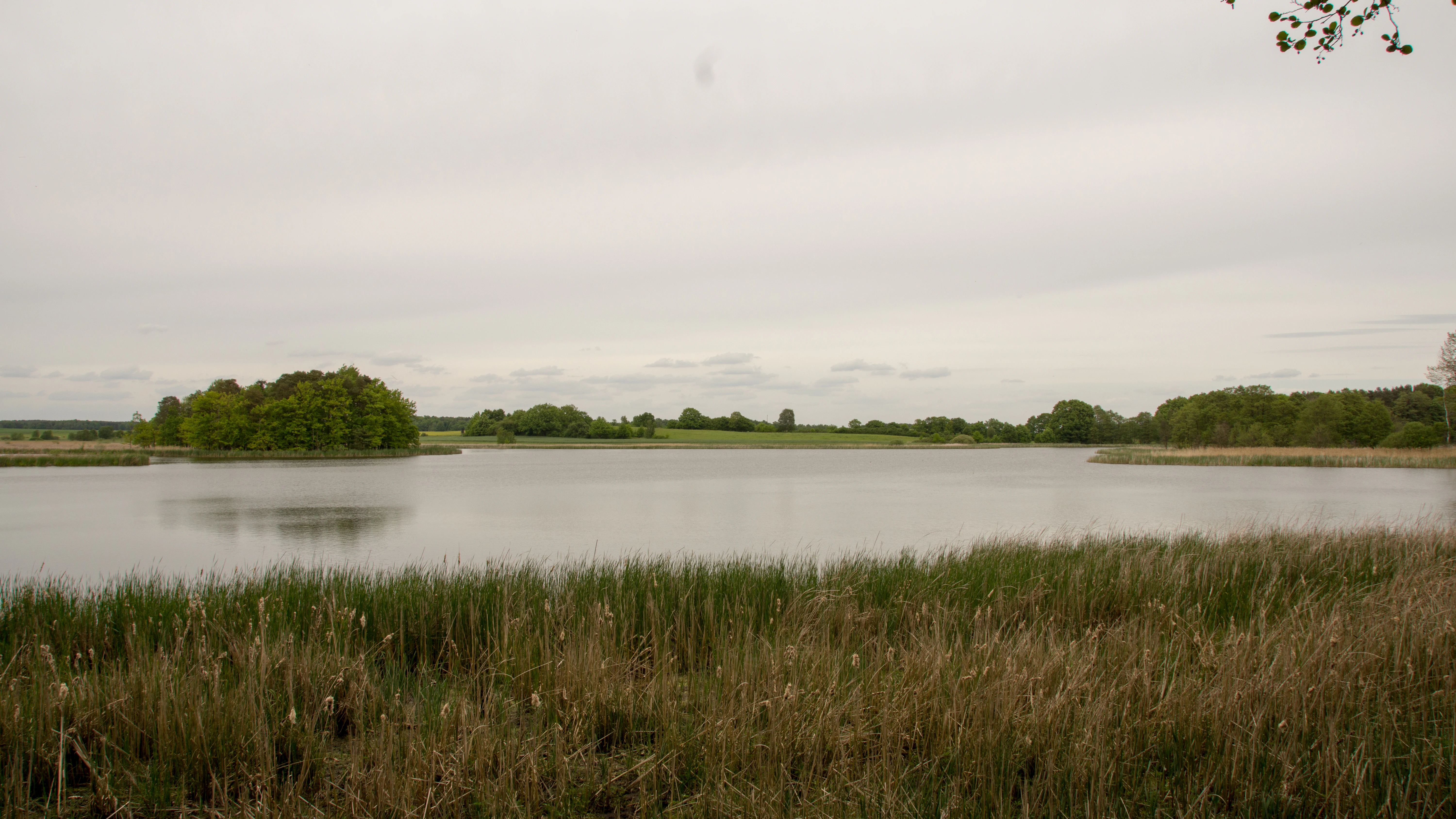
A wide, eye-level shot of a tranquil pond in the Frauenteich Moritzburg nature reserve, with dense reed beds in the foreground and patches of lush green trees on the distant banks under a cloudy sky.
A view across the Frauenteich pond within the Moritzburg nature reserve.

Frauenteich Moritzburg Nature Reserve history and protected-area timeline

The Frauenteich itself is a centuries-old element of the Moritzburg pond landscape, originally created as part of a system of fish ponds and game reserves serving the Saxon court. An old drystone wall that runs roughly parallel to the southern shore of the pond through the southern part of the reserve marks the former enclosure of the Alte Tiergarten, an old hunting ground associated with the Moritzburg Wildgehege. This wall now serves as a valuable habitat for mosses and lichens and is documented as part of the protected cultural landscape of Moritzburg.

Formal nature conservation began on 1 September 1954, when the area was first designated as a nature reserve to restrict human activities and protect its ecological values. Over the following decades, several refining ordinances were issued, including an enlargement on 23 June 1983 and a new regulatory ordinance from the Dresden Regional Government Office on 15 December 1999. A further amendment on 13 April 2007 completed the modern legal framework still in force today, while the area also became part of the surrounding Moritzburger Kleinkuppenlandschaft and Friedewald landscape protection areas.

A major conservation milestone was the formal separation of the Moritzburg Frauenteich area from the surrounding landscape protection area and its inclusion in the European Union's Natura 2000 network through designation as a European Bird Protection Area. The same ornithological significance earned the area Important Bird Area status, recognizing its value to breeding, feeding, roosting, and moulting waterbirds well beyond Saxony's borders.

Frauenteich Moritzburg Nature Reserve landscape and geographic character

The reserve's landscape is defined by the contrast between open water and gently undulating dry land. The dominant feature is the broad, shallow Frauenteich, whose flat water surface sits at around 160 to 171 meters above sea level and forms a large mirror within a partly wooded, partly open setting. Beyond the immediate shoreline, the terrain rises into low glacial hillocks, with the Winkelberg in the northwest rising about 12 meters above the water and standing as the highest point in the protected area.

These hillocks are the surface expression of a complex Pleistocene history. Glaciers of the Elster cold stage gouged out basins and rounded resistant rock into the low domes that now give the area its gently rolling character. During the Saale complex, meltwaters deposited outwash sands that smoothed parts of the landscape, and later glaciations, along with Holocene stream activity, continued to rework the surface. Today, sandy and gritty substrates dominate the hilltops and their flanks, while groundwater-influenced gley and pseudogley soils encircle the ponds.

The visual composition is one of open, often reed-fringed water, narrow bands of wet meadow and sedge, and patches of birch-oak woodland climbing the slopes of the small hills. The result is a peaceful, mosaic-like scene in which the reservoir of wetland habitat is framed by quiet, wooded ridges, a landscape character strongly tied to the broader Moritzburg pond country that extends around it.
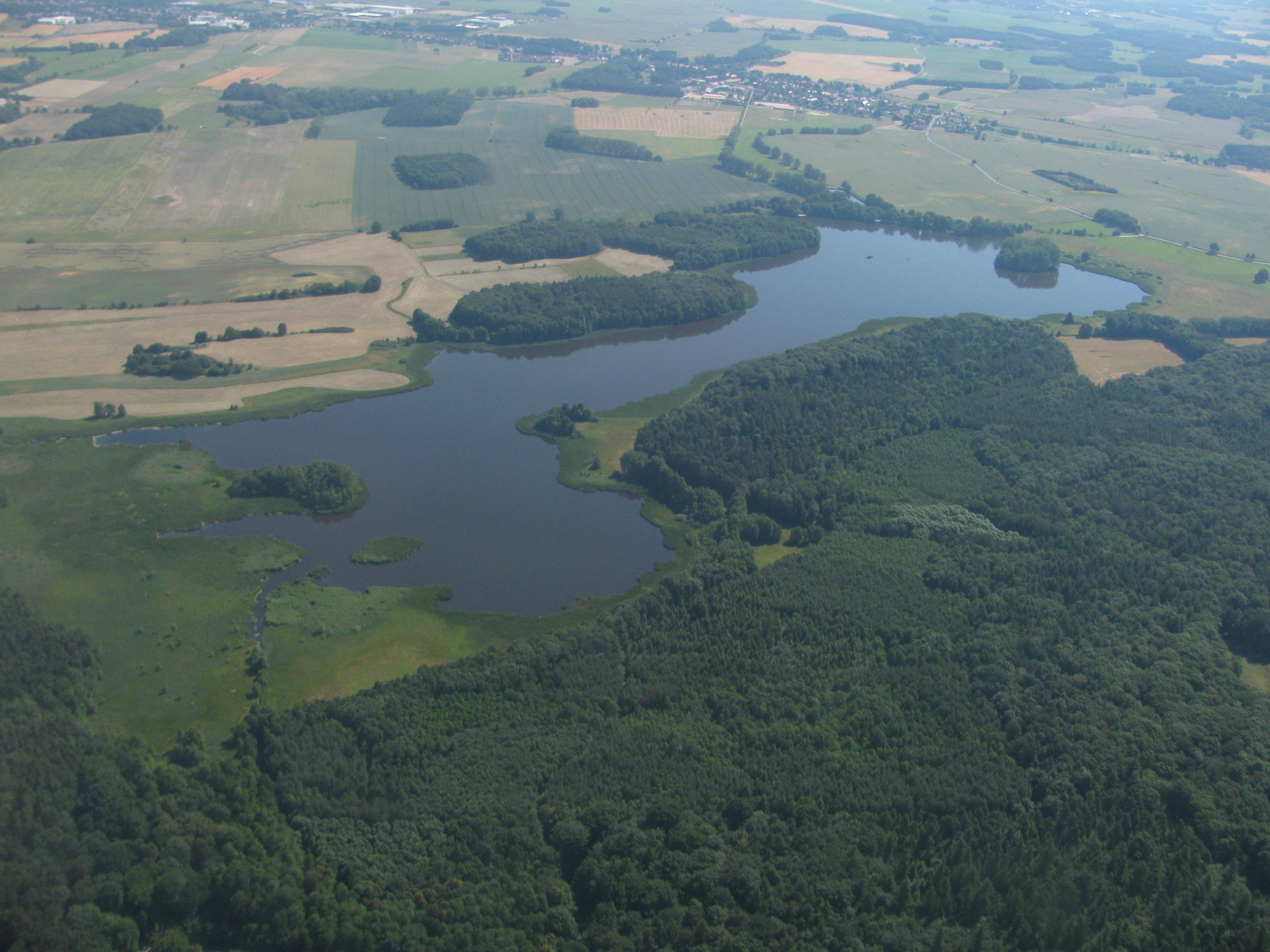
An aerial view showing the Frauenteich pond surrounded by forests and agricultural fields.
Aerial view of the Frauenteich nature reserve in Moritzburg, Germany.

Frauenteich Moritzburg Nature Reserve ecosystems, habitats, and plant life

The reserve's ecological character is shaped by the way its pond, marsh, and terrestrial habitats grade into one another. The Frauenteich itself is a nutrient-rich, eutrophic body of water with a particularly well-developed zonation of aquatic and wetland vegetation. Its open water is populated by common water buttercup and amphibious bistort, with reed communities of broad-leaved and narrow-leaved cattail, frogbit, and several duckweed species forming the floating and emergent layers. Beyond the reeds, large and then small sedge communities take over, eventually transitioning into Molinia grasslands in which compact rush and devil's-bit scabious thrive.

The terrestrial habitats in the reserve are equally diverse. Forests range from planted coniferous and broadleaf stands to birch-oak woodland that climbs the small glacial domes, while the natural vegetation on these slopes would originally have been oak-beech forest. Grassland in and around the reserve includes intensive meadows, tall oat-grass meadows, moist meadows, and creeping flood-meadows, giving a layered mosaic of open habitats. Soils range from sandy podzolic brown earths on the dry hilltops to groundwater-influenced gley soils and even localized low-moor gley around the water's edge, where a sapropel-like mud has begun to accumulate on the pond bottom.

Botanically, the reserve is unusually rich for its size. Some 293 vascular plant species, 47 mosses, 108 fungi, and 17 lichens have been recorded. Among the more notable plants are several nationally protected or threatened aquatic species, including water hottonia, water hemlock, and the endangered strauss-flowered yellow loosestrife, while mass occurrences of the nationally threatened greater bladderwort occur in the water itself. Around the Schösserteich, rare pondweed populations add to the area's botanical importance. The combination of dry sandy ridges, wet meadows, and nutrient-rich water on such a small footprint is the foundation of the reserve's biodiversity.

Frauenteich Moritzburg Nature Reserve wildlife and species highlights

The reserve's wildlife value is dominated by birds, with more than 190 species recorded overall, roughly half of them breeding locally. Historically even richer, with a 1957 inventory listing as many as 222 bird species at the Frauenteich, the area still functions as a regionally significant breeding, feeding, roosting, and moulting site for waterbirds and reed-dwelling passerines.

Species of particular note include water rail, great reed warbler, lapwing, and occasional bitterns, while all four native grebe species, great crested, red-necked, black-necked, and little grebe, can be observed on the open water. The reserve also supports open-country species such as the increasingly rare partridge, barred warbler, and whinchat, alongside woodland raptors and woodpeckers in the surrounding forests. A former laughing gull breeding colony on the pond died out in the late 1990s, reflecting the dynamic nature of waterbird populations on eutrophic waters.

Beyond birds, at least 31 mammal species have been recorded as breeding around the Frauenteich, including mustelids and several bat species. Invertebrate life includes noteworthy species such as the wetland-associated shamrock orb-weaver spider and the great green bush-cricket, both documented in the meadows and reed margins. The result is an unusually complete small-scale wetland ecosystem, where reptiles, amphibians, and insects all contribute to a functioning predator-prey and nutrient-cycling network.

Frauenteich Moritzburg Nature Reserve conservation status and protection priorities

The reserve's conservation role is substantial despite its modest size. It has been a formally protected Saxon nature reserve since 1954 and has been progressively refined through ordinances in 1983, 1999, and 2007, with the current legal baseline established by the Dresden Regional Government Office. Its protected status restricts damaging human activities and effectively excludes it from ordinary economic use, allowing natural processes to dominate.

The site is integrated into a layered system of protection. It is part of both the Moritzburger Kleinkuppenlandschaft and the Friedewald, Moritzburger Teichgebiet und Lößnitz landscape protection areas, which buffer the core area and maintain the wider pond landscape's traditional openness. Internationally, the area has been designated as a European Bird Protection Area under the EU Birds Directive and incorporated into the Natura 2000 network. It also carries formal Important Bird Area recognition, an acknowledgment of its exceptional ornithological value.

The focus of conservation management is habitat preservation rather than active intervention. The eutrophic pond, its layered reed and sedge margins, the wet meadows, and the dry birch-oak woodland ridges are all left to function with minimal disturbance, while the broader landscape protection zones help maintain the hydrological balance that keeps the pond landscape intact. This combination of long-term protection, international recognition, and richly developed wetland zonation makes the reserve a small but high-value node in Saxony's ecological network.

Frauenteich Moritzburg Nature Reserve cultural meaning and human context

The Frauenteich has long been part of the cultural landscape of Moritzburg, a region shaped by centuries of Saxon court hunting and fish-pond management. The drystone wall that runs through the southern part of the reserve marks the boundary of the former Alte Tiergarten, the old hunting enclosure associated with the Moritzburg Wildgehege, and is recognized as part of the protected cultural landscape of Moritzburg. The wall is itself a conservation feature, supporting a rich community of mosses and lichens.

Connected with Schloss Moritzburg and the wider Moritzburg pond landscape, the reserve sits within an area whose identity is tied to Saxon aristocratic landscape design and traditional fish farming. The surrounding villages of Moritzburg, Radeburg, Berbisdorf, Bärnsdorf, and Bärwalde have lived alongside this pond landscape for generations, and the modern designation as a nature reserve reflects a long evolution from productive pond use to protective conservation.

Top sights and standout views in Frauenteich Moritzburg Nature Reserve

A textbook example of eutrophic pond zonation, with a full sequence from open water and reed beds through large and small sedge communities to wet grassland, all within a compact footprint.

An internationally recognized wetland that is part of the European Natura 2000 network, designated as a European Bird Protection Area and listed as an Important Bird Area for its more than 190 recorded bird species.

A glacial landscape where Pleistocene processes left a patchwork of sandy ridges, gley soils, and pond basins, producing unusually close coexistence of dry birch-oak woodland and wet meadows.

Best time to visit Frauenteich Moritzburg Nature Reserve

The reserve's character varies through the seasons in the way typical of Central European pond landscapes. Spring and early summer are the most rewarding periods for visiting ornithologists and casual observers, when the reed margins and wet meadows host breeding waterbirds and passerines, and when the vegetation of the open water and shoreline is at its most lush.

Late summer and autumn bring their own appeal, with fruiting fungi in the birch-oak forests, mature reed stands along the pond margins, and the return migration of waterbirds to the open water, while the drystone wall and ridge paths remain attractive for walking year-round. Winter visit potential is more limited but still offers quiet, reflective views across the unfrozen sections of the pond and the surrounding wooded ridges.

Monthly climate preview

Long-term monthly temperature and precipitation data recorded at a representative park coordinate

Frauenteich Moritzburg Climate Normals and Annual Temperature Rhythm

Historical climate records for Frauenteich Moritzburg establish a measured annual progression of average temperatures and daily precipitation rates across the representative coordinate. Detailed twelve-month datasets supply comprehensive monthly temperature ranges and moisture distribution patterns for further geographic analysis.
Annual mean8 °C
-2 °C19 °C
Jan-2°
Feb-1°
Mar
Apr
May13°
Jun17°
Jul19°
Aug19°
Sep14°
Oct
Nov
Dec-1°
Warmest month
July

19.1 °C

Coolest month
January

-1.8 °C

Wettest month
July

2.8 mm/day

Driest month
April

1.3 mm/day

Park location guide

Geography guide, regional context, and park location map for Frauenteich Moritzburg Nature Reserve

Frauenteich Moritzburg Nature Reserve park geography, regions, and map view in Germany

Understand where Frauenteich Moritzburg Nature Reserve sits in Germany through a broader geographic reading of the surrounding landscape, nearby location context, and its mapped position within the national park landscape.

How Frauenteich Moritzburg Nature Reserve fits into Germany

Germany is a federal republic in Western and Central Europe with a population of over 83 million across sixteen constituent states. It is Europe's largest economy by nominal GDP and a major global exporter and importer. The capital is Berlin, and the country borders Denmark, Poland, Czech Republic, Austria, Switzerland, France, Luxembourg, Belgium, and the Netherlands.

Wider geography shaping Frauenteich Moritzburg Nature Reserve in Germany

Germany is located in Western and Central Europe, spanning 357,022 km². It borders Denmark to the north, Poland and the Czech Republic to the east, Austria and Switzerland to the south, and France, Luxembourg, Belgium, and the Netherlands to the west. The country has coastlines on the Baltic Sea and North Sea to the north, with the Alps located in the southern region.

Map view of Frauenteich Moritzburg Nature Reserve

Use this park location map to pinpoint Frauenteich Moritzburg Nature Reserve in Germany, understand its exact geographic position, and read its mapped placement within the surrounding landscape more clearly.

Pigeon | © OpenStreetMap contributors

Location context for Frauenteich Moritzburg Nature Reserve

Meißen DistrictSaxony

Visual reference of wetland habitats, reed belts, and glacial pond terrain

Frauenteich Moritzburg Photos, Landscape Scenery, and Protected Area Views

Visual documentation reveals the distinctive wetland zoning, shallow open waters, and shoreline reed belts defining the nature reserve. Detailed photography of the protected landscape illustrates the ecological mosaic of birch-oak woodlands and wet meadows surrounding the water basins.

A wide, eye-level shot of a tranquil pond in the Frauenteich Moritzburg nature reserve, with dense reed beds in the foreground and patches of lush green trees on the distant banks under a cloudy sky.

Two grey birds foraging in a grassy field in front of a line of trees and a pond.

An aerial view showing the Frauenteich pond surrounded by forests and agricultural fields.

Park atlas

Compare nearby wetland reserves and connected landscapes across the regional pond country

Explore Parks Near Frauenteich Moritzburg and Surrounding Regional Protected Areas

Discover protected areas and wildlife habitats located near Frauenteich Moritzburg to evaluate regional environmental gradients. Comparing adjacent nature reserves provides deeper context on glacial pond terrain and wetland bird sanctuaries across Saxony.
A horizontal watercolor illustration showing a calm pond in the foreground, with lush green vegetation on the banks and rolling hills in the background under a soft sky.
Nature reserveMeißen
About 4.8 km away#1 closest

Southwest

Dippelsdorfer Teich Nature Reserve: Geographic Insights and Landscape Context

Historic Saxon pond management and regional protected landscape.

The Dippelsdorfer Teich serves as a primary example of historical pond construction and nature protection in the northern Dresden countryside. This 69 hectare reservoir captures a blend of ecological, cultural, and recreational values within the Meißen region. Users can examine its physical layout, the dam structure, and the integration of heritage transport within this managed lowland environment.

Area
0.69 km²
Established
1528
Relief
Lowland
Scope
Terrestrial
Nature reserveSachsen
About 6.7 km away#2 closest

Northeast

Waldmoore bei Großdittmannsdorf: A Protected Wetland Landscape in Sachsen, Germany

Mapping forest mires and rare swamp woodland habitats

Waldmoore bei Großdittmannsdorf represents a carefully maintained nature reserve in eastern Germany, spanning roughly 93 hectares of forest mire and bog structures. The site supports a rare transition of swamp woodland, sedge-rich wet stands, and spring flushes within the Laußnitzer Heide. As a designated Natura 2000 area, it plays a key role in safeguarding regional wetland connectivity and providing a refuge for specialist flora and fauna in the Saxon landscape.

Area
0.935 km²
Established
2000
IUCN
IV
A pale, soft watercolor painting depicting a small arched bridge crossing a gentle stream within a rolling green valley.
Protected landscapeSaxony
About 14 km away#3 closest

East

Seifersdorfer Tal Protected Landscape and Cultural Heritage in Saxony

A historic garden monument and river valley ecosystem

The Seifersdorfer Tal is a protected landscape defining the Große Röder valley. Beyond its cultural status as one of Germany's earliest English-style landscape gardens, the area serves as a vital riverine corridor and nature reserve. The terrain offers a unique blend of rocky outcrops, wooded slopes, and meadows linked by historic footpaths and 18th-century allegorical monuments.

Area
2.88 km²
Established
1960
Relief
Upland
Climate
Temperate
Nature reserveSachsen
About 15 km away#4 closest

West

Winzerwiese und Gosebruch: Protected Nature Reserve and Valley Geography in Sachsen

Mapping protected wet meadows and floodplain woodlands

Winzerwiese und Gosebruch is a distinctive nature reserve in Sachsen, Germany, centered on a small valley along the Gosebach stream. This protected area creates a dense mosaic of wet meadow, marshy woodland, and dry deciduous forest, offering a significant look at the region's diverse botanical landscape and river-valley geography.

Area
0.116 km²
Established
1967
IUCN
IV
A soft, light-toned watercolor painting of a low, rolling landscape with green hills, sparse vegetation, and a suggestion of wetland or pond in the foreground.
Nature reserveSachsen
About 19 km away#5 closest

West

Seußlitzer und Gauernitzer Gründe: Protected Nature Reserve Map and Landscape Overview

Regional geography and habitat boundaries in the Sachsen Elbe valley.

Spanning steep slopes and narrow brook valleys on both sides of the Elbe, Seußlitzer und Gauernitzer Gründe is a defining nature reserve in Sachsen. This protected area supports a diverse mix of dry herbaceous vegetation and mature deciduous forest, serving as a critical component of the local ecological network within the broader Upper Elbe landscape.

Area
3.57 km²
Established
2013
IUCN
IV
Relief
Upland
Watercolor painting of a soft landscape featuring distant hills and foreground vegetation in shades of green, yellow, and soft red.
Nature reserveSachsen
About 21 km away#6 closest

Southeast

Dresdner Elbtalhänge Nature Reserve: Geography, Mapped Boundaries, and Landscape Context

An essential nature reserve along the Elbe valley in Sachsen

Dresdner Elbtalhänge captures the striking transition between the flat Elbe floodplain and the Westlausitz hill region. This detailed atlas entry covers the reserve's unique geomorphology, including its incised ravine systems, south-facing oak forests, and exposed rock formations that define its protected character within Sachsen.

Area
203.6 km²
Established
2007
IUCN
IV
Nature reserveFreistaat Sachsen
About 21 km away#7 closest

South

Windberg Nature Reserve: Mapping the Forested Ridge and Protected Landscape of Saxony

Geology, mining heritage, and protected oak-beech forest ecosystems

Windberg serves as the prominent local landmark for Freital, defined by its elongated forested plateau and complex tectonic geography. This nature reserve offers a study in the intersection of environmental conservation and human industrial history, featuring Saxony's deepest cave and varied habitats within the eastern Ore Mountains foothills.

Established
1967
Relief
Mountain
Climate
Temperate
Access
Easy access
A pale, soft watercolor illustration showing a horizontal landscape of light green trees, shrubs, and rolling grassy plains on a white background.
Nature reserveGermany
About 23 km away#8 closest

Southeast

Elbinseln Pillnitz und Gauernitz: A Study in Protected Saxon River Landscapes

Examining floodplain geography and rare river island ecosystems

Located in the Elbe valley between Dresden and Meissen, Elbinseln Pillnitz und Gauernitz preserves the final natural river islands within the state of Saxony. This protected nature reserve anchors a vital network of alluvial soils, riparian woodlands, and unarmored riverbanks, offering a unique perspective on the dynamic floodplain geography of Germany's major river corridors.

Area
0.235 km²
Established
2006
IUCN
IV
Relief
Lowland

Common questions about visiting, size, designation, and location context for Frauenteich Moritzburg Nature Reserve

Frauenteich Moritzburg Nature Reserve FAQs for park facts, access, geography, and protected area context

Find quick answers about Frauenteich Moritzburg Nature Reserve, including protected-area facts, park geography, trail and visitor context, and how the park fits into its surrounding country and regional landscape.
MoriAtlas Explorer

Continue Your Protected Areas Search Across the Global Atlas

Deepen your exploration by continuing the structured search for national parks and protected areas worldwide. Utilize the comprehensive filtering capabilities to compare different conservation landscapes and refine your understanding of global park geography. Discover more about the distribution and characteristics of protected natural areas.

Global natural geography