
Mori Atlas logo
Nature reserveGemenc

A dynamic freshwater landscape shaped by the seasonal rhythms of the Danube river basin

Gemenc Nature Reserve, Mapping the Expansive Alluvial Floodplain Forest of Southern Hungary

Gemenc represents one of the most significant protected floodplain forests in Europe, situated as a sprawling alluvial corridor in southern Hungary. This nature reserve features a complex mosaic of willow and poplar stands near the river channels, transitioning into dense oak-ash-elm forests across higher ground. Through the lens of this map-based atlas, observe the intricate network of oxbow lakes, river islands, and protected wetland habitats that remain subject to the natural flooding regime of the Danube.

floodplain forestalluvial woodlandDanubeDanube-Drava National ParkRamsar Wetlandtidal freshwater forest
A digital illustration of a winding river flowing through a flat valley between low rolling hills, framed by dark silhouettes of trees in the foreground.

Gemenc

Nature reserve

Park overview

Structured park overview, official facts, and landscape profile for Gemenc

Gemenc park facts, protected area profile, and essential visitor context

Review the core facts for Gemenc, including designation, size, terrain, visitor scale, habitats, and operating context in one park-focused overview.

About Gemenc

Gemenc occupies one of the most distinctive stretches of the Hungarian Danube, where the river's gradient is so gentle that it still spreads freely across an extensive floodplain rather than being locked between rigid embankments. Covering about 180 square kilometers of regularly inundated floodplain, the reserve is one of the largest contiguous alluvial forests in Hungary and one of the very few in Europe where such large-scale tidal freshwater woodland dynamics still operate. The terrain forms a 5 to 10 kilometer wide band, generally 5 to 7 kilometers across, running south from the confluence of the Sió and Sárvíz rivers near Szekszárd and Bogyiszló down to Báta and Bátmonostor.

Administratively, the area is mostly within Tolna County with a smaller portion in Bács-Kiskun County, and geographically it forms part of the traditional Sárköz region. The Danube here separates into multiple branches past numerous islands, including Veránka-sziget, Kádár-sziget, and Nagy-Pandúr-sziget, and leaves behind a network of oxbow lakes such as the Gemenci Holt-Duna, the Decsi Nagy-Holt-Duna, the Rezéti Holt-Duna, and others further south. These still waters and the changing floodwater levels create the hydrological conditions that support Gemenc's specialized vegetation and animal communities.

Since 1977 the area has been officially recognized as a nature reserve and it now forms part of the broader Danube-Drava National Park, receiving additional international recognition as a Ramsar Wetland in 1997. Forest and game management on state land is carried out by the company Gemenc Erdő- és Vadgazdaság Zrt., which balances timber and wildlife use with flood protection duties along this stretch of the Danube. Above all, Gemenc is defined by the continuing interplay between river, forest, and flood, a quality that makes it both ecologically exceptional and visually memorable for those exploring the southern Hungarian Danube.

Quick facts and research context for Gemenc

Gemenc is a floodplain forest reserve along the Hungarian Danube, situated between Szekszárd and Baja in the southern part of the country. Established as a protected area in 1977, it now belongs to the Danube-Drava National Park and is overseen by the Danube-Drava National Park Directorate. The forest is reached in a band roughly 5 to 10 kilometers wide along the river, and much of its terrain is still naturally shaped by Danube flooding, making it a rare surviving example of tidal freshwater woodland in Europe. The site also carries Ramsar Wetland recognition, designated in 1997, reflecting its international significance as a wetland habitat.

Protection and recognition

Documented terrestrial protection history, Ramsar listing, and Natura 2000 designations

Gemenc Protection Status and International Recognition Data

Gemenc maintains recorded terrestrial protection status established in 1997 alongside official Ramsar and Natura 2000 international recognitions. Documented management scope and conservation listings provide structured baseline data for this protected area.
Park context

Deeper park guide and search-rich context for Gemenc

Gemenc history, landscape, wildlife, and travel context

Explore Gemenc through its history, landscape character, ecosystems, wildlife, conservation priorities, cultural context, and seasonal travel timing in a structured park guide built for atlas discovery and search intent.

Why Gemenc stands out

Gemenc is best known for being Hungary's last remaining tidal freshwater forest, an alluvial woodland where the Danube still regularly floods large tracts of land and reworks the landscape. The reserve's red deer population is internationally renowned for the outstanding quality of its antlers and genetic stock, with trophy specimens historically sought by hunters from across Europe. The forest also supports an unusually rich birdlife, including white-tailed eagles, saker falcons, black storks, heron colonies, and black kites, set against a backdrop of willow-poplar and oak-ash-elm forests intersected by oxbows and river islands.
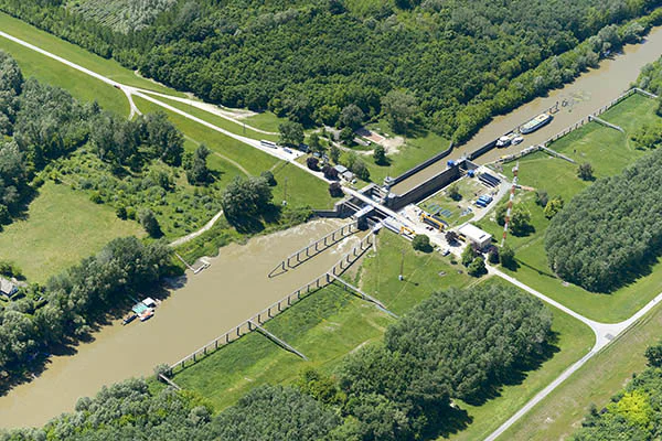
Aerial view of a canal lock system surrounded by dense forest and green embankments.
Aerial view of the Keselyus shipping lock on the Sio Canal in the Gemenc region.

Gemenc history and protected-area timeline

Gemenc has been shaped by centuries of interaction between the Danube and the people who lived along its banks, but its modern identity as a protected area begins in the twentieth century. Before that, the broader Sárköz region was historically dominated by the Kalocsa Archbishopric's estate system, which managed forests and hunting grounds here from the late 1700s through 1945. The 1953 Hungarian nature documentary film "Gyöngyvirágtól lombhullásig" ("From Blossom Time to Autumn Frost"), directed by István Homoki Nagy, brought Gemenc's wildlife to public attention through vignettes filmed across the seasons.

The forest's modern institutional history begins with the creation of state-managed forestry and game operations in the mid-twentieth century, when the Dunaártéri Állami Erdőgazdaság and the Gemenci Állami Vadgazdaság merged in 1968 to form the Gemenci Állami Erdő- és Vadgazdaság. In 1977 Gemenc itself received formal nature reserve status, cementing its conservation status amid a wider movement to protect Hungary's floodplain ecosystems. In 1993 the state forestry entity was reorganized into the modern Gemenc Erdő- és Vadgazdaság Zrt., which continues to manage forest and wildlife operations across a much broader estate than the strictly protected core.

In 1997 Gemenc received international recognition as a Ramsar Wetland, highlighting the global importance of its periodically flooded habitat. As the wider national park system evolved, Gemenc was incorporated into the Danube-Drava National Park, confirmed as part of one of Hungary's flagship conservation landscapes, with the Danube-Drava National Park Directorate taking over overall stewardship of the reserve.

Gemenc landscape and geographic character

Gemenc is fundamentally a floodplain landscape. The Danube here runs through a very gentle gradient, causing it to slow and spread across a wide alluvial belt rather than cutting a single deep channel. The forested area forms a roughly 30 kilometer long strip averaging 5 to 7 kilometers in width, sometimes reaching 10 kilometers, between the river and the higher embankments of the flood protection system. This makes the area one of the most extensive intact floodplain forests in Hungary.

The terrain is defined by its water features. A network of oxbows reflects the Danube's meandering past, including the Gemenci Holt-Duna, the Decsi Nagy-Holt-Duna, the Rezéti Holt-Duna, the Forgó-tó, the Sulymos-tó, and others, alongside still-active branches that flow past named islands such as Veránka-sziget, Kádár-sziget, and Nagy-Pandúr-sziget. Between 1810 and 1872, extensive river regulation works along the right bank changed how the floodplain evolved, accelerating natural silting of older oxbows while limiting the formation of new ones; however, the right-bank alluvial forest between Keselyűs and Báta still periodically floods in its natural state within the dike-and-bed-protected area.

The 1968 to 1974 construction of the Keselyűsi torkolati zsilip (officially Sió-Árvízkapu), southeast of Bogyiszló, added a major piece of flood-management infrastructure to the landscape. The Sió canal enters the Danube here, an important hydrological feature for the broader region. Beyond the forests themselves, the setting includes the settlements and micro-region of Sárköz, with Pörböly, Báta, Bogyiszló, Dusnok, and Bátmonostor framing the edges of this otherwise densely wooded floodplain.
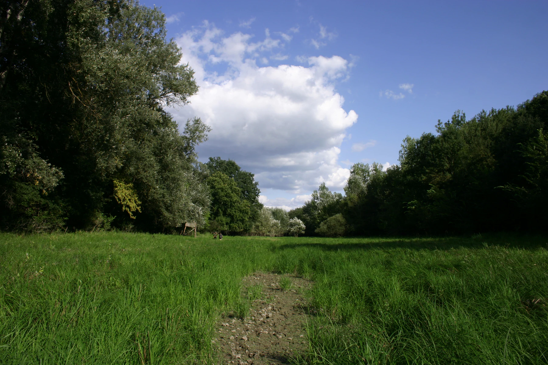
A wide shot of a green grassy clearing centered between two thick lines of trees under a blue sky with white clouds.
A lush green meadow surrounded by dense forest in the Gemenc region of Hungary.

Gemenc ecosystems, habitats, and plant life

Gemenc is the largest predominantly forested floodplain in Hungary, and its vegetation is closely tied to the rhythm of Danube flooding. The dominant trees are willows, which occupy the lowest, most frequently inundated areas, while poplars take over slightly higher ground. Further inland, on elevations less prone to regular flooding, mature oak-ash-elm forests spread across the broader forest interior. Within this gradation from wet willow-poplar stands to upland hardwood forest, the floodplain exhibits clear vegetation zones that directly reflect water depth and frequency of inundation.

The shrub layer of these alluvial forests is unusually rich, characterized by hawthorn and dewberry, which together form such dense, tangled vegetation that the forests are largely impenetrable on foot. This thick understory provides crucial cover for the area's large mammal populations. On higher terraces that flood less often, the rare black hawthorn can be found, and the spring snowflake is characteristic of the herb layer beneath the trees.

Oxbows, abandoned channels, river islands, and the slow-moving branches of the Danube itself add wetland and aquatic habitat to the closed-canopy forest. The diversity of these water-related environments supports an exceptional range of amphibian, reptile, and fish life, complementing the woodland habitats. Together, the forest, the open water bodies, and the periodically flooded meadows create a multi-layered alluvial ecosystem that is rarely matched elsewhere in Central Europe.
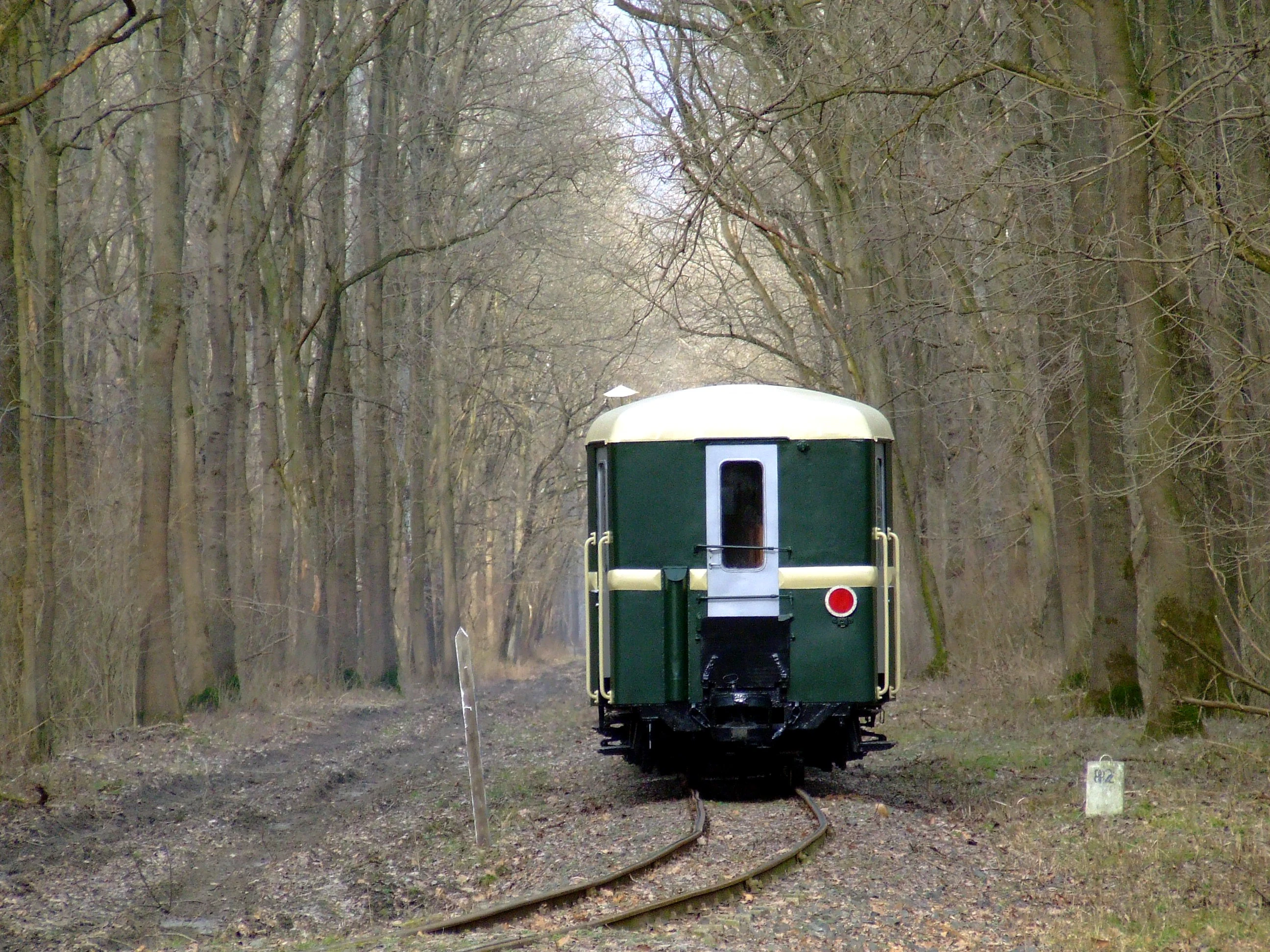
A green and cream colored narrow gauge passenger carriage on tracks traveling through a dense, leafless forest.
The Gemenc State Forest Railway winding through the dense woodland of the Gemenc forest.

Gemenc wildlife and species highlights

Despite being managed partly as a working forest, Gemenc supports one of Hungary's most diverse wildlife communities, owing to the unbroken transition from aquatic to woodland habitats. The area's large mammal populations are particularly notable. Red deer are the area's most famous residents, prized for the size of their antlers and the quality of their genetic stock; their population has given Gemenc a long-standing international reputation in hunting circles. Roe deer and wild boar are also abundant, roaming the same willow-poplar and oak-ash-elm forests that conceal them.

The birdlife is equally rich. White-tailed eagles, saker falcons, lesser spotted eagles, and black kites nest in the area, along with numerous heron colonies where grey herons are especially numerous. Black storks also breed here, while the floodplain's mosaic of channels and oxbows provides habitat for storks in general and many wading species. Wetland margins and meadow edges host amphibians and reptiles in significant numbers, and the slow-moving arms of the Danube support diverse fish communities.

In the invertebrate realm, Gemenc is just as distinctive. Thirteen protected butterfly species have been recorded, including the Freyer's purple emperor (in Hungarian "Magyar színjátszólepke"). The forests also host stag beetles, the great capricorn beetle, and a spider species found only in this area. The combination of large predators, ungulates, breeding raptors, colonial waterbirds, and rare invertebrates makes the reserve an unusually rich site for wildlife observation, particularly along its quieter oxbow shorelines.
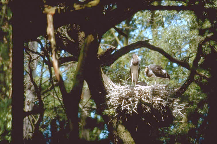
Two black storks standing inside a large stick nest located in the fork of a tall tree, surrounded by dense green foliage.
Two black storks standing in a nest high in the canopy of the Gemenc floodplain forest.

Gemenc conservation status and protection priorities

Gemenc's conservation importance lies in the persistence of natural flooding dynamics within a large forest landscape, a feature that has been lost from most of Europe's great rivers. Following centuries of channelization on the Danube, only a handful of floodplain stretches still receive their natural flood pulse on this scale, and Gemenc ranks among the most significant for Hungary and for the Danube basin as a whole. This hydrological character was central to its inclusion among globally important wetlands when it was designated a Ramsar Wetland in 1997.

Domestically, the area's protection rests on its 1977 nature reserve status and its incorporation into the Danube-Drava National Park, with overall stewardship provided by the Danube-Drava National Park Directorate. The strict core of the reserve covers a meaningful portion of the broader territory and excludes hunting and forestry, while surrounding lands continue to be managed for timber, game, and flood protection by the state forestry company. This dual structure of strict protection within a working landscape is itself an important conservation approach, allowing floodplain function to be preserved at a scale that pure strict reserves rarely cover.

The site's ecological value is unusually broad, encompassing mature hardwood floodplain forest, dynamic riverine habitat, oxbow lake systems, and a rich mosaic of breeding sites for European raptors and herons. The continued presence of species such as white-tailed eagle, saker falcon, black stork, and red deer with notable genetic quality highlights the reserve's role in maintaining populations that have declined elsewhere. Conservation of the area is also a question of water management, as the periodic floods that shape its forests are simultaneously an ecological asset and a logistical challenge that continues to require active management along this section of the Danube.

Gemenc cultural meaning and human context

Gemenc lies within the Sárköz, a historical micro-region on the Hungarian Danube that long retained a distinctive rural and folk culture shaped by the river. The forests and hunting grounds of this area were historically tied to the Kalocsa Archbishopric's estates, whose forest and game management practices shaped local land use from the late 1700s until 1945. Archbishopric hunting lodges in and around the area reflect this older cultural layer.

Twentieth-century nature film played a notable role in shaping public awareness of the forest. The 1953 Hungarian nature documentary "Gyöngyvirágtól lombhullásig" ("From Blossom Time to Autumn Frost"), made by István Homoki Nagy, presented the forest's wildlife to viewers and helped anchor Gemenc in Hungary's broader cultural understanding of its natural landscape. Today, the small forest railway, the network of educational nature trails, and visitor centers near Pörböly connect contemporary visitors to both the working forestry heritage and the conservation identity of the area.

Top sights and standout views in Gemenc

Hungary's largest remaining tidal floodplain forest, where the Danube still naturally reworks the land on a substantial scale.

A globally recognized Ramsar Wetland site and part of the Danube-Drava National Park, set aside for protection in 1977.

Famous for red deer of exceptional antler quality and notable genetic stock, alongside abundant wild boar and roe deer.

A rich breeding ground for white-tailed eagles, saker falcons, black storks, lesser spotted eagles, and large grey heron colonies.

A distinctive vegetation mosaic of willow-poplar forests along the water and oak-ash-elm forests inland, interspersed with oxbow lakes and river islands.

Rare invertebrate residents including thirteen protected butterfly species, the Freyer's purple emperor, stag beetles, and a spider species found only at Gemenc.

Best time to visit Gemenc

Gemenc's character shifts strongly with the seasons and with the rhythm of the Danube floods. Spring brings fresh green foliage and active birdlife, when black storks and heron colonies are establishing their breeding season and amphibian activity is at its peak. Summer is the most visually lush period for the floodplain forests, with denser foliage, higher water levels, and active insect populations that make the woodlands especially rich.

Autumn is widely associated with the broader Hungarian conception of Gemenc, given its strong connections to the deer rutting season and to traditional hunting imagery in Hungarian nature writing. The 1953 film "Gyöngyvirágtól lombhullásig" frame its story around this seasonal arc, from spring blossom to autumn leaf fall. Winter, when the deciduous forests thin out, makes it easier to observe large mammals such as red deer and to read the floodplain's topography through its bare branches and exposed oxbow channels. Specific operational timings of forest trains or guided programs should be confirmed locally, as seasonal services may vary.
Monthly climate preview

Month by month average temperature and precipitation metrics for Gemenc

Gemenc Climate Normals, Long Term Temperature and Precipitation Patterns

Representative coordinate records reveal a measured annual temperature range spanning subzero winter lows to high summer maximums alongside consistent daily precipitation. Reviewing the complete twelve month profile clarifies long term climate rhythms across the protected landscape.
Annual mean11 °C
-1 °C23 °C
Jan-1°
Feb
Mar
Apr11°
May17°
Jun21°
Jul23°
Aug23°
Sep17°
Oct11°
Nov
Dec
Warmest month
July

23.2 °C

Coolest month
January

-1 °C

Wettest month
June

2.3 mm/day

Driest month
January

1.2 mm/day

Park location guide

Geography guide, regional context, and park location map for Gemenc

Gemenc park geography, regions, and map view in Hungary

Understand where Gemenc sits in Hungary through a broader geographic reading of the surrounding landscape, nearby location context, and its mapped position within the national park landscape.

How Gemenc fits into Hungary

Hungary is a landlocked Central European country occupying the Carpathian Basin, also known as the Pannonian Basin. It borders Slovakia, Ukraine, Romania, Serbia, Croatia, Slovenia, and Austria. Budapest serves as both the capital and largest city. The population is predominantly ethnic Hungarians (Magyars), with Hungarian as the official language.

Wider geography shaping Gemenc in Hungary

Hungary occupies the Carpathian Basin in Central Europe, a large lowland plain surrounded by the Carpathian Mountains. It is bordered by Slovakia to the north, Ukraine to the northeast, Romania to the east and southeast, Serbia to the south, Croatia and Slovenia to the southwest, and Austria to the west. The Danube River flows through the country, providing its primary drainage.

Map view of Gemenc

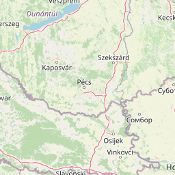
Use this park location map to pinpoint Gemenc in Hungary, understand its exact geographic position, and read its mapped placement within the surrounding landscape more clearly.

Pigeon | © OpenStreetMap contributors
Recorded earthquake history

Explore Historical Earthquake Records Associated with Gemenc

Access the comprehensive collection of seismic events recorded in the proximity of Gemenc. This resource allows for a detailed review of documented magnitude and epicenter location data, providing a useful spatial perspective on historical seismic patterns across this important Hungarian floodplain landscape.

Gemenc Earthquake History Records

Catalogued events

1 event

Strongest magnitude

Magnitude 4

Most recent event

May 5, 2026

This history includes earthquakes recorded inside the park or within 50 km of its borders

Explore the visual character, tidal freshwater forests, and alluvial terrain of Gemenc.

Gemenc Photos and Protected Landscape Scenery Visualized

Visual documentation of Gemenc reveals the intricate network of oxbow lakes, river islands, and dynamic alluvial woodlands shaped by the Danube. Examining these protected area environments provides a clearer understanding of the rare tidal freshwater forest habitats and diverse terrain.

Aerial view of a canal lock system surrounded by dense forest and green embankments.

A calm, muddy river branch winds through a dense green forest, viewed from under the shade of an overhanging tree branch.

A wide shot of a green grassy clearing centered between two thick lines of trees under a blue sky with white clouds.

A green and cream colored narrow gauge passenger carriage on tracks traveling through a dense, leafless forest.

Two black storks standing inside a large stick nest located in the fork of a tall tree, surrounded by dense green foliage.

Park atlas

Compare adjacent wetland reserves, river floodplains, and regional habitats

Exploring Parks Near Gemenc And Surrounding Protected Landscape Areas

Browsing parks near Gemenc opens up broader comparative views of southern Hungary protected landscapes, river corridors, and alluvial reserves. Extending your wildlife and floodplain habitat research across the surrounding region reveals connected ecological networks.
Watercolor illustration of a river landscape with grassy banks, trees, and hills in the background
National parkHungary
Mapped location lies within the park boundary#1 closest

Southwest

Danube-Drava National Park: Hungary's Premier Riverine Protected Area and Floodplain Landscape

Mapping the protected river corridors and vital wetland ecosystems

Danube-Drava National Park showcases the dynamic geography of Central Europe's largest riverine protected area, integrating floodplains, riparian woodlands, and extensive marshes along the Danube and Drava rivers. As a National Park and a Ramsar site, it protects crucial habitats like the Gemenc forest and supports exceptional biodiversity, including significant populations of white-tailed eagles. This page provides a structured overview of its mapped boundaries and ecological importance within the European protected lands atlas.

Area
490 km²
Established
1996
IUCN
II
Relief
Lowland
A horizontal watercolor illustration of a soft, green wetland landscape with rolling hills in the background and a winding river in the foreground.
Biosphere reserveCroatia
About 13 km away#2 closest

South

Mura-Drava-Danube Biosphere Reserve: Croatian Protected Area and River Landscape Atlas

Mapping transboundary river corridors and floodplain habitats

Mura-Drava-Danube represents a major transboundary biosphere reserve following the Mura, Drava, and Danube rivers. This protected area comprises a mosaic of active river channels, gravel islands, and seasonal wetlands that support internationally important populations of fish and birds. As a key ecological corridor in Central Europe, it maintains rare floodplain dynamics and riparian habitats that have largely vanished from other lowland river systems.

Area
6,314.61 km²
Established
2016
IUCN
IV
Relief
Lowland
Watercolor painting of rolling hills, green fields, and a winding path
National parkHungary
21 km away#3 closest

Northeast

Kiskunság National Park: Explore Hungary's Puszta Grassland and Unique Sand Dune Terrain

Discover protected landscapes, alkaline lakes, and bird habitats.

Kiskunság National Park in Hungary offers a rare glimpse into the traditional puszta grassland ecosystem, featuring dynamic sand dunes and numerous alkaline lakes. This protected area is vital for migratory bird populations and showcases a distinctive lowland geography shaped by natural processes and pastoral heritage. Explore its scattered territorial units to understand the unique landscape context of the Great Hungarian Plain.

Area
530 km²
Established
1975
IUCN
II
Relief
Lowland
Watercolor illustration of a river flowing through wetland vegetation with distant hills under a light sky
Protected landscapeOsijek-Baranja County
31 km away#4 closest

South

Kopački Rit Protected Landscape: A Key European Wetland Ecosystem in Osijek-Baranja County

Mapped natural terrain and protected landscape geography.

Delve into the protected landscape of Kopački Rit, a pivotal European wetland situated within Osijek-Baranja County, Croatia. This page offers a detailed look at its dynamic floodplain ecosystem, mapped water channels, marshes, and riparian forests, highlighting its importance for biodiversity and regional geography. Understand the park's extensive protected boundaries and its place in the broader continental atlas.

Area
177 km²
Established
1976
IUCN
V
Relief
Lowland
Watercolor illustration of a winding river through grassy fields with wildflowers and distant hills
Protected landscapeSerbia
About 59 km away#5 closest

East

Subotička Peščara Protected Landscape: A Mapped Inland Dune System in Serbia

Explore unique Pannonian Plain geography and rare habitats.

Subotička Peščara Protected Landscape offers a deep dive into an exceptional inland dune ecosystem, a key feature of Serbia's Pannonian Plain geography. This protected area's mapped terrain includes a mosaic of forest, steppe, and wetland habitats, supporting rare flora and fauna. Discover the unique contours of this aeolian landscape and its significance within the regional geographic context.

Area
53.7 km²
Established
2002
IUCN
V
Relief
Lowland
Watercolor illustration of Lake Palić showing a body of water with green and pink trees on the shore, rolling hills in the background
Protected areaSerbia
About 63 km away#6 closest

East

Lake Palić Protected Area: Serbia's Mapped Landscape and Regional Geography Exploration

Understand the protected landscape and park boundaries of Lake Palić.

Delve into the specifics of Lake Palić, a designated protected area in Serbia. This resource offers a deep dive into the park's mapped landscape, helping to illustrate its protected boundaries and geographic significance. Gain a clear understanding of its regional context and its contribution to the atlas of protected natural areas within Serbia.

IUCN
IV
A watercolor painting showing a landscape with soft green rolling hills in the foreground and a range of purple, layered mountains in the distance, set against a pale yellow sky.
Protected areaTransdanubia
75 km away#7 closest

Northwest

Lake Balaton: A Geographic Overview of Hungary’s Largest Freshwater Protected Area

Volcanic witness mountains and tectonic wetland systems

Lake Balaton represents a unique natural system at the edge of the Carpathian Basin. Defined by its shallow water, volcanic basalt peaks, and complex shoreline erosion patterns, the area supports a vast mosaic of oak forests, vineyard terraces, and protected reed-bed habitats within the Transdanubian region.

Area
600 km²
Established
1989
Relief
Mixed relief
Climate
Temperate
Watercolor painting of a mountain landscape featuring a river, hills, and vegetation
Nature reservePožega-Slavonia County
87 km away#8 closest

Southwest

Papuk Nature Park: Explore Croatia's Foremost Geopark and Mountain Landscape

Mapped protected area with significant geological heritage in Slavonia.

Papuk Nature Park stands as a cornerstone of geological discovery in Croatia, celebrated as the nation's first UNESCO Global Geopark. Within Požega-Slavonia County, its mountainous terrain features dramatic ridgelines, ancient rock formations like Sokoline stijene, and extensive forests. This protected area offers a unique landscape context for atlas-driven exploration, detailing its mapped boundaries and its critical role in preserving Slavonia's highland geography and geological heritage.

Established
1999
IUCN
V
Relief
Highland
Climate
Temperate

Common questions about visiting, size, designation, and location context for Gemenc

Gemenc FAQs for park facts, access, geography, and protected area context

Find quick answers about Gemenc, including protected-area facts, park geography, trail and visitor context, and how the park fits into its surrounding country and regional landscape.
MoriAtlas Explorer

Continue Your Protected Areas Search Across the Global Atlas

Deepen your exploration by continuing the structured search for national parks and protected areas worldwide. Utilize the comprehensive filtering capabilities to compare different conservation landscapes and refine your understanding of global park geography. Discover more about the distribution and characteristics of protected natural areas.

Global natural geography