
Mori Atlas logo
Natural monumentGħar Dalam

A vital phreatic cave system and paleontological cornerstone within the Maltese geological landscape

Għar Dalam Natural Monument: Investigating Malta Protected Cave and Fossil Landscapes

Għar Dalam stands as a significant natural monument in southeastern Malta, preserving a 144-meter phreatic tube and vital stratified paleontological deposits. This protected landscape offers critical insight into Pleistocene and Holocene sequences, featuring the fossilized remains of dwarf elephants, hippopotamuses, and endemic deer. The site provides a unique window into the island biogeography and Neolithic cultural history of the Maltese archipelago through its cave-based interpretive records.

cave museumpaleontological sitepleistocene fossilsneolithic archaeologydwarf elephant fossilsdwarf hippopotamus
A flat-style digital illustration showing a view through a natural stone archway, revealing a waterfall descending from distant mountains into a river under a setting sun.

Għar Dalam

Natural monument

Park overview

Structured park overview, official facts, and landscape profile for Ghar Dalam

Ghar Dalam park facts, protected area profile, and essential visitor context

Review the core facts for Ghar Dalam, including designation, size, terrain, visitor scale, habitats, and operating context in one park-focused overview.

About Ghar Dalam

Ghar Dalam is a phreatic cave and associated museum complex in the outskirts of Birzebbuga, the southernmost municipality of Malta. Far from being a simple show cave, it functions as a hybrid natural and cultural site where the geology of the Maltese limestone landscape meets a carefully preserved record of island life stretching back hundreds of thousands of years.

The cave itself extends about 144 meters into the hillside, although only the first 50 meters are open to visitors. Because the entrance area also houses the on-site museum, the visitor experience combines a short walk underground with an unusually concentrated display of paleontological and archaeological material. This dual character is part of what makes the site distinctive: it is simultaneously a geological feature, a fossil locality, a cultural heritage site, and a museum.

Scientifically, Ghar Dalam is one of the most important Pleistocene fossil sites in the central Mediterranean. The cave preserves layered deposits dating back to the Early or Middle Pleistocene, with bones from dwarf elephants, dwarf hippopotamuses, giant swans, endemic deer, bears, and other animals preserved in different strata. These fossils document the unusual evolutionary history of Malta, where continental species adapted to the conditions of an island and often shrank into dwarf forms.

Alongside its paleontological importance, Ghar Dalam is archaeologically foundational for the Maltese islands. The 'Ghar Dalam phase' of the early Neolithic is named after the cave, and until recently it was regarded as containing the earliest known evidence of human settlement in Malta, dating back roughly 7,400 years. Today the cave and museum are managed by Heritage Malta, and the site is widely regarded as one of Malta's most important national monuments.

Quick facts and research context for Ghar Dalam

Ghar Dalam is a phreatic limestone cave about 144 meters in total length, located on the rural outskirts of Birzebbuga in southeastern Malta. Around fifty meters of the cave are accessible to visitors, with the entrance serving as the museum itself.

The cave's deposits span from the Early or Middle Pleistocene through to recent Holocene layers, preserving evidence of now-extinct Maltese species such as dwarf hippopotamus, dwarf elephant, giant swan, and endemic deer. The associated prehistoric layer is named the Ghar Dalam phase and represents an important early Neolithic cultural marker in Maltese archaeology.

The site is managed by Heritage Malta and is open to the public as both a cave visit and a museum exhibiting fossil remains, reference skeletons, and archaeological artifacts. Until 2025, it held the record for the earliest known evidence of human presence on Malta.

Protection and recognition

Documented terrestrial conservation scope and formal establishment history.

Għar Dalam Protection Status and Historical Designation Timeline

Terrestrial protection status for Għar Dalam is anchored by its established designation year of 1925. Documented administrative records provide a clear baseline for understanding management scope and conservation history.

Protection details

Protection scope
Terrestrial
Designated year
1925
Transboundary protection
No
Park context

Deeper park guide and search-rich context for Ghar Dalam

Ghar Dalam history, landscape, wildlife, and travel context

Explore Ghar Dalam through its history, landscape character, ecosystems, wildlife, conservation priorities, cultural context, and seasonal travel timing in a structured park guide built for atlas discovery and search intent.

Why Ghar Dalam stands out

Ghar Dalam is best known for its stratified paleontological deposits, which record a long sequence of Maltese Pleistocene and Holocene animal life, including dwarf elephants, dwarf hippopotamuses, giant swans, and endemic deer. The cave is central to understanding how the Maltese islands' unique insular fauna evolved and eventually disappeared. It is equally recognized for its archaeological significance, lending its name to the Ghar Dalam phase of the Maltese Neolithic and standing as the longest-held candidate site for Malta's earliest human settlement. The combination of cave geology, fossil richness, and prehistoric cultural context gives the site a distinctive dual identity that few comparable cave museums in the Mediterranean share.
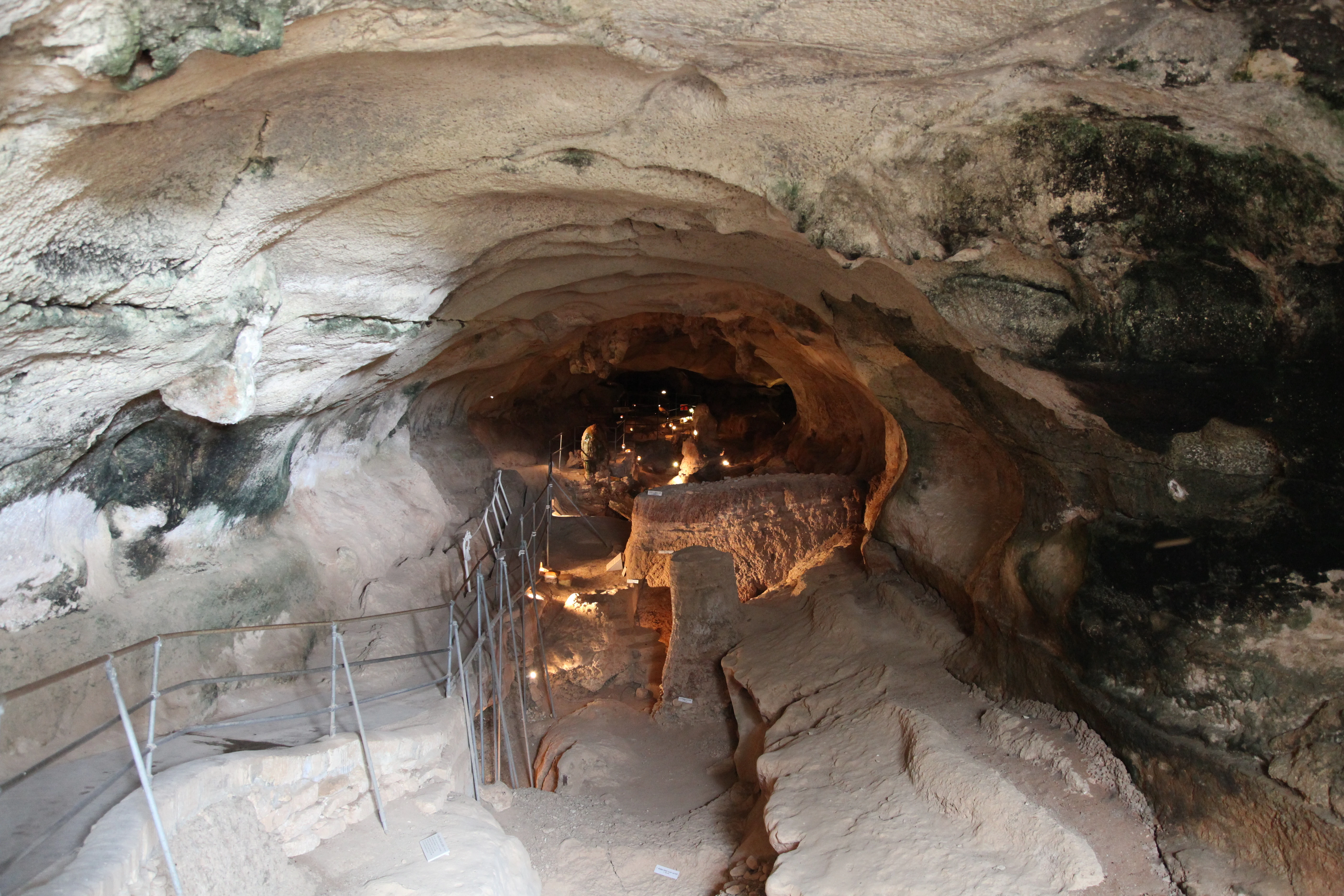
A wide angle view looking into a limestone cave with a lit walking path, metal railings, and natural rock walls.
The interior passage of the Għar Dalam cave, featuring limestone formations and an established walking path for visitors.

Ghar Dalam history and protected-area timeline

The cave first drew scientific attention in 1865, when Italian paleontologist Arturo Issel investigated its Neolithic remains. A more extensive excavation followed in 1892, led by John H. Cooke, whose collections were partly housed in Malta and partly sent to the British Museum. The Maltese material was later studied by Forsyth Major in 1902, who used the bones to identify a new dwarf hippopotamus species, Hippopotamus melitensis, marking a foundational moment in Maltese paleontology.

By 1925, the cave had been placed on Malta's Antiquities List, marking formal recognition of its heritage value. It was not opened to the public until March 1933, when a museum was established on site by the then Curator of Natural History, Joseph Baldacchino. Within a year of becoming curator in 1935, Baldacchino published a booklet summarizing the main excavations and research at Ghar Dalam, and the museum gradually evolved through updated specimens and labeling systems into a more modern interpretive space.

During World War II, the cave was repurposed as an air-raid shelter, embedding the site in the broader wartime history of the island. In 1980, some of the most irreplaceable artifacts in the museum, including four dwarf elephant tusks and the skull of a Neolithic child, were stolen, an event that underscored the fragility of the site's collection. In 2019, a project was announced to strengthen physical and interpretive links between Ghar Dalam and nearby heritage sites such as Ta Kaccatura and Borg in-Nadur, reflecting a growing interest in integrating the cave into wider regional heritage networks.

Ghar Dalam landscape and geographic character

Ghar Dalam sits in the low-lying southeastern corner of Malta, just outside Birzebbuga on the island's rural southern fringe. The surrounding terrain is characteristic of the southern Maltese landscape, with gently rolling agricultural land giving way to the limestone bedrock that defines much of the archipelago's geology.

The cave itself is a phreatic tube, a type of passage formed below the water table in soluble limestone, and it extends roughly 144 meters into the hillside. Only about the first 50 meters are accessible to visitors, but the entrance chamber functions as the natural threshold between the outdoor Mediterranean environment and the cool, sheltered interior. The site has no dramatic vertical relief or showy karst formations, but it has the muted, layered character typical of Maltese caves shaped by long periods of water movement and sediment accumulation.

Ghar Dalam ecosystems, habitats, and plant life

Although Ghar Dalam is not a wilderness park in the conventional sense, its ecological importance is rooted in what its deposits reveal about the natural history of the Maltese islands rather than in living ecosystems above ground. The cave has preserved a layered record of past environments stretching from the Early or Middle Pleistocene through to the recent Holocene, making it a natural archive of Maltese biodiversity across deep time.

The stratigraphy of the cave, divided into numbered layers from sterile clays at the base through bone-rich breccias, red earth horizons, and finally dark Holocene soils, reflects shifting climate, vegetation, and animal communities over hundreds of thousands of years. The lower layers preserve evidence of a richer Pleistocene fauna, while upper layers document the transition to a Holocene landscape shaped increasingly by human activity and introduced domestic species.

Above ground, the cave sits within the typical southeastern Maltese rural mosaic of fields, scrubby limestone garrigue, and small agricultural plots. The real ecological significance of the site, however, lies in its preserved subterranean deposits, which act as a long-term biological time capsule for the central Mediterranean.

Ghar Dalam wildlife and species highlights

Ghar Dalam is internationally significant not for present-day living wildlife but for the extraordinary fossil fauna preserved in its stratified deposits. The deeper Pleistocene layers contain the remains of dwarf elephants, including Palaeoloxodon mnaidriensis, as well as two species of dwarf hippopotamus, Hippopotamus pentlandi and Hippopotamus melitensis, the latter first described on the basis of these very finds.

Larger Pleistocene predators such as the brown bear and the wolf are also represented in the lower red earth layer, alongside red fox, voles including the endemic Pitymys melitensis, shrews, bats, turtles, and toads. The cave also preserves remains of the giant swan Cygnus falconeri, a remarkable example of island gigantism, as well as several endemic Maltese deer species, some of which survived into the Chalcolithic before going extinct around 4,000 years ago.

The upper Holocene layers document a very different fauna, dominated by domestic animals such as cattle, sheep, goats, pigs, and cats, alongside introduced species such as the black rat, house mouse, and rabbit. Together, these layers tell a vivid story of how Malta's wildlife shifted from a community of strange island-adapted giants and dwarfs to one characterized by human-introduced species, with Ghar Dalam serving as the principal fossil record of that transition.

Ghar Dalam conservation status and protection priorities

Conservation at Ghar Dalam refers both to the preservation of the site and its collections, and to the significance of the cave as a record of biodiversity loss in the Maltese islands. The site has been formally protected since 1925 through its inclusion on the Antiquities List, and it is currently managed by Heritage Malta as both a museum and a visitor cave, giving it a long institutional history of heritage protection.

The cave's deposits are themselves a form of conservation archive, preserving evidence of species that have entirely disappeared from Malta, including dwarf elephants, dwarf hippopotamuses, the giant swan, and endemic deer. By maintaining the museum collection and protecting the cave environment, Heritage Malta safeguards material that documents how island ecosystems change, shrink, and vanish under shifting climates and human pressure.

The 1980 theft of irreplaceable specimens, including dwarf elephant tusks and a Neolithic child's skull, served as a sharp reminder of the vulnerability of such collections. Subsequent upgrades to the museum's displays, labeling, and security reflect a continuing effort to balance public access with the protection of one of the most sensitive paleontological and archaeological resources in the central Mediterranean.

Ghar Dalam cultural meaning and human context

Ghar Dalam occupies a central place in Maltese cultural identity as one of the country's foundational heritage sites. Its role in anchoring the earliest Neolithic phase of Maltese prehistory has made it a touchstone for national narratives about deep antiquity and the long human presence on the islands.

For more than a century, the cave has also been a key site of scientific collaboration and interpretation, from the Italian, British, and Maltese-led excavations of the nineteenth and early twentieth centuries to the modern museums displays curated by Heritage Malta. Its wartime use as an air-raid shelter during World War II adds another layer to its cultural memory, linking prehistoric and recent histories in a single physical place.

The site's name itself, meaning 'Cave of Dalam' rather than 'Cave of Darkness' as is sometimes assumed, reflects the way local Maltese history and family identities are embedded even in the most ancient-looking landscapes of the islands.

Top sights and standout views in Ghar Dalam

Ghar Dalam's standout quality is the unusual combination of a short visitor cave with an exceptionally rich on-site museum, all built around a single stratified paleontological and archaeological sequence. Within a few dozen meters of cave passage, visitors can see the entrance to one of the Mediterranean's most important Pleistocene fossil deposits.

The cave also stands out as the namesake of the Ghar Dalam phase of the early Maltese Neolithic and, until 2025, held the record for the earliest known evidence of human settlement on Malta. These overlapping scientific and cultural roles make the site both a paleontological landmark and an archaeological cornerstone, with the museum serving as a compact but information-dense interpretive window into both.

Best time to visit Ghar Dalam

Ghar Dalam is an indoor cave and museum experience, so it can be visited comfortably throughout much of the year regardless of outdoor conditions. The cave interior maintains a relatively stable, cool environment, which is welcome during the hot Maltese summer months, while the surrounding rural approach is easiest to enjoy in the milder seasons of spring and autumn.

Seasonality matters less for the cave itself than for the broader Birzebbuga and southern Malta experience, where cooler months tend to be more pleasant for walking between the cave and nearby coastal or heritage sites. Visitors interested in pairing the visit with outdoor exploration of the surrounding area may find spring and early autumn particularly rewarding.
Monthly climate preview

Examine long-term representative measurements and monthly climate patterns across Malta

Għar Dalam Climate Normals, Annual Temperature and Precipitation Rhythm

Long-term NASA Power climatology records outline measured average temperature and precipitation rhythms across Għar Dalam in Malta. Detailed month-by-month datasets provide broader context for analyzing regional climate shifts and multi-year environmental baselines.
Annual mean20 °C
14 °C27 °C
Jan15°
Feb14°
Mar15°
Apr16°
May19°
Jun22°
Jul25°
Aug27°
Sep25°
Oct23°
Nov19°
Dec16°
Warmest month
August

26.6 °C

Coolest month
February

13.9 °C

Wettest month
November

3 mm/day

Driest month
July

0.1 mm/day

Park location guide

Geography guide, regional context, and park location map for Ghar Dalam

Ghar Dalam park geography, regions, and map view in Malta

Understand where Ghar Dalam sits in Malta through a broader geographic reading of the surrounding landscape, nearby location context, and its mapped position within the national park landscape.

How Ghar Dalam fits into Malta

Malta is a small island nation in the Mediterranean, located between Italy, Tunisia, and Libya. With a population of about 520,000 spread over 316 km², it is one of the world's most densely populated countries. The country has a long history of foreign rule and is known for its strategic position, historic sites, and membership in the EU, Commonwealth, and UN.

Wider geography shaping Ghar Dalam in Malta

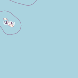
Malta is located in the Mediterranean Sea between Sicily and North Africa, approximately 80 km south of Italy, 284 km east of Tunisia, and 333 km north of Libya. The archipelago sits at coordinates 35°54′N 14°31′E.

Map view of Ghar Dalam

Use this park location map to pinpoint Ghar Dalam in Malta, understand its exact geographic position, and read its mapped placement within the surrounding landscape more clearly.

Pigeon | © OpenStreetMap contributors

Examine mapped terrain, geological layers, and the protected landscape environment.

Għar Dalam Photos and Visual Exploration of Limestone Cave Scenery

Visual documentation reveals the limestone cave structure, surrounding rural terrain, and sedimentary deposits that define the protected landscape. Photographic records provide clear visual context for the geological formations and fossil environments preserved within the regional ecosystem.

A wide angle view looking into a limestone cave with a lit walking path, metal railings, and natural rock walls.

A skeletal display of a prehistoric dwarf elephant inside a glass case at the Għar Dalam site museum, with checkered floors and museum cabinetry in the background.

Park atlas

Compare surrounding regional geography and connected protected landscapes

Explore Protected Areas and Parks Near Għar Dalam in Malta

Browse other protected areas and regional parks located across the surrounding Maltese landscape after examining Għar Dalam. Continuing outward into adjacent natural terrain provides a broader geographic comparison of local limestone topography and island conservation sites.
A watercolor painting showing a soft landscape with green rolling hills, low vegetation, and a calm water surface against a pastel sky.
Nature reserveSouth Eastern Region
About 1.9 km away#1 closest

East

Il-Ballut ta' Marsaxlokk Nature Reserve: Geography and Protected Wetland Landscapes

Essential salt marsh habitat in Malta's South Eastern Region

Il-Ballut ta' Marsaxlokk serves as a critical protected area, preserving a rare salt marsh landscape within the coastal environment of Malta. This reserve features a compact mosaic of muddy canals, halophytic vegetation, and Mediterranean coastal terrain. Its inclusion in the Natura 2000 network highlights its regional importance as a refuge for migratory birds and a focal point for environmental conservation in the South Eastern Region.

Area
0.23 km²
Established
2018
IUCN
IV
Relief
Lowland
Nature reserveMarsaxlokk
About 3.8 km away#2 closest

East

Xrobb l-Għaġin Nature Park: Protected Coastal Landscape in Marsaxlokk, Malta

A compact peninsula of protected cliffs and historic archaeological sites

Xrobb l-Għaġin Nature Park spans a low-lying coastal peninsula near Marsaxlokk, combining rocky Mediterranean shoreline with significant prehistoric temple remains. This protected area serves as a focal point for environmental education and coastal terrain analysis, showcasing the integration of natural heritage and historical coastal defense within a compact geographic boundary.

Area
0.155 km²
Relief
Lowland
Scope
Terrestrial
Water
Minor water
National parkMalta
About 11 km away#3 closest

Northwest

Ta' Qali National Park: Malta's Largest Urban Protected Landscape and Recreation Hub

Mapped Gardens, Event Venues, and Recreational Zones

Ta' Qali National Park serves as a vital green lung in central Malta, showcasing a landscape transformed from a wartime airfield into a modern urban protected area. This national park is recognized for its extensive recreational zones, meticulously designed formal gardens, and a prominent open-air concert venue that hosts major cultural events. Its relatively flat terrain and planned infrastructure offer a distinct map-based perspective on urban parkland, highlighting its significance as a major public amenity and a key feature of Malta's landscape.

Area
0.35 km²
IUCN
V
Relief
Lowland
Climate
Mediterranean
A pale, minimalist watercolor illustration showing soft, rolling green and yellow hills against a white background.
Nature reserveMalta
About 12 km away#4 closest

Southwest

Filfla Nature Reserve: The Protected Limestone Plateau and Geography of Malta

Tracing the limestone cliffs and seabird sanctuary of the Maltese archipelago

Filfla is a small, uninhabited limestone islet lying 4.5 kilometres south of the main island of Malta. Defined by its 60-metre sea cliffs and flat plateau, this protected nature reserve functions as a crucial Important Bird Area and a landmark for regional Mediterranean biodiversity. Examine the mapped boundaries and geological profile of this site to understand its status as the southernmost extremity of the Maltese archipelago.

Area
0.06 km²
Established
1980
Relief
Upland
Climate
Mediterranean
A soft, pastel-toned watercolor painting of a rolling green landscape with a small body of water in the foreground and a silhouette of a building on a hill in the distance.
Wildlife reserveMalta
About 12 km away#5 closest

West

Buskett Gardens Wildlife Reserve: Geography and Protected Landscape Map of Malta

A rare sheltered woodland valley in the central Mediterranean

Buskett Gardens serves as a critical protected woodland in the heart of the Maltese islands. Nestled in the fertile Wied il-Luq valley, the site offers an unusually green, shaded environment of broadleaved trees and conifers. This reserve functions as an Important Bird Area and a historic cultural landscape, providing a lush contrast to the exposed limestone plateau of rural Malta.

Area
0.47 km²
Relief
Upland
Scope
Terrestrial
Water
Minor water
A pale, minimalist watercolor painting depicting St Paul's Island in Malta, showing green rolling landforms and a hint of a structure against a light background.
Protected areaMalta
About 18 km away#6 closest

Northwest

St Paul's Island Protected Landscape and Maltese Coastal Geography Overview

Uninhabited Mediterranean island and heritage landmark

St Paul's Island represents a unique Mediterranean limestone islet featuring maritime garigue habitat and historic ruins. Located near the Mellieħa coastline, this protected area provides a compact example of Maltese coastal geography, defined by exposed cliffs and an enduring connection to local maritime history.

Area
0.101 km²
Relief
Lowland
Scope
Mixed
Water
Water-dominated
A horizontal watercolor painting depicting a soft-toned, abstract coastal landscape with gentle green hills, grassy foreground patches, and a calm, pale pool of water against a white background.
Marine protected areaMalta
About 20 km away#7 closest

Northwest

Ras ir-Raħeb Marine Protected Area: Geographic Profile and Mapped Coastal Landscape

Coastal cliffs and protected marine zones in north western Malta.

Ras ir-Raħeb serves as a pivotal marine protected area along the Malta coastline, where high limestone cliffs meet complex underwater habitats. This site links historical archaeological remnants with modern ecological conservation, offering a unique geographic snapshot of the Rabat plateau edge. Its mapped boundaries encompass both the terrestrial promontory and the essential seagrass meadows beneath the surface, providing a critical reference point for Mediterranean coastal geography and protected land status.

Established
2005
Relief
Upland
Climate
Mediterranean
Access
Moderate access
A horizontal watercolor painting showing soft green hills, grassy marshland, and a calm water channel under a light, hazy sky.
Nature reserveGozo
About 26 km away#8 closest

Northwest

Comino Nature Reserve: Geography, Protected Marine Areas, and Karst Terrain in Gozo

Island ecology and coastal landscape mapping

Examine the protected geography of Comino, an island nature reserve near Gozo defined by limestone plateaus and sheltered bays. This overview covers the ecological boundaries of the Natura 2000 marine area, the distribution of coastal sea caves, and the topographic patterns of this Important Bird Area.

Area
3.5 km²
Relief
Lowland
Climate
Mediterranean
Access
Moderate access

Common questions about visiting, size, designation, and location context for Ghar Dalam

Ghar Dalam FAQs for park facts, access, geography, and protected area context

Find quick answers about Ghar Dalam, including protected-area facts, park geography, trail and visitor context, and how the park fits into its surrounding country and regional landscape.
MoriAtlas Explorer

Continue Your Protected Areas Search Across the Global Atlas

Deepen your exploration by continuing the structured search for national parks and protected areas worldwide. Utilize the comprehensive filtering capabilities to compare different conservation landscapes and refine your understanding of global park geography. Discover more about the distribution and characteristics of protected natural areas.

Global natural geography