Mori Atlas logo
Nature reserveGoose Island Conservation Park

Understanding the mapped boundaries and island geography of this vital marine mammal and seabird refuge

Goose Island Conservation Park: A Protected Marine Island Reserve in the South Australia Spencer Gulf

Goose Island Conservation Park functions as a critical offshore refuge within the Spencer Gulf, protecting a cluster of small islands and rocky outcrops near Port Victoria. This nature reserve provides essential, predator-free terrain for breeding black-faced cormorant colonies and Australian sea lion populations. As a formally recognized Important Bird Area, the site represents an ecologically significant node within the South Australian protected area network, offering undisturbed habitat amidst the wider marine environment.

island reserveoffshore islandsSpencer Gulfseabird breeding colonyImportant Bird Areamarine mammal refuge

Goose Island Conservation Park

Nature reserve

Park overview

Structured park overview, official facts, and landscape profile for Goose Island Conservation Park

Goose Island Conservation Park park facts, protected area profile, and essential visitor context

Review the core facts for Goose Island Conservation Park, including designation, size, terrain, visitor scale, habitats, and operating context in one park-focused overview.

About Goose Island Conservation Park

Goose Island Conservation Park sits in the sheltered waters of Spencer Gulf in South Australia, where the southern coastline of the Yorke Peninsula meets an array of small, low-lying islands. The park is anchored by Goose Island, with additional islets and rocks distributed around the much larger Wardang Island, which lies just to the south. Though the reserve covers only a small area, its offshore setting gives it an identity shaped by sea, weather, and breeding wildlife rather than terrestrial forests or mountains.

The protected area has a long administrative history. In 1966, the islands that would later form the core of the park were declared fauna reserves under the Fauna Conservation Act 1965, reflecting an early recognition that these offshore rocks had special value for native wildlife. Six years later, in 1972, the land was re-proclaimed as a conservation park with the explicit goal of conserving an offshore breeding and refuge area for seabirds and the Australian sea lion, Neophoca cinerea. This statutory foundation has shaped the park's enduring role as a marine wildlife sanctuary.

Today the park is recognized through international conservation classifications as well. It is listed as an IUCN Category III protected area, a designation reserved for natural monuments or features with notable ecological value. BirdLife International has further identified the park as an Important Bird Area, primarily because it supports a globally significant share of the world's black-faced cormorant breeding population. The combination of formal protection, international recognition, and offshore island character makes Goose Island Conservation Park a distinctive, small-scale but highly targeted conservation reserve in the South Australian protected-area network.

Quick facts and research context for Goose Island Conservation Park

Goose Island Conservation Park is located in Spencer Gulf, South Australia, several kilometers offshore from Port Victoria. The park protects a group of small islands and rocks around Wardang Island, including Goose Island, Little Goose Island, Seal Rocks, White Rocks, Beatrice Rock, Island Point, Rocky Island, Boat Rock, and Bikini Islets. It was proclaimed as a conservation park in 1972, six years after the underlying islands were first declared as fauna reserves in 1966. The reserve is classified as an IUCN Category III protected area (natural monument or feature) and was placed on the (now-defunct) Register of the National Estate in 1980.

Protection and recognition

Documented protection scope and official designation records for regional conservation

Goose Island Conservation Park Protection Status and International Recognition

Analysis of Goose Island Conservation Park reveals documented protection status and mixed management scope within the regional protected area network. Official records compile available designation data and international recognition metrics for conservation mapping.

Protection details

Protection scope
Mixed
Transboundary protection
No
Park context

Deeper park guide and search-rich context for Goose Island Conservation Park

Goose Island Conservation Park history, landscape, wildlife, and travel context

Explore Goose Island Conservation Park through its history, landscape character, ecosystems, wildlife, conservation priorities, cultural context, and seasonal travel timing in a structured park guide built for atlas discovery and search intent.

Why Goose Island Conservation Park stands out

Goose Island Conservation Park is best known for its offshore seabird breeding colonies, particularly its large population of black-faced cormorants, which makes the area internationally recognized as an Important Bird Area by BirdLife International. The park is also recognized for protecting refuge habitat for the Australian sea lion, an endemic marine mammal that relies on quiet, predator-free islets for breeding and resting. Together, these seabird and marine mammal roles give the small island reserve an ecological significance that far exceeds its modest size.

Goose Island Conservation Park history and protected-area timeline

The history of Goose Island Conservation Park begins in 1966, when the South Australian government declared Goose Island, White Rock Island, and the adjacent rocky islands to the northwest as fauna reserves under the Fauna Conservation Act 1965. This early designation marked the islands as important wildlife habitat deserving formal protection, and it laid the groundwork for later, stronger conservation measures.

In 1972, the fauna reserves were upgraded and reorganized as a dedicated conservation park. The new proclamation explicitly identified the park's purpose as the conservation of an offshore breeding and refuge area for seabirds and the Australian sea lion. By creating a single, named protected area that grouped together Goose Island, the surrounding islets, and several rocks around Wardang Island, the government formalized the islands' role as a long-term wildlife refuge.

The park received further recognition in 1980, when it was included on the Register of the National Estate, a federal inventory of culturally and environmentally significant places that has since been discontinued. The park continues to be managed by the South Australian Department for Environment and Water, and its century-spanning history reflects a gradual but consistent strengthening of protection for a small but ecologically important group of islands.

Goose Island Conservation Park landscape and geographic character

The landscape of Goose Island Conservation Park is defined by its marine and island character rather than any dramatic terrestrial relief. The park consists of a scatter of small islands and rocky outcrops arranged around Wardang Island in the Spencer Gulf, an extensive, sheltered embayment on South Australia's coast. Goose Island itself is the namesake and central feature of the reserve, with Little Goose Island nearby and a series of named rocks and islets.

To the north of Wardang Island lie Goose Island, Little Goose Island, Seal Rocks, and White Rocks. To the east of Wardang Island are Beatrice Rock, Island Point, and Rocky Island. To the west sit Boat Rock and Bikini Islets. Together these islands and rocks form a loose ring of low-lying land surrounded by gulf waters, generally located between roughly five and twelve kilometers west to northwest of Port Victoria on the mainland. The terrain is exposed, wind-swept, and shaped by marine weathering, with the islands offering small pockets of coastal vegetation, rocky shores, and breeding sites above the tideline rather than forests, mountains, or inland water features.

Goose Island Conservation Park ecosystems, habitats, and plant life

The ecological character of Goose Island Conservation Park is shaped by its position as a group of low-lying offshore islands in a temperate gulf. Because the islands are isolated from the mainland and largely free of human settlement, they offer coastal habitats that have been allowed to function with minimal disturbance. These include rocky shorelines, low coastal scrub, and bare ground favored by nesting seabirds, as well as quiet beaches and rocks used by marine mammals as haul-out sites.

The park's ecological importance is closely tied to the role offshore islands play in the Gulf's broader seascape. Islands like those in this reserve provide nesting space safe from many terrestrial predators, rest areas for seabirds and seals traveling through the gulf, and stepping stones of habitat across an otherwise open water environment. This combination of isolation, coastal habitat, and ecological function gives the small park an outsized role in supporting marine and coastal biodiversity in Spencer Gulf.

Goose Island Conservation Park wildlife and species highlights

The wildlife of Goose Island Conservation Park is dominated by two main ecological themes: seabird breeding colonies and marine mammal use. The islands are recognized internationally for their importance to black-faced cormorants, with the park estimated to support up to 750 breeding pairs, a population significant enough to place it on BirdLife International's list of Important Bird Areas. Fairy terns have also been recorded breeding at the site, adding to the reserve's seabird character.

Beyond its birdlife, the park plays an important role for the Australian sea lion, Neophoca cinerea, a species endemic to southern Australian waters. Sea lions rely on quiet, undisturbed islands for breeding colonies and resting haul-outs, and the protected islands within the conservation park were specifically set aside to safeguard this function. Together, the seabird colonies and sea lion populations make the park one of the most wildlife-focused small island reserves in South Australia.

Goose Island Conservation Park conservation status and protection priorities

Goose Island Conservation Park has conservation significance that exceeds its small physical footprint. Originally protected as fauna reserves in 1966 and re-proclaimed as a conservation park in 1972, the islands have been the subject of formal protection for decades under South Australian law. The park's establishment purpose, the conservation of an offshore breeding and refuge area for seabirds and the Australian sea lion, reflects a deliberate conservation strategy aimed at maintaining critical marine wildlife habitats rather than simply preserving land.

The reserve has received strong external recognition. It is classified as an IUCN Category III protected area (natural monument or feature), placing it within an international framework used to track conservation values worldwide. BirdLife International has separately identified the park as an Important Bird Area because of its globally significant black-faced cormorant population, highlighting the reserve's relevance to international seabird conservation. A 1980 listing on the (now-defunct) Register of the National Estate added another layer of formal acknowledgment of the islands' environmental values. Today, the park continues to be managed by the South Australian Department for Environment and Water, with low visitor numbers helping to minimize disturbance to sensitive seabird and sea lion populations.

Top sights and standout views in Goose Island Conservation Park

Goose Island Conservation Park's standout features are its seabird breeding colonies and its role as a refuge for the Australian sea lion. The reserve supports an internationally significant population of breeding black-faced cormorants and also hosts breeding fairy terns, giving it formal recognition as a BirdLife International Important Bird Area. Its scattered group of small islands and rocks around Wardang Island, set several kilometers offshore in Spencer Gulf, creates the quiet, predator-isolated conditions that seabirds and sea lions depend on. Despite its modest size, the park's combination of statutory protection, international recognition, and focused ecological purpose makes it a small but high-value node in South Australia's protected-area network.

Best time to visit Goose Island Conservation Park

Because Goose Island Conservation Park is a remote offshore island reserve with only a few hundred visitors per year, access is generally most suitable during settled, calmer weather windows typical of the warmer months in southern Australia. Spring and early summer tend to offer milder sea conditions, longer daylight hours for boat travel, and active seabird breeding seasons on the islands. Winter can bring stronger winds and rougher gulf conditions, which can make landings on small, exposed islands more difficult. Visitors should view any trip as weather- and seasonal-dependent, with conditions varying year to year.
Monthly climate preview

Long term temperature averages and monthly precipitation distributions for South Australia

Goose Island Conservation Park Climate Normals and Annual Weather Patterns

Historical measurements from 1991 to 2020 outline the representative point climate rhythm for Goose Island Conservation Park, tracking average monthly temperatures alongside daily precipitation rates. Examining the full twelve month profile reveals detailed seasonal variations in temperature extremes and precipitation patterns across the protected terrain.
Annual mean17 °C
12 °C22 °C
Jan22°
Feb22°
Mar21°
Apr18°
May15°
Jun13°
Jul12°
Aug12°
Sep14°
Oct16°
Nov18°
Dec20°
Warmest month
February

22.3 °C

Coolest month
July

12 °C

Wettest month
June

1.8 mm/day

Driest month
January

0.5 mm/day

Park location guide

Geography guide, regional context, and park location map for Goose Island Conservation Park

Goose Island Conservation Park park geography, regions, and map view in Australia

Understand where Goose Island Conservation Park sits in Australia through a broader geographic reading of the surrounding landscape, nearby location context, and its mapped position within the national park landscape.

How Goose Island Conservation Park fits into Australia

Australia is a constitutional monarchy and federal parliamentary democracy comprising six states and ten territories. With a population of nearly 28 million, it is one of the world's most urbanised countries, with most people concentrated on the eastern seaboard. The country has a high Human Development Index and is known for its cultural diversity, ancient Aboriginal heritage, and unique wildlife.

Wider geography shaping Goose Island Conservation Park in Australia

Australia occupies the entire Australian continent, the island of Tasmania, and numerous smaller islands. It is the world's flattest and driest inhabited continent, featuring vast deserts in the interior (the Outback), tropical rainforests along the eastern coast, and a coastline bordering the Indian and Pacific Oceans.

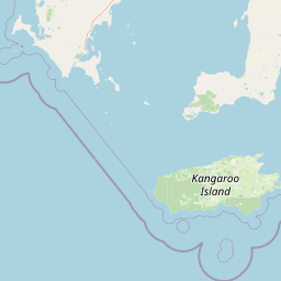
Map view of Goose Island Conservation Park

Use this park location map to pinpoint Goose Island Conservation Park in Australia, understand its exact geographic position, and read its mapped placement within the surrounding landscape more clearly.

Pigeon | © OpenStreetMap contributors

Location context for Goose Island Conservation Park

South Australia
Park atlas

Compare surrounding marine reserves and coastal protected landscapes across the region

Explore Protected Areas and Parks Near Goose Island Conservation Park

Continue browsing other parks near Goose Island Conservation Park to examine related marine reserves and coastal protected landscapes. Expanding the regional view helps place local island refuges into a wider geographic context of protected natural areas.
Wildlife reserveSouth Australia
About 51 km away#1 closest

North

Bird Islands Conservation Park: A Protected Coastal Landscape in South Australia

Key wildlife reserve on the Spencer Gulf coastline

Bird Islands Conservation Park represents a vital coastal habitat within South Australia. Covering islands and mainland sections near Wallaroo, the area integrates sand dunes, intertidal flats, and mangrove woodlands. This conservation site provides essential refuge for migratory shorebirds while maintaining a complex link between marine and terrestrial ecosystems on the Yorke Peninsula.

Area
3.69 km²
Established
1968
IUCN
VI
Relief
Lowland
Protected areaSouth Australia
About 66 km away#2 closest

Southwest

Carribie Conservation Park: Mapped Geography and Protected Area Overview in South Australia

Ecological terrain and native vegetation remnants on the Yorke Peninsula

Carribie Conservation Park is a 19-hectare protected area situated on the southern Yorke Peninsula of South Australia. The terrain consists of an undulating sandy plain characterized by two contrasting vegetation zones: a northern mallee scrub and a southern sheoak and tea-tree woodland. As a formal conservation site, it provides a vital window into the original botanical character of the region.

Area
0.19 km²
Established
1968
IUCN
III
Relief
Lowland
A wide watercolor illustration showing a coastal scene with green trees, a pinkish shoreline, and pale blue water against a white background.
State or regional parkSouth Australia
About 77 km away#3 closest

Northeast

Clinton Conservation Park: A Protected Coastal Wetland Reserve in South Australia

Mapping mangrove forests, tidal flats, and estuarine habitats.

Clinton Conservation Park protects a significant coastal corridor at the head of Gulf St Vincent, where mangroves, samphire flats, and low backing dunes create a rare, continuous sequence of undisturbed wetland environments. This park serves as a key nursery for regional aquatic species and a habitat node for migratory bird populations in South Australia.

Area
19.15 km²
Established
1970
IUCN
III
Relief
Lowland
A horizontal watercolor illustration of a coastal landscape with pale pink water, green marshy shorelines, and distant soft blue hills against a white background.
Nature reserveSouth Australia
About 86 km away#4 closest

Northwest

Franklin Harbor Conservation Park: Coastal Nature Reserve and Eyre Peninsula Protected Geography

Coastal conservation park and island habitat system in South Australia

This nature reserve protects rare mangrove and samphire flat associations along the eastern coast of the Eyre Peninsula. The geography encompasses a sheltered peninsula and four islands within the harbor, forming an essential maritime habitat for seabirds and reptiles in the South Australian coastal landscape.

Area
13.56 km²
Established
1976
IUCN
Ia
Relief
Lowland
National parkAustralia
About 96 km away#5 closest

Southwest

Dhilba Guuranda-Innes National Park: A Detailed Look at Its Australian Protected Landscape

Explore the park's mapped geography and natural terrain.

This section offers a focused atlas exploration of Dhilba Guuranda-Innes National Park, detailing its significance as a protected natural area within Australia. Gain understanding of its unique geographic characteristics, mapped boundaries, and its contribution to the country's diverse natural landscapes. This provides detailed context for anyone interested in Australia's protected land inventory and regional geography.

Area
94.15 km²
Established
1970
Visitors
200K annual
Relief
Mixed relief
National parkAustralia
About 96 km away#6 closest

Southwest

Innes National Park National Park: Mapped Protected Landscape and Regional Geography

Explore its geographic setting and natural terrain.

Delve into the protected landscape and geographic particulars of Innes National Park. This entry provides detailed insights into its mapped boundaries and the surrounding natural terrain within Australia. Understanding Innes National Park's place in the broader geographic atlas helps users compare and contrast protected areas across different regions and nations.

IUCN
II
National parkAustralia
About 96 km away#7 closest

East

Adelaide International Bird Sanctuary National Park, Winaityinaityi Pangkara National Park: Protected Landscape and Geographic Context

Explore the mapped natural terrain of this Australian protected area.

This national park page offers detailed insights into Adelaide International Bird Sanctuary National Park, Winaityinaityi Pangkara, focusing on its protected status and geographic attributes. Understand the park's placement within Australia, its mapped boundaries, and the natural landscape features that define it. It serves as a vital entry point for atlas-driven discovery of protected areas, emphasizing the geographical context of this significant national park.

Access
Access unknown
Season
Seasonal
Natural monumentSouth Australia
About 125 km away#8 closest

Northeast

Clements Gap Conservation Park: A South Australian Natural Monument and Cultural Landscape

Mapping bushland corridors and historic heritage in the Mid North region.

Clements Gap Conservation Park occupies a 7.9 square kilometre footprint, offering a glimpse into the natural terrain of the Mid North region. The area functions as a protected monument that preserves native bushland alongside the built traces of a historic township, showcasing the layered human and environmental geography characteristic of the Spencer Gulf hinterland.

Area
7.9 km²
Established
1963
IUCN
III
Relief
Upland

Common questions about visiting, size, designation, and location context for Goose Island Conservation Park

Goose Island Conservation Park FAQs for park facts, access, geography, and protected area context

Find quick answers about Goose Island Conservation Park, including protected-area facts, park geography, trail and visitor context, and how the park fits into its surrounding country and regional landscape.
MoriAtlas Explorer

Continue Your Protected Areas Search Across the Global Atlas

Deepen your exploration by continuing the structured search for national parks and protected areas worldwide. Utilize the comprehensive filtering capabilities to compare different conservation landscapes and refine your understanding of global park geography. Discover more about the distribution and characteristics of protected natural areas.

Global natural geography