

Mori Atlas logo
Nature reserveGreenly Island Conservation Park

Examining the geographic boundaries and marine-influenced terrain of this protected island.

Greenly Island Conservation Park and Protected Nature Reserve in South Australia

Greenly Island Conservation Park encompasses a remote, rocky island environment situated in the Southern Ocean off the western coast of the Eyre Peninsula. This nature reserve serves as an essential, strictly protected habitat for Australian sea-lion and New Zealand fur-seal colonies, reflecting over a century of conservation priority for this exposed island terrain. By maintaining its status as a Category Ia nature reserve, the area safeguards the delicate intersection of isolated island ecosystems and cold-water marine processes.

island reservemarine mammalsAustralian sea-lionNew Zealand fur-sealhaul-out siteEyre Peninsula

Greenly Island Conservation Park

Nature reserve

Park overview

Structured park overview, official facts, and landscape profile for Greenly Island Conservation Park

Greenly Island Conservation Park park facts, protected area profile, and essential visitor context

Review the core facts for Greenly Island Conservation Park, including designation, size, terrain, visitor scale, habitats, and operating context in one park-focused overview.

About Greenly Island Conservation Park

Greenly Island Conservation Park is a South Australian protected area defined almost entirely by its offshore island setting and its role as a refuge for marine wildlife. The park protects Greenly Island, a single island lying along the western approaches to the Eyre Peninsula, where the South Australian coastline meets the often turbulent waters of the Southern Ocean. Its location roughly 70 kilometres west of Coffin Bay places it in a remote seascape characterised by strong swells, cool waters, sparse vegetation, and limited human presence.

Although the island is small, its ecological footprint is disproportionately significant. The combination of rocky shoreline, isolation from mainland disturbance, and the availability of suitable haul-out substrates makes Greenly Island an important site for pinniped populations, particularly Australian sea-lions and New Zealand fur-seals. These animals use the island as a place to rest, breed, and rear young away from terrestrial predators and human activity, and the conservation park was explicitly created to recognise and defend this function.

The park’s formal designation reflects the priorities of South Australia’s protected-area framework. Declared under the National Parks and Wildlife Act 1972, it sits within a system of reserves designed to safeguard the state’s distinctive biodiversity, while its IUCN Category Ia classification frames it as a strict nature reserve. This category is reserved for areas managed primarily for ecosystem conservation and the maintenance of natural processes, implying a management philosophy that keeps human visitation, infrastructure, and landscape modification to a minimum.

For visitors, researchers, and conservation planners, the park represents a small but ecologically meaningful piece of South Australia’s marine and island conservation estate. Its significance lies less in its physical scale than in the integrity of the ecological processes it supports, and in the role it plays in protecting populations of marine mammals that depend on a network of undisturbed island sites along this stretch of coast.

Quick facts and research context for Greenly Island Conservation Park

Greenly Island Conservation Park covers a compact area focused on a single offshore island off South Australia’s Eyre Peninsula. The island lies well offshore in the Great Australian Bight approach, around 70 kilometres west of Coffin Bay, anchoring the park firmly in a marine-influenced, wave-exposed environment.

Its protected-area framework is unusually layered: an early 1919 declaration gave the island continuing legal protection, and a 1972 declaration under South Australia’s National Parks and Wildlife Act formally designated the conservation park to defend its fragile ecology and the marine mammal haul-outs around it. The park’s IUCN Category Ia (strict nature reserve) status places it among South Australia’s most strictly protective categories, signalling its role as a conservation-focused island reserve rather than a visitor-oriented park.

Protection and recognition

Documented protection scope and international recognition records for Greenly Island Conservation Park.

Greenly Island Conservation Park Protection Status and Designation History

Greenly Island Conservation Park holds a documented mixed protection status established in the year 1972. Structured conservation records provide historical designation details without imported international recognition sources.

Protection details

Protection scope
Mixed
Designated year
1972
Transboundary protection
No
Park context

Deeper park guide and search-rich context for Greenly Island Conservation Park

Greenly Island Conservation Park history, landscape, wildlife, and travel context

Explore Greenly Island Conservation Park through its history, landscape character, ecosystems, wildlife, conservation priorities, cultural context, and seasonal travel timing in a structured park guide built for atlas discovery and search intent.

Why Greenly Island Conservation Park stands out

Greenly Island Conservation Park is best known for protecting the haul-out areas of two marine mammal species along South Australia’s western coast: the Australian sea-lion and the New Zealand fur-seal. These colonies are a defining reason for its existence and underpin its strict nature reserve classification. The reserve is also recognised for its long history of layered protection, beginning with an early 20th-century declaration and later consolidated under formal conservation park status in 1972. Together, the marine mammal colonies and the park’s strict, low-disturbance protection regime form the core of its identity.
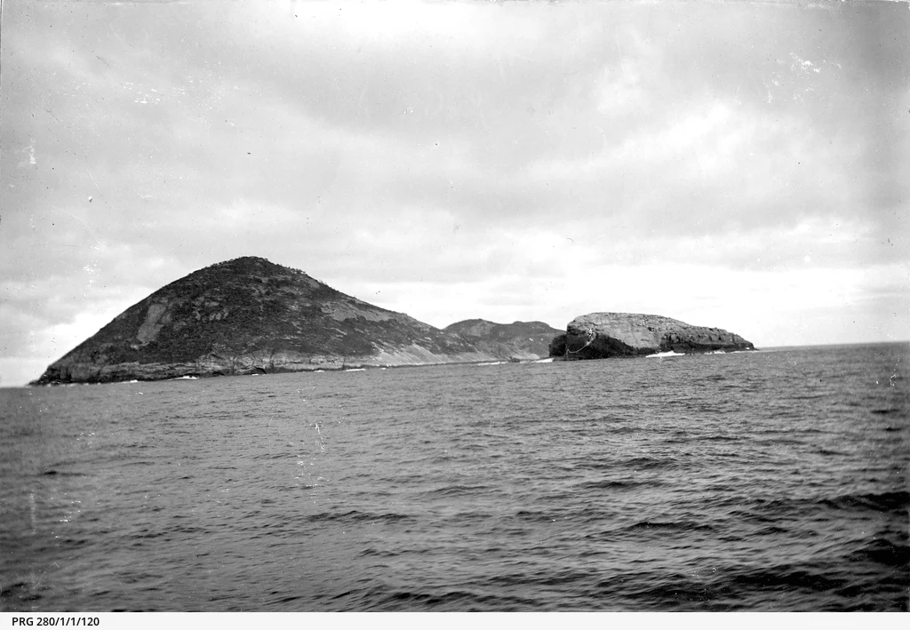
A black and white photograph showing a distant view of Greenly Island, a rugged island with a prominent peak surrounded by the open ocean under a cloudy sky.
A historical view of Greenly Island from the sea, circa 1903.

Greenly Island Conservation Park history and protected-area timeline

Greenly Island has a longer protection history than many of South Australia’s offshore reserves. The first formal declaration protecting the island dates to 1919, recognising the island’s values well before modern conservation legislation in the state was formalised. This early designation laid the groundwork for the island’s continued legal protection throughout the 20th century.

In 1972, the South Australian government consolidated and expanded protection through the National Parks and Wildlife Act 1972, formally designating the area as Greenly Island Conservation Park. The legislation explicitly framed the park’s purpose as protecting the island’s delicate ecology and the haul-out areas used by Australian sea-lions and New Zealand fur-seals, anchoring its status around both ecosystem and wildlife conservation.

The park’s current classification as an IUCN Category Ia protected area reflects modern international standards for strict nature reserves, applied to a site whose history of protection spans more than a century. Together, the 1919 declaration, the 1972 conservation park status, and the international IUCN framework represent a layered response to the ecological value of a small but strategically located island.

Greenly Island Conservation Park landscape and geographic character

Greenly Island itself defines the landscape of Greenly Island Conservation Park. The island sits in open ocean off the western Eyre Peninsula, exposed to prevailing swells and weather systems sweeping in from the Southern Ocean. This exposure shapes the park’s coastal character and contributes to the conditions that influence both terrestrial vegetation and marine species behaviour.

The terrain is consistent with a small offshore island in a cool, wave-swept environment: rocky shores, exposed bedrock, and limited soil cover. Vegetation on such islands in this part of South Australia typically reflects exposure, salt spray, and nutrient limitation, producing compact, hardy plant communities. There is little sheltered beachfront of scale, and the overall impression is of a low, wind-shaped landmass integrated tightly into its marine setting.

Because the park is defined by a single island and its surrounding marine influence, the landscape experience is one of isolation, oceanic exposure, and ecological simplicity. The juxtaposition of rocky island terrain against open ocean is the scenic anchor of the reserve, and it underpins both the park’s natural character and its conservation priorities.

Greenly Island Conservation Park ecosystems, habitats, and plant life

The nature of Greenly Island Conservation Park is shaped by the interaction between a small landmass and its surrounding marine environment. As an offshore island, its terrestrial ecosystems are inherently limited in extent and heavily influenced by salt spray, wind, and the relatively harsh conditions of southern Australian coastal waters.

Terrestrial habitats on the island reflect typical patterns for isolated, wave-exposed islands along South Australia’s western coast: low vegetation cover, stunted or wind-pruned plant communities, and a simple ecological structure dominated by the demands of survival in a salty, nutrient-poor setting. Seabirds and coastal species dependent on island refuges form part of this terrestrial picture, with the island’s isolation providing relative protection from mainland predators and human disturbance.

Marine influence is equally central. The waters around the island are part of the broader marine system that supports the haul-out populations the park was created to protect. Algal coverage, fish assemblages, and the broader productivity of surrounding waters influence both the mammals that depend on the island and the seabirds and smaller fauna that use the island seasonally. The interplay between a constrained terrestrial ecosystem and an adjacent productive marine environment gives the park its distinct ecological identity.

Greenly Island Conservation Park wildlife and species highlights

The wildlife significance of Greenly Island Conservation Park centres on its marine mammal populations. The park was explicitly established to protect haul-out areas used by Australian sea-lions and New Zealand fur-seals, two species whose breeding and resting behaviour depend on undisturbed island sites along the South Australian coast.

Australian sea-lions are a species of considerable conservation concern, with a restricted breeding range centred on southern Australian waters. Greenly Island forms part of the network of island sites that this species relies on for pup-rearing and colony maintenance. The island’s rocky shores and isolation from frequent human activity make it suitable habitat, while its protected status keeps that habitat intact.

New Zealand fur-seals, while more broadly distributed across southern Australia and New Zealand, also use the island as a haul-out site. Their presence adds to the marine mammal importance of the park and reinforces the rationale for the reserve’s strict protection status. Beyond the pinniped colonies, the island is likely to support seabird populations typical of exposed South Australian island environments, although the conservation focus of the park remains clearly on the marine mammals and the broader integrity of the island ecosystem.

Greenly Island Conservation Park conservation status and protection priorities

The conservation significance of Greenly Island Conservation Park lies in its role as an anchored, strictly protected refuge within South Australia’s broader marine mammal conservation network. By formally protecting Greenly Island and its surrounding haul-out areas, the park contributes directly to the resilience of Australian sea-lion and New Zealand fur-seal populations along the western Eyre Peninsula.

The reserve’s IUCN Category Ia classification signals a management approach aimed at ecosystem conservation and the maintenance of natural processes, with minimal interference from infrastructure, tourism development, or other human activity. This makes it functionally different from parks oriented primarily around visitor use. Its purpose is to maintain the natural conditions that allow sensitive species to continue using the island as breeding and resting habitat.

The park’s layered protection history, beginning in 1919 and consolidated through the 1972 declaration under the National Parks and Wildlife Act, also gives it conservation durability. Long-running legal protection helps shield the site from changes that might otherwise erode its ecological value, and reinforces its standing as a site where conservation outcomes, rather than visitor services, define management priorities.

Top sights and standout views in Greenly Island Conservation Park

Standout qualities of Greenly Island Conservation Park include its strict IUCN Category Ia management status, its location on a single exposed island in the Southern Ocean approach to the Eyre Peninsula, and its explicit role in protecting haul-out populations of Australian sea-lions and New Zealand fur-seals.

Equally notable is the park’s layered protection history spanning more than a century, from the 1919 declaration to the 1972 conservation park status. This long arc of legal protection gives the reserve a meaningful profile within South Australia’s conservation land system, even though the park itself occupies a compact physical footprint.

Best time to visit Greenly Island Conservation Park

As an IUCN Category Ia strict nature reserve with an explicit focus on ecosystem and marine mammal protection, Greenly Island Conservation Park is not primarily a visitor-access site, and detailed seasonal visitation guidance is not well supported by the source material. Any visit-oriented framing should respect the reserve’s strict nature reserve status and the sensitivity of its wildlife values.

Monthly climate preview

Long-term monthly temperature and precipitation averages for South Australia

Greenly Island Conservation Park Climate Normals and Annual Weather Patterns

Greenly Island Conservation Park records long-term baseline temperatures ranging from mild winter lows to warm summer maximums alongside measured monthly precipitation patterns. Reviewing the complete twelve-month climatology profile provides deeper data on multi-year meteorological averages across the protected area.
Annual mean16 °C
14 °C19 °C
Jan19°
Feb19°
Mar18°
Apr18°
May16°
Jun15°
Jul14°
Aug14°
Sep14°
Oct15°
Nov16°
Dec18°
Warmest month
February

19.2 °C

Coolest month
August

13.9 °C

Wettest month
June

2.1 mm/day

Driest month
January

0.5 mm/day

Park location guide

Geography guide, regional context, and park location map for Greenly Island Conservation Park

Greenly Island Conservation Park park geography, regions, and map view in Australia

Understand where Greenly Island Conservation Park sits in Australia through a broader geographic reading of the surrounding landscape, nearby location context, and its mapped position within the national park landscape.

How Greenly Island Conservation Park fits into Australia

Australia is a constitutional monarchy and federal parliamentary democracy comprising six states and ten territories. With a population of nearly 28 million, it is one of the world's most urbanised countries, with most people concentrated on the eastern seaboard. The country has a high Human Development Index and is known for its cultural diversity, ancient Aboriginal heritage, and unique wildlife.

Wider geography shaping Greenly Island Conservation Park in Australia

Australia occupies the entire Australian continent, the island of Tasmania, and numerous smaller islands. It is the world's flattest and driest inhabited continent, featuring vast deserts in the interior (the Outback), tropical rainforests along the eastern coast, and a coastline bordering the Indian and Pacific Oceans.

Map view of Greenly Island Conservation Park

Use this park location map to pinpoint Greenly Island Conservation Park in Australia, understand its exact geographic position, and read its mapped placement within the surrounding landscape more clearly.

Pigeon | © OpenStreetMap contributors

Location context for Greenly Island Conservation Park

South Australia

Visual exploration of rocky terrain, ocean exposure, and marine mammal habitats

Greenly Island Conservation Park Photos and Rugged Coastal Scenery

Visual documentation captures the stark topography, wave-swept shoreline, and isolated character of Greenly Island Conservation Park. Photographic records illustrate the harsh coastal environment and protected habitats supporting local marine mammal populations.

A black and white photograph showing a distant view of Greenly Island, a rugged island with a prominent peak surrounded by the open ocean under a cloudy sky.

Park atlas

Compare regional protected areas and coastal landscapes across South Australia

Other Parks Near Greenly Island Conservation Park and Surrounding Coastal Reserves

Browsing other parks near Greenly Island Conservation Park reveals broader protected-area networks along the Eyre Peninsula shoreline. Regional comparison highlights diverse coastal reserves, offshore island habitats, and connected marine conservation zones.
National parkSouth Australia
28 km away#1 closest

East

Coffin Bay National Park: Protected Landscape and Geographic Context in South Australia

Explore the mapped boundaries and regional geography of this national park.

Coffin Bay National Park presents a distinct protected landscape within South Australia, offering a valuable point of entry for geographic discovery. This page details the park's national park designation and its mapped territory, crucial for understanding its role in Australia's atlas of natural areas. Delve into the park's specific geographic context and the outlines of its protected lands, providing a clear picture of its landscape within the state's broader terrain.

Area
309.76 km²
Established
1982
IUCN
II
Relief
Lowland
Marine protected areaSouth Australia
About 61 km away#2 closest

Northwest

Western Eyre Marine Park: Geography and Marine Protected Area Atlas of South Australia

Explore offshore continental shelf zones and vast ocean boundaries

Western Eyre Marine Park represents a major commitment to marine conservation in the Great Australian Bight. This detailed atlas entry outlines the park's expansive management zones and its role within the broader South-West Marine Park Network. Observe the offshore terrain of the southern Australian continental shelf and the structural importance of this remote, cool-water oceanic reserve.

Area
57,946 km²
Established
2012
Relief
Lowland
Climate
Temperate
Nature reserveSouth Australia
About 82 km away#3 closest

North

Cap Island Conservation Park: Nature Reserve and Offshore Marine Habitat in South Australia

Coastal granite island and protected seabird breeding landscape.

Situated off the coast of the Eyre Peninsula, Cap Island Conservation Park is a protected nature reserve serving as a critical sanctuary for pinnipeds and nesting seabirds. Its unique geological profile, featuring a granite base and calcarenite cap, creates a rugged offshore environment shaped by marine erosion and salt-tolerant vegetation. The reserve highlights the significance of isolated island ecosystems within the broader geography of South Australia.

Area
0.09 km²
Established
1967
IUCN
Ia
Relief
Lowland
National parkSouth Australia
82 km away#4 closest

East

Lincoln National Park National Park: Mapped Protected Area and Geographic Landscape Identity

South Australia's protected landscape with detailed park boundaries.

Gain a comprehensive atlas perspective on Lincoln National Park, a designated national park in South Australia. This resource details the park's mapped boundaries, offering clear geographic context and highlighting its role as a protected landscape. Understand its place within the regional geography of South Australia, providing essential data for landscape exploration and atlas-based research.

Area
216.38 km²
Established
1941
IUCN
II
Relief
Upland
Wildlife reserveSouth Australia
93 km away#5 closest

East

Kathai Conservation Park: Protected Wildlife Reserve on the Eyre Peninsula

Mapping the Uley catchment basin and mallee forest terrain

Kathai Conservation Park serves as a crucial protected landscape in South Australia, anchored by the prominent Northside Hill. The reserve maintains critical habitat for coastal white mallee and rare vegetation within the wider Uley catchment basin, showcasing how small protected areas sustain regional ecological diversity.

Area
0.81 km²
Established
1985
IUCN
III
Relief
Upland
Wildlife reserveSouth Australia
119 km away#6 closest

Northeast

Hincks Conservation Park: Protected Wildlife Reserve in South Australia

Mapping regional biodiversity and conservation landscapes

Hincks Conservation Park functions as a key protected area within the semi-arid coastal hinterland of the Eyre Peninsula. This reserve preserves an essential fragment of native vegetation against a surrounding backdrop of agricultural development. The site highlights the importance of managed land corridors in maintaining ecological connectivity across the central-eastern reaches of South Australia.

Area
8.78 km²
Established
1941
IUCN
VI
Relief
Lowland
Wildlife reserveSouth Australia
About 144 km away#7 closest

North

Dakalanta Sanctuary: A Private Wildlife Reserve on the Northern Eyre Peninsula

Mapped regional geography and conservation habitat profiles

Dakalanta Sanctuary provides a significant example of private land conservation in South Australia. Covering 130 square kilometres of low hills and stabilized dunes, this reserve focuses on restoring native vegetation after past pastoral use. The area is vital for safeguarding semi-arid habitats like mallee woodlands, playing an active role in regional biodiversity protection and habitat connectivity.

Area
130 km²
Established
2002
Relief
Upland
Access
Access unknown
Wildlife reserveSouth Australia
About 155 km away#8 closest

North

Cocata Conservation Park: Eyre Peninsula Protected Wildlife Reserve and Landscape Map

Geographic overview of South Australian conservation lands.

Cocata Conservation Park encompasses a vast semi-arid expanse on the Eyre Peninsula, characterized by gently undulating plains, calcrete-capped terrain, and open salt flats. Gain insights into the physical geography and habitat distribution of this important South Australian wildlife reserve through detailed regional mapping.

Area
167.62 km²
Established
1993
IUCN
VI
Scope
Terrestrial

Common questions about visiting, size, designation, and location context for Greenly Island Conservation Park

Greenly Island Conservation Park FAQs for park facts, access, geography, and protected area context

Find quick answers about Greenly Island Conservation Park, including protected-area facts, park geography, trail and visitor context, and how the park fits into its surrounding country and regional landscape.
MoriAtlas Explorer

Continue Your Protected Areas Search Across the Global Atlas

Deepen your exploration by continuing the structured search for national parks and protected areas worldwide. Utilize the comprehensive filtering capabilities to compare different conservation landscapes and refine your understanding of global park geography. Discover more about the distribution and characteristics of protected natural areas.

Global natural geography