

Mori Atlas logo
Nature reserveGroßer Teich Torgau

Tracing the medieval pond boundaries, earth fill dams, and protected reservoir ecosystems

Großer Teich Torgau: Mapping the Historic Saxon Nature Reserve and Wetland Landscape

Großer Teich Torgau represents a significant example of medieval Saxon water management, functioning today as both a working fish farm and a protected nature reserve. Situated south of Torgau, this landscape features a shallow pond environment shaped by historic earth dams and fed by a network of drainage channels that connect to the Elbe river system. The surrounding wetlands, meadows, and wooded buffers provide a distinct regional geography, serving as a critical habitat zone and a site for continuous historical land use in Saxony.

SaxonyTorgauhistoric fish pondkursächsische TeichwirtschaftElbe tributary corridorwetland mosaic
A stylized flat illustration of a deep mountain valley featuring a winding river, a waterfall flowing down a cliff, surrounding evergreen forests, and a rising sun in the background.

Großer Teich Torgau

Nature reserve

Park overview

Structured park overview, official facts, and landscape profile for Großer Teich Torgau

Großer Teich Torgau park facts, protected area profile, and essential visitor context

Review the core facts for Großer Teich Torgau, including designation, size, terrain, visitor scale, habitats, and operating context in one park-focused overview.

About Großer Teich Torgau

Großer Teich Torgau is a historic pond landscape in northern Saxony that bridges five centuries of water management, food production, military infrastructure, and modern nature conservation. Located just south of the town of Torgau in the Landkreis Nordsachsen, it occupies a low-lying position in the landscape where several small drainage channels converge before flowing on toward the Elbe.

The pond was created as part of the late medieval pond culture of the Electorate of Saxony, with records placing its original construction in the second half of the fifteenth century. The earliest references point to the years around 1457, with the formally documented foundation coming through a Saxon decree of 1483 or 1484, and some traditions even cite an initial digging in 1478. From the very beginning the pond was used to raise fish, supplying the Saxon court and the surrounding region, and this function has never been discontinued.

Beyond its role as a fish pond, the reservoir also took on a strategic military significance. The nearby Festung Torgau, one of the most important Saxon fortifications, depended on a reliable supply of water for its defensive moats, and the Großer Teich was used for exactly this purpose. This dual function, producing food while also serving the fortress, secured its long-term maintenance and protected it from being drained or repurposed.

In the modern era the pond has taken on yet another layer of identity. Today it is operated as a working fish farm, but it also serves as a flood retention reservoir, a local recreation site with swimming facilities, and at its core a protected natural area. The surrounding wetland zone is formally designated as a Naturschutzgebiet, and the German conservation organization NABU has maintained a presence on the shore since 1995 through the Biberhof Torgau nature center. The result is a landscape where centuries of human management have aligned with, rather than against, a rich wetland ecosystem along the Elbe tributary corridor.

Quick facts and research context for Großer Teich Torgau

Großer Teich Torgau sits in the Landkreis Nordsachsen in the Free State of Saxony, immediately south of the town of Torgau. It is a historic shallow pond, averaging roughly 1.5 to 2 metres deep, with a water surface of around 1.75 square kilometres and a drainage catchment of approximately 251.8 square kilometres.

The pond is an impoundment of the Schwarzer Graben and Weinske stream system, which drains ultimately into the Elbe, and is retained by an earth-fill dam about 800 metres long. It is a multi-purpose water body used simultaneously for fish farming, flood protection, recreation, and nature conservation. The surrounding wetland buffer is formally protected as a Naturschutzgebiet, and the NABU Biberhof Torgau operates a conservation station on its shore.

Protection and recognition

Documented protection scope and international recognition metrics for Großer Teich Torgau.

Großer Teich Torgau Protection Status and Terrestrial Conservation Data

Großer Teich Torgau maintains a defined terrestrial protection scope within its regional landscape. Structured records compile documented conservation measures and official designation status for comprehensive analysis.

Protection details

Protection scope
Terrestrial
Park context

Deeper park guide and search-rich context for Großer Teich Torgau

Großer Teich Torgau history, landscape, wildlife, and travel context

Explore Großer Teich Torgau through its history, landscape character, ecosystems, wildlife, conservation priorities, cultural context, and seasonal travel timing in a structured park guide built for atlas discovery and search intent.

Why Großer Teich Torgau stands out

Großer Teich Torgau is best known as a medieval Saxon fish pond that has retained its traditional role for more than five centuries while also evolving into a recognized nature protection area. The pond is also strongly associated with the history of the Festung Torgau, since it once served as a key water reservoir for the moats of the fortress. Today its identity rests on the combination of historic pond engineering, the annual November fish-harvest tradition known as Abfischen, and the surrounding protected wetland landscape that supports biodiversity along the Elbe tributary system south of Torgau.
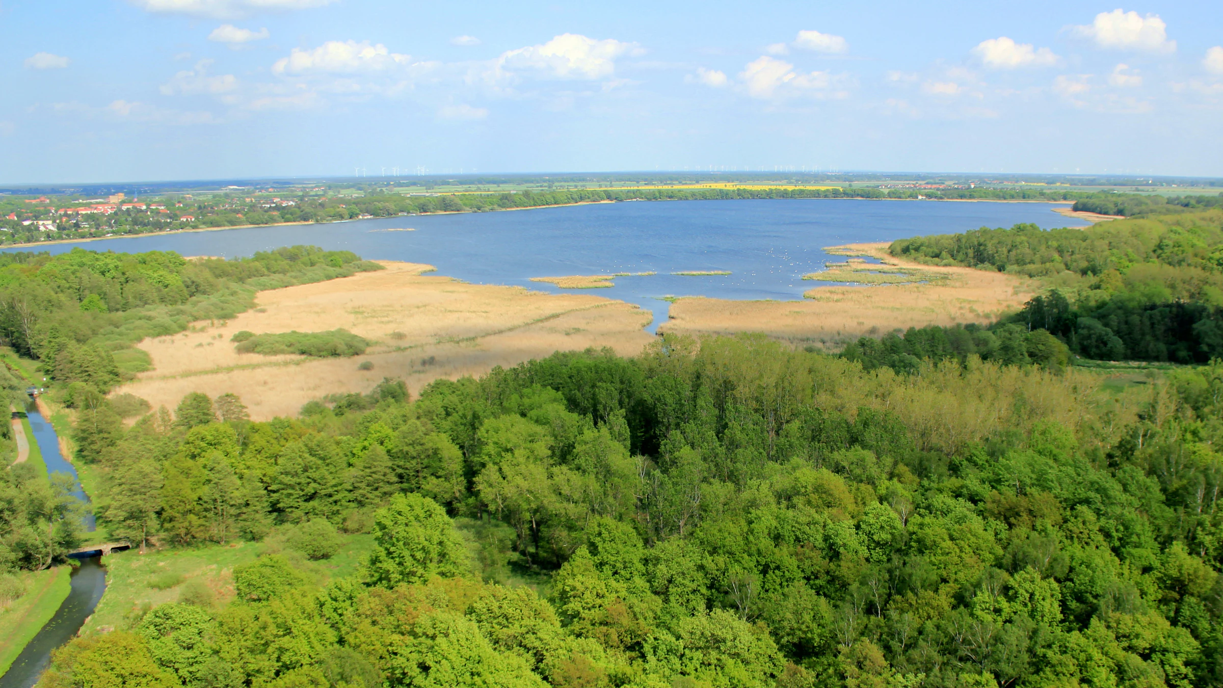
An aerial view showing a large lake surrounded by dense green forest and marshy yellow reeds.
An aerial view of the Großer Teich, showcasing its expansive water body and surrounding wetlands and forest.

Großer Teich Torgau history and protected-area timeline

The history of Großer Teich Torgau begins in the late medieval period, during a phase when the Electorate of Saxony was actively expanding its network of fish ponds to secure food supplies and support court life. The pond is traditionally associated with the years 1457, 1478, and 1483/84, with the most widely cited foundation being the kursächsisches Dekret of 1483 or 1484 that formally established it as a fish pond (Fischteich).

From early on the pond served more than a purely agricultural role. Because of its volume and proximity, it became a vital water reservoir for the Festung Torgau. The fortress relied on a continuous supply of water for its defensive moats, and the Großer Teich helped guarantee that supply, linking the rural pond system directly to the broader strategic infrastructure of Saxon defence.

The dam structure of approximately 800 metres, together with a controlled discharge, allowed the pond to be drained periodically so the fish could be harvested. Over time this practical cycle evolved into a fixed local tradition. Each November the Abfischen, the traditional fish harvest, takes place on the pond and remains a recognizable seasonal event in the Torgau region.

In the twentieth and twenty-first centuries the pond gradually gained additional importance as a protected natural area. Its surroundings were formally designated as a Naturschutzgebiet, and in 1995 the Naturschutzbund Deutschland established the Biberhof Torgau nature conservation station on the shore, giving the site an institutional base for ongoing ecological monitoring, education, and habitat management.

Großer Teich Torgau landscape and geographic character

Großer Teich Torgau sits in the gently undulating lowlands of northern Saxony, just south of the town of Torgau. The pond itself is broad and shallow, with a typical depth of only 1.5 to 2 metres, producing the open, calm water surface characteristic of historic Saxon fish ponds rather than a deep lake basin.

The water is retained by an earth-fill dam roughly 800 metres long and about five metres above the original valley floor. The dam itself is a defining visual landmark on the southern side of the pond, and its associated outlet structure functions as the controlled discharge point that allows the long-standing tradition of seasonal draining and fish harvesting.

Several small drainage channels (Gräben) feed the pond from the surrounding agricultural and woodland catchment, and the main outflow runs through the Schwarzer Graben and the Weinske toward the Elbe. The area around the pond carries the typical mosaic of a Saxon lowland pond landscape, with shallow water, marginal reed and marsh zones, wet meadows, and wooded buffer strips, all of which together form the visual and ecological setting of the protected area.
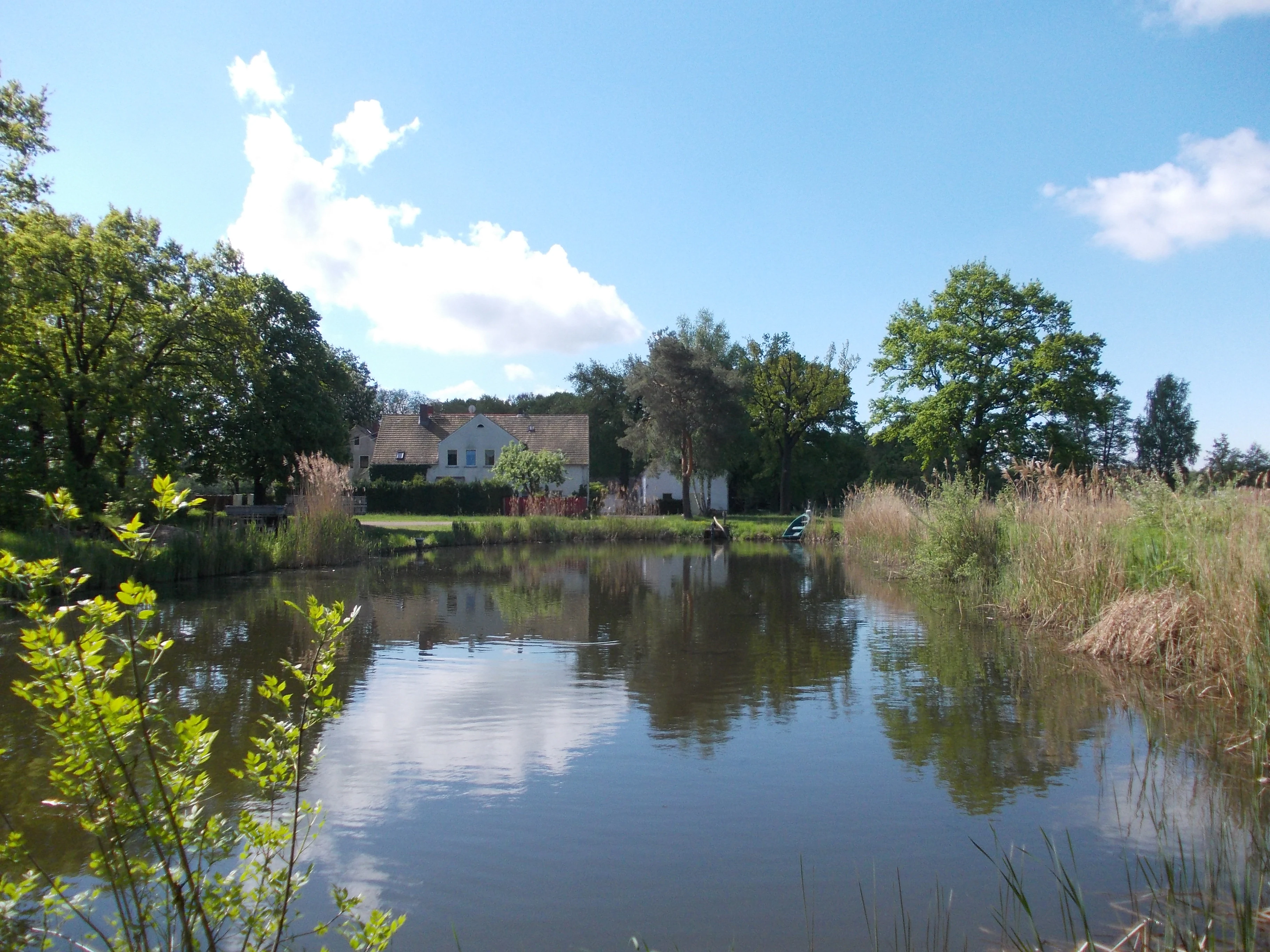
A peaceful lake surrounded by tall reeds and trees, with a white farmhouse-style building in the background under a blue sky with light clouds.
The Biberhof Torgau nature conservation station situated by the lake.

Großer Teich Torgau ecosystems, habitats, and plant life

Ecologically, Großer Teich Torgau functions as a managed wetland complex embedded in the broader Elbe tributary landscape of northern Saxony. The pond and its fringing zones together create a mosaic of open water, shallow marsh, reed beds, wet grassland, and wooded buffer, which is typical of older Saxon fish ponds that have been allowed to develop rich wetland vegetation alongside their continued agricultural use.

The surrounding Naturschutzgebiet extends outward from the water's edge and provides the protected habitat framework that supports wetland biodiversity. The shallow depth of the pond, the nutrient input from the surrounding catchment, and the periodic management of water levels all shape a system that is attractive to waterbirds, amphibians, insects, and typical lowland wetland flora.

The presence of the NABU Biberhof Torgau conservation station, established in 1995, indicates a continuing focus on maintaining and monitoring the ecological value of the site. The combination of historical water management and active conservation makes the pond an example of how a centuries-old artificial landscape can retain and even enhance its ecological significance in the modern era.

Großer Teich Torgau conservation status and protection priorities

The conservation significance of Großer Teich Torgau lies in its formal status as part of a designated Naturschutzgebiet within the Landkreis Nordsachsen. The protected designation covers the wetland margins and surrounding landscape around the pond, recognizing the ecological value of the water body, its reed zones, and the connected marsh and meadow habitats.

Institutional conservation work around the pond has a clear anchor: the NABU Biberhof Torgau nature conservation station, established by the Naturschutzbund Deutschland in 1995 on the shore of the pond. The presence of this center gives the site a long-term base for habitat management, species monitoring, environmental education, and ongoing collaboration with regional conservation planning.

Because the pond is simultaneously used for fish farming and flood protection, conservation here functions as part of a multi-use landscape. Rather than separating protection from human use, the site demonstrates how a historically managed water body can be integrated into modern conservation networks, contributing habitat value along the corridor between the Weinske, the Schwarzer Graben, and the Elbe.

Großer Teich Torgau cultural meaning and human context

The cultural identity of Großer Teich Torgau is closely intertwined with both the Saxon pond-building tradition and the military history of Torgau itself. The pond is a tangible survival of the late medieval kursächsische Teichwirtschaft, the fish-pond culture of the Electorate of Saxony, which shaped rural land use across the region in the fifteenth century.

Its long-standing function as a water reserve for the Festung Torgau gives the site an additional historical layer tied to Saxon fortification heritage. Over the centuries the annual November fish harvest, the Abfischen, became a recurring community tradition that still marks the seasonal rhythm around the pond today.

In the modern period the site also carries a clear environmental culture identity. Through the NABU Biberhof Torgau it has become a place for nature education and citizen engagement with wetland conservation, linking the working agricultural heritage of the pond to contemporary environmental values in northern Saxony.

Top sights and standout views in Großer Teich Torgau

Großer Teich Torgau stands out for the unusually long continuity of its use, stretching from a medieval Saxon fish pond in the 1480s to a still-operating fish farm and flood reservoir in the present day.

The site is also distinctive for the layered identity it carries: historic kursächsische pond engineering, military support infrastructure for the Festung Torgau, a living seasonal harvest tradition in the Abfischen, and a formal Naturschutzgebiet supported by the NABU Biberhof Torgau. Together these features make Großer Teich Torgau one of the more recognizable examples of an old Saxon Teich that continues to combine food production, flood management, recreation, and habitat protection in a single landscape.

Best time to visit Großer Teich Torgau

The most distinctive time to experience Großer Teich Torgau is late autumn, when the traditional Abfischen takes place on the pond each November. This seasonal fish harvest is a centuries-old practice and remains a culturally and visually notable moment in the pond's annual cycle, when the water level is drawn down and the fish are gathered from the historic reservoir.

Spring and summer are also relevant for visitors oriented toward the natural values of the site, when the wetland vegetation around the pond, the open water surface, and the surrounding Naturschutzgebiet are most visually active. The pond's recreational use, including swimming at the Strandbad Torgau area on its shore, is naturally aligned with the warmer months. Because the site functions as a protected area as well as a working fish farm, visits benefit from respecting seasonal and conservation considerations at any time of year.


Monthly climate preview

Long-term representative point measurements of temperature and precipitation rhythms in Saxony

Großer Teich Torgau Climate Normals and Annual Weather by Month

Historical climate data reveals the measured annual temperature and precipitation rhythm recorded at a representative coordinate within Großer Teich Torgau. Detailed monthly comparisons provide complete long-term meteorological normals across all twelve recorded intervals.
Annual mean9 °C
-1 °C20 °C
Jan-1°
Feb
Mar
Apr
May14°
Jun18°
Jul20°
Aug20°
Sep15°
Oct
Nov
Dec
Warmest month
July

20 °C

Coolest month
January

-0.7 °C

Wettest month
July

2.6 mm/day

Driest month
April

1.1 mm/day

Park location guide

Geography guide, regional context, and park location map for Großer Teich Torgau

Großer Teich Torgau park geography, regions, and map view in Germany

Understand where Großer Teich Torgau sits in Germany through a broader geographic reading of the surrounding landscape, nearby location context, and its mapped position within the national park landscape.

How Großer Teich Torgau fits into Germany

Germany is a federal republic in Western and Central Europe with a population of over 83 million across sixteen constituent states. It is Europe's largest economy by nominal GDP and a major global exporter and importer. The capital is Berlin, and the country borders Denmark, Poland, Czech Republic, Austria, Switzerland, France, Luxembourg, Belgium, and the Netherlands.

Wider geography shaping Großer Teich Torgau in Germany

Germany is located in Western and Central Europe, spanning 357,022 km². It borders Denmark to the north, Poland and the Czech Republic to the east, Austria and Switzerland to the south, and France, Luxembourg, Belgium, and the Netherlands to the west. The country has coastlines on the Baltic Sea and North Sea to the north, with the Alps located in the southern region.

Map view of Großer Teich Torgau

Use this park location map to pinpoint Großer Teich Torgau in Germany, understand its exact geographic position, and read its mapped placement within the surrounding landscape more clearly.

Pigeon | © OpenStreetMap contributors

Location context for Großer Teich Torgau

Saxony

Visualizing the historic Saxon pond terrain, wetlands, and conservation landscape

Großer Teich Torgau Photos: Scenery, Landscapes, and Protected Area Views

Browse detailed photographs capturing the open water surfaces, earth fill dam structures, and surrounding wetland mosaic of Großer Teich Torgau. Visual documentation reveals the distinct topography and habitat features of this long established protected area in Saxony.

An aerial view showing a large lake surrounded by dense green forest and marshy yellow reeds.

A green wooden park bench sits on the grassy bank beside a sandy beach bordering a calm, expansive lake under a clear blue sky, with willow trees standing along the shoreline.

A peaceful lake surrounded by tall reeds and trees, with a white farmhouse-style building in the background under a blue sky with light clouds.

Park atlas

Compare regional nature reserves, wetland habitats, and lowland conservation areas.

Other Parks Near Großer Teich Torgau And Surrounding Protected Landscapes

Visitors exploring Großer Teich Torgau can browse nearby protected areas and regional lowland nature reserves. Continuing through connected wetland landscapes provides broader geographic context for Saxon conservation zones.
Nature reserveBrandenburg
About 23 km away#1 closest

Northeast

Alte Elster und Rieke: Protected Floodplain and River Geography in Brandenburg

Nature reserve featuring old river arms and wetland mosaics.

The Alte Elster und Rieke nature reserve represents one of the few surviving near-natural floodplain remnants along the Schwarze Elster river. This area supports a rich network of ponds, reed beds, and wet meadows that serve as a crucial refuge for wetland plants and wildlife within the otherwise heavily regulated Elbe-Elster lowland landscape.

Area
1.756 km²
Established
1981
IUCN
IV
Relief
Lowland
Nature reserveSaxony
About 26 km away#2 closest

West

Vereinigte Mulde Eilenburg, Bad Düben: Protected Floodplain Landscapes of Saxony

Riparian river geography and protected meadow corridors

Spanning over 1,400 hectares along the Mulde river, this nature reserve in Nordsachsen preserves an essential lowland river system. The protected area encompasses diverse riparian forests, oxbow features, and flood meadows that define the natural character of the unified Mulde valley between the towns of Eilenburg and Bad Düben.

Area
14.53 km²
Established
2001
IUCN
IV
Relief
Lowland
A soft watercolor painting depicting a pale, hazy landscape with green grassy fields, light green trees, and distant faint mountains under a pastel sky.
Protected areaSaxony
About 26 km away#3 closest

Southeast

Gohrischheide und Elbniederterrasse Zeithain: Geography and Protected Area Overview

Analyzing the inland dunes and dry heath landscape of the Elbe river terrace

Discover the unique geography of Gohrischheide und Elbniederterrasse Zeithain in Saxony, a protected area known for its expansive inland dunes and dry heath habitats. This region represents a rare combination of post-glacial sand landscapes and semi-open forest mosaics that reflect long-term ecological evolution and distinct regional environmental conditions.

Area
28.47 km²
Established
2011
Relief
Lowland
Climate
Temperate
A horizontal watercolor painting showing a soft, atmospheric wetland scene with green meadows, tall grasses, distant tree lines, and a pale pink and yellow sky.
Nature reserveBrandenburg
About 27 km away#4 closest

East

Kleine Röder Nature Reserve: Mapped Wetland Geography and Protected Landscape in Brandenburg

A vital Elbe-Mulde lowland corridor near Bad Liebenwerda

The Kleine Röder Nature Reserve functions as a major ecological link in northeastern Germany, protecting a 385 hectare mosaic of fens, wet meadows, and alluvial forests. This site is defined by its water-dominated terrain and its role as a habitat corridor in the Elbe-Mulde lowland, encompassing both rare wetland flora and the historic Kosilenzien Slavic ringwall within its official boundaries.

Area
3.65 km²
Established
2011
IUCN
IV
A minimalist watercolor painting showing a horizontal landscape with patches of green forest and hints of marshy or open terrain against a white background.
Protected landscapeBrandenburg
About 40 km away#5 closest

East

Naturpark Niederlausitzer Heidelandschaft: A Protected Landscape in Brandenburg

Mapping the glacial remnants and industrial heritage of a German lowland nature park

Naturpark Niederlausitzer Heidelandschaft offers an insightful look into the transformation of Brandenburg lowlands, where sessile oak forests, wet meadows, and post mining residual waters create a singular ecological mosaic. This destination captures the contrast between remnants of the last ice age and the deliberate rewilding of former opencast pits, providing a deep view into regional landscape evolution.

Area
484.3 km²
Established
1996
Relief
Lowland
Climate
Temperate
A horizontal watercolor illustration showing soft green rolling hills, trees, and a pale yellow sky.
Nature reserveSaxony
About 41 km away#6 closest

Southwest

Alte See, Ruhmberg Nature Reserve: Geographic Atlas of a Protected Landscape in Saxony

Ecological recovery of former military sites in the German lowlands.

Situated in the Landkreis Leipzig, the Alte See, Ruhmberg nature reserve offers a complex study in land use and conservation. The protected area features a unique transition between alder carr wetlands along the Parthe river and the dry, open grasslands of the Ruhmberg hill, creating a high-density biodiversity hotspot within the broader context of Saxon geography.

Area
2.66 km²
Established
2015
IUCN
IV
Nature reserveBrandenburg
About 42 km away#7 closest

Northeast

Lehmannsteich Nature Reserve: Geographic Atlas of Brandenburg Protected Lowlands

Atlantic wet heath and bog-hollow conservation landscapes.

Discover the complex landscape of Lehmannsteich, a 140-hectare nature reserve in Brandenburg. This protected area showcases a distinctive transition from wet heath and peat-filled sloughs to surrounding pine woodland, illustrating the rare inland habitat types found within the Elbe-Elster region.

Area
1.405 km²
Established
1981
IUCN
IV
Nature reserveSachsen
About 43 km away#8 closest

South

Scheergrund Nature Reserve: Geographic Atlas and Protected Landscape Overview

Mapping the geology and woodland history of the Leisnig region

Scheergrund functions as a vital nature reserve and geological reference site within the Saxon landscape. This area provides insight into Holocene tufa systems, ancient dam structures, and the complex interplay between spring-fed stream morphology and human development in the Freiberger Mulde tributary valley.

Area
0.578 km²
Established
1961
IUCN
IV

Common questions about visiting, size, designation, and location context for Großer Teich Torgau

Großer Teich Torgau FAQs for park facts, access, geography, and protected area context

Find quick answers about Großer Teich Torgau, including protected-area facts, park geography, trail and visitor context, and how the park fits into its surrounding country and regional landscape.
MoriAtlas Explorer

Continue Your Protected Areas Search Across the Global Atlas

Deepen your exploration by continuing the structured search for national parks and protected areas worldwide. Utilize the comprehensive filtering capabilities to compare different conservation landscapes and refine your understanding of global park geography. Discover more about the distribution and characteristics of protected natural areas.

Global natural geography