

Why Honberg stands out
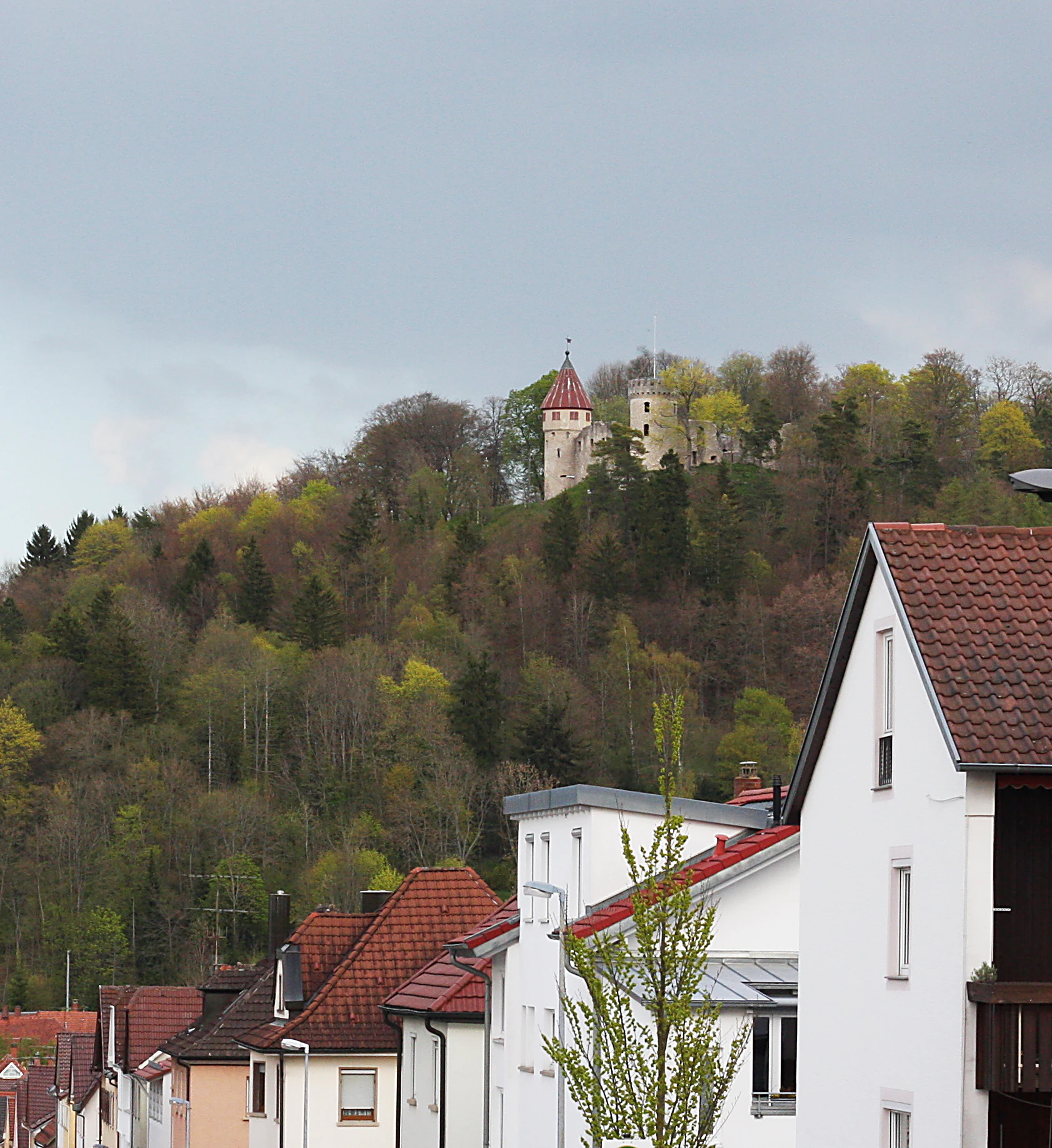
The Honberg is best known as a classic example of a Danube Umlaufberg, a ridge encircled by a former meander of the river, now completely surrounded by the built-up area of Tuttlingen. Equally distinctive is the combination of a medieval castle ruin with a designed park on the plateau, a partly wooded north slope with allotment gardens, a sheep-grazed south slope, and orchard meadow on the upper surface, all preserved as a single small landscape protection area within a working town. The hill is also recognized in regional geological literature for exposing the layered Upper Jurassic limestones of the Swabian Jura.
Honberg history and protected-area timeline
The Honberg has a layered history that combines natural landscape formation with centuries of human use and, more recently, formal conservation protection. The hill itself was formed by the meandering Danube, which once flowed around it before cutting a shorter valley path and leaving the former course, and with it the hill, as an isolated Umlaufberg. On its plateau, medieval builders constructed Honberg Castle, now preserved as ruins and integrated into a park that serves as the hill's main visitor feature.
The first formal protection of the Honberg landscape dates to 1944, when the area was placed under an earlier landscape protection order. That older ordinance was superseded when the Landratsamt Tuttlingen, on 3 February 1986, issued a new designation formally establishing the Landschaftsschutzgebiet Honberg that exists today. The site's inclusion in the Naturpark Obere Donau situates it within a broader regional landscape protection framework spanning the Upper Danube valley. Through these successive steps, the Honberg has moved from being simply a hill with a castle ruin into a documented protected landscape at the heart of Tuttlingen.
Honberg landscape and geographic character
The Honberg is a long, narrow ridge whose outline clearly reflects its origin as a former meander of the Danube. As an Umlaufberg, it has the characteristic elongated form of a hill that once lay inside a river bend, and it now rises above the flat valley floor of Tuttlingen as a distinct topographical feature within the town. Its slopes show a clear pattern of use: woodland on parts of both the north and south slopes, allotment gardens on the north, and open sheep pasture on the south. The plateau is flatter and is used as grassland, partly planted with fruit trees, while the ridge itself is marked by a prominent row of trees that follows the path running along the top.
Geologically, the hill belongs to the Upper Jurassic formations of the Swabian Jura. The plateau is capped by the Untere Felsenkalke (Lower Massive Limestone), which gives way on the slopes to the softer Lacunosa-Formation, and below that to the Wohlgeschichtete Kalke (Well-bedded Limestone) at the base. This layered structure is typical of the limestone scenery along the Upper Danube and contributes to the stepped profile of the hill. Surrounding the hill, the landscape transitions directly into the densely built fabric of Tuttlingen, making the boundary between protected natural area and urban streetscape unusually sharp.
Honberg ecosystems, habitats, and plant life
Despite its small size and urban setting, the Honberg supports a varied mosaic of near-natural and semi-natural habitats. The wooded portions of both the north and south slopes provide continuous tree cover across significant parts of the hill, while the open plateau is dominated by grassland, including orchard meadows with scattered fruit trees. These orchard meadows are among the more ecologically valuable elements, combining open meadow species with the structural diversity of mature fruit trees.
The hill's allotment-garden areas on the north slope and the sheep pasture on the south slope add further structural variety, while the tree-lined ridge that runs along the top of the hill acts as both a visual green corridor and a biological link between the wooded slopes. Because the hill lies within the Naturpark Obere Donau and the natural region of the Baaralb and Upper Danube Valley, its habitat mosaic can be read as a small-scale sample of the broader Upper Danube landscape, with limestone woodland, dry grassland tendencies, and orchard meadow patterns characteristic of the Swabian Jura.
Honberg conservation status and protection priorities
The Honberg's conservation value lies primarily in its role as a small but well-defined landscape protection area embedded within the urban fabric of Tuttlingen. Designated under IUCN Category V as a Protected Landscape/Seascape, its purpose is to maintain the combined natural and cultural character of the hill rather than to set aside pure wilderness. The protected status, established by the Landratsamt Tuttlingen in 1986, replaced an earlier 1944 order and continues to preserve the hill's mosaic of woodland, pasture, orchard meadow, and allotments together with the castle ruin and its park.
By linking explicitly to the Naturpark Obere Donau, the Honberg also contributes to a wider regional conservation network along the Upper Danube, helping to maintain continuity of limestone-associated habitats across the valley. Its protected designation recognizes that even very small landscape features, where they illustrate valley formation, local history, and traditional land use, can carry disproportionate regional conservation significance.
Honberg cultural meaning and human context
The Honberg carries a strong cultural identity rooted in both its medieval and its everyday local use. The Burgruine Honberg on the plateau is a defining historical landmark of Tuttlingen and the visual anchor of the hill, while the surrounding park extends the site's role as a public gathering and walking space for residents. Traditional land uses, including sheep grazing on the south slope and orchard meadow management on the plateau, connect the current protected landscape to older rural practices that once characterized the whole Upper Danube valley.
Allotment-style small gardens on the north slope reflect a more recent, but now long-established, layer of urban-rural interaction, in which the hill has become a green commons for the surrounding city. Together, these elements, medieval castle, designed park, pasture, orchard, allotment, and woodland, give the Honberg a layered cultural character that is unusual for a protected area of its size.
Top sights and standout views in Honberg
Among the Honberg's most distinctive qualities are its identity as a Danube Umlaufberg preserved at the heart of an urban area, the combination of castle ruin and park on its plateau, and its unusually varied land-use mosaic of woodland, sheep pasture, orchard meadow, and allotment gardens within a single small hill. The site's layered protection history, from a 1944 ordinance to the current 1986 designation, and its position within the Naturpark Obere Donau, add further institutional weight to an otherwise modest-looking protected landscape.
