

Mori Atlas logo
State or regional parkHorneline Creek Provincial Park

Discover the glacial terrace formations and mineral-rich habitats of this remote British Columbia backcountry refuge.

Horneline Creek Provincial Park: Protected Canyon Landscapes and Rocky Mountain Trench Geography

Horneline Creek Provincial Park protects a distinct canyon ecosystem carved into an ancient glacial terrace within the northern reaches of the Rocky Mountain Trench. This protected area in British Columbia serves as a vital geological landmark, exposing mineral-rich substrate that creates natural licks for local ungulates. The surrounding landscape, characterized by a transition from rugged gorge walls to open aspen-lined grasslands, provides an essential window into the post-glacial history of the region.

provincial parkBritish ColumbiaRocky Mountain TrenchKechika Rivercanyonglacial terrace

Horneline Creek Provincial Park

State or regional park

Park overview

Structured park overview, official facts, and landscape profile for Horneline Creek Provincial Park

Horneline Creek Provincial Park park facts, protected area profile, and essential visitor context

Review the core facts for Horneline Creek Provincial Park, including designation, size, terrain, visitor scale, habitats, and operating context in one park-focused overview.

About Horneline Creek Provincial Park

Horneline Creek Provincial Park sits in the remote northern reaches of British Columbia, in a landscape shaped by the geological forces that defined the nearby Rocky Mountain Trench. The surrounding region is built around the broad, glacially sculpted valleys of the Kechika River and its tributaries, where ancient river terraces and glacial deposits still define much of the topography. Within this setting, the park focuses on a single, very specific feature: the canyon valley of Horneline Creek and its relationship with the wildlife that depends on it.

Although the park covers a relatively modest area, its protection is ecologically targeted rather than comprehensive. The canyon walls remain steep enough to deter casual intrusion, and the mineral deposits exposed where the creek has cut through the glacial terrace have become a focal point for local wildlife. The mix of open grassland on the rim, trembling aspen groves, and the sheer mineral-stained canyon walls gives the park an unusual vertical and ecological layering for such a small footprint. Because access requires either a long river journey along the Kechika or a strenuous overland approach, the park tends to be visited primarily by experienced backcountry travelers, river guides, and wildlife enthusiasts rather than casual visitors.

The park's significance is closely tied to the broader network of protected and wild lands that characterize northern British Columbia, including its neighbor Denetiah Provincial Park to the south and the historic Davie Trail that runs along the Kechika River. Together, these areas help preserve a continuum of relatively undisturbed wildlife habitat along the Rocky Mountain Trench. Within that broader regional context, Horneline Creek stands out as a small but unusually specific refuge, built around a single canyon, a single mineral lick, and one of the most emblematic mountain ungulates of the northern Cordillera.

Quick facts and research context for Horneline Creek Provincial Park

Horneline Creek Provincial Park is a small, roughly 298 hectare provincial park in the Cassiar Land District of British Columbia, managed by BC Parks and classified under IUCN Category II. It was established on June 28, 1999, and lies west of the Kechika River in a remote corner of the province's far north, near the community of Liard River. The park's principal conservation focus is mountain goat habitat, broadly representative of the wildlife patterns along the Rocky Mountain Trench and its tributary valleys.

Protection and recognition

Examine documented terrestrial protection parameters and official designation records for Horneline Creek Provincial Park.

Horneline Creek Provincial Park Protection Status and Mapped Conservation Scope

Terrestrial protection status and designation parameters for Horneline Creek Provincial Park appear alongside verified conservation scope records. Structured management data provides clear geographic insight into regional protected area administration.

Protection details

Protection scope
Terrestrial
Transboundary protection
No
Park context

Deeper park guide and search-rich context for Horneline Creek Provincial Park

Horneline Creek Provincial Park history, landscape, wildlife, and travel context

Explore Horneline Creek Provincial Park through its history, landscape character, ecosystems, wildlife, conservation priorities, cultural context, and seasonal travel timing in a structured park guide built for atlas discovery and search intent.

Why Horneline Creek Provincial Park stands out

The park is best known for the steep-walled canyon that Horneline Creek has carved into an ancient glacial terrace, and for the natural mineral lick that this canyon exposes. This lick draws large seasonal aggregations of mountain goats, making the canyon one of the more reliable places in the region to observe goats at close range without artificial feeding. The unusual pairing of canyon topography, exposed mineral substrate, and adjacent aspen and grassland habitats gives the park a concentrated and distinctive ecological character.

Horneline Creek Provincial Park history and protected-area timeline

Horneline Creek Provincial Park was formally established on June 28, 1999, as part of British Columbia's ongoing effort to protect representative natural areas in the province's remote north. The park was created under the provincial parks system administered by BC Parks, with an IUCN Category II designation that reflects a protection standard comparable to that of national parks.

The area's history of human use runs deeper than its formal protection status. The nearby Kechika River corridor was historically traveled by the Davie Trail, a route connecting Fort Ware to Lower Post that supported early travel, trade, and indigenous movement through the Rocky Mountain Trench. The park was designated well after this trail era had ended, but its location along the same river corridor preserves that broader human history in the surrounding region. Modern use of the park is closely tied to long-distance river travel along the Kechika, with a roughly 250 kilometer boat trip from Fireside commonly used to reach the general area.

Horneline Creek Provincial Park landscape and geographic character

The dominant physical feature of Horneline Creek Provincial Park is the steep-walled canyon that the creek has incised into an old glacial terrace. This canyon is the park's central geological element, and its sheer mineral-stained walls contrast sharply with the gentler terrain that surrounds it on the rim. The terrace above the creek represents a legacy of Pleistocene glaciation, with the modern creek acting as a relatively recent erosional force cutting back down through these older deposits.

Around the canyon rim, the landscape shifts to a softer character. Open grasslands break up the forest cover, and discrete stands of aspen bring a deciduous layer to terrain that would otherwise be dominated by coniferous boreal and sub-boreal forest typical of the Rocky Mountain Trench. The result is a small but visually varied park, where the vertical drop of the canyon, the mineral exposed along its walls, the grassy plateaus above, and the white-barked aspen groves all combine into a compact and easily readable landscape. Because the park lies close to the broad valley of the Kechika River, visitors approaching by boat also see the wider trench landscape of benchlands, river flats, and forested slopes that frame this small protected enclave.

Horneline Creek Provincial Park ecosystems, habitats, and plant life

Ecologically, Horneline Creek Provincial Park sits within the broader sub-boreal and boreal transition zones of northern British Columbia, where coniferous forest cover is interrupted by river terraces, grasslands, and post-glacial features. The park's vegetation reflects this transition at a small scale: coniferous woodland typical of the surrounding region gives way to pockets of aspen along the canyon rim and to grassy openings where soils and exposure favor herbaceous plants over trees. This mosaic creates more ecological variety than the park's modest size would otherwise suggest.

The mineral lick at the heart of the canyon is the ecological pivot of the entire park. Such licks are critically important in mountain ecosystems because they supply minerals that are otherwise scarce in the local diet, and they concentrate wildlife usage into a small, predictable area. Around the lick, the plant community and mineral exposure conditions interact to create a habitat that is attractive to ungulates and, by extension, to the predators and scavengers that follow them. The park thus functions less as a broad habitat preserve and more as a targeted refuge for one important ecological process within the larger Rocky Mountain Trench ecosystem.

Horneline Creek Provincial Park wildlife and species highlights

Mountain goats are the central wildlife focus of Horneline Creek Provincial Park, and the canyon's mineral lick has been observed to attract groups of 60 to 75 goats at a time. These aggregations reflect the lick's importance as a mineral resource in an otherwise mineral-limited landscape, and they make the canyon one of the more significant goat concentration sites in the region. Because the goats favor the steep, rocky walls of the canyon itself, they are often seen at close range but on near-vertical terrain that reinforces their image as climbers of extreme mountain environments.

Although mountain goats are the headline species, the surrounding mosaic of forest, grassland, and aspen stands supports a wider community of northern wildlife typical of the Kechika River valley. The park's role as a refuge along a longer wild river corridor means that species moving through the broader Rocky Mountain Trench may also pass through or near the park, even if the park itself is not large enough to support permanent populations of larger predators or wide-ranging mammals. In this sense, Horneline Creek functions as a small but targeted node within a much larger network of mountain and boreal habitat in northern British Columbia.

Horneline Creek Provincial Park conservation status and protection priorities

The principal conservation value of Horneline Creek Provincial Park lies in its protection of a specific and ecologically important mineral lick and its surrounding canyon habitat. Mineral licks are limited and fragile features in mountain ecosystems, and protecting the canyon walls and the access terrain around this one helps ensure that one of the region's important goat gathering sites remains undisturbed. The park's IUCN Category II status, equivalent in protection philosophy to a national park, reflects this conservation intent rather than its physical size.

At a broader scale, the park contributes to a network of protected areas along the Kechika River and the Rocky Mountain Trench, including nearby Denetiah Provincial Park. This regional network helps maintain landscape connectivity for mountain ungulates and other northern wildlife in an area where industrial pressures, although limited compared to southern British Columbia, still represent long-term considerations. By keeping a remote and ecologically specific site off-limits to development, Horneline Creek adds a small but meaningful piece to the conservation fabric of the province's far north.

Horneline Creek Provincial Park cultural meaning and human context

The cultural context of Horneline Creek Provincial Park is tied primarily to the long history of travel through the Kechika River corridor. The Davie Trail, a historic overland route that once connected Fort Ware to Lower Post, follows part of the Kechika River next to the Rocky Mountain Trench and represents an important chapter in the region's non-indigenous travel history. The park sits within this same corridor of historical movement, even though the trail itself lies just beyond the park's boundaries.

The Kechika River and its tributaries have long been part of indigenous travel, hunting, and trading networks across northern British Columbia, and the broader landscape around the park continues to hold cultural significance for first nations in the region. The park itself is small and ecologically focused rather than culturally focused, but its setting within a long-used river valley means that visitors often encounter the cultural layers of the region through nearby communities, historic routes, and the wider land use patterns of the trench.

Top sights and standout views in Horneline Creek Provincial Park

The standout feature of Horneline Creek Provincial Park is the steep mineral-stained canyon carved by Horneline Creek into a glacial terrace, home to a mineral lick that draws large numbers of mountain goats. Surrounding grasslands and aspen stands along the canyon rim provide a visually striking contrast to the rugged gorge below and offer a glimpse into the post-glacial processes that shaped the broader Rocky Mountain Trench. For travelers willing to make the long river or overland approach, the park offers a concentrated and unusually focused wildlife experience within one of the most remote corners of British Columbia.

Best time to visit Horneline Creek Provincial Park

Because Horneline Creek Provincial Park is accessed primarily by river boat along the Kechika or by foot, the most favorable conditions for a visit typically align with the broader northern British Columbia backcountry season, when rivers are open enough for travel, footing is firmer, and wildflower and grass growth along the canyon rim is at its peak. Summer and early fall generally offer the most reliable combination of accessible waterways and warmer temperatures, and they also coincide with the period when mountain goats make the heaviest use of mineral licks.

Winter conditions significantly complicate access, with frozen rivers, deep snow, and extreme cold making both the boat approach and any overland travel impractical for most visitors. Wildlife viewing of mountain goats can still be dramatic in colder months for those equipped for winter travel, but the park is most realistically visited as part of a summer or early autumn expedition along the Kechika corridor. Visitors planning a trip generally benefit from timing their journey to match the broader rhythms of this remote and weather-sensitive landscape.
Monthly climate preview

Long term monthly temperature and precipitation patterns recorded at park coordinates

Horneline Creek Provincial Park Climate Normals and Annual Temperature Rhythm

Horneline Creek Provincial Park exhibits a measured annual temperature range spanning severe winter lows and moderate summer highs alongside recorded monthly precipitation variations. Examining the complete twelve month profile provides detailed climatological context for researchers studying long term regional weather patterns.
Annual mean-3 °C
-17 °C12 °C
Jan-17°
Feb-14°
Mar-11°
Apr-3°
May
Jun10°
Jul12°
Aug10°
Sep
Oct-2°
Nov-12°
Dec-16°
Warmest month
July

11.8 °C

Coolest month
January

-17.2 °C

Wettest month
June

2.8 mm/day

Driest month
February

0.9 mm/day

Park location guide

Geography guide, regional context, and park location map for Horneline Creek Provincial Park

Horneline Creek Provincial Park park geography, regions, and map view in Canada

Understand where Horneline Creek Provincial Park sits in Canada through a broader geographic reading of the surrounding landscape, nearby location context, and its mapped position within the national park landscape.

How Horneline Creek Provincial Park fits into Canada

Canada is a federal parliamentary constitutional monarchy spanning North America from the Atlantic to the Pacific and Arctic Oceans. With a population of over 41 million, it is officially bilingual in English and French at the federal level. The country gained independence from the United Kingdom through a gradual process culminating in 1982.

Wider geography shaping Horneline Creek Provincial Park in Canada

Canada occupies the northern portion of North America, sharing its longest international border with the United States. The country extends from the Atlantic Ocean to the Pacific Ocean and northward into the Arctic Ocean, giving it the longest coastline of any nation.

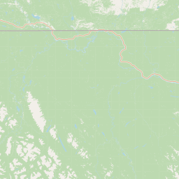
Map view of Horneline Creek Provincial Park

Use this park location map to pinpoint Horneline Creek Provincial Park in Canada, understand its exact geographic position, and read its mapped placement within the surrounding landscape more clearly.

Pigeon | © OpenStreetMap contributors

Location context for Horneline Creek Provincial Park

British Columbia
Park atlas

Compare adjacent northern wilderness reserves and remote regional valley terrain

Other Parks Near Horneline Creek Provincial Park and Surrounding Protected Landscapes

Browsing other protected areas near Horneline Creek Provincial Park reveals broader ecological patterns across the northern Rocky Mountain Trench. Examining these neighboring wilderness territories provides valuable regional context for remote northern British Columbia ecosystems.
State or regional parkBritish Columbia
About 30 km away#1 closest

South

Denetiah Provincial Park and Protected Area: Regional Geography and Wilderness Mapping

An undisturbed boreal reserve in the Stikine Region

Discover the geographic structure of Denetiah Provincial Park and Protected Area, a vast roadless landscape in northern British Columbia. This park protects pristine boreal forests, elongated glacial lake basins, and critical river headwaters that serve as a benchmark for northern conservation within the Muskwa-Kechika Management Area.

Area
1,053.49 km²
Established
1999
IUCN
II
Relief
Upland
A pale, minimalist watercolor painting of a river landscape with distant rolling hills, marshy grasses, and light tree clusters under a bright sky.
State or regional parkBritish Columbia
About 83 km away#2 closest

Northeast

Liard River Hot Springs Provincial Park: Boreal Geothermal Mapping and Regional Geography

Protected northern wilderness, thermal water systems, and muskeg wetland terrain

Liard River Hot Springs Provincial Park serves as a protected geographic nexus where thermal water discharge creates a unique biological oasis. The park landscape combines expansive boreal forest with sensitive muskeg wetlands, centered around a natural hot spring system that supports orchid populations and regular wildlife sightings. This atlas entry provides essential context on the physical boundaries and ecological features that define this significant regional park in northern British Columbia.

Area
10.82 km²
Established
1957
IUCN
III
Relief
Lowland
State or regional parkBritish Columbia
About 88 km away#3 closest

Southeast

Dune Za Keyih Provincial Park and Protected Area: Watershed and Terrain Geography

Remote wilderness landscape in northern British Columbia

Dune Za Keyih Provincial Park and Protected Area protects the largest unlogged watershed in British Columbia. Situated within the Muskwa-Kechika Management Area, this remote wilderness is defined by the geological structures of the Rocky Mountain Trench, providing a continuous corridor of undisturbed mountain forest, riparian zones, and highland terrain.

Area
3,468.33 km²
Established
2001
IUCN
Ib
Relief
Mountain
State or regional parkBritish Columbia
About 163 km away#4 closest

Southeast

Kwadacha Wilderness Provincial Park: Geographic Boundaries and Regional Protected Area Context

Untouched mountain wilderness in northern British Columbia

Kwadacha Wilderness Provincial Park provides a rare, roadless mountain experience within the northeastern interior of British Columbia. Characterized by high-relief alpine ridges, dense boreal forests, and challenging river systems, the park represents an essential wilderness corridor that remains free from human infrastructure and standard road access, prioritizing ecological integrity over recreation.

Area
1,302.79 km²
Established
1973
IUCN
Ib
Relief
Mountain
State or regional parkBritish Columbia
About 174 km away#5 closest

South

Finlay-Russel Provincial Park and Protected Area: Mapping Northern British Columbia Wilderness

A remote river corridor in the Muskwa-Kechika Management Area.

Located in northern British Columbia, Finlay-Russel Provincial Park and Protected Area preserves an essential 85-kilometre river corridor along the Finlay River. This expansive wilderness territory serves as an integral part of the Muskwa-Kechika Management Area, showcasing deep boreal forest landscapes and rugged river valley terrain far from established road networks.

Area
1,092.05 km²
Established
2001
IUCN
II
Access
Remote access
Nature reserveBritish Columbia
About 182 km away#6 closest

Southwest

Gladys Lake Ecological Reserve: Remote Wilderness and Alpine Geography in British Columbia

Scientific reference area on the Spatsizi Plateau

Explore the expansive geography of Gladys Lake Ecological Reserve, a major protected area located in the remote interior of British Columbia. This reserve provides a strictly preserved natural landscape defined by high-elevation ridges, subalpine transitions, and the pristine wilderness of the Eaglenest Range, serving as a benchmark for ecological research in Canada.

Area
440.98 km²
Established
1975
IUCN
Ia
Relief
Mountain
National parkNorthwest Territories
About 198 km away#7 closest

North

Nahanni National Park Reserve National Park: Protected Landscape and Geographic Mapping

Explore the mapped terrain and protected area boundaries in Northwest Territories.

Navigate the protected landscape of Nahanni National Park Reserve, a designated national park within the Northwest Territories. This entry provides detailed insight into the park's mapped geographic boundaries and its role as a significant protected area. Understanding its place within the regional atlas allows for a deeper appreciation of its natural terrain and conservation significance, offering factual context for geographic exploration.

Area
30,050 km²
Established
1972
IUCN
II
Visitors
1.1K annual
State or regional parkBritish Columbia
About 227 km away#8 closest

East

Jackpine Remnant Provincial Park: Protected Boreal Landscape and Regional Map Context

Conservation and terrain data for the Fort Nelson region

Jackpine Remnant Provincial Park provides a critical study in northern conservation geography. Located in the Fort Nelson area of British Columbia, this 148-hectare site protects a rare stand of jack pine trees. Its mapped boundaries and boreal forest terrain offer a focused look at small-scale protected landscapes and their significance within the broader regional ecosystem of the Canadian north.

Area
1.48 km²
Established
2001
IUCN
II
Relief
Lowland

Common questions about visiting, size, designation, and location context for Horneline Creek Provincial Park

Horneline Creek Provincial Park FAQs for park facts, access, geography, and protected area context

Find quick answers about Horneline Creek Provincial Park, including protected-area facts, park geography, trail and visitor context, and how the park fits into its surrounding country and regional landscape.
MoriAtlas Explorer

Continue Your Protected Areas Search Across the Global Atlas

Deepen your exploration by continuing the structured search for national parks and protected areas worldwide. Utilize the comprehensive filtering capabilities to compare different conservation landscapes and refine your understanding of global park geography. Discover more about the distribution and characteristics of protected natural areas.

Global natural geography