
Mori Atlas logo
Protected landscapeHumboldt–Toiyabe National Forest

Tracing the geographic reach of America's largest contiguous-state national forest across Nevada mountain ranges

Humboldt–Toiyabe National Forest: Mapping a Discontinuous Protected Landscape Across the American West

Humboldt–Toiyabe National Forest defines the high-country geography of the Great Basin through a vast, discontinuous network of mountain ranges and protected wilderness areas. Spanning from the Santa Rosa Range in northern Nevada to the alpine heights of the Spring Mountains near Las Vegas, this massive reservation reaches across the state line into eastern California. By mapping these isolated mountain blocks, the forest reveals a complex assembly of glaciated canyons, high-elevation sky islands, and subalpine meadows separated by broad desert basins.

national forestGreat Basinalpine wildernessmountain rangesNevadaeastern California
A flat-style digital illustration depicting a mountain valley with a central lake surrounded by evergreen forests and rolling green hills under a soft sun.

Humboldt–Toiyabe National Forest

Protected landscape

Park overview

Structured park overview, official facts, and landscape profile for Humboldt, Toiyabe National Forest

Humboldt, Toiyabe National Forest park facts, protected area profile, and essential visitor context

Review the core facts for Humboldt, Toiyabe National Forest, including designation, size, terrain, visitor scale, habitats, and operating context in one park-focused overview.

About Humboldt, Toiyabe National Forest

Humboldt–Toiyabe National Forest represents one of the most geographically unusual units in the U.S. National Forest System. Instead of forming a continuous swath of public land, it sprawls across Nevada in numerous non-contiguous sections, threading through many of the state's mountain ranges from the Santa Rosa Range near the Oregon border to the Spring Mountains just west of Las Vegas. About 11 percent of the forest lies across the state line in eastern California, including the areas around Bridgeport, Markleeville, and other lands west of the Sierra Nevada. This patchwork structure reflects how Nevada's basin-and-range topography naturally divides land into distinct upland blocks separated by desert basins.

The forest is divided into seven ranger districts, each centered on a different Nevada mountain area: Austin, Bridgeport, Carson, Ely, Jarbidge, Mountain City, and the merged Ruby Mountains district covering the Ruby Mountains and East Humboldt Range. The Spring Mountains National Recreation Area near Las Vegas operates as a distinct management unit within the forest. Forest headquarters are located in Sparks, Nevada, near Reno in the northwestern corner of the state.

The Humboldt portion takes its name from the Prussian polymath Alexander von Humboldt, whose scientific expeditions in the Americas helped define early 19th-century geographic and natural history exploration. The Toiyabe portion takes its name from a Native American word, reflecting the deep Indigenous history of the region. Despite being joined administratively in 1995, the two forests remain legally and geographically separate, each preserving its own ranger districts and identity.

Humboldt–Toiyabe is also significant for the sheer scale of its protected wilderness. It hosts more than two dozen designated wilderness areas, including several of the most celebrated wild landscapes in the Great Basin, such as the Ruby Mountains, Jarbidge, East Humboldt, Alta Toquima, Arc Dome, and the Spring Mountains' Mount Charleston Wilderness. These areas preserve high-elevation ecosystems, glacial carved canyons like Lamoille Canyon, and ancient bristlecone pine stands that contrast dramatically with the surrounding arid lowlands.

Quick facts and research context for Humboldt, Toiyabe National Forest

Humboldt–Toiyabe National Forest covers roughly 6.3 million acres spread across Nevada and a portion of eastern California, making it the largest national forest in the lower 48 states. It encompasses seven ranger districts and lies within 13 Nevada counties and 6 California counties, with headquarters near Reno in Sparks, Nevada.

The forest originated from two separate reserves: Humboldt National Forest, established in 1908, and Toiyabe National Forest, established in 1907, the latter taking its name from a Native American word. The two forests were administratively combined in 1995 but remain legally and geographically distinct units under U.S. Forest Service management.

Protection and recognition

Documented management scope, terrestrial protection status, and transboundary features

Humboldt–Toiyabe National Forest Protection Status and Terrestrial Geography

Humboldt–Toiyabe National Forest maintains a documented terrestrial protection scope spanning extensive wilderness areas and multi-jurisdictional boundaries. Structured protection data outlines administrative designations and governance records associated with the protected landscape.

Protection details

Protection scope
Terrestrial
Transboundary protection
Yes
Park context

Deeper park guide and search-rich context for Humboldt, Toiyabe National Forest

Humboldt, Toiyabe National Forest history, landscape, wildlife, and travel context

Explore Humboldt, Toiyabe National Forest through its history, landscape character, ecosystems, wildlife, conservation priorities, cultural context, and seasonal travel timing in a structured park guide built for atlas discovery and search intent.

Why Humboldt, Toiyabe National Forest stands out

Humboldt, Toiyabe is best known for its vast, fragmented geography of Great Basin mountain ranges, including the rugged Ruby Mountains and East Humboldt Range, the remote Jarbidge Wilderness, and the high-elevation Spring Mountains near Las Vegas. The forest's size and unusual pattern across Nevada's basin-and-range topography make it a defining example of the American West's high desert forests. Its extensive wilderness system, including the Ruby Mountains Wilderness, East Humboldt Wilderness, Jarbidge Wilderness, and Mount Charleston Wilderness, also stands out as central to the forest's identity, offering iconic alpine scenery within an otherwise arid landscape.
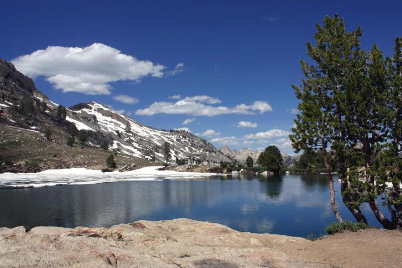
A clear blue alpine lake in the foreground, with snow-capped rocky mountains and evergreen trees in the background under a sunny blue sky.
Lamoille Lake, set against the snow-dusted peaks of the Ruby Mountains in Humboldt-Toiyabe National Forest.

Humboldt, Toiyabe National Forest history and protected-area timeline

The lands now encompassed by Humboldt–Toiyabe National Forest have been reorganized multiple times across more than a century of federal forest administration. The forest's earliest ancestor is the Ruby Mountains National Forest, established on May 3, 1906, by President Theodore Roosevelt. Just two years later, in 1908, that reserve was combined with the Independence National Forest to form the Humboldt National Forest.

The Toiyabe National Forest was established a year before Humboldt, on March 2, 1907, but ceased to exist as an independent unit in 1932, when it was absorbed into the Nevada National Forest. It was reestablished in 1938 from parts of the Humboldt and Nevada forest reserves, reflecting the fluid administrative boundaries that characterized early 20th-century national forest management.

A major reorganization occurred on October 1, 1957, during President Dwight D. Eisenhower's administration, when the older Nevada National Forest was dissolved and its lands redistributed between the Humboldt and Toiyabe reserves. For nearly four more decades, the two forests continued to operate as separate units. Finally, in 1995, under President Bill Clinton, the Humboldt and Toiyabe National Forests were administratively combined, although they remain legally and geographically distinct entities to this day.

Humboldt, Toiyabe National Forest landscape and geographic character

Humboldt–Toiyabe National Forest is a landscape defined by Nevada's basin-and-range geography: long, narrow mountain ranges separated by broad desert valleys, with each mountain block holding its own isolated ecosystem of forests, streams, and wildlife. The forest sprawls across most of the state, with notable concentrations in the Santa Rosa Range, the Ruby Mountains, the East Humboldt Range, the Jarbidge Mountains, the Schell Creek Range, the Toiyabe Range, the Toquima Range, the Monitor Range, the Hot Creek Range, and the Spring Mountains.

The Ruby Mountains are among the most visually striking parts of the forest, sculpted by glacial activity into deep U-shaped canyons such as Lamoille Canyon, with alpine lakes like Lamoille Lake set among glacially carved basins. The Spring Mountains, by contrast, rise abruptly from the Mojave Desert near Las Vegas and contain some of the highest elevations in the forest, including Mount Charleston.

Across the state line, the forest's California portions in Mono, Alpine, Sierra, Nevada, Lassen, and El Dorado counties include portions of the Sierra Nevada's eastern flank, with landscapes that transition between Great Basin desert and high Sierra terrain. The result is an unusually diverse and discontinuous national forest that reads, on a map, like a constellation of public lands scattered across two states.
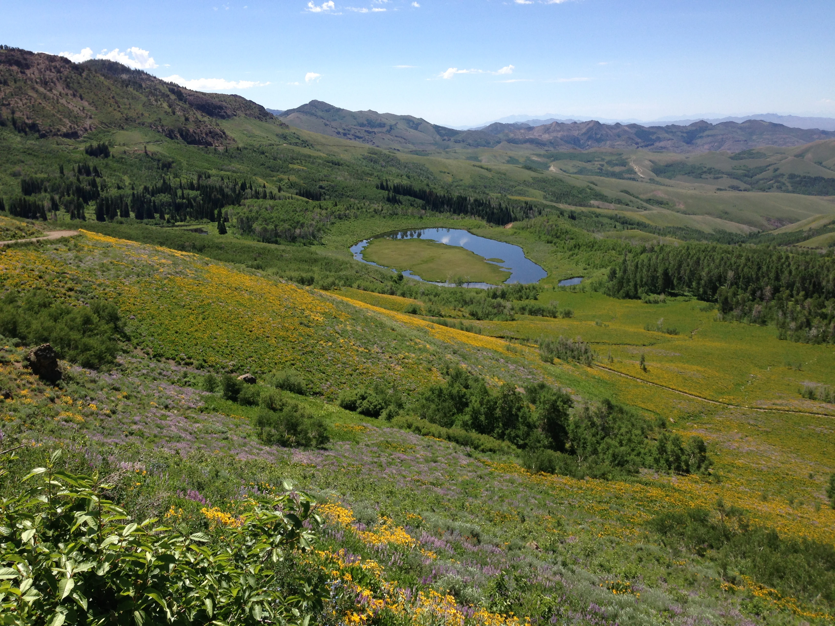
A wide, high-angle landscape shot looking down over a lush, green mountain valley in Copper Basin, featuring a small, oval-shaped pond in the center surrounded by meadows, scattered trees, and hills covered in patches of yellow and purple wildflowers.
A view overlooking the verdant, wildflower-strewn slopes of Copper Basin in the Humboldt-Toiyabe National Forest.

Humboldt, Toiyabe National Forest ecosystems, habitats, and plant life

Ecologically, Humboldt–Toiyabe spans an extraordinary range of habitats, from low-elevation piñon-juniper woodlands and sagebrush steppe to high-elevation subalpine forests, alpine meadows, and even ancient bristlecone pine stands. Because the forest is dispersed across so many mountain ranges, each block carries its own local ecosystem, with streams, springs, and aspen groves clustered into the higher elevations.

The Ruby Mountains and East Humboldt Range are notable for their lush, green appearance relative to the surrounding deserts, sustained by reliable mountain precipitation. These ranges support dense conifer forests, including whitebark pine, limber pine, and Engelmann spruce at higher elevations, while aspen groves thrive in many of the canyons. Mountain meadows burst with wildflowers during summer, particularly in areas like Copper Basin in the Jarbidge and Mountain City ranger districts.

The Spring Mountains harbor one of the most diverse alpine ecology zones in the Great Basin, with isolated sky-island forests and remarkable botanical endemism, including ancient bristlecone pines that are among the oldest living trees in the world.
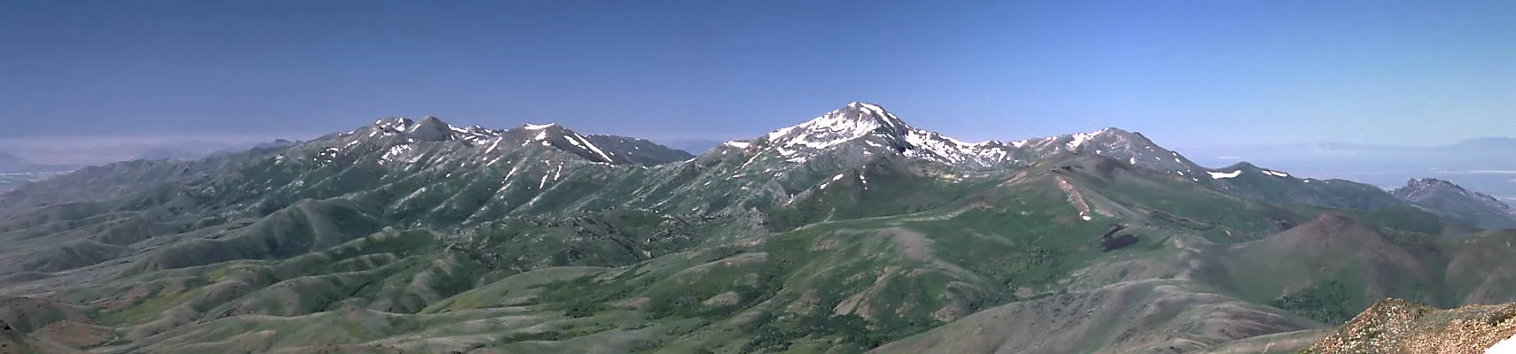
A wide panoramic view of a mountain range with patches of snow on the peaks, grassy slopes, and a clear blue sky.
A panoramic view of the Santa Rosa Mountains within the Humboldt-Toiyabe National Forest.

Humboldt, Toiyabe National Forest wildlife and species highlights

The varied habitats of Humboldt–Toiyabe National Forest support a correspondingly rich array of wildlife. Big game species such as mule deer, elk, pronghorn, and bighorn sheep thrive across the forest's mountain ranges, with the Ruby Mountains and East Humboldt Range being especially well known for their elk populations and bighorn sheep herds.

Predators including mountain lions, black bears, and coyotes are present throughout much of the forest, and the forest's wilderness areas, such as Jarbidge, Ruby Mountains, and East Humboldt Wilderness, provide secure habitat for these species. The forest's rivers, lakes, and high meadows are home to trout, including native and introduced populations in alpine lakes like Lamoille Lake, while avian life spans raptors like golden eagles and great horned owls, sagebrush-dependent species, and numerous migratory songbirds that pass through the higher elevations during seasonal movements.
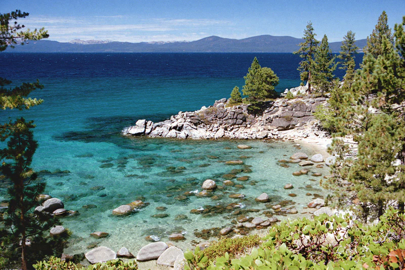
A high-angle view of a small, rocky cove with clear, turquoise water, surrounded by pine trees and large boulders, with a large, deep blue lake and distant mountains in the background.
The clear turquoise waters of Secret Cove along the shoreline of Lake Tahoe.

Humboldt, Toiyabe National Forest conservation status and protection priorities

Humboldt–Toiyabe plays a central conservation role across the Great Basin, protecting the headwaters, forests, and alpine ecosystems that sustain much of Nevada's wildlife and water systems. With its large number of designated wilderness areas, including Ruby Mountains, Jarbidge, East Humboldt, Alta Toquima, Arc Dome, Mount Charleston, and others, the forest safeguards some of the most intact wild landscapes in the lower 48 states.

These wilderness areas protect high-elevation watersheds, old-growth stands, and habitat connectivity that is increasingly important as surrounding arid lands face pressure from development, wildfire, and invasive species. The Spring Mountains in particular harbor globally significant botanical resources, including some of the oldest trees on Earth, while the Ruby Mountains and Jarbidge ranges represent anchor ecosystems for native trout, bighorn sheep, and other sensitive species.

Humboldt, Toiyabe National Forest cultural meaning and human context

The forest carries deep cultural and historical roots tied to both Indigenous heritage and early American conservation history. The name Toiyabe is a Native American word, reflecting the original inhabitants of central Nevada's mountain ranges. Numerous place names, trails, and cultural sites throughout the forest reflect the long Indigenous presence in these landscapes, including Shoshone, Paiute, and other Great Basin peoples.

The forest also embodies a chapter of American conservation history: the establishment of the original Ruby Mountains National Forest by President Theodore Roosevelt in 1906 placed the region among the early national forest reserves of the American conservation movement. The forest's repeated reorganizations, from the early 20th century through 1957 and the 1995 administrative merger, illustrate how federal land management in the West evolved over time.
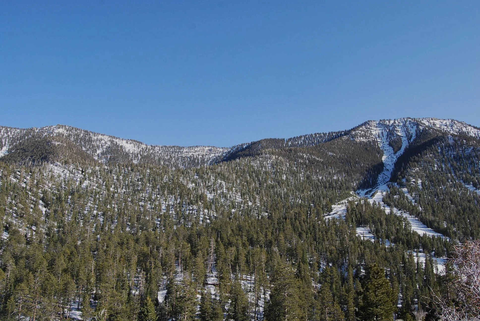
A wide shot of a mountainside covered in dense green coniferous forest with patches of snow on the ground and steep terrain under a clear blue sky.
Snow-covered coniferous forest slopes within the Spring Mountains of the Humboldt-Toiyabe National Forest.

Top sights and standout views in Humboldt, Toiyabe National Forest

Among Humboldt–Toiyabe's most distinctive features are the glacially carved Lamoille Canyon and the alpine lakes of the Ruby Mountains; the remote, rugged Jarbidge Wilderness; the botanical richness and sky-island forests of the Spring Mountains near Las Vegas; and the unusual geographic pattern of forest land scattered across dozens of Nevada mountain ranges and reaching into the eastern Sierra.

The forest's sheer scale, more than 6.3 million acres across two states, combined with its long list of designated wilderness areas, makes it one of the most ecologically significant and visually diverse national forests in the contiguous United States.

Best time to visit Humboldt, Toiyabe National Forest

Summer and early autumn are typically the most rewarding seasons for experiencing Humboldt–Toiyabe National Forest, when high-elevation roads such as the Lamoille Canyon Scenic Byway open fully, alpine wildflower displays peak in meadows and basins like Copper Basin, and temperatures in the higher ranges become comfortable for hiking and camping. Winter brings its own appeal to parts of the forest, particularly the Spring Mountains near Las Vegas, where Mount Charleston offers snow-based recreation in a striking desert-adjacent setting. Spring can be short and unpredictable across the Great Basin, while late autumn often provides crisp weather and reduced crowds in many ranger districts.
Monthly climate preview

Long-term representative point measurements tracking monthly temperature and precipitation rhythm

Humboldt Toiyabe National Forest Climate Normals and Annual Temperature Patterns

Historical climate records for Humboldt Toiyabe National Forest outline a measured annual progression of shifting daily temperatures and precipitation rates from a representative coordinate. Accessing the complete twelve-month profile provides deeper analytical context for long-term regional weather variations.
Annual mean9 °C
-2 °C22 °C
Jan-2°
Feb
Mar
Apr
May11°
Jun17°
Jul22°
Aug21°
Sep16°
Oct
Nov
Dec-2°
Warmest month
July

22.5 °C

Coolest month
December

-2.3 °C

Wettest month
May

1.1 mm/day

Driest month
August

0.4 mm/day

Park location guide

Geography guide, regional context, and park location map for Humboldt, Toiyabe National Forest

Humboldt, Toiyabe National Forest park geography, regions, and map view in United States of America

Understand where Humboldt, Toiyabe National Forest sits in United States of America through a broader geographic reading of the surrounding landscape, nearby location context, and its mapped position within the national park landscape.

How Humboldt, Toiyabe National Forest fits into United States of America

The United States of America is a federal presidential republic and one of the world's largest countries by area and population. It consists of 50 states across a vast territory spanning multiple time zones, with its capital in Washington, D.C. and largest city in New York City. The nation has a diverse economy, influential political system, and significant cultural and military presence globally.

Wider geography shaping Humboldt, Toiyabe National Forest in United States of America

The United States occupies a vast territory in North America, bordered by Canada to the north and Mexico to the south. The 48 contiguous states stretch from the Atlantic to the Pacific Ocean, while Alaska occupies the northwestern region and Hawaii is an archipelago in the Pacific. The country encompasses diverse terrain including the Rocky Mountains, Appalachian Mountains, Great Plains, and extensive river systems.

Map view of Humboldt, Toiyabe National Forest

Use this park location map to pinpoint Humboldt, Toiyabe National Forest in United States of America, understand its exact geographic position, and read its mapped placement within the surrounding landscape more clearly.

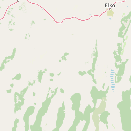
Pigeon | © OpenStreetMap contributors

Location context for Humboldt, Toiyabe National Forest

CaliforniaNevada
Recorded earthquake history

Explore Historical Earthquake Records for Humboldt–Toiyabe National Forest

Review the recorded seismic history associated with the mountain ranges of Humboldt–Toiyabe National Forest. This MoriAtlas catalogue provides a searchable interface for historical epicentre data, event magnitudes, and depths for researchers and geography enthusiasts tracking the region's long-term seismic patterns.

Humboldt–Toiyabe Earthquake History

Catalogued events

3,636 events

Strongest magnitude

Magnitude 6.1

Most recent event

Aug 19, 2026

This history includes earthquakes recorded inside the park or within 50 km of its borders

Visual reference for basin-and-range topography, alpine wilderness, and high desert terrain.

Humboldt–Toiyabe National Forest Photos and Landscape Scenery

Examine curated photography of Humboldt–Toiyabe National Forest to observe glacial canyons, isolated mountain ranges, and subalpine habitats. Visual records reveal the complex topography and protected ecosystems spanning across Nevada and eastern California.

A clear blue alpine lake in the foreground, with snow-capped rocky mountains and evergreen trees in the background under a sunny blue sky.

A winding asphalt road with double yellow lines travels through a steep mountain canyon; rocky hillsides are on the left and a lush green valley with mountain peaks is in the background.

A wide, high-angle landscape shot looking down over a lush, green mountain valley in Copper Basin, featuring a small, oval-shaped pond in the center surrounded by meadows, scattered trees, and hills covered in patches of yellow and purple wildflowers.

A wide panoramic view of a mountain range with patches of snow on the peaks, grassy slopes, and a clear blue sky.

A high-angle view of a small, rocky cove with clear, turquoise water, surrounded by pine trees and large boulders, with a large, deep blue lake and distant mountains in the background.

A wide, eye-level shot of a sprawling meadow filled with purple lupine and yellow sunflowers in the foreground, with rolling green hills and mountains under a cloudy blue sky in the background.

A wide shot of a mountainside covered in dense green coniferous forest with patches of snow on the ground and steep terrain under a clear blue sky.

Park atlas

Compare surrounding regional geography and connected wilderness areas across the American West

Parks Near Humboldt–Toiyabe National Forest and Related Protected Landscapes

Browsing other protected areas near Humboldt–Toiyabe National Forest reveals broader regional patterns across the Great Basin and the eastern Sierra Nevada. Comparing neighboring mountain ranges and high desert reserves expands geographic context for public lands throughout the region.
Watercolor painting of a tranquil mountain lake surrounded by pine forests and distant rolling peaks in muted green and pink tones.
Wildlife reserveTuolumne County
Park boundaries overlap#1 closest

Southwest

Emigrant Wilderness: A Detailed Geographic Atlas of Protected Sierra Nevada Landscapes

Mapping glaciated granite basins and volcanic ridges in Tuolumne County.

Emigrant Wilderness is a sprawling protected area defined by a distinct mix of granitic domes, cirques, and a unique volcanic sector in its northeastern reaches. Spanning from lower forest elevations to alpine peaks, the area provides a window into the complex geological history of the central Sierra Nevada. The terrain includes hundreds of high-country lakes and meadow systems that support diverse alpine ecosystems and represent the rugged nature of the Pacific Crest Trail corridor.

Area
454.37 km²
Established
1974
IUCN
Ib
Relief
Mountain
Wildlife reserveCalifornia
Park boundaries overlap#2 closest

Southwest

Hoover Wilderness: Protected Alpine Geography in the Central Sierra Nevada, California

High-altitude glacial basins and Sierra crest wilderness

The Hoover Wilderness preserves a vital strip of high-elevation terrain along the eastern Sierra Nevada crest. Characterized by glacier-carved basins, interconnected alpine lakes, and sharp granite ridges, this protected area serves as a primary ecological gateway to the high country. Its landscape features define the headwaters of the Walker River, offering a compact yet significant look at California's protected alpine wilderness.

Area
518.89 km²
Established
1964
IUCN
Ib
Relief
Mountain
A horizontal watercolor painting depicting a mountain range in the background with rolling hills and a winding river or stream in the foreground.
Protected landscapeCalifornia
Park boundaries overlap#3 closest

Southwest

Inyo National Forest: An Atlas of Protected Landscapes and Sierra Nevada Geography

High altitude wilderness and volcanic terrain in Eastern California

Spanning from the arid Owens Valley floor to the 14,000 foot crest of the Sierra Nevada, Inyo National Forest remains a cornerstone of the American West. This protected landscape contains the Ancient Bristlecone Pine Forest, Mount Whitney, and the Mono Inyo volcanic chain, providing a dense geographic record of glacial, tectonic, and ecological diversity across a vast managed corridor.

Area
7,702.71 km²
Established
1907
IUCN
Ib
Relief
Mountain
Wildlife reserveNevada
Park boundaries overlap#4 closest

Northeast

Jarbidge Wilderness: Protected Mountain Terrain and Geographic Map Context in Nevada

High-altitude wilderness geography and canyon landscapes

Located in the remote Jarbidge Mountains, this wilderness area transitions from arid sagebrush steppe to dense subalpine forests and dramatic river canyons. The region preserves headwater streams and over a dozen significant summits, offering a complex look at the natural topography of the northern Great Basin in Nevada.

Area
457.97 km²
Established
1964
IUCN
Ib
Relief
Mountain
Watercolor painting showing stylized green mountains, pine trees, and soft yellow and purple tones in the landscape.
Wildlife reserveNevada
Park boundaries overlap#5 closest

South

Mount Charleston Wilderness: Protected Mountain Geography and Spring Mountains Atlas

High-altitude wilderness and ancient forest landscapes in southern Nevada

Spanning the crest of the Spring Mountains, Mount Charleston Wilderness stands as a protected natural landmark in Nevada. This area offers an atlas-focused view of subalpine ridges, ancient bristlecone pine forests, and steep fault-block terrain that contrast significantly with the arid Mojave Desert basins located below.

Area
232.46 km²
Established
1989
IUCN
Ib
Relief
Mountain
Protected areaNevada
Mapped location lies within the park boundary#6 closest

East

Mount Moriah Wilderness: A Geographic Profile of the Northern Snake Range Protected Area

High elevation limestone terrain in eastern Nevada

The Mount Moriah Wilderness represents a significant protected area in eastern Nevada, anchored by the iconic 12,050-foot Mount Moriah and the expansive flat-topped Table plateau. This rugged high-country landscape displays deep limestone exposures, shallow caves, and a rich array of riparian habitats. Spanning an entire elevational gradient of the Great Basin, the wilderness preserves ancient bristlecone pine groves alongside critical archaeological sites that document long-term human use of these mountains.

Area
363.4 km²
Established
1989
Relief
Mountain
Water
Minor water
Protected areaNevada
Mapped location lies within the park boundary#7 closest

West

Mount Rose Wilderness: Protected Landscape and Regional Geography in Northwestern Nevada

Carson Range alpine terrain and ecological transition mapping

Mount Rose Wilderness represents a significant protected area in the Carson Range, where 31,223 acres of terrain transition from the forested, subalpine slopes of the Sierra Nevada to the drier, sage-dominated Great Basin. The mapped landscape includes high granite peaks and meadows, offering a clear view of the complex environmental gradients that define this unique section of the American West.

Area
126.35 km²
Established
1989
Relief
Mountain
Climate
Temperate
Wildlife reserveNye County
Park boundaries overlap#8 closest

Southeast

Quinn Canyon Wilderness: Exploring Protected Mountain Geography in Central Nevada

High-desert ridges and alpine canyon ecosystems

Quinn Canyon Wilderness serves as a vital protected area for understanding Great Basin geography. Its landscape of deep, V-shaped canyons and high ridgelines supports unique biological gradients from pinyon-juniper forests to rare bristlecone pine, providing a study in extreme solitude and rugged mountain terrain.

Area
106.25 km²
Established
1989
IUCN
Ib
Relief
Mountain

Common questions about visiting, size, designation, and location context for Humboldt, Toiyabe National Forest

Humboldt, Toiyabe National Forest FAQs for park facts, access, geography, and protected area context

Find quick answers about Humboldt, Toiyabe National Forest, including protected-area facts, park geography, trail and visitor context, and how the park fits into its surrounding country and regional landscape.
MoriAtlas Explorer

Continue Your Protected Areas Search Across the Global Atlas

Deepen your exploration by continuing the structured search for national parks and protected areas worldwide. Utilize the comprehensive filtering capabilities to compare different conservation landscapes and refine your understanding of global park geography. Discover more about the distribution and characteristics of protected natural areas.

Global natural geography