

Mori Atlas logo
Marine protected areaHuon Commonwealth Marine Reserve

Discover the complex topography and marine ecosystems defining this offshore conservation area.

Huon Commonwealth Marine Reserve: Mapping Deep Ocean Seamounts and Tasmanian Protected Landscapes

The Huon Commonwealth Marine Reserve protects an extensive offshore environment south of Tasmania, encompassing nearly ten thousand square kilometers of deep ocean. Centered on a concentration of approximately seventy submerged seamounts, this reserve provides essential habitat and vertical relief within the South-east Commonwealth Marine Reserve Network. These geological structures rise hundreds of meters above the seafloor, creating vital foraging and spawning grounds that distinguish this protected marine landscape.

marine protected areaseamountsdeep ocean habitatsubmerged volcanic landscapeTasmanian watersPacific Ocean

Huon Commonwealth Marine Reserve

Marine protected area

Park overview

Structured park overview, official facts, and landscape profile for Huon Commonwealth Marine Reserve

Huon Commonwealth Marine Reserve park facts, protected area profile, and essential visitor context

Review the core facts for Huon Commonwealth Marine Reserve, including designation, size, terrain, visitor scale, habitats, and operating context in one park-focused overview.

About Huon Commonwealth Marine Reserve

Huon Commonwealth Marine Reserve lies in the deep Pacific waters south of Tasmania, on the southeastern edge of the Australian continental margin. Covering 9,991 square kilometers of Commonwealth waters, it represents one of the more distinctive offshore components of Australia's national marine reserve system, focused not on coastal scenery but on a largely submerged landscape of volcanic seamounts and their associated deep-sea ecosystems. The reserve's nearest onshore reference point is Cockle Creek in southern Tasmania, reflecting the considerable distance between the protected area and the Tasmanian mainland.

The defining feature of the reserve is a chain of approximately seventy seamounts, cone-shaped mountains rising from the seafloor to elevations of about 750 meters at some peaks to as much as 1,700 meters at others. These structures interrupt the otherwise uniform deep seafloor, generating steep depth gradients, currents, upwelling zones, and hard volcanic substrates that together support an unusual concentration of marine biodiversity for such a remote offshore location. The seamounts form the backbone of the reserve's ecological identity and are central to its conservation value.

Huon is recognized as an important foraging ground for great white sharks and for seabirds that feed over the productive waters above the seamount chain. The same areas also function as spawning and nursery habitat for commercial fish species such as ocean perch and blue warehou, highlighting the reserve's role in both conservation and sustainable fisheries management. The protected area was created from the earlier Tasmanian Seamounts Marine Reserve of 1999, which was incorporated into the larger Huon reserve in 2007 as part of the broader South-east Commonwealth Marine Reserves planning process.

Managed by Parks Australia, the reserve is operated through a zoning system that combines a dominant Multiple Use zone with a smaller Habitat Protection zone focused on the seamounts. This design reflects an effort to balance long-term habitat and biodiversity protection with regulated human uses, allowing carefully controlled activities while shielding the most sensitive benthic communities from significant disturbance.

Quick facts and research context for Huon Commonwealth Marine Reserve

Huon Commonwealth Marine Reserve is an Australian Commonwealth marine reserve located in the Pacific Ocean south of Tasmania, with its nearest mainland reference point at Cockle Creek. Established in its current form in 2007 and incorporating the earlier 1999 Tasmanian Seamounts Marine Reserve, it spans about 9,991 square kilometers of deep offshore waters governed by Parks Australia on behalf of the Commonwealth of Australia. The reserve is zoned primarily as Multiple Use under IUCN category VI, with a smaller Habitat Protection zone in the west that safeguards the benthic communities on the seamounts.

Protection and recognition

Examine the documented marine protection scope and official designation records.

Huon Commonwealth Marine Reserve Protection Status and Governance Data

Huon Commonwealth Marine Reserve maintains a documented marine protection scope governed by federal management frameworks. Structured records outline the established conservation boundaries and associated administrative status.

Protection details

Protection scope
Marine
Transboundary protection
No
Park context

Deeper park guide and search-rich context for Huon Commonwealth Marine Reserve

Huon Commonwealth Marine Reserve history, landscape, wildlife, and travel context

Explore Huon Commonwealth Marine Reserve through its history, landscape character, ecosystems, wildlife, conservation priorities, cultural context, and seasonal travel timing in a structured park guide built for atlas discovery and search intent.

Why Huon Commonwealth Marine Reserve stands out

The Huon reserve is defined above all by its cluster of approximately seventy seamounts, isolated submarine peaks that rise between roughly 750 and 1,700 meters above the seafloor. These seamounts create varied depth zones and hard-substrate habitats that concentrate marine life on an otherwise relatively uniform deep seafloor. The reserve is also known as a biologically productive offshore area that supports large predatory fish, seabirds, and important commercial fisheries during their early life stages. Combined, these qualities make Huon one of the key deepwater conservation sites in the South-east Commonwealth Marine Reserve Network.

Huon Commonwealth Marine Reserve history and protected-area timeline

The Huon reserve's origins lie in the Tasmanian Seamounts Marine Reserve, which was established on 12 May 1999 to protect the cluster of seamounts in waters south of Tasmania. That original reserve focused on the benthic communities of the submerged mountains and represented an early effort to recognize deep-sea geological features as legitimate objects of marine conservation in Commonwealth waters.

In 2007, the Tasmanian Seamounts Marine Reserve was incorporated into a much larger Huon Commonwealth Marine Reserve, expanded and reconfigured as part of Australia's broader development of the South-east Commonwealth Marine Reserve Network. The redesign brought the seamount habitats into a wider offshore management framework, embedding their protection within a regional network that connects multiple deepwater reserves along southeastern Australia. Since then, the reserve has continued to be managed by Parks Australia as part of this regional marine conservation system.

Huon Commonwealth Marine Reserve landscape and geographic character

The landscape of the Huon reserve is almost entirely underwater, defined by the topography of the deep ocean floor south of Tasmania. Rather than terrestrial peaks, the reserve's signature landforms are seamounts: cone-shaped geological structures rising from the abyssal depths to elevations of between roughly 750 meters and 1,700 meters above the surrounding seafloor. With approximately seventy such peaks within its boundaries, the reserve holds one of the more notable concentrations of submarine mountains in the southeast Australian region.

These seamounts create dramatic vertical relief in an otherwise flat marine environment, with steep flanks, ridgelines, summits, and craters that support distinct depth-related habitats. The varied topography influences local currents and water movement above the peaks, contributing to upwelling conditions and aggregations of marine life that distinguish the area from the surrounding deep ocean plain.

Huon Commonwealth Marine Reserve ecosystems, habitats, and plant life

The ecological character of the Huon reserve is shaped by the unusual combination of deep ocean habitat and the topographic complexity introduced by its seamounts. Hard volcanic substrates, varying depths, and altered current regimes around the peaks create conditions that support a richer and more diverse assemblage of marine life than is typical for the surrounding abyssal seafloor. The seamount communities include benthic organisms adapted to elevated, current-swept rocky environments, while the surrounding waters host a broader deep-sea ecosystem.

Beyond the benthic zone, the reserve supports open-water and pelagic systems that connect the seamount chain with wider Tasmanian and Pacific Ocean ecosystems. The result is a layered habitat mosaic that links seafloor communities, mid-water species, and surface-dwelling seabirds, giving the reserve an ecological profile that extends from the abyssal depths to the wave- and wind-swept ocean surface above.

Huon Commonwealth Marine Reserve wildlife and species highlights

The Huon Commonwealth Marine Reserve supports a mix of large predatory species, seabirds, and commercially important fish, all of which benefit from the productive conditions generated by the seamount chain. Great white sharks use the area as a foraging ground, drawn by the concentrations of prey that aggregate around the underwater peaks.

Seabirds also rely on the reserve, feeding over the productive waters above the seamounts. The reserve additionally serves as spawning and nursery habitat for species of commercial fisheries importance, including ocean perch and blue warehou, making it a significant area for both natural ecosystem functioning and fisheries sustainability. While much of the local biodiversity sits below the surface in deep-water and benthic communities, the reserve's wildlife importance rests on the way these different animal groups converge around the seamount topography.

Huon Commonwealth Marine Reserve conservation status and protection priorities

From a conservation standpoint, Huon is significant because it protects one of the most notable seamount clusters in southeastern Australian waters, including benthic communities that grow on otherwise rare hard substrates in a region otherwise dominated by soft sediments. The reserve's Habitat Protection zone, covering 389 square kilometers in the western part of the area, is specifically designated to shield these vulnerable benthic communities from activities that could damage them.

The larger Multiple Use zone, classified under IUCN category VI and accounting for the bulk of the reserve's 9,602 square kilometers, allows certain activities such as commercial fishing with approval, recognizing both the conservation value and the regional economic importance of the surrounding waters. The reserve's economic values are balanced with its ecological values at the same time as these measures collectively place Huon within the South-east Commonwealth Marine Reserves Network, contributing to a regional-scale approach to protecting deepwater ecosystems off Australia's southern coast.

Top sights and standout views in Huon Commonwealth Marine Reserve

A defining highlight of the Huon Commonwealth Marine Reserve is its cluster of approximately seventy seamounts, cone-shaped submerged mountains that provide rare structural complexity in deep Tasmanian waters. These geological features concentrate marine life, serve as foraging grounds for great white sharks and seabirds, and act as spawning and nursery habitat for commercially important fish species such as ocean perch and blue warehou.

Equally notable is the reserve's dual-zone management approach, in which a small but ecologically critical Habitat Protection zone safeguards the most sensitive benthic communities while a much larger Multiple Use zone accommodates regulated activities elsewhere in the reserve. Together, these qualities make Huon a key offshore component of Australia's South-east Commonwealth Marine Reserve Network and an important site for both biodiversity protection and sustainable marine resource use.

Best time to visit Huon Commonwealth Marine Reserve

As a deep offshore marine reserve, Huon Commonwealth Marine Reserve does not offer conventional shore-based visiting seasons; conditions on the surrounding Tasmanian ocean are strongly shaped by weather and wave patterns year-round. Visitation or research activity tends to be most feasible during the calmer summer months around southern Australia, when sea conditions south of Tasmania are typically more workable, though the protected area itself remains largely a managed offshore zone rather than a typical destination for casual visitors.
Monthly climate preview

Long term monthly temperature and precipitation averages for Tasmania marine geography

Huon Commonwealth Marine Reserve Climate Normals and Annual Temperature Rhythm

Representative coordinate measurements track average monthly temperatures between 10.47 degrees and 18.18 degrees Celsius alongside consistent year round precipitation patterns. Examining the complete twelve month profile provides deeper insight into measured long term climate variations across the marine protected area.
Annual mean12 °C
10 °C14 °C
Jan14°
Feb14°
Mar14°
Apr13°
May12°
Jun11°
Jul11°
Aug10°
Sep11°
Oct11°
Nov12°
Dec13°
Warmest month
February

14.3 °C

Coolest month
August

10.5 °C

Wettest month
August

4.2 mm/day

Driest month
January

2.4 mm/day

Park location guide

Geography guide, regional context, and park location map for Huon Commonwealth Marine Reserve

Huon Commonwealth Marine Reserve park geography, regions, and map view in Australia

Understand where Huon Commonwealth Marine Reserve sits in Australia through a broader geographic reading of the surrounding landscape, nearby location context, and its mapped position within the national park landscape.

How Huon Commonwealth Marine Reserve fits into Australia

Australia is a constitutional monarchy and federal parliamentary democracy comprising six states and ten territories. With a population of nearly 28 million, it is one of the world's most urbanised countries, with most people concentrated on the eastern seaboard. The country has a high Human Development Index and is known for its cultural diversity, ancient Aboriginal heritage, and unique wildlife.

Wider geography shaping Huon Commonwealth Marine Reserve in Australia

Australia occupies the entire Australian continent, the island of Tasmania, and numerous smaller islands. It is the world's flattest and driest inhabited continent, featuring vast deserts in the interior (the Outback), tropical rainforests along the eastern coast, and a coastline bordering the Indian and Pacific Oceans.

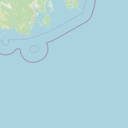
Map view of Huon Commonwealth Marine Reserve

Use this park location map to pinpoint Huon Commonwealth Marine Reserve in Australia, understand its exact geographic position, and read its mapped placement within the surrounding landscape more clearly.

Pigeon | © OpenStreetMap contributors

Location context for Huon Commonwealth Marine Reserve

Tasmania
Park atlas

Compare adjacent marine environments and regional protected conservation areas

Explore Parks Near Huon Commonwealth Marine Reserve and Surrounding Waters

Browse other protected areas near Huon Commonwealth Marine Reserve to examine connected deep ocean habitats and regional marine networks. Regional park comparisons reveal wider ecological patterns across southeastern Tasmanian waters and offshore protected landscapes.
National parkTasmania
5.5 km away#1 closest

Northwest

Southwest National Park: Tasmania's Core Wilderness National Park and World Heritage Landscape

Mapping the remote buttongrass moorlands and rugged terrain of this expansive park.

Southwest National Park represents a significant protected area in Tasmania, Australia, spanning over 6,183 square kilometers. As the heart of the Tasmanian Wilderness World Heritage Area, it showcases an extraordinary landscape characterized by vast buttongrass moorlands, ancient temperate rainforests, and dramatic mountainous terrain. This park is vital for its wilderness character and conservation significance, offering a unique opportunity to explore one of the Southern Hemisphere's last remaining untouched temperate wildernesses through its mapped geography and protected boundaries.

Area
6,182.67 km²
Established
1968
IUCN
II
Relief
Mountain
National parkTasmania
9.5 km away#2 closest

Northwest

South Bruny National Park: Tasmania's Protected Area Geography and Mapped Landscape Context

Discover the geographic identity and mapped boundaries of this Tasmanian National Park.

South Bruny National Park is a key protected landscape located in Tasmania, Australia, offering critical insights into regional conservation efforts. As a designated National Park, its identity is tied to the preservation of its unique geographic features and natural terrain. This entry provides detailed information on its mapped boundaries and its place within Tasmania's broader atlas of protected areas, facilitating a deeper understanding of its protected landscape significance.

Area
50.59 km²
Established
1997
IUCN
II
Visitors
9.2K annual
Marine protected areaTasmania
27 km away#3 closest

West

Tasman Fracture Commonwealth Marine Reserve: Mapping Deep Ocean Protected Landscapes

Offshore Tasmania marine habitat and seafloor geography overview.

Spanning over 42,500 square kilometres of deep ocean, the Tasman Fracture Commonwealth Marine Reserve protects diverse marine life and complex bathymetry off the south-west coast of Tasmania. Discover the geological significance of the Tasman Fracture itself and how the reserve supports deepwater hard corals, seabirds, and marine mammals within a transitional oceanic zone influenced by the Zeehan Current.

Area
42,502 km²
Established
2007
IUCN
VI
Access
Remote access
National parkTasmania
43 km away#4 closest

Northwest

Hartz Mountains National Park: Tasmania's National Park Protected Landscape

Mapped geography and regional landscape context.

Delve into the specific protected landscape identity of Hartz Mountains National Park, situated in Tasmania, Australia. This page provides a detailed geographic breakdown, focusing on mapped park boundaries and its unique regional setting. Understand the atlas value of this national park by exploring its terrain and its role within Tasmania's broader conservation landscape.

Area
71.4 km²
Established
1939
IUCN
II
Visitors
11.8K annual
National parkTasmania
61 km away#5 closest

North

Tasman National Park: Discover Its National Park Geography and Protected Landscape

Explore mapped boundaries and regional context within Tasmania.

Tasman National Park represents a key protected area for exploration within Tasmania's distinctive geography. This page facilitates a detailed look at its national park identity, focusing on its mapped natural landscapes and its contribution to the protected area network of the Australian island state. Gain structured geographic insight into this significant conservation landscape.

Area
107.5 km²
Established
1999
IUCN
II
Relief
Mixed relief
Marine protected areaTasmania
89 km away#6 closest

Southeast

South Tasman Rise Commonwealth Marine Reserve Marine Protected Area and Geological Atlas

Deep-sea submarine landscapes and Australian offshore geography.

The South Tasman Rise Commonwealth Marine Reserve represents a vital offshore protected area, defined by its remote location and significant deep-sea geological features. Users can examine the reserve's unique bathymetry, including the distinctive truncated peaks of submerged seamounts and broad submarine plateaus that characterize this southern marine frontier far beyond the continental shelf.

Area
27,704 km²
Established
2007
IUCN
VI
Climate
Subpolar
National parkTasmania
108 km away#7 closest

Northwest

Mount Field National Park: Explore Tasmania's Protected Landscape and Geographic Identity

Mapped terrain and regional atlas context for this Australian national park.

Mount Field National Park serves as a cornerstone of protected natural landscapes in Tasmania, Australia. This entry provides detailed geographic context, focusing on its mapped boundaries and distinct environmental setting. Users can explore its identity as a national park, understand its regional placement within Tasmania, and gain insight into the mapped terrain that defines this significant protected area. It is designed for atlas-based discovery of the park's landscape characteristics.

Area
162.65 km²
Established
1916
IUCN
II
Relief
Mountain
National parkAustralia
115 km away#8 closest

North

Maria Island National Park: Australian Protected Landscape and Geographic Discovery

Explore its mapped terrain and regional natural context.

Maria Island National Park represents a key protected landscape within Australia, offering dedicated content for geographic exploration. As a national park, it provides specific insights into its mapped boundaries, natural terrain, and overall landscape character. Users can delve into the geographic context of this protected area, understanding its unique position within Australia's atlas of significant natural spaces and conservation lands, fostering detailed discovery.

Common questions about visiting, size, designation, and location context for Huon Commonwealth Marine Reserve

Huon Commonwealth Marine Reserve FAQs for park facts, access, geography, and protected area context

Find quick answers about Huon Commonwealth Marine Reserve, including protected-area facts, park geography, trail and visitor context, and how the park fits into its surrounding country and regional landscape.
MoriAtlas Explorer

Continue Your Protected Areas Search Across the Global Atlas

Deepen your exploration by continuing the structured search for national parks and protected areas worldwide. Utilize the comprehensive filtering capabilities to compare different conservation landscapes and refine your understanding of global park geography. Discover more about the distribution and characteristics of protected natural areas.

Global natural geography