Mori Atlas logo
National parkHustai National Park

Analyzing the geographic transition from riverine woodland to open grassland terrain

Hustai National Park: Mapping the Protected Landscapes and Mountain Steppe of Töv Province

Hustai National Park preserves an essential mosaic of mountain forest and steppe habitats within Mongolia. Situated in Töv Province, this protected area features a diverse topography where the Khustai range ridges descend into the expansive grasslands of the Mongolian plateau. The Tuul River corridor provides a critical riparian environment, supporting a complex distribution of wild fauna and flora across varying elevations and aspects.

steppeforest-steppemountain-steppePrzewalski's horsewild horse reintroductionImportant Bird Area

Hustai National Park

National park

Park overview

Structured park overview, official facts, and landscape profile for Hustai National Park

Hustai National Park park facts, protected area profile, and essential visitor context

Review the core facts for Hustai National Park, including designation, size, terrain, visitor scale, habitats, and operating context in one park-focused overview.

About Hustai National Park

Hustai National Park, sometimes called Khustain Nuruu National Park, occupies a strategic position in central Mongolia where the forested ridges of the Khustai Mountains meet the sweeping open landscapes of the Mongolian steppe. Its location, within easy reach of the capital Ulaanbaatar, has helped it become both an ecological stronghold and a gateway for understanding Mongolia's wild heritage.

The park's terrain is defined by rolling mountain ridges, gentle valleys, and expanses of steppe grassland, with the Tuul River flowing through its length. This mosaic of habitats creates a transitional zone where northern taiga-style forests give way to drier south-facing grasslands, supporting an unusually broad spectrum of plant and animal life for a relatively compact protected area.

Hustai's wider significance lies in its role as a model for conservation in Mongolia. It was the country's first national park managed by a dedicated non-governmental organization, the Hustai National Park Trust, and has been a testing ground for combining species recovery, biodiversity protection, scientific research, and low-impact tourism in a steppe setting.

The park stretches across parts of three soums of Töv Province: Altanbulag, Argalant, and Bayankhangai. Its elevation range and habitat diversity support species drawn from both the Khentii Mountains to the east and the open steppes beyond, making it an important meeting point for Mongolia's forest and grassland ecosystems.

For visitors and researchers, Hustai offers a chance to encounter intact steppe landscapes close to the capital, observe reintroduced wild horses in their natural environment, and explore the seasonal rhythms of central Mongolian wildlife without requiring a lengthy expedition into remote regions.

Quick facts and research context for Hustai National Park

Hustai National Park lies in the Khustai Mountains of Töv Province, about 100 kilometers west of Ulaanbaatar. It covers roughly 506 square kilometers and encompasses the western fringes of the Mongolian steppe together with forested mountain slopes.

The area was first declared a Specially Protected Area in 1993, with formal national park status following in 2003. UNESCO's Man and the Biosphere programme recognized Hustai as a biosphere reserve in 2002, and BirdLife International has designated it an Important Bird Area for its rich birdlife.

Protection and recognition

Terrestrial protected area management scope and administrative records

Hustai National Park Protection Status and Conservation Recognition

Hustai National Park maintains a documented terrestrial protection scope without international recognition sources or transboundary status designations. Detailed conservation administrative records track official management metrics and foundational protection status for this landscape.

Protection details

Protection scope
Terrestrial
Transboundary protection
No
Park context

Deeper park guide and search-rich context for Hustai National Park

Hustai National Park history, landscape, wildlife, and travel context

Explore Hustai National Park through its history, landscape character, ecosystems, wildlife, conservation priorities, cultural context, and seasonal travel timing in a structured park guide built for atlas discovery and search intent.

Why Hustai National Park stands out

Hustai is best known as the site where the Przewalski's horse, the last truly wild horse species, was successfully returned to the Mongolian steppe. The park's open valleys and ridges now support a self-sustaining free-ranging population of these rare horses, visible from hiking trails and visitor viewpoints. It is equally recognized for the intact transition it preserves between mountain forest, mountain steppe, and true steppe, supporting a broad community of mammals and birds characteristic of central Mongolia.
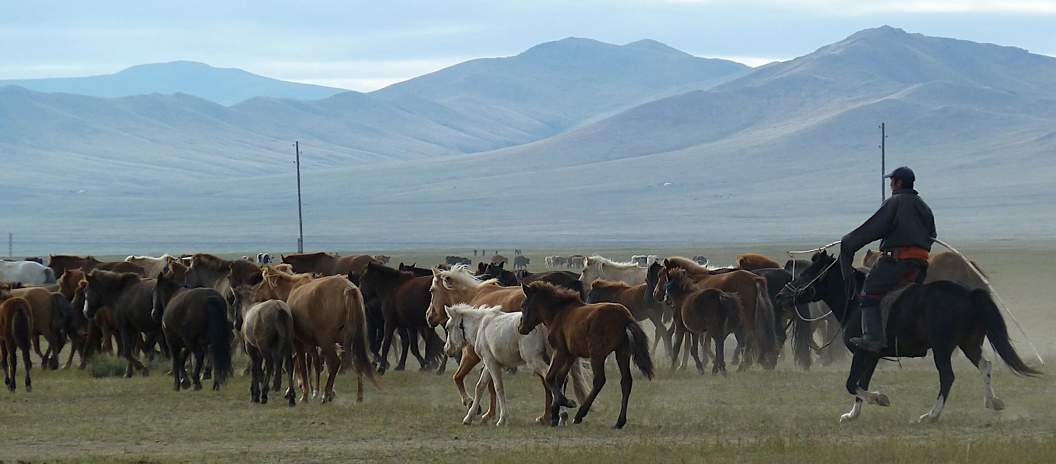
A large herd of horses moves across a grassy steppe in Mongolia with mountains in the background, while a person on horseback accompanies them.
A herd of horses managed by a local herder in the steppe landscape of Hustai National Park.

Hustai National Park history and protected-area timeline

The modern history of Hustai National Park is closely tied to one of the most celebrated wildlife reintroduction efforts of the late twentieth century. In 1992, an international project was launched to return the Przewalski's horse, also called the Takhi, to its native Mongolian range after the species had vanished from the wild.

One year later, in 1993, the Mongolian Government declared the Hustai area a Specially Protected Area, acknowledging both the reintroduction effort and the broader ecological value of the Khustai Mountains. Early management of the park was carried out by the Mongolian Association for the Conservation of Nature and the Environment, marking it as the first protected area in Mongolia managed by a dedicated nature conservation organization.

In 2002, the Man and the Biosphere Reserves organization of UNESCO recognized Hustai as part of the world network of biosphere reserves, highlighting its role in biodiversity conservation and sustainable development. The following year, in 2003, the Hustai National Park Trust was established as an independent NGO, signing a contract with the government to take over long-term park management under a formal national park designation.

The Hustai National Park Trust joined the IUCN in 2007, further embedding the park in international conservation networks. Over the years, the Trust has worked with international partners, including the Dutch Government, on a series of phased projects covering biodiversity conservation, management support, sustainable buffer-zone development, and adaptation to changing environmental conditions.

Hustai National Park landscape and geographic character

The landscape of Hustai National Park is shaped by the Khustai Mountains, a relatively modest but ecologically important range in central Mongolia. Ridges, valleys, and gentle slopes alternate across the protected area, creating a varied terrain where elevation, aspect, and water availability produce a patchwork of forest, woodland, shrubland, and open steppe.

The Tuul River, one of Mongolia's significant waterways, runs through the park and contributes to the diversity of the scenery. Along the river corridor, vegetation grows denser and lusher, while higher slopes transition into more open grassland and exposed rock. South- and west-facing slopes dry out into classic steppe conditions, giving way to grass-dominated habitats characteristic of the broader Mongolian-Manchurian grassland.

At the level of the western park boundary, the mountains gradually fade into the open expanses of the Mongolian steppe, producing a continuous gradient between forest-steppe and true steppe. This transition is one of Hustai's defining geographic traits and the reason it supports such a wide array of species within a relatively compact area.

Hustai National Park ecosystems, habitats, and plant life

Hustai protects a richly varied plant base, with several hundred vascular plant species documented, along with mosses, lichens, and fungi. The vegetation reflects the park's position at a forest-steppe boundary, with larch and birch woodlands on suitable slopes giving way to grasslands, shrub thickets, and riparian vegetation along the Tuul River and its tributaries.

This vegetation mosaic creates conditions for both forest-associated and steppe-associated wildlife to coexist. The result is an ecological community that captures much of the character of central Mongolia in a single protected landscape.

The park's diverse plant communities also have value for research and monitoring. New species continue to be documented here, including soil-dwelling invertebrates described from Hustai for the first time, underscoring how much of the park's biodiversity is still being scientifically explored.

Hustai National Park wildlife and species highlights

Wildlife is at the heart of Hustai's identity. The park is best known for its population of Przewalski's horses, the Takhi, which now live as wild, free-ranging animals across its slopes and valleys. Watching these horses graze and move across the steppe has become one of Mongolia's most distinctive wildlife experiences.

Beyond the Takhi, Hustai supports a broad mammal community that includes Altai wapiti, Mongolian gazelle, Siberian roe deer, wild boar, argali sheep, Siberian ibex, Mongolian marmot, Mongolian wolf, Siberian lynx, Pallas's cat, red fox, corsac fox, and European badger. The mix of forest and steppe predators and ungulates reflects the transitional character of the habitat.

Birdlife is exceptionally rich, with more than two hundred recorded species, and has earned Hustai a designation as an Important Bird Area by BirdLife International. Among the regularly encountered species are golden eagle, lammergeier, great bustard, whooper swan, black stork, Daurian partridge, and little owl.

The park also hosts fish, amphibians, and a wide invertebrate fauna, communities that are less visible to visitors but contribute to the overall ecological complexity of the protected area.

Hustai National Park conservation status and protection priorities

Hustai National Park carries significant conservation value at both national and international levels. Its formal designation as a Specially Protected Area in 1993 and its subsequent status as a biosphere reserve under UNESCO's Man and the Biosphere programme reflect the international recognition of its ecological importance.

The park's conservation mission combines ecosystem protection with the recovery of a globally significant species, the Przewalski's horse. Building a sustainable wild population of Takhi within an actively managed landscape has become a model for species reintroduction efforts in similar steppe environments.

Conservation work at Hustai is organized through the Hustai National Park Trust, the first dedicated NGO to manage a national park in Mongolia. The Trust coordinates protection of ecosystems and historical sites, ongoing Takhi monitoring and management, scientific research, ecotourism development, and engagement with the surrounding buffer-zone communities. International partnerships have supported biodiversity surveys, management planning, sustainable livelihood development in adjacent areas, and long-term adaptation strategies.

Hustai National Park cultural meaning and human context

The Hustai region has deep ties to Mongolia's traditional pastoral culture. The buffer zone around the park is home to herding communities whose livelihoods and customs are closely connected to the surrounding steppes and mountains.

The presence of the reintroduced Przewalski's horse also carries cultural resonance, as the Takhi is regarded as a symbolic part of Mongolia's natural heritage. Efforts to balance wildlife conservation with the needs of herder communities have shaped the park's management approach, with buffer-zone development considered a core activity alongside ecological protection.

Historical and archaeological sites within the park are recognized as part of its conservation mandate, linking the natural values of the Khustai Mountains to the broader human story of central Mongolia.

Top sights and standout views in Hustai National Park

Hustai National Park is distinguished by the combination of a successful large-mammal reintroduction story, an accessible location near Ulaanbaatar, and a habitat mosaic that captures the full spectrum of central Mongolian landscapes.

Within a relatively compact area, visitors can move from riverine woodland along the Tuul River, up through mountain ridges of the Khustai range, and out onto open steppe. The park's Important Bird Area status and its rich mammal community add depth to its ecological identity, while its pioneering NGO management model makes it a landmark case study in protected-area governance.

Best time to visit Hustai National Park

The character of a visit to Hustai shifts notably with the seasons. Summer brings warm temperatures, blooming steppe vegetation, and long daylight hours that make wildlife viewing, including Przewalski's horses, more accessible along the park's trails.

Late spring and early autumn often combine pleasant conditions with strong wildlife activity, as animals concentrate near water sources and migratory birds move through the area. Winter transforms the park into a quiet, snow-covered landscape with its own stark beauty, though conditions require more careful preparation and a focus on cold-season wildlife observation.
Monthly climate preview

Measured temperature swings and precipitation patterns across representative coordinates

Hustai National Park Climate Normals and Long Term Weather by Month

Representative coordinate records show significant annual temperature variations and distinct monthly precipitation rhythms for Hustai National Park. Examining the complete twelve month dataset provides detailed monthly temperature averages and precipitation totals for deeper geographic analysis.
Annual mean0 °C
-20 °C19 °C
Jan-20°
Feb-15°
Mar-6°
Apr
May10°
Jun16°
Jul19°
Aug17°
Sep
Oct
Nov-10°
Dec-17°
Warmest month
July

19.2 °C

Coolest month
January

-19.6 °C

Wettest month
July

2.1 mm/day

Driest month
January

0.1 mm/day

Park location guide

Geography guide, regional context, and park location map for Hustai National Park

Hustai National Park park geography, regions, and map view in Mongolia

Understand where Hustai National Park sits in Mongolia through a broader geographic reading of the surrounding landscape, nearby location context, and its mapped position within the national park landscape.

How Hustai National Park fits into Mongolia

Mongolia is a landlocked sovereign state in East Asia, known for its vast steppe landscapes, nomadic culture, and historical significance as the heartland of the Mongol Empire founded by Genghis Khan in 1206. The country has a population of approximately 3.5 million people and is the world's most sparsely populated sovereign state. Ulaanbaatar is the capital and largest city, home to roughly half the population.

Wider geography shaping Hustai National Park in Mongolia

Mongolia is located in East Asia, landlocked between Russia to the north and China to the south. The country occupies the Mongolian Plateau and features diverse terrain including grassy steppe, mountains in the north and west, and the Gobi Desert in the south. It covers 1,564,116 km2, making it the second largest landlocked country in the world.

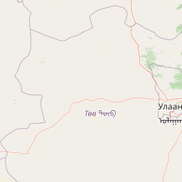
Map view of Hustai National Park

Use this park location map to pinpoint Hustai National Park in Mongolia, understand its exact geographic position, and read its mapped placement within the surrounding landscape more clearly.

Pigeon | © OpenStreetMap contributors

Location context for Hustai National Park

Töv Province
Recorded earthquake history

Review the Historical Earthquake Catalogue for Hustai National Park

Analyze the recorded seismic history of Hustai National Park by reviewing a detailed list of historical events. This MoriAtlas dataset allows you to examine epicentre locations and magnitude metrics near the park, supporting a better understanding of the regional seismic context in central Mongolia.

Hustai National Park Earthquake History

Catalogued events

1 event

Strongest magnitude

Magnitude 4.3

Most recent event

Dec 3, 2005

This history includes earthquakes recorded inside the park or within 50 km of its borders

Explore protected area views, Khustai Mountain terrain, and wild horse habitats in central Mongolia.

Hustai National Park Photos and Landscapes: Visualizing Mongolian Steppe Scenery

Visual documentation captures the varied terrain of Hustai National Park, spanning riverine woodland, mountain ridges, and open Mongolian steppe. Protected area photography reveals the complex ecological gradients and wild habitats defining this central conservation landscape.

A large herd of horses moves across a grassy steppe in Mongolia with mountains in the background, while a person on horseback accompanies them.

A pale brown Przewalski horse with a dark mane and tail grazes in a grassy meadow with two white circular gers visible in the background.

Park atlas

Compare regional steppe conservation landscapes and nearby mountain terrain

Other Parks Near Hustai National Park and Surrounding Protected Areas

Browse protected areas surrounding Hustai National Park to compare regional steppe habitats and mountain forest corridors. Expanding the geographic view helps trace connected ecosystems and similar wildlife reserves across central Mongolia.
National parkMongolia
About 0.4 km away#1 closest

Khustain Nuruu National Park: Mongolia's Steppe Wilderness & Przewalski's Horse Conservation Area

Explore its mapped protected landscape and regional geography.

Khustain Nuruu National Park is a protected area in Mongolia celebrated for its pivotal role in the conservation and reintroduction of the Przewalski's horse, the last truly wild horse species. This national park preserves the unique steppe terrain and rolling hills characteristic of the Mongolian Plateau, serving as a crucial habitat for native wildlife. Understanding Khustain Nuruu National Park provides a focused look into successful wildlife recovery efforts and the geographic context of Central Asian protected lands.

Established
1993
IUCN
II
Relief
Mountain
Scope
Terrestrial
A horizontal watercolor painting depicting a soft-toned mountain range with layered green hills and distant, hazy peaks in pastel pink and purple hues.
Biosphere reserveUlaanbaatar
About 64 km away#2 closest

East

Bogd Khan Uul Biosphere Reserve: Mapped Protected Landscapes and Geographic Overview

Highland ecosystems and forest steppe in the Khentii Mountains.

Rising directly south of Ulaanbaatar, Bogd Khan Uul Biosphere Reserve protects a compact mosaic of habitats including larch forests, Siberian pine stands, and alpine rock. The reserve serves as a critical geographic marker, illustrating the rapid shift from urban fringes to subalpine wilderness while maintaining a history of sacred environmental protection that informs its current status as a biosphere reserve.

Area
673 km²
Established
1996
Relief
Mountain
Climate
Boreal
National parkTöv Province
About 115 km away#3 closest

East

Gorkhi-Terelj National Park: Mapped Protected Landscape in Töv Province

Explore the geographic context and park boundaries.

Gorkhi-Terelj National Park is a designated national park offering rich opportunities for geographic exploration and protected landscape discovery. This entity page provides detailed insights into its mapped boundaries and its position within the regional geography of Töv Province. Understand the specific landform and terrain characteristics that define this protected natural area, central to understanding Mongolia's conservation landscapes.

Area
2,920 km²
Established
1993
IUCN
II
Relief
Mountain
National parkMongolia
About 159 km away#4 closest

West

Khogno Khan National Park: A National Park with Distinct Mongolian Landscape Identity

Explore its mapped terrain and regional geographic context.

Khogno Khan National Park is a designated national park offering a specific focus for protected landscape discovery. Users can explore its geographic placement within Mongolia and understand its role as a mapped natural area. The park's identity as a protected territory provides critical context for those interested in the atlas of East Asian landscapes and regional geography, highlighting a distinct area for geographic study.

Area
841 km²
Established
2003
IUCN
II
Relief
Mountain
Wildlife reserveKhentii Province
About 220 km away#5 closest

Northeast

Khan Khentii Strictly Protected Area: Geographic Overview and Protected Landscape Mapping

Eastern Mongolia wilderness and Khentii mountain terrain

Explore the expansive reaches of Khan Khentii Strictly Protected Area, a cornerstone of Mongolian conservation. This reserve shields intact taiga forests, river valley habitats, and the historic Burkhan Khaldun mountain from industrial activity, preserving one of the most significant mountain wilderness regions in the province of Khentii.

Area
12,270 km²
Established
1992
IUCN
Ib
Relief
Mountain
A horizontal watercolor illustration depicting a soft, green landscape with distant rolling hills, foreground meadows, and flowering bushes under a pale sky.
Protected areaArkhangai Province
About 222 km away#6 closest

West

Ögii Lake Protected Area: A Comprehensive Geographic Overview of the Mongolian Steppe

Freshwater basin and wetland geography in Arkhangai Province

Ögii Lake represents a pivotal protected landscape in central Mongolia, defined by its 25 square kilometer surface area and gentle, shallow underwater topography. This site functions as an ecological nexus for migratory waterbirds and is essential for understanding the transition between open grassland and the mountainous terrain of the Khangai region.

Area
25.7 km²
Established
2006
Relief
Lowland
Access
Access unknown
Nature reserveDornogovi Province
About 301 km away#7 closest

Southeast

Ikh Nartiin Chuluu Nature Reserve: Mapping Granite Outcrops and Steppe in Dornogovi Province

A vital protected sanctuary within the Mongolian Gobi desert landscape

Ikh Nartiin Chuluu Nature Reserve occupies a unique position in the Dornogovi Province of Mongolia, where granite skeletons meet arid plains. The protected area serves as a significant biological stronghold, offering a detailed study of how rocky crevices and sheltered valleys support diverse steppe life. Use this atlas resource to understand the park boundaries, terrain features, and regional landscape context that make this reserve a reference site for desert conservation.

Area
660 km²
Established
1996
Relief
Upland
Climate
Arid
National parkMongolia
About 331 km away#8 closest

West

Khangai Nuruu National Park: Discover Mongolia's Protected Mountain Landscape and Atlas Context

Explore mapped boundaries and diverse ecosystems across its terrain.

Khangai Nuruu National Park stands as a vast national park in central Mongolia, characterized by its diverse protected landscapes and significant geographic scope. Spanning the Khangai Mountains, it presents a remarkable ecological transition from alpine meadows and taiga forests to steppe and riparian environments. This park offers a rich atlas exploration opportunity, highlighting its mapped boundaries and the unique regional geography that defines its protected status, making it a key point of discovery for understanding Mongolian conservation areas.

Area
8,885 km²
Established
1996
IUCN
II
Relief
Mountain

Common questions about visiting, size, designation, and location context for Hustai National Park

Hustai National Park FAQs for park facts, access, geography, and protected area context

Find quick answers about Hustai National Park, including protected-area facts, park geography, trail and visitor context, and how the park fits into its surrounding country and regional landscape.
MoriAtlas Explorer

Continue Your Protected Areas Search Across the Global Atlas

Deepen your exploration by continuing the structured search for national parks and protected areas worldwide. Utilize the comprehensive filtering capabilities to compare different conservation landscapes and refine your understanding of global park geography. Discover more about the distribution and characteristics of protected natural areas.

Global natural geography