Mori Atlas logo
Nature reserveIllamurta Springs Conservation Reserve

A rare permanent spring and cultural refuge within the rugged foothills of the James Range

Illamurta Springs Conservation Reserve: Exploring the Arid Oasis and Mapped Desert Landscape

Illamurta Springs Conservation Reserve represents a vital desert oasis in the Northern Territory of Australia. Centred on a permanent water source at the southern foothills of the James Range, this protected area preserves an ecological refuge within the arid interior. The landscape integrates diverse heritage, including Western Arrente cultural landmarks and colonial-era frontier history, providing a unique vantage point for understanding the geography of central Australia.

arid landscapedesert springpermanent springJames Rangecentral AustraliaNorthern Territory

Illamurta Springs Conservation Reserve

Nature reserve

Park overview

Structured park overview, official facts, and landscape profile for Illamurta Springs Conservation Reserve

Illamurta Springs Conservation Reserve park facts, protected area profile, and essential visitor context

Review the core facts for Illamurta Springs Conservation Reserve, including designation, size, terrain, visitor scale, habitats, and operating context in one park-focused overview.

About Illamurta Springs Conservation Reserve

Illamurta Springs Conservation Reserve sits in one of the most atmospheric stretches of inland Australia, where red ranges, spinifex plains, and isolated springs shape the rhythm of the land. The reserve takes its name from a permanent spring fed by the southern foothills of the James Range, a source of water that has long given the area an outsize importance despite the small size of the protected area itself. At only about 1.29 square kilometres, Illamurta Springs is modest in extent, yet like many Australian spring reserves it punches well above its areal weight because of the contrast it offers to the surrounding arid country.

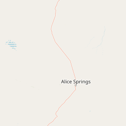
The reserve lies in the locality of Ghan, roughly 42 kilometres south of Hermannsburg and about 140 kilometres west of Alice Springs. This places it within the broader landscape shaped by the MacDonnell Ranges and the sweeping plains, saltpans, and rocky foothills that stretch west toward Lake Amadeus and Uluru. The James Range itself rises as a long line of rugged country, and the spring at its southern base functions as a natural gathering point for wildlife, vegetation, and people in an environment where surface water is otherwise scarce and seasonal.

What makes Illamurta Springs particularly distinctive is the way natural and cultural heritage combine in a single small site. The spring is tied to the Western Arrente people's deep connection to country, especially through the Kunnea Snake Dreamtime narrative, and archaeological finds such as grindstones in and around the reserve document thousands of years of presence in the region. Layered onto this long Indigenous history is a more recent chapter of European exploration, pastoralism, and colonial administration, captured in the reserve's ruined police station and in the broader story of early contact-era anthropology in central Australia. Today the reserve is managed by the Parks and Wildlife Commission of the Northern Territory and is recognised for its heritage value at both national and territory levels.

Quick facts and research context for Illamurta Springs Conservation Reserve

Illamurta Springs is a small conservation reserve in the Northern Territory of Australia, situated in the locality of Ghan between Hermannsburg and Alice Springs. It covers about 1.29 square kilometres and centres on a permanent spring at the southern foothills of the James Range.

The reserve was established in 1969 and is managed by the Parks and Wildlife Commission of the Northern Territory. Its protected status has been reinforced by its listing on the Register of the National Estate in 1980 and on the Northern Territory Heritage Register in 1994.

Protection and recognition

Terrestrial protected area established in 1994 with documented conservation scope.

Illamurta Springs Conservation Reserve Protection Status and Designation History

Illamurta Springs Conservation Reserve maintains documented terrestrial protection status established in the year 1994. Official records outline the designation history and management scope without imported international recognition sources.

Protection details

Protection scope
Terrestrial
Designated year
1994
Transboundary protection
No
Park context

Deeper park guide and search-rich context for Illamurta Springs Conservation Reserve

Illamurta Springs Conservation Reserve history, landscape, wildlife, and travel context

Explore Illamurta Springs Conservation Reserve through its history, landscape character, ecosystems, wildlife, conservation priorities, cultural context, and seasonal travel timing in a structured park guide built for atlas discovery and search intent.

Why Illamurta Springs Conservation Reserve stands out

Illamurta Springs Conservation Reserve is best known for its permanent, desert-fringe spring, which creates a small but ecologically significant oasis in the arid interior of the Northern Territory. The reserve is also strongly associated with Western Arrente cultural heritage, being part of the Kunnea Snake Dreamtime landscape, and with the ruins of the Illamurta Springs Police Station, an artefact of late nineteenth century frontier administration in central Australia.

Illamurta Springs Conservation Reserve history and protected-area timeline

The cultural history of Illamurta Springs runs far deeper than any European record. The Western Arrente peoples have lived in the region around the spring for thousands of years, and the site forms part of the Kunnea Snake Dreamtime story. Artefacts such as grindstones found in and around the reserve attest to the long continuity of occupation and use of the area, reflecting the spring's central role as a gathering place and resource hub in an arid landscape.

European contact began in 1874, when the explorer Ernest Giles passed through the area during his inland explorations. Settlement followed almost a decade later, with cattle stations established across the surrounding country. The pastoral expansion brought conflict with Aboriginal groups, and in response the Illamurta Springs Police Station was established in 1893. The station was built primarily to manage resistance to pastoralists, much of which took the form of spearing stock. Once that pressure eased, the facility shifted in role and served until 1912 as an administration centre for the distribution of rations to Aboriginal people.

The reserve also has an unusual place in the history of Australian anthropology. Mounted Constable Ernest Cowle, posted at Illamurta Springs, collaborated with Walter Baldwin Spencer and Frank Gillen on the influential work "The Native Tribes of Central Australia" (1899), which John Mulvaney later described as one of Australia's most significant contributions to the history of ideas.

As a formal protected area, Illamurta Springs was established in 1969 under the management of what is now the Parks and Wildlife Commission of the Northern Territory. It was added to the Register of the National Estate in 1980 and, recognising its broader heritage value, was listed on the Northern Territory Heritage Register on 14 September 1994.

Illamurta Springs Conservation Reserve landscape and geographic character

The landscape of Illamurta Springs Conservation Reserve is defined by the meeting of two very different elements: arid rocky uplands and a single, reliable source of water. The southern foothills of the James Range form a long, weathered edge of broken country, with rocky slopes and stony outcrops descending toward the reserve. These hills are part of the broader system of ranges that characterises central Australia and give the area its strong sense of geological character.

At the foot of those hills, the permanent spring produces the reserve's defining feature: a localised pocket of moisture and greenery in an otherwise dry environment. The spring supports a small oasis of vegetation that contrasts with the surrounding spinifex-dominated plains and open mulga country typical of the region.

Beyond the reserve, the wider setting is shaped by near-desert conditions, with vast distances between water sources, deeply baked soils, and skies that stretch broadly across the inland plains. The result is a classic central Australian scene in which a single spring anchors a much larger and harshly beautiful landscape.

Illamurta Springs Conservation Reserve ecosystems, habitats, and plant life

The ecological identity of Illamurta Springs is built around the contrast between a permanent groundwater-fed spring and the surrounding arid zone. In a region where surface water is scarce and largely seasonal, the spring sustains a small but ecologically meaningful oasis. Vegetation clusters around the water source, creating a localised refuge where plant life persists in markedly greater density than across the broader landscape.

The reserve sits within the arid and semi-arid country of central Australia, an environment dominated by hardy vegetation adapted to long dry periods, intense heat, and erratic rainfall. Hard spinifex grasslands, scattered shrubs, and open woodland are typical of the surrounding terrain, while the spring itself supports a richer mix of plant life drawn to permanent moisture.

Because the spring is one of very few reliable water sources in this part of the Northern Territory, the reserve also functions as an important node for wildlife movement and habitat connectivity in the surrounding ranges and plains. This places the small protected area into a much larger ecological context, where it serves as a biological anchor amid an otherwise water-limited regional landscape.

Illamurta Springs Conservation Reserve wildlife and species highlights

Wildlife at Illamurta Springs is closely tied to the presence of a permanent spring in otherwise dry country. The reserve's reliable water source draws animals from the surrounding ranges and plains, making it an important point of concentration for fauna in the region.

The dryland habitats beyond the spring support the typical mix of central Australian species, including reptiles, small mammals, and birds adapted to arid conditions. Near the water itself, activity levels and species variety tend to be higher, with birds in particular using the spring area as a focal point in an environment where such resources are scarce.

Because the reserve is small in area, its wildlife value lies less in providing a vast habitat and more in sustaining a key watering point that supports a wider ecological network across the southern James Range and the surrounding plains.

Illamurta Springs Conservation Reserve conservation status and protection priorities

Although Illamurta Springs is tiny in geographic footprint, its conservation significance is unusually high for its size. By protecting a single permanent spring at the base of the James Range, the reserve safeguards a critical water resource in a landscape where reliable surface water is extremely rare, helping to maintain ecological function across the surrounding arid country.

Recognition of this value has been formalised through heritage listings in addition to its conservation status. The reserve was placed on the Register of the National Estate in 1980 and was added to the Northern Territory Heritage Register in 1994, reflecting its combined natural and cultural importance within Australia's protected-area network.

Management by the Parks and Wildlife Commission of the Northern Territory gives the reserve an institutional foundation for ongoing protection. In this way, Illamurta Springs illustrates how even very small reserves can have outsized conservation meaning when they protect scarce, landscape-defining resources like desert springs.

Illamurta Springs Conservation Reserve cultural meaning and human context

Illamurta Springs sits within a cultural landscape of deep continuity for the Western Arrente people, who have occupied the region for thousands of years. The reserve forms part of the Kunnea Snake Dreamtime story, anchoring the spring within a wider network of inherited knowledge, place, and identity. The presence of artefacts such as grindstones in and around the reserve reflects long-term Indigenous use of the area, including its seasonal resources and the gatherings its permanent water would have supported.

The reserve also carries a significant and more complex colonial-era cultural layer. The ruins of the Illamurta Springs Police Station mark a period of frontier administration that began in 1893 and shifted, after active resistance to pastoralism faded, into the distribution of rations to Aboriginal people. The site's association with Ernest Cowle, Walter Baldwin Spencer, and Frank Gillen's fieldwork in the 1890s gives it an additional, if contested, place in the early history of Australian anthropology.

Together, these elements mean the reserve is not a purely natural site but a layered cultural landscape, in which Indigenous heritage and the material traces of European settlement both sit alongside the spring's enduring presence.

Top sights and standout views in Illamurta Springs Conservation Reserve

Illamurta Springs Conservation Reserve is a small but unusually layered protected area, anchored by a permanent spring at the foot of the James Range in the Northern Territory. Its highlights include its role as a desert-fringe oasis, its strong ties to Western Arrente culture, and its preserved nineteenth-century police station ruins. The reserve's combined natural and cultural heritage, recognised through national and Northern Territory heritage listings, makes it a compact but distinctive destination for understanding the central Australian landscape.

Best time to visit Illamurta Springs Conservation Reserve

The climate of inland central Australia is arid and extreme, with hot summers, cool to cold winters, and highly variable rainfall. Visiting in the cooler months of the Australian winter and early spring is generally the most comfortable time to experience the surrounding country, when daytime temperatures are milder and the rock and range scenery is at its most inviting. The spring itself remains a year-round feature of the landscape, though the contrast between green vegetation and red desert terrain varies with seasonal rainfall in the broader region.

Monthly climate preview

Long-term monthly temperature and precipitation averages for Northern Territory geography

Illamurta Springs Conservation Reserve Annual Climate and Temperature Patterns

Representative coordinate records show measured long-term averages for annual temperature swings and monthly precipitation across Illamurta Springs Conservation Reserve. Reviewing the complete twelve-month profile provides deep analytical insight into regional meteorological normals.
Annual mean22 °C
13 °C31 °C
Jan31°
Feb30°
Mar27°
Apr22°
May17°
Jun13°
Jul13°
Aug15°
Sep21°
Oct24°
Nov28°
Dec29°
Warmest month
January

31 °C

Coolest month
July

12.6 °C

Wettest month
February

1.4 mm/day

Driest month
August

0.1 mm/day

Park location guide

Geography guide, regional context, and park location map for Illamurta Springs Conservation Reserve

Illamurta Springs Conservation Reserve park geography, regions, and map view in Australia

Understand where Illamurta Springs Conservation Reserve sits in Australia through a broader geographic reading of the surrounding landscape, nearby location context, and its mapped position within the national park landscape.

How Illamurta Springs Conservation Reserve fits into Australia

Australia is a constitutional monarchy and federal parliamentary democracy comprising six states and ten territories. With a population of nearly 28 million, it is one of the world's most urbanised countries, with most people concentrated on the eastern seaboard. The country has a high Human Development Index and is known for its cultural diversity, ancient Aboriginal heritage, and unique wildlife.

Wider geography shaping Illamurta Springs Conservation Reserve in Australia

Australia occupies the entire Australian continent, the island of Tasmania, and numerous smaller islands. It is the world's flattest and driest inhabited continent, featuring vast deserts in the interior (the Outback), tropical rainforests along the eastern coast, and a coastline bordering the Indian and Pacific Oceans.

Map view of Illamurta Springs Conservation Reserve

Use this park location map to pinpoint Illamurta Springs Conservation Reserve in Australia, understand its exact geographic position, and read its mapped placement within the surrounding landscape more clearly.

Pigeon | © OpenStreetMap contributors

Location context for Illamurta Springs Conservation Reserve

Northern Territory
Park atlas

Compare surrounding desert reserves and regional protected landscapes

Other Parks and Protected Areas Near Illamurta Springs Conservation Reserve

Browse nearby national parks and protected areas to compare the arid terrain and surrounding geography of central Australia. Examining adjacent reserves provides broader context for regional conservation landscapes and desert ecosystems.
Watercolor painting of a landscape with green valleys, pink and yellow mountain peaks, and distant hills
National parkNorthern Territory
About 6.1 km away#1 closest

North

Finke Gorge National Park: Explore Its Protected Landscape and Geographic Identity

Mapped boundaries and natural terrain within Northern Territory.

Finke Gorge National Park represents a significant protected area within the Northern Territory, Australia. This national park offers valuable insights into the region's geography, mapped landscapes, and natural terrain. Detailed information helps users understand the park's protected boundaries and its role in the broader context of Australian conservation lands, ideal for focused atlas exploration.

Area
452.85 km²
Established
1966
IUCN
V
Visitors
18K annual
A pale, minimalist watercolor painting of an arid, desert-like landscape with sparse green shrubs and grasses against a soft pastel background.
Natural monumentNorthern Territory
About 55 km away#2 closest

Southeast

Henbury Meteorites Conservation Reserve: Geological and Cultural Impact Site Mapping

Northern Territory desert monument and crater field atlas

Henbury Meteorites Conservation Reserve preserves a series of striking impact craters in the heart of the Northern Territory desert. This protected area offers insights into the geological mechanics of meteorite falls and the enduring cultural significance of the site within central Australian history. Its compact crater field creates a distinct topography against the surrounding arid plains, making it a focal point for understanding terrestrial impact morphology.

Area
0.16 km²
Established
1964
IUCN
III
Relief
Lowland
National parkNorthern Territory
About 62 km away#3 closest

Northeast

Tjoritja / West MacDonnell National Park: National Park Atlas and Protected Landscape

Explore the dramatic MacDonnell Ranges terrain and geography.

Delve into the protected geography of Tjoritja / West MacDonnell National Park, a significant national park in Australia's Northern Territory. This landscape features striking mountain formations, deep gorges like Standley Chasm and Glen Helen, and is intrinsically linked to the famous Larapinta Trail and the Arrernte people's cultural heritage. Understanding its mapped boundaries and regional context provides essential insight into this iconic Central Australian protected area.

Area
2,568.61 km²
Established
1992
IUCN
II
Relief
Mountain
Nature reserveNorthern Territory
About 66 km away#4 closest

Northwest

Tnorala Conservation Reserve: Geological Wonders and Protected Landscapes of the Northern Territory

An iconic circular impact crater preserved as a cultural and natural sanctuary

Tnorala Conservation Reserve stands as a sentinel in the Northern Territory, defined by its striking five-kilometre-wide ring of hills. This protected area offers a look at a massive, ancient impact crater remnant that rises sharply from the surrounding desert plains, serving as a critical point of geological interest and a deeply revered sacred site for the Western Arrernte people.

Relief
Mountain
Climate
Arid
Access
Access unknown
Scope
Terrestrial
National parkAustralia
About 82 km away#5 closest

Northeast

West MacDonnell National Park: Australia's Outback Mountain Landscape and Protected Area

Explore mapped gorges, waterholes, and regional geography in the Red Centre.

West MacDonnell National Park serves as a key protected area within Australia's arid interior, delineating the dramatic western MacDonnell Ranges. This national park offers a unique opportunity to study its mapped landscape, characterized by ancient sandstone ridges, deep gorges, and permanent water sources that support endemic biodiversity. Its profound connection to Aboriginal cultural heritage and its status as a conservation reserve make it essential for understanding the geography and protected lands of central Australia's Red Centre.

Area
2,048 km²
Established
1992
IUCN
II
Relief
Mountain
National parkNorthern Territory
About 88 km away#6 closest

West

Watarrka National Park: Central Australian National Park with Iconic Canyon Landscapes

Explore its mapped terrain and protected area geography.

Watarrka National Park, located in the Northern Territory, is distinguished by the dramatic sandstone formations of Kings Canyon. This protected area showcases a unique arid zone biodiversity, including rare plant species and ancient cycad forests. Its geological significance and Aboriginal heritage make it a compelling point of study for understanding Central Australia's natural and cultural landscapes through structured atlas exploration.

Area
1,051.85 km²
Established
1989
IUCN
II
Visitors
176.1K annual
A soft watercolor illustration of a wide, arid landscape with sparse trees, low shrubs, and rolling hills in the background.
Protected areaNorthern Territory
About 91 km away#7 closest

Southwest

Angas Downs Indigenous Protected Area: Geography and Conservation Landscape Overview

A major arid-zone protected area in the Northern Territory

Angas Downs Indigenous Protected Area constitutes a massive, Aboriginal-owned conservation estate in the southern Northern Territory. This arid landscape features diverse geological landforms including alluvial floodplains, limestone plains, and desert oak woodlands. Managed by the Imanpa community, the area demonstrates effective Indigenous-led conservation strategies for recovering habitats and protecting culturally significant sites in the Australian desert.

Area
3,205 km²
Established
2009
IUCN
VI
Relief
Upland
A horizontal watercolor painting showing stylized soft green, orange, and pale yellow hills under a white sky.
Nature reserveNorthern Territory
About 98 km away#8 closest

East

Rainbow Valley Conservation Reserve: Geological Atlas and Protected Landscape Mapping

Examining the arid-zone terrain of Northern Territory, Australia.

The Rainbow Valley Conservation Reserve is a significant protected landscape known for its 350-million-year-old banded sandstone bluffs and diverse arid-zone habitats. This overview provides a focused look at the park's geological structure, claypan terrain, and its status as a vital site for Aboriginal heritage, offering a clear understanding of its place within the broader Northern Territory geographic context.

Area
24.83 km²
Established
1990
IUCN
V
Visitors
6.8K annual

Common questions about visiting, size, designation, and location context for Illamurta Springs Conservation Reserve

Illamurta Springs Conservation Reserve FAQs for park facts, access, geography, and protected area context

Find quick answers about Illamurta Springs Conservation Reserve, including protected-area facts, park geography, trail and visitor context, and how the park fits into its surrounding country and regional landscape.
MoriAtlas Explorer

Continue Your Protected Areas Search Across the Global Atlas

Deepen your exploration by continuing the structured search for national parks and protected areas worldwide. Utilize the comprehensive filtering capabilities to compare different conservation landscapes and refine your understanding of global park geography. Discover more about the distribution and characteristics of protected natural areas.

Global natural geography