

Mori Atlas logo
Nature reserveIluka Nature Reserve

Mapping the distinct ecological transition from coastal sand dunes to ancient rainforest remnants.

Iluka Nature Reserve: A Protected Littoral Rainforest Landscape in New South Wales Australia

Iluka Nature Reserve preserves a globally significant fragment of littoral rainforest along the coast of New South Wales. As part of the Gondwana Rainforests heritage, the protected area showcases a compressed sequence of vegetation communities, where salt-tolerant dune scrub transitions rapidly into a lush, closed-canopy interior. This mapped landscape provides essential habitat connectivity between the Pacific shoreline and the inland forest regions.

coastal reservelittoral rainforestnature reserveNew South WalesUNESCO World HeritageGondwana Rainforests

Iluka Nature Reserve

Nature reserve

Park overview

Structured park overview, official facts, and landscape profile for Iluka Nature Reserve

Iluka Nature Reserve park facts, protected area profile, and essential visitor context

Review the core facts for Iluka Nature Reserve, including designation, size, terrain, visitor scale, habitats, and operating context in one park-focused overview.

About Iluka Nature Reserve

Iluka Nature Reserve is a compact but botanically important protected area on the far north coast of New South Wales. Although the reserve covers only a small area, it preserves an exceptional ecological transition, from frontal coastal dunes stabilized by hardy strand vegetation, through wet heath and casuarina-dominated woodland, into tall subtropical rainforest in the most sheltered inland sections.

The reserve's rainforest is the centerpiece of its identity. Littoral rainforest is a globally restricted vegetation type that occurs only where warm, humid conditions meet a sheltered coastal setting, and the Southern Australian stands are among the most southerly examples in the world. The Iluka rainforest is included in the Coastal group of the Gondwana Rainforests, a serial UNESCO World Heritage property that links a chain of rainforest reserves across eastern Australia that share lineages dating back to the ancient Gondwanan forests.

Beyond its rainforest significance, Iluka is also valued for its wildlife. Marsupials such as wallabies, kangaroos, wombats, and echidnas inhabit the reserve, and the area is particularly popular with birdwatchers, who have documented a large number of native bird species within the reserve and along its coastline. The combination of dune ecosystems, rainforest, freshwater influences, and adjacent beach environments gives Iluka a layered biodiversity profile that is unusual for a reserve of its size.

Quick facts and research context for Iluka Nature Reserve

Iluka Nature Reserve is a protected area managed by the NSW National Parks and Wildlife Service, established in July 1976. It sits on the far north coast of New South Wales, adjacent to the small coastal town of Iluka and within the Northern Rivers region.

The reserve covers a small land area but protects an unusually diverse range of plant communities, from coastal dune vegetation to littoral rainforest. It is included in the Gondwana Rainforests UNESCO World Heritage site and was added to the Australian National Heritage List in 2007, giving it recognition at both international and national levels.

Protection and recognition

Documented terrestrial conservation scope and official establishment records

Iluka Nature Reserve Protection Status and Designation History

Terrestrial protection status for Iluka Nature Reserve dates back to the 1986 establishment year recorded in official records. Conservation scope details highlight the documented designation framework and management context without international recognition sources.

Protection details

Protection scope
Terrestrial
Designated year
1986
Transboundary protection
No
Park context

Deeper park guide and search-rich context for Iluka Nature Reserve

Iluka Nature Reserve history, landscape, wildlife, and travel context

Explore Iluka Nature Reserve through its history, landscape character, ecosystems, wildlife, conservation priorities, cultural context, and seasonal travel timing in a structured park guide built for atlas discovery and search intent.

Why Iluka Nature Reserve stands out

Iluka Nature Reserve is best known for protecting one of the last remaining stands of littoral rainforest in the Southern Hemisphere. This vegetation type grows in the narrow coastal strip where rainforest conditions meet sandy beach and dune environments, creating a distinctive ecological interface. The reserve is also recognized for the rare coastal emu, a population of particular interest to visitors, researchers, and conservation programs. Together, the heritage-listed rainforest, the dune-to-rainforest transition, and the rich birdlife make Iluka stand out as a small but unusually diverse coastal reserve.
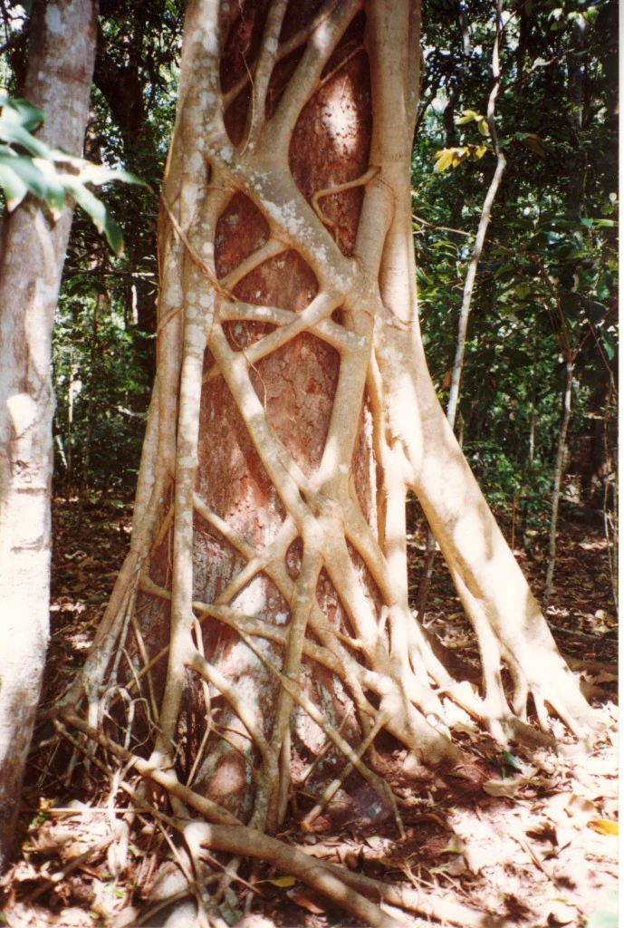
A close-up view of a large Ficus watkinsiana strangler fig wrapping its aerial roots tightly around the trunk of a host tree in a dense forest.
A strangler fig growing around a host tree within the littoral rainforest of Iluka Nature Reserve.

Iluka Nature Reserve history and protected-area timeline

Iluka Nature Reserve was gazetted as a protected nature reserve in July 1976, formalizing long-standing recognition of the area's ecological importance. Its establishment was driven by the need to protect the remaining littoral rainforest on the New South Wales north coast, much of which had been reduced elsewhere by clearing for agriculture and coastal development.

In 1986, the rainforest values of the region received international recognition when the Gondwana Rainforests of Australia were inscribed on the UNESCO World Heritage List. Iluka was included as part of the Coastal group of that inscription, linking the reserve to a broader network of rainforest sites across eastern Australia.

The reserve's significance was reaffirmed at the national level in 2007, when it was added to the Australian National Heritage List. This listing recognized the reserve as an outstanding example of Australia's natural heritage and reinforced its role as a refuge for littoral rainforest and associated wildlife.

Iluka Nature Reserve landscape and geographic character

The landscape of Iluka Nature Reserve is defined by its position on a narrow coastal strip at the mouth of the Clarence River system, where the environment shifts rapidly from open ocean beach to forested interior. The elevational relief is very low, with most of the reserve sitting only a few meters above sea level, which gives it a distinctive flat, layered character rather than a mountainous one.

Closest to the sea, low frontal dunes are stabilized by tough, salt-tolerant coastal plants that thrive in shifting sand and salt spray. Behind the dunes, a band of wet heath and low coastal woodland transitions into taller forest as soils become more sheltered and moisture-retaining. In the most protected inland sections, this coastal forest deepens into the closed canopy, moisture-rich environment of littoral rainforest.

This compressed succession of vegetation communities in a very small area is one of the reserve's defining physical features. Walkers moving from beach to interior can move through dune scrub, open woodland, rainforest margins, and full rainforest within a short distance, making the landscape feel like a transition zone between very different ecological worlds.

Iluka Nature Reserve ecosystems, habitats, and plant life

The ecological identity of Iluka Nature Reserve is built around the dramatic ecological compression that occurs along its short coastal-to-interior gradient. In a small area, the reserve encompasses coastal strand vegetation, wet heath, low coastal woodland, scrub margins, and tall closed rainforest, each stage shaped by exposure, soil depth, salt influence, and freshwater availability.

The rainforest itself is the most ecologically distinctive feature. Littoral rainforest is a rare vegetative formation restricted to sheltered coastal sites in eastern Australia, and the Iluka example is recognized as part of the Gondwana Rainforests World Heritage complex because of its ancient plant lineages and the connections it shares with broader eastern Australian rainforest systems. The rainforest canopy, understory, and ground layers create shaded, humid microclimates that contrast strongly with the sun-exposed dunes nearby.

Freshwater influence from nearby creek lines and the broader river system adds another ecological dimension, supporting moist-soil plant communities and creating transition zones where rainforest and wetland species coexist. This layering of habitat types within a small reserve gives Iluka a biodiversity profile that punches well above its size.

Iluka Nature Reserve wildlife and species highlights

Wildlife at Iluka Nature Reserve reflects the diversity of its habitats. The mosaic of dunes, woodland, and rainforest supports healthy populations of common Australian marsupials, including wallabies, kangaroos, wombats, and echidnas, which find both shelter and varied food resources across the different vegetation zones.

Birdlife is one of the reserve's standout features. More than 140 bird species have been recorded in and around Iluka, drawn by the combination of rainforest, coastal scrub, wetland edges, and shoreline habitats. This mix allows rainforest specialists, open-country birds, waterbirds, and shorebirds to occur in close proximity.

The reserve is particularly associated with the rare coastal emu, a local population of significant conservation interest. The presence of this distinctive bird, alongside more common species across the rainforest and coastal habitats, reinforces the reserve's importance for both casual nature observation and more focused wildlife viewing.

Iluka Nature Reserve conservation status and protection priorities

Iluka Nature Reserve is conservation significant primarily because of the small and increasingly threatened remnants of littoral rainforest that it protects. Littoral rainforest has lost much of its former extent along the eastern Australian coast to clearing, subdivision, and coastal development, making surviving stands like Iluka disproportionately important for the long-term survival of this vegetation type.

Its inclusion in the Gondwana Rainforests UNESCO World Heritage site links the reserve to a broader conservation framework that recognizes the global importance of Australia's ancient rainforest lineages. The 2007 addition to the Australian National Heritage List added a further layer of national recognition, reinforcing the reserve's status as a site of outstanding natural heritage value.

At a more local management level, the reserve is administered by the NSW National Parks and Wildlife Service, and its small size, fragile dune vegetation, and sensitive rainforest understory place it in a category where careful visitor management and habitat protection are ongoing priorities. The combination of formal heritage recognition and active day-to-day reserve management reflects the dual importance of Iluka as both a heritage landmark and a working conservation site.

Top sights and standout views in Iluka Nature Reserve

The standout features of Iluka Nature Reserve are its compressed sequence of coastal and rainforest habitats and the heritage recognition that comes with it. In a short walk, visitors move from open frontal dunes through coastal scrub and into tall littoral rainforest, experiencing multiple vegetation worlds in a single reserve.

Equally distinctive are the formal conservation accolades attached to the site. As part of the Gondwana Rainforests UNESCO World Heritage area and a listed entry on the Australian National Heritage List, the reserve carries recognition far beyond what its size might suggest, anchoring it as a key node in the broader story of eastern Australia's ancient rainforests.

Best time to visit Iluka Nature Reserve

Iluka Nature Reserve can be appreciated at any time of year, but the experience changes with the seasons. Spring and summer bring warmer temperatures, active rainforest growth, vibrant flowering and fruiting cycles, and high bird activity, including breeding plumage and increased vocalizations, which are especially rewarding for birdwatchers.

Autumn offers cooler, often calmer conditions, with rainforest colors shifting and fewer visitors on the trails. Winter is generally mild on the New South Wales north coast, with cooler air and reduced humidity making longer walks along the dunes and through the rainforest more comfortable, though bird diversity may be slightly lower than in warmer months. The reserve's coastal location means weather can shift quickly, and visitors should expect a mix of sun, sea breeze, and occasional rain in any season.

Monthly climate preview

Long-term temperature ranges and monthly precipitation distributions across representative coordinates

Iluka Nature Reserve Climate Normals and Annual Weather Patterns

Iluka Nature Reserve records measured monthly mean temperatures spanning from fourteen to nearly twenty-five degrees Celsius alongside varying daily precipitation rates. Analyzing the complete twelve-month climatological record provides detailed context for regional temperature shifts and historical moisture trends.
Annual mean20 °C
15 °C25 °C
Jan25°
Feb24°
Mar23°
Apr21°
May18°
Jun16°
Jul15°
Aug16°
Sep18°
Oct20°
Nov22°
Dec24°
Warmest month
January

24.8 °C

Coolest month
July

14.7 °C

Wettest month
February

5.9 mm/day

Driest month
September

1.4 mm/day

Park location guide

Geography guide, regional context, and park location map for Iluka Nature Reserve

Iluka Nature Reserve park geography, regions, and map view in Australia

Understand where Iluka Nature Reserve sits in Australia through a broader geographic reading of the surrounding landscape, nearby location context, and its mapped position within the national park landscape.

How Iluka Nature Reserve fits into Australia

Australia is a constitutional monarchy and federal parliamentary democracy comprising six states and ten territories. With a population of nearly 28 million, it is one of the world's most urbanised countries, with most people concentrated on the eastern seaboard. The country has a high Human Development Index and is known for its cultural diversity, ancient Aboriginal heritage, and unique wildlife.

Wider geography shaping Iluka Nature Reserve in Australia

Australia occupies the entire Australian continent, the island of Tasmania, and numerous smaller islands. It is the world's flattest and driest inhabited continent, featuring vast deserts in the interior (the Outback), tropical rainforests along the eastern coast, and a coastline bordering the Indian and Pacific Oceans.

Map view of Iluka Nature Reserve

Use this park location map to pinpoint Iluka Nature Reserve in Australia, understand its exact geographic position, and read its mapped placement within the surrounding landscape more clearly.

Pigeon | © OpenStreetMap contributors

Location context for Iluka Nature Reserve

New South Wales

Visual exploration of coastal dunes and ancient littoral rainforest habitats

Iluka Nature Reserve Photos and Landscape Scenery

Photographic records capture the compressed transition from open coastal dunes to dense subtropical rainforest canopy within Iluka Nature Reserve. Visual documentation provides essential context for studying the rare plant communities and protected coastal environments of New South Wales.

A close-up view of a large Ficus watkinsiana strangler fig wrapping its aerial roots tightly around the trunk of a host tree in a dense forest.

Park atlas

Compare coastal reserves, littoral rainforest remnants, and regional protected landscapes.

Other Parks Near Iluka Nature Reserve and Protected Areas in the Surrounding Region

Browsing other parks near Iluka Nature Reserve reveals connected ecological corridors and diverse coastal habitats across the surrounding New South Wales region. Comparing adjacent protected areas provides wider context for ancient rainforest lineages and transitional dune ecosystems.
Watercolor painting showing a coastal landscape with a body of water, trees, and distant hills under a soft pastel sky
National parkNew South Wales
About 0.5 km away#1 closest

North

Bundjalung National Park: New South Wales Protected Landscape Atlas Entry

Explore its unique coffee rock formations and Bundjalung heritage.

Bundjalung National Park is a significant protected area on the coast of New South Wales, Australia, renowned for its distinctive coffee rock formations and coastal heathland ecosystems. This park offers a rich landscape for atlas exploration, showcasing unique geological features along its beaches and headlands. Understanding its geography and protected boundaries provides crucial context for appreciating its natural and cultural significance within the broader regional landscape.

Area
210 km²
Established
1980
IUCN
II
Relief
Lowland
National parkNew South Wales
About 7 km away#2 closest

South

Yuraygir National Park: New South Wales Protected Area Geography and Landscape Atlas

Discover mapped boundaries and natural terrain context.

Delve into the detailed geography of Yuraygir National Park, a protected natural landscape in New South Wales, Australia. This entry provides core atlas-relevant information, focusing on its mapped protected area boundaries and the intrinsic geographic character of the region, essential for understanding its place in conservation landscapes.

Area
313.71 km²
Established
1980
IUCN
II
Climate
Temperate
National parkNew South Wales
About 33 km away#3 closest

North

Broadwater National Park: Protected Coastal Wilderness and Geographic Atlas Entry

Coastal rainforest, wetlands, migratory bird habitats, and unique geology.

Broadwater National Park presents a rich protected-area identity within New South Wales, Australia, characterized by its diverse mosaic of coastal rainforests, freshwater swamps, and eucalyptus woodlands. This national park is notable for its unique Coffee Rocks geological formation and its crucial role as a refuge for migratory birds, offering a compelling focus for geographic exploration and atlas-based understanding. Discover the mapped extent and ecological significance of this significant protected landscape.

Area
421 km²
Established
1974
IUCN
II
Relief
Lowland
National parkNew South Wales
About 36 km away#4 closest

Northwest

Bungawalbin National Park: Explore New South Wales National Park Protected Area and Geography

New South Wales National Park Landscape Exploration

Bungawalbin National Park is a national park situated in New South Wales, Australia, offering users a point of reference for understanding protected landscapes. The MoriAtlas platform facilitates exploration of this park's geographic identity, its mapped boundaries, and its role within the regional context of New South Wales. This detailed view is essential for anyone interested in the structured discovery of Australia's protected areas and their natural terrain.

Area
37 km²
Established
1999
IUCN
II
Relief
Lowland
National parkNew South Wales
About 39 km away#5 closest

West

Fortis Creek National Park: A Protected Valley Landscape in Northern New South Wales

Mapped protected area boundaries and regional geographic context.

Fortis Creek National Park preserves a significant valley and creek environment in northern New South Wales, Australia. Established in 1997, it serves as a protected area safeguarding representative riparian and valley ecosystems. The park's landscape, characterized by draining creek corridors toward the Clarence River basin, offers a glimpse into the natural terrain of eastern Australia, distinct from more commonly known coastal or alpine regions.

Area
78 km²
Established
1997
IUCN
II
Scope
Terrestrial
Nature reserveNew South Wales
About 53 km away#6 closest

Southwest

Susan Island Nature Reserve: Protected Rainforest and River Island Geography

Clarence River protected area and biodiversity site

Positioned in the Northern Rivers region of New South Wales, Susan Island Nature Reserve preserves a rare subtropical lowland rainforest remnant on alluvial river soils. The island serves as a vital roosting site for hundreds of thousands of grey-headed flying foxes while supporting extensive native vegetation restoration. This protected area stands as a unique reference site for floodplain ecology and historical vegetation patterns in the Clarence Valley.

Area
0.23 km²
Established
1982
IUCN
IV
Relief
Lowland
Nature reserveNew South Wales
About 60 km away#7 closest

North

Davis Scrub Nature Reserve: Geographic Profile of a New South Wales Rainforest Fragment

Protected basaltic-soil habitat in the Northern Rivers region.

Davis Scrub Nature Reserve functions as an ecologically significant habitat and species management area within New South Wales. Covering a compact but dense 13-hectare fragment of the original Big Scrub, this protected area sits atop nutrient-rich basaltic soils derived from the nearby Mount Warning volcanic complex. It serves as a living record of sub-tropical rainforest canopy structures, featuring dominant Moreton Bay figs and diverse native plant communities that define the regional lowland landscape.

Area
0.13 km²
Established
1980
IUCN
IV
Relief
Upland
National parkNew South Wales
About 70 km away#8 closest

Southwest

Ramornie National Park: National Park Discovery and Geographic Mapping in New South Wales

Explore its mapped boundaries and regional protected landscape identity.

Ramornie National Park stands as a distinct national park within New South Wales, offering users a focal point for understanding protected area geography. This page provides essential atlas-level context, detailing the park's mapped outlines and its placement within the broader regional landscape of Australia. Engage with the core geographic identity of Ramornie National Park, designed for structured discovery and landscape analysis without any operational details.

Area
31.6 km²
Established
1999
IUCN
II
Relief
Lowland

Common questions about visiting, size, designation, and location context for Iluka Nature Reserve

Iluka Nature Reserve FAQs for park facts, access, geography, and protected area context

Find quick answers about Iluka Nature Reserve, including protected-area facts, park geography, trail and visitor context, and how the park fits into its surrounding country and regional landscape.
MoriAtlas Explorer

Continue Your Protected Areas Search Across the Global Atlas

Deepen your exploration by continuing the structured search for national parks and protected areas worldwide. Utilize the comprehensive filtering capabilities to compare different conservation landscapes and refine your understanding of global park geography. Discover more about the distribution and characteristics of protected natural areas.

Global natural geography