Mori Atlas logo
Nature reserveIn den Hiärken

Tracing the mapped boundaries and geographic structure of this unique multi-parcel nature reserve

In den Hiärken Nature Reserve: A Fragmented Mosaic of Protected Wetlands in North Rhine-Westphalia

(Naturschutzgebiet In den Hiärken)

In den Hiärken is a significant nature reserve situated in the district of Steinfurt, North Rhine-Westphalia. The protected area comprises six distinct parcels that preserve a mosaic of wet meadows, open water, and damp grasslands between Ladbergen, Lengerich, and Tecklenburg. This geographic configuration functions as a critical refuge for wading birds and amphibians, serving as an ecologically valuable anchor within the broader regional landscape framed by the Dortmund-Ems Canal and major transport corridors.

wetlandwet meadownature reservewading birdsmeadow birdsamphibians

In den Hiärken

Nature reserve

Park overview

Structured park overview, official facts, and landscape profile for In den Hiärken

In den Hiärken park facts, protected area profile, and essential visitor context

Review the core facts for In den Hiärken, including designation, size, terrain, visitor scale, habitats, and operating context in one park-focused overview.

About In den Hiärken

In den Hiärken is one of many smaller nature reserves that together make up the layered protected-area network of the Steinfurt district in North Rhine-Westphalia. Although modest in scale, it has been recognised since 1992 for its importance in maintaining habitat types that have become increasingly rare in the intensively used agricultural landscape of the Münsterland.

The reserve sits in the transition zone between the sandy soils and farmland of the northern Münsterland and the upland edge that rises toward the Teutoburg Forest near Lengerich and Tecklenburg. Wet, groundwater-influenced soils dominate its parcels, with meadows, ditches, and open water bodies forming habitat complexes that are hard to find elsewhere in the district.

Rather than being a single contiguous block, In den Hiärken consists of six separate parcels. This fragmentation shapes both the experience and the management of the site: each parcel can support slightly different microhabitats, and the network together provides redundancy for species that move between wet meadows, ditches, ponds, and adjacent grassland.

The reserve is also notable for sitting within a busy transport corridor. The Dortmund-Ems Canal, a state road, and the A 1 motorway all border its outer edges. Despite this setting, the combination of canal-side habitats, damp meadows, and small open waters has allowed the area to retain significant ecological value, and the reserve has been expanded over time as additional parcels have been brought under protection.

Quick facts and research context for In den Hiärken

In den Hiärken is a nature reserve (Naturschutzgebiet) in the district of Steinfurt, North Rhine-Westphalia, in the northwestern German region of Münsterland. It was first designated in 1992 under the identifier ST-088 and has been expanded in stages since, growing significantly around the year 2000.

The reserve sits on the territory of three local administrative units: the municipality of Ladbergen, the town of Lengerich (Westphalia), and the town of Tecklenburg. It is bounded on the west by the Dortmund-Ems Canal and on the east by the L 597 and the A 1 motorway. The neighbouring Feuchtgebiet Saerbeck, a much larger wetland reserve of about 243 hectares, lies to its northwest.

Protection and recognition

Documented conservation records and official protected area designation history

In den Hiärken Protection Status and International Recognition Data

Examine the documented protection status, management scope, and official designation history established for In den Hiärken. Review structured conservation records and verified administrative frameworks associated with this protected area.

Protection details

WDPA ID
555560763
Park context

Deeper park guide and search-rich context for In den Hiärken

In den Hiärken history, landscape, wildlife, and travel context

Explore In den Hiärken through its history, landscape character, ecosystems, wildlife, conservation priorities, cultural context, and seasonal travel timing in a structured park guide built for atlas discovery and search intent.

Why In den Hiärken stands out

In den Hiärken is best known for its network of wet grassland and open water habitats that support threatened meadow bird, wading bird, and amphibian populations. Its fragmented, multi-parcel structure across the Ladbergen-Lengerich-Tecklenburg area has allowed it to function as a mosaic of small, ecologically valuable wet habitats rather than a single large reserve.
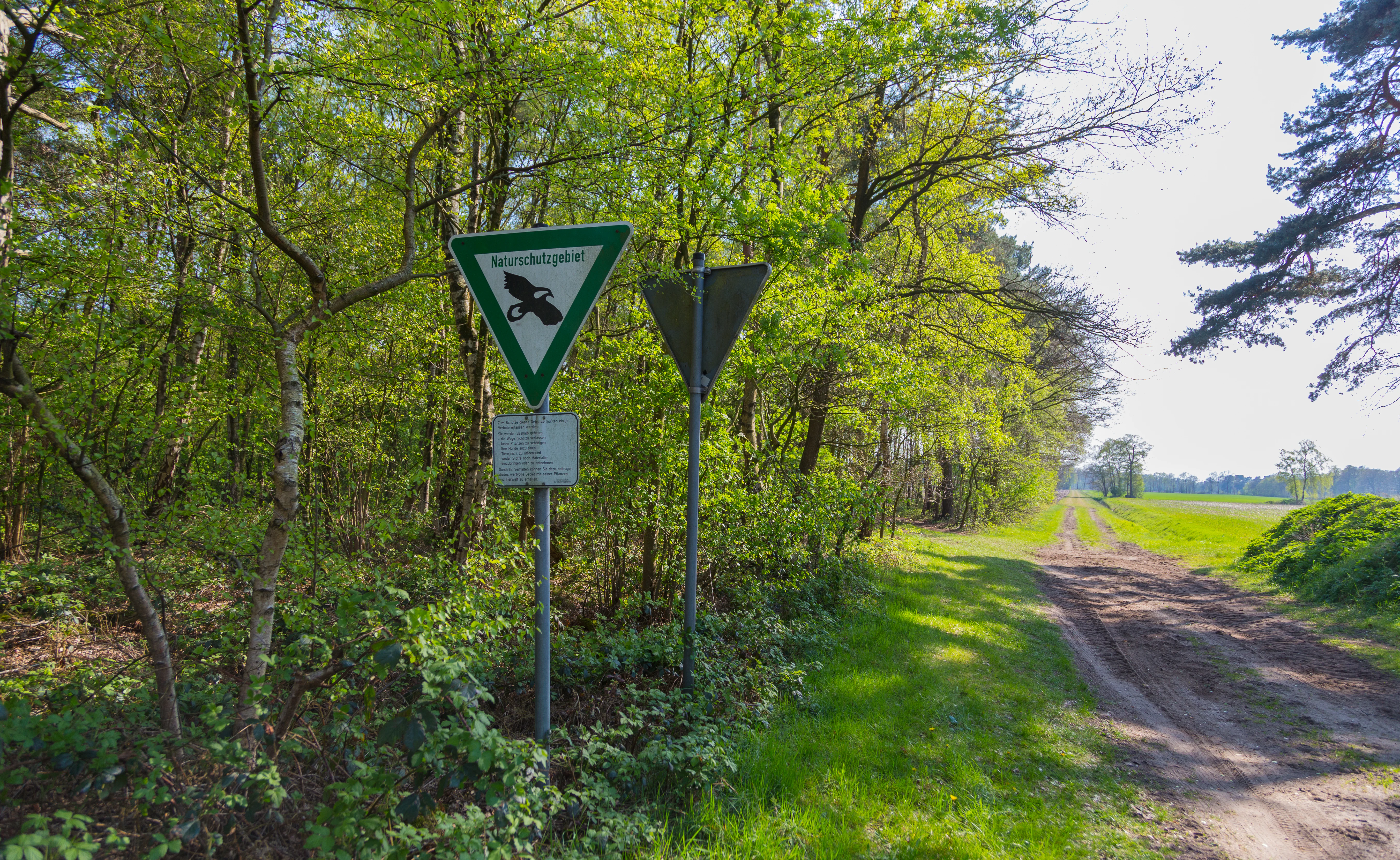
A green triangular nature reserve sign featuring an eagle emblem stands on a metal post next to a dirt trail bordering a forest and an open field.
A nature reserve sign at the edge of the In den Hiärken protected area in Germany.

In den Hiärken history and protected-area timeline

The area that now makes up In den Hiärken was formally designated as a nature reserve in 1992, receiving the official code ST-088. Its original protection covered 166.43 hectares and was introduced to safeguard habitats and species associated with wet open ground in the Steinfurt district.

In 2000, a significant expansion took place. New parcels were added to the reserve, increasing its extent from approximately 139 hectares to 152 hectares. Further adjustments followed over time, so that the present-day reserve reflects an accumulation of incremental additions to the original 1992 designation rather than a single, unchanging boundary.

The reserve's history reflects a broader pattern in the region, in which small, ecologically valuable wet habitats have been brought under protection piece by piece, often in response to local conservation priorities and the gradual loss of similar habitats elsewhere in the intensively farmed Münsterland landscape.

In den Hiärken landscape and geographic character

The landscape of In den Hiärken is shaped by its position west of the core town of Lengerich, on the lower western slopes and lowlands that descend from the Teutoburg Forest edge toward the broader Münsterland plain. The topography is gentle rather than dramatic, dominated by flat to slightly undulating terrain with wet, low-lying pockets.

Water is the defining feature of the reserve's landscape. The Dortmund-Ems Canal runs along its western boundary, and within the protected area itself the land is crossed by drainage features and small water bodies that maintain wet meadow and open water conditions. These moist patches contrast with the surrounding drier farmland and built-up areas, giving the reserve a distinctive character within the regional landscape.

The site is also heavily framed by infrastructure. The L 597 state road and the A 1 motorway run along the eastern side, creating a corridor effect in which the wet meadows and open water parcels sit between a major canal and major road corridors. Despite this, the landscape within the protected parcels retains a quiet, open character defined by grasses, reeds, and shallow water.

In den Hiärken ecosystems, habitats, and plant life

Ecologically, In den Hiärken belongs to the family of wet, open lowland habitats that have become rare in the Münsterland. Its plant communities are centred on open water and damp grassland, with species and vegetation types that are characteristic of undisturbed wet meadows still represented in its parcels.

The reserve's structure, with six separate areas spread across Ladbergen, Lengerich, and Tecklenburg, supports a mosaic of microhabitats. Some parcels favour more established wet grassland, others include sections with open water and emergent vegetation, and the spatial spread helps maintain populations of species that depend on multiple wet habitat types within a relatively small region.

Because the surrounding land is dominated by agriculture and infrastructure, In den Hiärken acts as a refuge. Its habitats provide continuity for species that would otherwise struggle in a heavily modified landscape, and this is the central rationale behind its protection designation.

In den Hiärken wildlife and species highlights

The wildlife focus of In den Hiärken is on species groups that depend on wet, open conditions. Wading birds (Watvögel) and meadow birds (Wiesenvögel) are highlighted in the reserve's designation as characteristic fauna, reflecting the importance of undisturbed wet meadows for breeding and feeding.

Amphibians are another key group. The combination of open water bodies, ditches, and adjacent damp grassland makes the parcels suitable for breeding populations, and connectivity between the different parts of the reserve helps sustain these populations across the landscape.

Invertebrates also play a major role in the reserve's ecological identity. The designation explicitly mentions threatened invertebrate species associated with wet grassland and open water, recognising that the habitat value of In den Hiärken depends as much on these often-overlooked species as on its more visible birds and amphibians.

In den Hiärken conservation status and protection priorities

The conservation purpose of In den Hiärken centres on preserving, developing, and where necessary restoring habitats and biological communities associated with open water and wet grassland. The reserve's designation explicitly aims to maintain rare and partly strongly threatened plant communities and the species that depend on them.

Part of the reserve's importance lies in its position within the Steinfurt network of protected areas. It complements neighbouring sites such as the much larger Feuchtgebiet Saerbeck to the northwest, and together such sites help maintain a regional network of wet habitat refuges in an otherwise intensively used agricultural and transport landscape.

The reserve has also functioned as a tool for incremental habitat protection. Expansions around the year 2000 and later have allowed additional parcels to be brought under formal protection, reflecting an ongoing effort to consolidate and enlarge what began as a relatively modest designation in 1992.

Top sights and standout views in In den Hiärken

In den Hiärken is a modest but tightly focused wet-grassland and open-water nature reserve that, since 1992, has combined formal protection with progressive expansion to safeguard declining habitats in the Münsterland. Its six-parcel structure stretches across Ladbergen, Lengerich, and Tecklenburg, and its borders are defined by the Dortmund-Ems Canal, the L 597 state road, and the A 1 motorway.

The reserve's strongest identity lies in the threatened plant communities and associated fauna of its open water and wet meadows, particularly wading birds, meadow birds, amphibians, and a rich invertebrate fauna. Despite its relatively small size, it forms an important part of the broader network of protected wet habitats in the Steinfurt district.

Best time to visit In den Hiärken

Spring and early summer are generally the most rewarding seasons to experience In den Hiärken, when wet meadows are at their most visually distinctive and the breeding season brings the highest activity levels for meadow birds, wading birds, and amphibians. Late spring in particular can offer a good combination of active birdlife and lush meadow vegetation.

Late summer and early autumn can also be appealing, when seed heads, reeds, and wetland vegetation take on richer colour tones and insect activity remains high. Winter visits tend to be quieter, but the open character of the reserve and its infrastructure-defined boundaries still make it readable as a landscape, even when biological activity is reduced.

Monthly climate preview

Long-term representative monthly temperature ranges and precipitation averages for In den Hiärken

In den Hiärken Climate Normals, Annual Temperature and Precipitation Rhythms

Representative coordinate measurements record monthly mean temperatures spanning from 1.27 degrees Celsius to 18.57 degrees Celsius alongside steady precipitation rates. Detailed twelve-month climate profiles provide comprehensive long-term meteorological data for this protected area.
Annual mean10 °C
1 °C19 °C
Jan
Feb
Mar
Apr
May13°
Jun16°
Jul19°
Aug18°
Sep15°
Oct10°
Nov
Dec
Warmest month
July

18.6 °C

Coolest month
January

1.3 °C

Wettest month
December

2.5 mm/day

Driest month
April

1.5 mm/day

Park location guide

Geography guide, regional context, and park location map for In den Hiärken

In den Hiärken park geography, regions, and map view in Germany

Understand where In den Hiärken sits in Germany through a broader geographic reading of the surrounding landscape, nearby location context, and its mapped position within the national park landscape.

How In den Hiärken fits into Germany

Germany is a federal republic in Western and Central Europe with a population of over 83 million across sixteen constituent states. It is Europe's largest economy by nominal GDP and a major global exporter and importer. The capital is Berlin, and the country borders Denmark, Poland, Czech Republic, Austria, Switzerland, France, Luxembourg, Belgium, and the Netherlands.

Wider geography shaping In den Hiärken in Germany

Germany is located in Western and Central Europe, spanning 357,022 km². It borders Denmark to the north, Poland and the Czech Republic to the east, Austria and Switzerland to the south, and France, Luxembourg, Belgium, and the Netherlands to the west. The country has coastlines on the Baltic Sea and North Sea to the north, with the Alps located in the southern region.

Map view of In den Hiärken

Use this park location map to pinpoint In den Hiärken in Germany, understand its exact geographic position, and read its mapped placement within the surrounding landscape more clearly.

Pigeon | © OpenStreetMap contributors

Location context for In den Hiärken

North Rhine-Westphalia

Visual reference for wet meadows, open water habitats, and regional terrain

In den Hiärken Photos and Protected Landscape Scenery

Visual documentation captures the unique wetland habitats and fragmented multi-parcel character defining In den Hiärken. Examining these protected-area views helps visitors understand the flat terrain, drainage networks, and open water environments shaping the reserve.

A green triangular nature reserve sign featuring an eagle emblem stands on a metal post next to a dirt trail bordering a forest and an open field.

Park atlas

Compare regional wetland reserves and connected nature habitats across the district

Explore Other Parks Near In den Hiärken and Surrounding Protected Landscapes

Browse protected areas near In den Hiärken to evaluate similar wet grassland ecosystems and regional lowland reserves. Expanding the geographic comparison reveals broader ecological networks spanning the Münsterland plain.
A watercolor illustration of a rolling grassy landscape with a cluster of pine and deciduous trees on a white background.
Protected areaGermany
About 6 km away#1 closest

South

Hüttruper Heide Protected Area: Münsterland Heathland Geography and Maps

A compact and scientifically significant nature reserve in North Rhine-Westphalia.

Hüttruper Heide serves as a concentrated example of historic Westfalian heathland. The area features a distinct geological contrast between dry heath ridges and moist, molinia-filled depressions. It remains a key case study in landscape conservation, highlighting the ongoing tension between industrial infrastructure expansion and the survival of rare, fragmented plant habitats.

Area
0.123 km²
Established
1938
Relief
Lowland
Climate
Temperate
A watercolor painting of a soft landscape featuring rolling hills and forested areas under a light pink and yellow sky.
Nature reserveNorth Rhine-Westphalia
About 17 km away#2 closest

Northwest

Moßmörken Nature Reserve: Regional Protected Area and Geographic Atlas Entry

Inland dune and bog landscape in North Rhine-Westphalia, Germany

Moßmörken provides a concentrated study of regional geology and conservation through its varied mosaic of wet grassland, nutrient-poor aquatic habitats, and remnant dunes. As a protected area in the North Rhine-Westphalia region, it represents an essential site for understanding the interplay between post-glacial land-forming processes and local habitat succession in western Germany.

Area
0.129 km²
Established
1995
IUCN
IV
Relief
Lowland
Nature reserveNordrhein-Westfalen
About 19 km away#3 closest

Northwest

Zachhorn Nature Reserve: Protected Heathland and Wetland Landscapes in Nordrhein-Westfalen

Geographic atlas of the Ems valley heathland pond refuge.

Zachhorn is a defined nature reserve in the Steinfurt district, protecting two shallow ponds and surrounding acidic heathland characteristic of the Ems valley lowlands. This site provides a rare, nutrient-poor aquatic environment that supports specialized wetland flora and essential amphibian habitats, forming a distinct piece of the regional conservation mosaic in Nordrhein-Westfalen.

Area
0.214 km²
Established
1990
IUCN
IV
Nature reserveLandkreis Osnabrück
About 23 km away#4 closest

Southeast

Sudendorfer Vennepohl Nature Reserve: Geography and Protected Wetland Atlas

A significant peatland site in Landkreis Osnabrück, Germany.

Explore the geographic identity of Sudendorfer Vennepohl, a protected lowland mire situated in the Osnabrück plain. This site is defined by its sandy substrate, pine forest surroundings, and rare bog flora that thrives in nutrient-poor, acidic conditions. Understanding its origins as an ancient river oxbow provides essential context for the ongoing conservation of this unique wetland relict.

Area
0.204 km²
Established
1951
IUCN
IV
Nature reserveNorth Rhine-Westphalia
About 29 km away#5 closest

South

Wolbecker Tiergarten: Mapped Geography and Protected Forest Landscapes in North Rhine-Westphalia

Ecological continuity and historic hunting park geography.

Wolbecker Tiergarten serves as a prime example of a protected lowland forest ecosystem. Covering nearly 300 hectares, this site offers deep insight into old-growth beech habitats, waterlogged pseudogley soil systems, and diverse insect and amphibian populations. Its well-preserved eighteenth-century hunting park structure provides a unique layer of historical geography to the contemporary nature reserve, making it a critical node in regional biodiversity conservation mapping.

Established
2005
Relief
Lowland
Access
Easy access
Scope
Terrestrial
A soft watercolor painting of a rolling landscape with green fields, scattered evergreen and deciduous trees, and distant hills under a light sky.
Nature reserveNorth Rhine-Westphalia
About 29 km away#6 closest

North

Koffituten Nature Reserve and the Protected Bog Landscapes of North Rhine-Westphalia

A study of raised bog regeneration and inland dune ecosystems.

Koffituten provides a clear look at bog restoration and land management within the Steinfurt district. This nature reserve protects a rare raised bog island alongside a mix of pine-oak forest, fen woodland, and inland dunes. Its compact size and historical restoration work make it a focal point for understanding the interplay between wetland and dry-land habitats in the German lowlands.

Area
0.236 km²
Established
1991
Relief
Lowland
Climate
Temperate
A pale, soft watercolor illustration showing rolling hills, sparse trees, and gentle inland dune slopes under a light sky.
Protected landscapeBerlin
About 32 km away#7 closest

East

Baumberge Protected Landscape: Mapping Berlin's Glacial Sand Dunes and Rare Grassland Habitats

A vital protected ecosystem within the Tegeler Forst region

The Baumberge stand as one of the last remaining open inland dune sites in Berlin, encompassing a fragile 47 hectare mosaic of sand heath and dry grassland. These parabolic dunes provide a critical refuge for warmth-loving invertebrate species and rare flora, anchored by glacial sand deposits dating back to the last ice age. The area offers a significant window into the historical landscape evolution of the northern Berlin glacial valley.

Area
0.47 km²
Relief
Lowland
Climate
Temperate
Access
Easy access
Nature reserveBavaria
About 33 km away#8 closest

Northeast

Steinernes Meer Nature Reserve: Protected Glacial Boulder Landscapes and Geological Terrain

Geological heritage and forest terrain in the Osnabrück district

Steinernes Meer Nature Reserve covers a dense cluster of large glacial erratic boulders known as findlings. These massive stones, left by retreating ice sheets, create a striking, stony forest floor that defines the reserve as a significant geological landmark within the broader regional landscape.

Area
0.127 km²
Established
1937
Relief
Upland
Climate
Temperate

Common questions about visiting, size, designation, and location context for In den Hiärken

In den Hiärken FAQs for park facts, access, geography, and protected area context

Find quick answers about In den Hiärken, including protected-area facts, park geography, trail and visitor context, and how the park fits into its surrounding country and regional landscape.
MoriAtlas Explorer

Continue Your Protected Areas Search Across the Global Atlas

Deepen your exploration by continuing the structured search for national parks and protected areas worldwide. Utilize the comprehensive filtering capabilities to compare different conservation landscapes and refine your understanding of global park geography. Discover more about the distribution and characteristics of protected natural areas.

Global natural geography