


Mori Atlas logo
Wildlife reserveInglewood Migratory Bird Sanctuary

Mapping the riparian cottonwood forests and Bow River corridor within an urban landscape.

Inglewood Migratory Bird Sanctuary: A Federal Wildlife Reserve in Calgary, Alberta Geography

The Inglewood Migratory Bird Sanctuary represents a vital federal protected area situated along the banks of the Bow River in Calgary, Alberta. This wildlife reserve functions as an essential riparian corridor, offering sheltered cottonwood floodplain forest and gravel bar habitat for migratory birds. By examining the sanctuary through its mapped boundaries and river-influenced terrain, you can understand how this unique green space maintains ecological density within a major city.

migratory bird sanctuaryurban wildlife refugeriparian habitatBow River corridorcottonwood floodplainbirdwatching
A flat-style digital illustration of a calm river flowing through a grassy valley toward distant mountains, with a small building nestled near trees under a soft, light-filled sky.

Inglewood Migratory Bird Sanctuary

Wildlife reserve

Park overview

Structured park overview, official facts, and landscape profile for Inglewood Migratory Bird Sanctuary

Inglewood Migratory Bird Sanctuary park facts, protected area profile, and essential visitor context

Review the core facts for Inglewood Migratory Bird Sanctuary, including designation, size, terrain, visitor scale, habitats, and operating context in one park-focused overview.

About Inglewood Migratory Bird Sanctuary

The Inglewood Migratory Bird Sanctuary occupies a stretch of the Bow River valley inside the city of Calgary, in southern Alberta. Established in 1929 and managed by the Canadian Wildlife Service, the sanctuary is among the older federally recognized bird sanctuaries in Canada and remains an important refuge for migratory and breeding birds in a region otherwise dominated by prairie agriculture and urban development.

The sanctuary's ecological value comes largely from its riparian character. The Bow River corridor supports mature cottonwood woodland along the floodplain, with shrubby understory, patches of grassland, and open river surfaces that together create a mosaic of habitats attractive to a wide variety of bird species. Although the broader landscape of southern Alberta is largely open prairie, the dense river-bottom vegetation found here behaves ecologically more like a narrow extension of parkland habitat, providing nesting sites for waterfowl, perching habitat for songbirds, and feeding areas for raptors.

While the sanctuary is modest in size, its location within Calgary gives it a particular importance. It functions as a green artery running through the urban environment, allowing migrant birds to find food, cover, and resting habitat within the city limits. The combination of federal protection, accessible trails, an adjacent nature centre, and proximity to a major population center makes the Inglewood sanctuary an unusual case where wildlife protection, public education, and urban surroundings overlap directly.

The area has also been shaped by the dynamic nature of the Bow River itself. Major flooding in 2013 caused significant changes to the river channel, gravel deposits, and stand of trees, underscoring how the sanctuary's landscape continues to evolve with the hydrology of the river that defines it.

Quick facts and research context for Inglewood Migratory Bird Sanctuary

The Inglewood Migratory Bird Sanctuary is a federally designated bird sanctuary in Calgary, Alberta, established in 1929 and managed by the Canadian Wildlife Service. The sanctuary lies along both sides of the Bow River and includes a mix of riparian woodland, open water, grassland patches, parkland, and portions of a golf course. It supports more than 225 recorded bird species and is best known for its role as a migratory stopover in the Canadian prairies.

Protection and recognition

Documented terrestrial protection scope and official international recognition history.

Inglewood Migratory Bird Sanctuary Protection Status and Conservation Details

Inglewood Migratory Bird Sanctuary maintains a documented terrestrial protection scope within the global conservation framework. Official records compile available designation history and management parameters for detailed protected area research.

Protection details

Protection scope
Terrestrial
Park context

Deeper park guide and search-rich context for Inglewood Migratory Bird Sanctuary

Inglewood Migratory Bird Sanctuary history, landscape, wildlife, and travel context

Explore Inglewood Migratory Bird Sanctuary through its history, landscape character, ecosystems, wildlife, conservation priorities, cultural context, and seasonal travel timing in a structured park guide built for atlas discovery and search intent.

Why Inglewood Migratory Bird Sanctuary stands out

The sanctuary is best known as an urban migratory bird stopover along the Bow River. Its riparian cottonwood forests and open stretches of river channel act as a vital resting and refueling point for songbirds, waterfowl, and raptors during spring and fall migration. The site is also recognized for the unusually high species diversity packed into a small area inside a major Canadian city, and for the role it played as one of the earliest federally protected bird sanctuaries in Alberta.
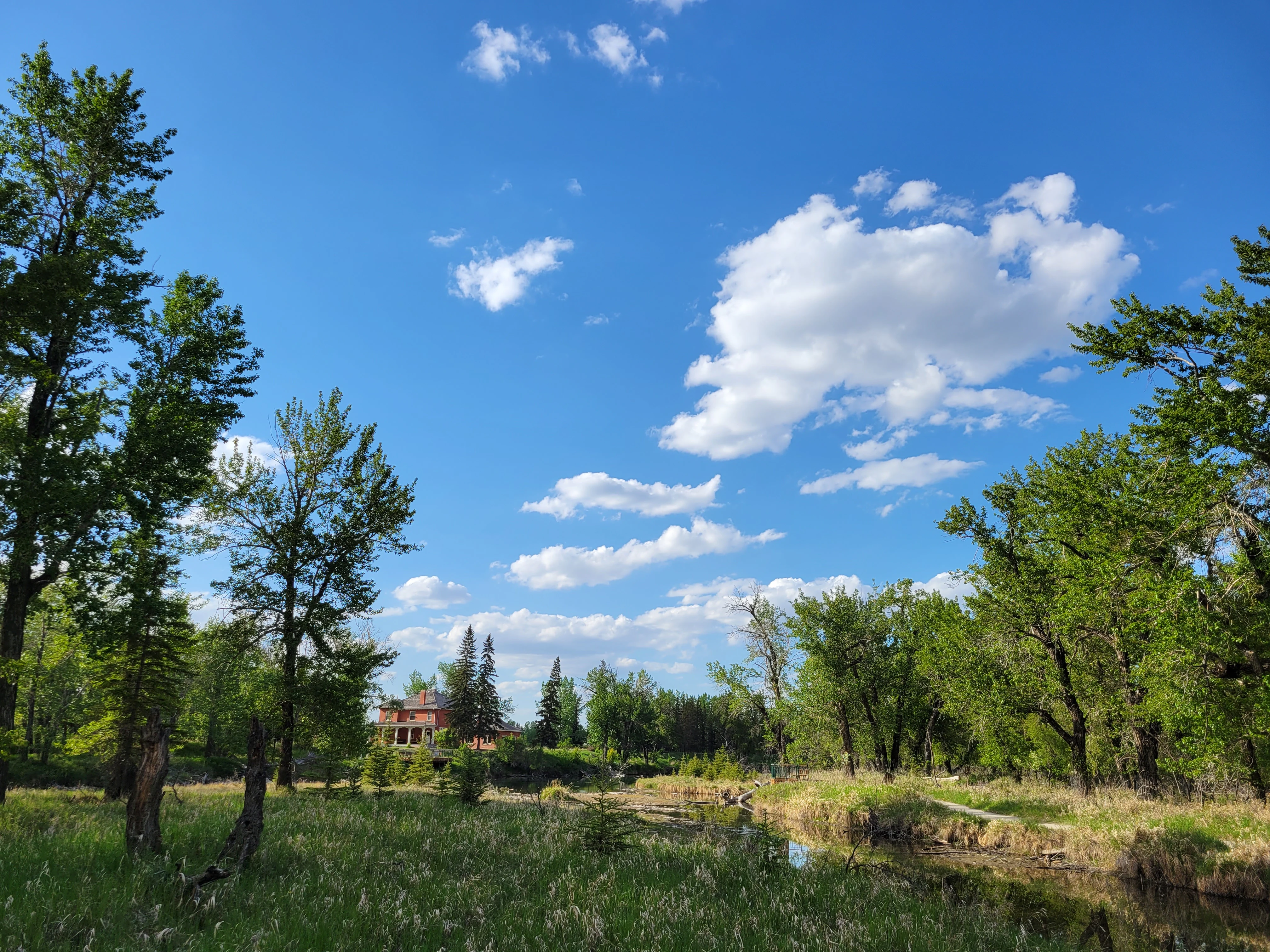
A sunny day view of a grassy meadow and wetlands surrounded by trees, with a building visible in the distant background.
A scenic view of the lush greenery and wetland habitat at Inglewood Migratory Bird Sanctuary.

Inglewood Migratory Bird Sanctuary history and protected-area timeline

The Inglewood Migratory Bird Sanctuary was established in 1929, during the early era of Canadian federal conservation when migratory bird protection was a national priority. Its creation placed it among the earliest federally designated bird sanctuaries in Alberta and gave the Bow River corridor within Calgary a formal protected status for wildlife purposes.

For most of its history the sanctuary has been administered by the Canadian Wildlife Service, the federal agency responsible for migratory bird protection in Canada. Its long-standing presence helped establish the site as a recognized natural area within Calgary long before modern urban conservation efforts became standard in prairie cities.

The most significant recent event in the sanctuary's modern history was the major flooding of 2013, when the Bow River overtopped its banks and reshaped the floodplain. The flood altered channels, deposited gravel, and caused damage to trees and other vegetation, changing parts of the sanctuary's physical landscape and prompting ongoing attention to the resilience of its riparian habitat.

Inglewood Migratory Bird Sanctuary landscape and geographic character

The sanctuary occupies a section of the Bow River valley on both banks of the river within Calgary. Its terrain is shaped by the active floodplain of the Bow River, with flat alluvial benches, gravel bars, riparian woodland, and slow-moving water features defining its character. Unlike the open prairie surrounding Calgary, the valley provides a sheltered corridor of trees and shrubs that contrasts sharply with the surrounding grassland and urban development.

The mosaic of land cover within the sanctuary reflects this river-influenced setting. A small percentage of the sanctuary is made up of floodplain forest, supplemented by patches of grass and shrub vegetation, narrow bands of flowing water, and the majority of the area given over to parkland and portions of a golf course. This blend of natural and managed greenspace still functions ecologically as a riparian refuge within the city, with the river itself acting as the dominant natural force shaping the site.

The 2013 flood is a major part of the sanctuary's recent landscape history. The high water event rerouted channels, exposed gravel deposits, and damaged trees and understory along the riverbanks, leaving visible flood signatures that continue to influence how the sanctuary looks today.

Inglewood Migratory Bird Sanctuary ecosystems, habitats, and plant life

Ecologically, the sanctuary is characterized by its Bow River riparian ecosystem. Mature cottonwood-dominated floodplain forest is the most ecologically distinctive habitat on site, supported by an understory of shrubs, native grasses, and herbaceous vegetation. This woodland is rare in the broader prairie setting of southern Alberta and forms the structural backbone of the sanctuary's biodiversity.

The river itself adds a key aquatic and shoreline dimension. Open water, gravel bars, and seasonally flooded edges create habitat conditions that shift between wetter and drier states, supporting everything from waterfowl to shorebirds and amphibian life. The smaller pockets of grassland and shrub vegetation between the forested areas and the surrounding parkland provide additional edge habitat that is especially valuable for migrating songbirds in spring and fall.

Although the sanctuary is narrow in geographic extent, the layering of forest, shrub, grass, and open water creates a disproportionately rich habitat mosaic. It is this combination, rather than the area itself, that gives the sanctuary its ecological value within the prairie landscape and within the urban environment of Calgary.

Inglewood Migratory Bird Sanctuary wildlife and species highlights

The sanctuary is recognized for its exceptionally high bird diversity, with more than 225 recorded bird species using the site across the year. The majority of these species are observed during the migratory seasons in spring and fall, when the riparian corridor acts as a key stopover point along the broader North American flyway system.

A wide range of waterfowl breeds or stages within the sanctuary, including mallard, northern pintail, common merganser, and Canada goose. Breeding shorebirds such as killdeer and spotted sandpiper, along with gray partridge and American kestrel, also nest on or near the site. During late summer, between mid-August and mid-September, the cottonwood stands along the Bow River concentrate warblers, vireos, chickadees, kinglets, nuthatches, and woodpeckers as they move south.

In winter, open stretches of the Bow River attract large flocks of waterfowl, sometimes exceeding five thousand mallards, alongside smaller numbers of common goldeneye, common merganser, bufflehead, Wilson's snipe, killdeer, bald eagles, and belted kingfishers. Mammals and other wildlife typical of urban riparian zones in Alberta are also present along the corridor, benefiting from the combination of water, vegetation cover, and protected status.

Inglewood Migratory Bird Sanctuary conservation status and protection priorities

The sanctuary holds conservation value as one of the older federally protected migratory bird sanctuaries in Alberta, established in 1929 and continued under the authority of the Canadian Wildlife Service. Its long-standing designation gives the Bow River valley within Calgary a measure of habitat security that would otherwise be difficult to maintain amid dense urban surroundings.

From a conservation perspective, the sanctuary's significance lies less in its absolute size and more in its role within a broader ecological network. It provides breeding habitat, migration stopover habitat, and winter refuge for waterfowl, raptors, and songbirds, and it maintains a functioning floodplain ecosystem in a region where such habitat has been heavily altered. The shelter it offers to migratory species contributes directly to the protection of bird populations that pass through Alberta each year.

The 2013 flood also highlighted the conservation importance of the site. Recovery from the flood, ongoing riparian management, and the need to balance ecological function with recreational and parkland use continue to define the sanctuary's modern conservation profile.

Outside of explicit federal protection, the surrounding parkland and presence of the Inglewood Bird Sanctuary and Nature Centre extend its conservation role by supporting public awareness and education about migratory birds and prairie riparian habitat.

Inglewood Migratory Bird Sanctuary cultural meaning and human context

The sanctuary sits within one of Calgary's older neighbourhoods and forms part of the city's effort to maintain accessible natural space in a rapidly urbanizing prairie region. The presence of a nature centre and well-developed trails reflects a long-standing local interest in birdwatching, environmental education, and outdoor recreation that has grown alongside the sanctuary itself.

For Calgary residents, the site holds a particular identity as one of the closest points inside the city where riparian habitat, migratory birds, and traditional outdoor experience converge. Its role as both a working conservation site and a public natural area gives it a unique cultural footprint among the prairie city's green spaces.

Top sights and standout views in Inglewood Migratory Bird Sanctuary

Among the sanctuary's strongest points of distinction are its location on both banks of the Bow River within Calgary, its 225-plus recorded bird species, and the protection of a rare ribbon of mature riparian cottonwood forest in an otherwise prairie-dominated region. The site combines federal protection under the Canadian Wildlife Service with direct public access through trails, parkland, and the Inglewood Bird Sanctuary and Nature Centre.

The sanctuary is also notable for the way it has endured and adapted through major environmental events, including the 2013 flood, and for its position as one of the longest-standing migratory bird sanctuaries in Alberta.

Best time to visit Inglewood Migratory Bird Sanctuary

Spring and fall are the most rewarding seasons to experience the sanctuary, as these coincide with the peak of migratory bird activity along the Bow River corridor. Late summer, between mid-August and mid-September, is especially strong for viewing warblers, vireos, and other songbirds staging in the cottonwood stands. Winter offers a quieter but distinctive experience, with large concentrations of waterfowl gathering on open stretches of the river and bald eagles and kingfishers visible along the shoreline.

Monthly climate preview

Long-term monthly temperature and precipitation patterns across representative coordinates

Inglewood Migratory Bird Sanctuary Climate Normals and Annual Temperature Rhythm

Inglewood Migratory Bird Sanctuary records measured monthly temperature swings from deep winter lows to warm summer maximums alongside varying precipitation levels. Reviewing the complete twelve-month climate profile provides detailed long-term averages for thorough comparative analysis.
Annual mean4 °C
-8 °C18 °C
Jan-8°
Feb-6°
Mar-1°
Apr
May10°
Jun14°
Jul18°
Aug17°
Sep12°
Oct
Nov-3°
Dec-8°
Warmest month
July

17.8 °C

Coolest month
January

-8.3 °C

Wettest month
June

3.5 mm/day

Driest month
January

0.6 mm/day

Park location guide

Geography guide, regional context, and park location map for Inglewood Migratory Bird Sanctuary

Inglewood Migratory Bird Sanctuary park geography, regions, and map view in Canada

Understand where Inglewood Migratory Bird Sanctuary sits in Canada through a broader geographic reading of the surrounding landscape, nearby location context, and its mapped position within the national park landscape.

How Inglewood Migratory Bird Sanctuary fits into Canada

Canada is a federal parliamentary constitutional monarchy spanning North America from the Atlantic to the Pacific and Arctic Oceans. With a population of over 41 million, it is officially bilingual in English and French at the federal level. The country gained independence from the United Kingdom through a gradual process culminating in 1982.

Wider geography shaping Inglewood Migratory Bird Sanctuary in Canada

Canada occupies the northern portion of North America, sharing its longest international border with the United States. The country extends from the Atlantic Ocean to the Pacific Ocean and northward into the Arctic Ocean, giving it the longest coastline of any nation.

Map view of Inglewood Migratory Bird Sanctuary

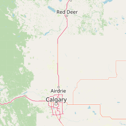
Use this park location map to pinpoint Inglewood Migratory Bird Sanctuary in Canada, understand its exact geographic position, and read its mapped placement within the surrounding landscape more clearly.

Pigeon | © OpenStreetMap contributors

Location context for Inglewood Migratory Bird Sanctuary

Alberta

Visual exploration of riparian forests, floodplain terrain, and urban wildlife habitats

Inglewood Migratory Bird Sanctuary Photos and River Valley Scenery

Examine detailed photos capturing the cottonwood forests, river channels, and protected wildlife habitats defining the sanctuary landscape. Visual records reveal the distinct ecological character of the Bow River valley and its role as an urban conservation refuge.

A sunny day view of a grassy meadow and wetlands surrounded by trees, with a building visible in the distant background.

Park atlas

Compare surrounding regional geography and connected protected landscapes

Parks Near Inglewood Migratory Bird Sanctuary and Related Protected Areas

Browse other parks near Inglewood Migratory Bird Sanctuary to examine similar riparian corridors and urban wildlife refuges across the surrounding region. Extending your geographic comparison helps map broader conservation landscapes and connected natural habitats throughout Alberta.
National parkCanada
About 85 km away#1 closest

West

Banff National Park: Exploring Canada's Iconic National Park Protected Landscape and Geography

Mapped park boundaries and regional geographic context for Banff National Park.

Gain a structured understanding of Banff National Park as a key protected area within Canada. This resource details its identity as a national park, providing insights into its geographic setting and mapped landscape. It serves as a vital point for atlas-based discovery, helping to contextualize Banff National Park's significance within Canada's protected lands and natural terrain.

Area
6,641 km²
Established
1885
IUCN
II
Visitors
4.1M annual
National parkBritish Columbia
About 129 km away#2 closest

West

Kootenay National Park: National Park Protected Landscape and Geographic Context

Explore Kootenay National Park's mapped terrain and regional geography.

Kootenay National Park is a protected national park located in British Columbia, Canada. This dedicated detail page provides an atlas-style exploration of its geographic identity, focusing on its mapped boundaries and the surrounding natural terrain. Understand how Kootenay National Park fits into the larger regional geography, offering rich context for protected landscape discovery and analysis.

Area
1,406 km²
Established
1920
IUCN
II
Visitors
574.1K annual
Wildlife reserveAlberta
About 140 km away#3 closest

North

Red Deer Migratory Bird Sanctuary: Geographic Overview and Protected Wetland Map

Aspen Parkland terrain in central Alberta, Canada

The Red Deer Migratory Bird Sanctuary preserves a key wetland corridor defined by the Gaetz Lakes oxbows. This protected reserve offers a look at the native Aspen Parkland ecoregion, blending shrubland and forest patches that provide essential sanctuary for migratory waterfowl. The mapped area illustrates how this federal reserve maintains a natural landscape mosaic amidst the surrounding urban geography of central Alberta.

Area
1.3 km²
Established
1924
Water
Major water bodies
A horizontal watercolor painting depicting a soft-focus prairie landscape with grasses and rolling hills.
Wildlife reserveAlberta
About 158 km away#4 closest

Northeast

Spiers Lake National Wildlife Area: Mapping Native Grasslands in Central Alberta

A federally managed reserve for rare prairie flora and bird populations.

Located in the County of Stettler, Spiers Lake National Wildlife Area protects one of the remaining fragments of native fescue prairie in Alberta. The reserve provides essential habitat for rare plants and grassland birds, offering a focused look at the original prairie matrix before agricultural conversion. It is a key example of Canadian federal conservation policy preserving vanishing grassland biodiversity.

Area
0.64 km²
Established
1982
IUCN
Ia
Scope
Terrestrial
National parkBritish Columbia
About 161 km away#5 closest

West

Yoho National Park: Mapped Protected Area in British Columbia's Geography

Exploring the park's protected boundaries and terrain.

Yoho National Park is presented here as a distinct national park within British Columbia's vast geographic framework. This page provides a structured view of its protected land status, allowing for detailed exploration of its mapped boundaries and surrounding natural landscapes. Understand Yoho National Park's place in the Canadian atlas through its specific geographic features and protected area context.

Area
1,313 km²
Established
1886
IUCN
II
Visitors
663.9K annual
National parkAlberta
About 203 km away#6 closest

South

Waterton Lakes National Park: Alberta's Protected Landscape and Geographic Atlas

Explore mapped boundaries and regional terrain context.

Waterton Lakes National Park represents a vital protected area situated within the province of Alberta. This atlas view focuses on its mapped boundaries and the characteristic natural terrain, providing essential geographic context for understanding its significance. Discover its role as a national park and its placement within the regional geography of Western Canada, ideal for users seeking structured data on protected lands and landscape features.

Area
505 km²
Established
1895
IUCN
II
Visitors
475.8K annual
National parkMontana
About 226 km away#7 closest

South

Glacier National Park: A Montana National Park with Distinct Protected Landscape Geography

Explore its mapped boundaries and regional natural terrain.

Glacier National Park represents a significant national park entity within Montana, providing a unique lens for understanding protected landscapes and regional geography. As a key component of the US protected areas network, it offers valuable insights into mapped park boundaries and the surrounding natural terrain. This page serves as a gateway to exploring the specific geographic context and landscape identity of Glacier National Park.

Area
4,100.77 km²
Established
1910
IUCN
II
Visitors
2.9M annual
National parkColumbia-Shuswap Regional District
About 226 km away#8 closest

West

Glacier National Park: A National Park within Canada's Protected Landscape Atlas

Explore its mapped boundaries and regional geography.

Glacier National Park represents a significant protected area entity within the broader Canadian geography. This page offers an atlas-oriented perspective on its identity as a national park, focusing on its mapped geographic spread and role as a conservation landscape. Users can explore the park's place within the Columbia-Shuswap Regional District and understand its distinct contribution to the national protected area framework.

Area
1,349 km²
Established
1886
IUCN
II
Visitors
4M annual

Common questions about visiting, size, designation, and location context for Inglewood Migratory Bird Sanctuary

Inglewood Migratory Bird Sanctuary FAQs for park facts, access, geography, and protected area context

Find quick answers about Inglewood Migratory Bird Sanctuary, including protected-area facts, park geography, trail and visitor context, and how the park fits into its surrounding country and regional landscape.
MoriAtlas Explorer

Continue Your Protected Areas Search Across the Global Atlas

Deepen your exploration by continuing the structured search for national parks and protected areas worldwide. Utilize the comprehensive filtering capabilities to compare different conservation landscapes and refine your understanding of global park geography. Discover more about the distribution and characteristics of protected natural areas.

Global natural geography
