Mori Atlas logo
Protected landscapeIronstone Hill Conservation Park

Mapping the sandy dune systems, mallee vegetation, and arid terrain of a critical southern conservation area.

Ironstone Hill Conservation Park: A Protected Landscape Within the Eyre Peninsula of South Australia

Ironstone Hill Conservation Park serves as a protected sanctuary for the endangered Sandhill Dunnart and various native species within the semi-arid environment of the Eyre Peninsula. This reserve encompasses a distinctive landscape of undulating sandy dunes and expansive mallee shrubland. Positioned between the Middleback Range and surrounding agricultural plains, the park functions as a crucial ecological buffer in a region balancing biodiversity conservation with industrial land use.

eyre peninsulasouth australiaconservation parkmalleesandy dunesarid landscape

Ironstone Hill Conservation Park

Protected landscape

Park overview

Structured park overview, official facts, and landscape profile for Ironstone Hill Conservation Park

Ironstone Hill Conservation Park park facts, protected area profile, and essential visitor context

Review the core facts for Ironstone Hill Conservation Park, including designation, size, terrain, visitor scale, habitats, and operating context in one park-focused overview.

About Ironstone Hill Conservation Park

Ironstone Hill Conservation Park is a relatively young but ecologically focused protected area in South Australia, established to conserve an unusual combination of sandy dune systems and mallee shrubland on the western edge of the Middleback Range. Its setting on the Eyre Peninsula places it firmly within the semi-arid climatic zone of southern Australia, where rainfall is low, temperatures can be extreme, and plant and animal communities are highly adapted to harsh, sandy conditions.

The park was proclaimed in August 2010 under the National Parks and Wildlife Act 1972, making it part of South Australia's formal system of conservation reserves. Its size, at roughly 19,650 hectares, gives it meaningful scale for protecting habitat continuity across dune fields and mallee stands. Importantly, its constitution explicitly permits certain land uses under the state's Mining Act 1971 and the Petroleum and Geothermal Energy Act 2000, reflecting the mineral-rich character of the broader Middleback Range region and the ongoing presence of mining operations nearby.

Ecologically, the park stands out for its concentration of sandy dunes, which are the preferred habitat of the Sandhill Dunnart, an endangered species that depends on this relatively uncommon landscape type within South Australia. The surrounding mallee vegetation adds another layer of conservation value, hosting plant species of concern such as the Desert Greenhood orchid and sandalwood. Together, these features make Ironstone Hill Conservation Park a narrow-but-important refuge in a region where land use pressure from mining and pastoral activity is significant.

Quick facts and research context for Ironstone Hill Conservation Park

Ironstone Hill Conservation Park is a Category VI protected area (protected area with sustainable use of natural resources) situated on the Eyre Peninsula in South Australia, around 53 kilometres east south-east of Kimba. It was proclaimed in 2010 under the National Parks and Wildlife Act 1972 and covers roughly 19,650 hectares of sandy dune and mallee vegetation.

The reserve is gazetted within the locality of Middleback Range on the western flank of the Middleback Range landscape, adjacent to the Secret Rocks Nature Reserve private protected area to its west and to mining infrastructure associated with the Iron Duke mine to its east.

Protection and recognition

Explore terrestrial protection metrics and official designation records for Ironstone Hill Conservation Park.

Ironstone Hill Conservation Park Protection Status and Recognition Data

Ironstone Hill Conservation Park maintains a documented terrestrial protection scope without international recognition sources or transboundary borders. Review the recorded management context, official designation parameters, and administrative facts associated with this protected area.

Protection details

Protection scope
Terrestrial
Transboundary protection
No
Park context

Deeper park guide and search-rich context for Ironstone Hill Conservation Park

Ironstone Hill Conservation Park history, landscape, wildlife, and travel context

Explore Ironstone Hill Conservation Park through its history, landscape character, ecosystems, wildlife, conservation priorities, cultural context, and seasonal travel timing in a structured park guide built for atlas discovery and search intent.

Why Ironstone Hill Conservation Park stands out

Ironstone Hill Conservation Park is best known for protecting sandy dune habitats that support the endangered Sandhill Dunnart, one of Australia's rarest small marsupials. These dune systems, combined with extensive mallee vegetation, give the park its distinctive arid-zone ecological character and its specific conservation significance within the Eyre Peninsula.

Ironstone Hill Conservation Park history and protected-area timeline

Ironstone Hill Conservation Park was proclaimed on 26 August 2010 under South Australia's National Parks and Wildlife Act 1972, bringing a substantial area of sandy dune and mallee landscape on the Eyre Peninsula into the state's formal conservation estate. The park was gazetted within the locality of Middleback Range, on the western side of the Middleback Range, an area long associated with iron ore mining rather than nature conservation.

The park was constituted in a way that explicitly recognises the mineral and petroleum potential of the surrounding region, allowing access under the state's Mining Act 1971 and the Petroleum and Geothermal Energy Act 2000. Its location close to the Iron Duke mine, operated by Arrium, places it within a broader industrial landscape where conservation and resource extraction coexist under the same legislative framework.

In 2014, the park was specifically described in conservation assessments as being particularly significant for the protection of sandy dunes and the species they support, reinforcing the central role of habitat conservation in the park's purpose from its earliest years of existence.

Ironstone Hill Conservation Park landscape and geographic character

The landscape of Ironstone Hill Conservation Park is defined by a broad sweep of sandy dune systems set within the semi-arid environment of the Eyre Peninsula. These dunes form the park's most distinctive topographic feature, creating undulating terrain of light-coloured sands that contrast with the harder, rockier country of the Middleback Range immediately to the east. The neighbouring Iron Duke mine's waste-rock dump visually marks the boundary between the park's natural dune system and the heavily modified mining landscape beyond its eastern edge.

To the west, the park adjoins the Secret Rocks Nature Reserve, a private protected area that adds to the unbroken natural character of the region. The wider setting sits between roughly 53 kilometres from the agricultural service town of Kimba and the iron-rich ranges further inland, placing the park in a transitional zone between the farming plains of central Eyre Peninsula and the mineral-bearing uplands of the Middleback Range.

The combination of dune topography, sandy soils, and a low-rainfall climate defines the park's surface character and shapes both its vegetation and the wildlife patterns that the reserve is designed to protect.

Ironstone Hill Conservation Park ecosystems, habitats, and plant life

Vegetation across Ironstone Hill Conservation Park is dominated by mallee, a form of multi-stemmed eucalyptus shrubland that thrives in the dry sandy soils of southern Australia. This mallee cover gives the park its characteristic layered structure of woody shrubs, small eucalypt trees, and ground-level plants adapted to low rainfall and nutrient-poor substrates.

The sandy dunes within the park support a distinct set of plant communities, including populations of the Desert Greenhood, an orchid species, and Sandalwood, both listed as vulnerable under South Australia's National Parks and Wildlife Act. Their presence underscores the conservation value of the park's dune habitats, which provide refuge for plant species that struggle to survive in more disturbed or agricultural landscapes nearby.

Ecologically, the park functions as a relatively intact patch of mallee-dune mosaic within a regional landscape heavily influenced by grazing, mining, and infrastructure development, offering vegetation communities that retain much of their natural composition and structure.

Ironstone Hill Conservation Park wildlife and species highlights

Ironstone Hill Conservation Park is particularly significant for the protection of the Sandhill Dunnart, a small insectivorous marsupial listed as endangered and strongly associated with sandy dune habitats. The park's dunes provide the kind of spinifex-covered, unstable sand country that this species depends on, making the reserve a key refuge for the dunnart in South Australia.

Beyond this headline species, the park's mallee vegetation and dune systems support a broader arid-zone fauna, including small mammals, reptiles, and birdlife typical of semi-arid Eyre Peninsula shrublands. Although detailed species inventories are limited, the combination of intact mallee stands, sandy substrate, and limited disturbance makes the area a useful refuge for wildlife that has declined elsewhere in the region due to land clearing and feral animal impacts.

Ironstone Hill Conservation Park conservation status and protection priorities

The conservation significance of Ironstone Hill Conservation Park centres on its role in protecting sandy dune habitat for the endangered Sandhill Dunnart and on its representation of mallee vegetation in generally good condition. By safeguarding these two interrelated ecological features, the park contributes to the persistence of species and habitats that are increasingly rare across the heavily modified Eyre Peninsula.

Its IUCN Category VI designation as a protected area with sustainable use of natural resources acknowledges that some extractive activities may continue within its boundaries, a recognition of the area's location adjacent to working iron ore mines. Despite this, the park's proclamation under the National Parks and Wildlife Act 1972 gives it formal protection, and its listing of vulnerable plant species such as the Desert Greenhood and sandalwood adds regulatory weight to its conservation role.

In the broader regional context, Ironstone Hill forms part of a network of public and private protected areas, including the adjacent Secret Rocks Nature Reserve, that together help maintain ecological connectivity in a landscape otherwise shaped by agriculture and mining.

Top sights and standout views in Ironstone Hill Conservation Park

Ironstone Hill Conservation Park's standout qualities include its extensive sandy dune habitat, its large remaining tracts of mallee vegetation, and its formal protection of species such as the Sandhill Dunnart, the Desert Greenhood, and sandalwood. Its position between a private nature reserve and an active iron ore mine gives it a distinctive role as a pocket of intact natural landscape within an otherwise heavily developed regional setting.
Monthly climate preview

Long-term monthly temperature and precipitation patterns across representative park terrain

Ironstone Hill Conservation Park Climate Normals and Annual Temperature Rhythm

Ironstone Hill Conservation Park records historical weather variations through sustained monthly temperature ranges and measured daily precipitation averages. Examining the complete twelve-month climate profile reveals broader thermal trends across the protected landscape.
Annual mean18 °C
10 °C25 °C
Jan25°
Feb25°
Mar22°
Apr18°
May14°
Jun11°
Jul10°
Aug11°
Sep14°
Oct17°
Nov21°
Dec23°
Warmest month
January

25 °C

Coolest month
July

10.2 °C

Wettest month
June

1 mm/day

Driest month
March

0.4 mm/day

Park location guide

Geography guide, regional context, and park location map for Ironstone Hill Conservation Park

Ironstone Hill Conservation Park park geography, regions, and map view in Australia

Understand where Ironstone Hill Conservation Park sits in Australia through a broader geographic reading of the surrounding landscape, nearby location context, and its mapped position within the national park landscape.

How Ironstone Hill Conservation Park fits into Australia

Australia is a constitutional monarchy and federal parliamentary democracy comprising six states and ten territories. With a population of nearly 28 million, it is one of the world's most urbanised countries, with most people concentrated on the eastern seaboard. The country has a high Human Development Index and is known for its cultural diversity, ancient Aboriginal heritage, and unique wildlife.

Wider geography shaping Ironstone Hill Conservation Park in Australia

Australia occupies the entire Australian continent, the island of Tasmania, and numerous smaller islands. It is the world's flattest and driest inhabited continent, featuring vast deserts in the interior (the Outback), tropical rainforests along the eastern coast, and a coastline bordering the Indian and Pacific Oceans.

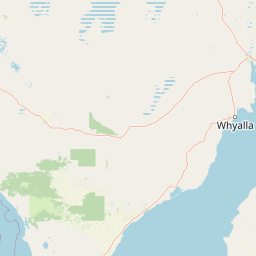
Map view of Ironstone Hill Conservation Park

Use this park location map to pinpoint Ironstone Hill Conservation Park in Australia, understand its exact geographic position, and read its mapped placement within the surrounding landscape more clearly.

Pigeon | © OpenStreetMap contributors

Location context for Ironstone Hill Conservation Park

South Australia
Park atlas

Compare surrounding sandy dunes, mallee shrublands, and regional conservation reserves

Other Parks Near Ironstone Hill Conservation Park and Regional Protected Areas

Browsing other parks near Ironstone Hill Conservation Park reveals connected mallee shrublands and protected sandy dune systems across the Eyre Peninsula. Extending geographic comparison across surrounding conservation reserves uncovers the wider arid landscape patterns of southern Australia.
Wildlife reserveSouth Australia
About 50 km away#1 closest

West

Heggaton Conservation Park: A Protected Wildlife Reserve on the Eyre Peninsula

Mapping the semi-arid mallee woodlands of South Australia

Heggaton Conservation Park is a key wildlife reserve in South Australia that safeguards extensive mallee forest and Melaleuca shrubland. This protected area provides an essential, relatively undisturbed habitat for Malleefowl and various rare plant species within the broader Eyre Peninsula landscape.

Area
64.76 km²
Established
1993
IUCN
VI
Relief
Lowland
A horizontal watercolor illustration of a coastal landscape with pale pink water, green marshy shorelines, and distant soft blue hills against a white background.
Nature reserveSouth Australia
About 51 km away#2 closest

South

Franklin Harbor Conservation Park: Coastal Nature Reserve and Eyre Peninsula Protected Geography

Coastal conservation park and island habitat system in South Australia

This nature reserve protects rare mangrove and samphire flat associations along the eastern coast of the Eyre Peninsula. The geography encompasses a sheltered peninsula and four islands within the harbor, forming an essential maritime habitat for seabirds and reptiles in the South Australian coastal landscape.

Area
13.56 km²
Established
1976
IUCN
Ia
Relief
Lowland
Nature reserveSouth Australia
About 75 km away#3 closest

West

Carappee Hill Conservation Park: Atlas and Geographic Protected Area Profile

Nature reserve geography and Eyre Peninsula landscape context

Carappee Hill Conservation Park covers 8.5 square kilometres of rocky, elevated terrain in the locality of Darke Peak. As a designated conservation area and IUCN Category III site, it serves as a critical refuge for native vegetation, providing a clear map of protected landform heritage in central South Australia.

Area
8.5 km²
Established
1973
IUCN
III
Relief
Upland
A pale, abstract watercolor painting showing rolling green hills, trees, and a light sky against a white background.
Nature reserveSouth Australia
About 75 km away#4 closest

West

Caralue Bluff Conservation Park: A Protected Nature Reserve on the Eyre Peninsula

Mapping regional landscape integrity in South Australia

Caralue Bluff Conservation Park encompasses a 21.5 square kilometre tract of land in South Australia, acting as a crucial element of the Eyre Peninsula landscape. Named for the nearby Caralue Bluff landform, this nature reserve safeguards essential bushland habitats within a highly developed rural setting. Analyze the park boundaries and terrain characteristics to better appreciate its function as a conserved natural refuge.

Area
21.57 km²
Established
1993
IUCN
VI
Scope
Terrestrial
Wildlife reserveSouth Australia
About 82 km away#5 closest

West

Darke Range Conservation Park: A Protected Woodland Sanctuary in South Australia

Geographic landscape and regional habitat exploration

Located near Darke Peak, this wildlife reserve safeguards threatened native peppermint gum woodland. The park functions as an ecologically significant pocket of intact vegetation, providing a window into the natural ridge terrain of the Eyre Peninsula that remains distinct from the surrounding rural land.

Area
6.93 km²
Established
1985
IUCN
VI
Relief
Mountain
Wildlife reserveSouth Australia
About 93 km away#6 closest

Southeast

Bird Islands Conservation Park: A Protected Coastal Landscape in South Australia

Key wildlife reserve on the Spencer Gulf coastline

Bird Islands Conservation Park represents a vital coastal habitat within South Australia. Covering islands and mainland sections near Wallaroo, the area integrates sand dunes, intertidal flats, and mangrove woodlands. This conservation site provides essential refuge for migratory shorebirds while maintaining a complex link between marine and terrestrial ecosystems on the Yorke Peninsula.

Area
3.69 km²
Established
1968
IUCN
VI
Relief
Lowland
National parkSouth Australia
About 100 km away#7 closest

Northeast

Mount Remarkable National Park: Protected Landscape Atlas and South Australia Geography

Explore mapped boundaries and natural terrain.

Mount Remarkable National Park serves as a vital protected area within South Australia's unique geographic setting. This MoriAtlas entry details the park's mapped boundaries and surrounding natural terrain, providing structured insight into its landscape character and regional geographic importance. Understand the park as a key element of Australia's protected lands atlas.

Area
166.18 km²
Established
1972
IUCN
VI
Visitors
50K annual
Natural monumentSouth Australia
About 100 km away#8 closest

East

Clements Gap Conservation Park: A South Australian Natural Monument and Cultural Landscape

Mapping bushland corridors and historic heritage in the Mid North region.

Clements Gap Conservation Park occupies a 7.9 square kilometre footprint, offering a glimpse into the natural terrain of the Mid North region. The area functions as a protected monument that preserves native bushland alongside the built traces of a historic township, showcasing the layered human and environmental geography characteristic of the Spencer Gulf hinterland.

Area
7.9 km²
Established
1963
IUCN
III
Relief
Upland

Common questions about visiting, size, designation, and location context for Ironstone Hill Conservation Park

Ironstone Hill Conservation Park FAQs for park facts, access, geography, and protected area context

Find quick answers about Ironstone Hill Conservation Park, including protected-area facts, park geography, trail and visitor context, and how the park fits into its surrounding country and regional landscape.
MoriAtlas Explorer

Continue Your Protected Areas Search Across the Global Atlas

Deepen your exploration by continuing the structured search for national parks and protected areas worldwide. Utilize the comprehensive filtering capabilities to compare different conservation landscapes and refine your understanding of global park geography. Discover more about the distribution and characteristics of protected natural areas.

Global natural geography