

Mori Atlas logo
National parkIsalo National Park

Discover Madagascar's unique sandstone canyons, endemic tapia woodlands, and mapped terrain.

Isalo National Park: Protected Landscape and Geographic Atlas in Ihorombe Region

Isalo National Park in the Ihorombe Region of Madagascar stands as a striking protected landscape defined by its ancient sandstone formations, deep canyons, and iconic runiform mountains. This national park offers a unique geographic vista, showcasing eroded Triassic to Jurassic sedimentary rocks sculpted by wind and water. With permanent rivers carving through the terrain and exceptional plant endemism, Isalo National Park presents a compelling destination for atlas-driven exploration of Madagascar's distinct natural heritage and mapped natural terrain.

sandstone canyonsendemic tapia woodlandslemursMadagascar dry deciduous forestsgeological formationsnational park

Isalo National Park

National park

Park overview

Structured park overview, official facts, and landscape profile for Isalo National Park

Isalo National Park park facts, protected area profile, and essential visitor context

Review the core facts for Isalo National Park, including designation, size, terrain, visitor scale, habitats, and operating context in one park-focused overview.

About Isalo National Park

Isalo National Park represents one of Madagascar's most ecologically and geologically significant protected areas, showcasing a dramatic landscape shaped by millions of years of erosional processes. The park's sandstone formations, part of the Isalo Group geological formation reaching up to 6,000 meters in thickness, create an otherworldly terrain of towering cliffs, narrow canyons, and peculiar rock shapes that attract both scientific interest and visitor wonder. Beyond its geological importance, Isalo serves as a critical refuge for Madagascar's endemic biodiversity, protecting portions of both the dry deciduous forests and subhumid forests ecoregions in an island where natural vegetation has been dramatically reduced. The park's location in the arid western portion of Madagascar places it at the intersection of multiple ecological zones, creating a mosaic of habitats from sclerophyllous tapia woodlands on the slopes to lush evergreen forests along permanent watercourses in the deep canyons. This habitat diversity supports remarkable species richness, with numerous narrowly endemic plants and animals depending on the protected landscapes that Isalo maintains.

Quick facts and research context for Isalo National Park

Isalo National Park is located in southwestern Madagascar's Ihorombe Region, with the nearest town being Ranohira and the closest cities being Toliara and Ihosy. The park protects a sandstone landscape featuring canyons up to 200 meters deep, plateaus, and eroded rock formations. It falls within the dry deciduous forests ecoregion and includes patches of subhumid forest in canyon bottoms. The area experiences a hot, dry climate with two distinct seasons, with average temperatures around 21.8°C and annual rainfall of approximately 791mm. The park is administered by Madagascar National Parks Association and receives approximately 32,000 visitors annually.

Protection and recognition

Exploring the documented land management scope and official global conservation database records.

Isalo National Park Protection Status and Terrestrial Conservation Frame

Map the terrestrial boundaries and protection framework of Isalo National Park to understand its official designation as a safeguarded inland landscape. Verifying documented conservation records and global database entries helps clarify the formal management status of Madagascar's protected terrestrial landscapes.

Protection details

Protection scope
Terrestrial
Transboundary protection
No
Park context

Deeper park guide and search-rich context for Isalo National Park

Isalo National Park history, landscape, wildlife, and travel context

Explore Isalo National Park through its history, landscape character, ecosystems, wildlife, conservation priorities, cultural context, and seasonal travel timing in a structured park guide built for atlas discovery and search intent.

Why Isalo National Park stands out

Isalo is best known for its dramatic sandstone landscape of deep canyons, eroded rock domes, and the distinctive runiform mountains that give the area its iconic appearance. The park protects some of the largest intact areas of tapia woodlands (Uapaca bojeri) in Madagascar, a woodland type restricted to the island's central highlands. The park is also renowned for its exceptional plant endemism, with 13 plant species found nowhere else on Earth, including two species in the endemic Sarcolaenaceae family. The natural swimming pools carved into the sandstone provide memorable visitor experiences, while the presence of multiple lemur species including ring-tailed lemurs, Verreaux's sifaka, and red-fronted lemurs adds to the park's wildlife significance.

Isalo National Park history and protected-area timeline

Isalo National Park was established in 1962, making it one of Madagascar's older protected areas. The park has been administered by Madagascar National Parks Association (PNM-ANGAP) since 1997, bringing professional conservation management to the region. The Bara people have traditionally inhabited this area, maintaining a nomadic pastoralist lifestyle centered on zebu cattle farming. Their cultural presence is evidenced by burial sites throughout the park, with some older burial sites associated with the Sakalava people. Archaeological research at a site called Teniky in 2024 documented man-made rock-cut niches dating to the tenth to twelfth centuries CE, with possible Zoroastrian provenance, adding a layer of human history to the geological wonders of the landscape. The park's creation protected an area of exceptional ecological and geological significance that had long been inhabited and utilized by local communities.

Isalo National Park landscape and geographic character

The physical landscape of Isalo National Park is dominated by the Isalo Massif, a massive sandstone formation that has been sculpted into one of Madagascar's most visually striking terrains. The sedimentary rocks, deposited by braided streams during the Triassic to early Jurassic period, have been eroded by wind and water into a remarkable variety of landforms. Deep canyons cut up to 200 meters into the sandstone, creating narrow passages with towering walls. Flat-topped mountains and sandstone domes rise above the surrounding plains, while the distinctive runiform mountains feature steep-sided outcrops dissected into odd, almost sculptural shapes. Permanent rivers and streams flow through the canyon floors, providing permanent water in an otherwise arid landscape, while numerous seasonal watercourses respond to the wet season rains. The elevation range from 510 to 1,268 meters creates subtle but meaningful changes in the visual character of the landscape as visitors move through the park.

Isalo National Park ecosystems, habitats, and plant life

Isalo National Park encompasses remarkable ecological diversity through its six distinct habitat types. The sclerophyllous tapia woodlands represent some of the largest intact areas of this endemic-dominated forest type in Madagascar, with the tapia tree (Uapaca bojeri) forming an open canopy adapted to the regular burning that characterizes the region. Deep canyon ravines support evergreen humid forests with palm species, Breonadia salicina, and other moisture-loving plants. Pandanus thickets occur in degraded valley areas, while dry rocky slopes host specialized xerophytic vegetation including the elephant's foot plant (Pachypodium rosulatum) and endemic Aloe species. Secondary shrub communities and expansive grasslands complete the habitat mosaic, with the grasslands having expanded significantly as a result of historical fire regimes intended to facilitate cattle grazing. The park spans both the dry deciduous forests ecoregion, which has lost nearly 40% of its original extent, and patches of the critically endangered subhumid forests ecoregion.

Isalo National Park wildlife and species highlights

Isalo supports a diverse fauna including 14 mammal species, over 100 bird species, 24 amphibians, and 47 reptiles. The park is particularly notable for its lemur populations, with daytime species including the iconic ring-tailed lemur (Lemur catta), Verreaux's sifaka (Propithecus verreauxi), and red-fronted lemur (Eulemur rufifrons). Night-active lemurs include the gray mouse lemur (Microcebus murinus), red-tailed sportive lemur (Lepilemur ruficaudatus), and Coquerel's giant mouse lemur (Mirza coquereli). Over 100 bird species have been documented, including Benson's rock thrush (Monticola sharpei bensoni), the knob-billed duck (Sarkidiornis melanotos), and the Madagascar ibis (Lophotibis cristata). The reptile fauna includes the Madagascar ground boa and Dumeril's boa, while amphibians include the colorful Malagasy rainbow frog (Scaphiophryne gottlebei) and several endemic Mantella species. Several species are endemic specifically to the Isalo region, including four amphibians and one reptile species.

Isalo National Park conservation status and protection priorities

Isalo National Park plays a critical conservation role in Madagascar by protecting portions of two globally significant ecoregions. The dry deciduous forests, which cover most of the park, have lost nearly 40% of their original extent across Madagascar, making protected areas like Isalo essential for maintaining viable populations of endemic species. The subhumid forest patches within the park represent an even more imperiled habitat, classified as Critical/Endangered due to severe fragmentation and small remaining area. The park's exceptional plant endemism, with 13 species found only in Isalo and another 35 species known from just 2-5 sites globally, underscores its irreplaceable conservation value. The Sarcolaenaceae family, entirely endemic to Madagascar, is represented in Isalo by two species found nowhere else. However, the park faces significant threats from illegal wildfires set primarily to maintain grasslands for cattle grazing, which limits forest extent and degrades habitat quality.

Isalo National Park cultural meaning and human context

Thebara people have traditionally inhabited the Isalo region, maintaining a nomadic pastoralist lifestyle centered on zebu cattle farming. Their presence in the landscape is evidenced by burial sites throughout the park, indicating long-term cultural connection to this terrain. Older burial sites associated with the Sakalava people suggest even earlier human presence in the area. Archaeological investigations at the Teniky site revealed rock-cut niches dating to the tenth through twelfth centuries CE, potentially representing Zoroastrian religious practice and adding prehistoric human dimension to the landscape. The ongoing traditional use of the landscape by the Bara people creates both cultural continuity and management challenges, as cattle grazing practices interact with fire regimes and habitat conservation objectives.

Top sights and standout views in Isalo National Park

The dramatic sandstone canyons and eroded rock formations of Isalo Massif represent the park's most visually striking feature, with deep gorges, towering domes, and the distinctive runiform mountains creating an almost lunar landscape. The natural swimming pools carved into the sandstone provide memorable visitor experiences in the arid environment. The park protects exceptional plant endemism, with some of the largest intact tapia woodlands in Madagascar and 13 plant species found nowhere else on Earth. Multiple lemur species can be observed, including the iconic ring-tailed lemur and Verreaux's sifaka, making Isalo an excellent location for primate viewing. The cultural heritage of the Bara people, evident in burial sites throughout the park, adds human dimension to the geological wonders.

Best time to visit Isalo National Park

The best time to visit Isalo National Park is during the cooler, drier season which typically runs from May through October, when temperatures are more comfortable for trekking and the risk of wildfires is reduced. The warmer, wetter season from November through April brings higher temperatures and rainfall, with January typically being the wettest month. However, the wet season can see dramatic variations, as demonstrated in the 2018/2019 season when 526mm of rain fell in January alone compared to the average of 199mm. Visitors during the wet season may encounter lush green landscapes and fuller watercourses, though some trails may be more challenging. The natural swimming pools are popular year-round, though water levels and accessibility can vary with seasonal conditions. Trekking is possible throughout the year, though guides are required for all park visitors.
Monthly climate preview

Analyzing long term temperature and precipitation trends across the Ihorombe Region

Isalo National Park Climate Normals and Monthly Weather Averages

Long-term meteorological records at an elevation of 868 meters reveal a distinct cycle of warm wet periods and cooler dry phases within Isalo National Park. Accessing the complete monthly database helps researchers trace precise temperature shifts and precipitation variations across the protected landscape of the Ihorombe Region.
Annual mean20 °C
16 °C24 °C
Jan23°
Feb23°
Mar22°
Apr20°
May18°
Jun16°
Jul16°
Aug17°
Sep20°
Oct22°
Nov24°
Dec24°
Warmest month
December

24 °C

Coolest month
July

15.5 °C

Wettest month
January

8.7 mm/day

Driest month
August

0.3 mm/day

Park location guide

Geography guide, regional context, and park location map for Isalo National Park

Isalo National Park park geography, regions, and map view in Madagascar

Understand where Isalo National Park sits in Madagascar through a broader geographic reading of the surrounding landscape, nearby location context, and its mapped position within the national park landscape.

How Isalo National Park fits into Madagascar

Madagascar is an island nation in the Indian Ocean, positioned off the southeastern coast of Africa. As the world's fourth-largest island and second-largest island country, it stands out for its exceptional biodiversity, over 90% of its wildlife is endemic, making it one of 17 megadiverse countries. The population is approximately 32 million, with Antananarivo as both the capital and largest city.

Wider geography shaping Isalo National Park in Madagascar

Madagascar lies in the Indian Ocean off the southeastern coast of Africa, separated from the mainland by the Mozambique Channel. The island is situated approximately 400 km from the African continent. As the world's fourth-largest island, it also includes numerous smaller peripheral islands.

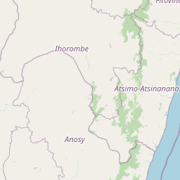
Map view of Isalo National Park

Use this park location map to pinpoint Isalo National Park in Madagascar, understand its exact geographic position, and read its mapped placement within the surrounding landscape more clearly.

Pigeon | © OpenStreetMap contributors

Location context for Isalo National Park

Ihorombe Region
Park atlas

Explore the diverse regional geography and unique protected landscapes surrounding Isalo's dramatic sandstone massif.

National Parks and Protected Areas Near Isalo National Park, Madagascar

Continue your discovery of Madagascar's protected areas by exploring national parks and other reserves situated geographically adjacent to Isalo National Park. This atlas view allows for comparison of varied ecosystems, from sandstone canyons to unique dry deciduous forests, providing a broader context for conservation landscapes across the Ihorombe Region.
National parkAtsimo-Andrefana
About 55 km away#1 closest

Southwest

Zombitse-Vohibasia National Park: Protected Landscape and Regional Geographic Context

Mapped protected areas and natural terrain discovery.

Investigate Zombitse-Vohibasia National Park, a designated national park within the Atsimo-Andrefana region. This dedicated entry provides detailed geographic information, focusing on the park's mapped terrain and its contribution to the regional protected landscape. Gain insight into the park's atlas-relevant features and its specific place within Madagascar's conservation geography.

Area
363.08 km²
Established
2002
IUCN
II
Relief
Upland
Natural monumentAtsimo-Andrefana
About 103 km away#2 closest

West

Analavelona Natural Monument: An Isolated Montane Forest Refuge in Southwestern Madagascar

Mapping a sacred and biodiverse massif in the Atsimo-Andrefana region

Analavelona Natural Monument represents a striking geographic contrast, standing as an elevated montane forest massif surrounded by arid plains. This protected landscape contains a complex ecological mosaic, ranging from humid evergreen forests to rocky sclerophyllous slopes. Recognized for its sacred status and high level of narrow-range endemism, the massif serves as an essential ecological island within the broader topography of southwestern Madagascar.

Area
44.87 km²
Established
2015
Relief
Mountain
Climate
Tropical
Wildlife reserveAtsimo-Andrefana
About 126 km away#3 closest

Southwest

Beza Mahafaly Special Reserve: Atlas of the Gallery Forest and Dry Bush Landscape

Protected riparian ecosystems in the Atsimo-Andrefana region

Beza Mahafaly Special Reserve provides a concentrated look at Madagascar's rare gallery forest ecosystems. Situated within the dry, thorny spiny bush of the Atsimo-Andrefana region, the reserve protects a unique linear woodland environment. Its geography is characterized by the striking contrast between river-fed riparian corridors and the arid, undulating terrain that defines the southwestern landscape.

Area
6 km²
Established
1986
IUCN
IV
Wildlife reserveMadagascar
About 147 km away#4 closest

Southeast

Kalambatritra Special Reserve: Exploring the Geography of Southern Madagascar Protected Lands

Mapping a unique humid highland forest refuge

The Kalambatritra Special Reserve comprises a significant forested block in southern Madagascar, defined by ridges and valleys that maintain a humid microclimate. This protected area serves as a critical habitat for endemic wildlife, bridging the gap between eastern forest ecosystems and the drier terrain of the southern plateau, providing an essential study in island geography and conservation.

Area
282.55 km²
Established
1959
IUCN
IV
Scope
Terrestrial
National parkHaute Matsiatra
149 km away#5 closest

East

Andringitra National Park: A Protected Landscape within Haute Matsiatra's Geography

Explore mapped park boundaries and regional terrain.

Andringitra National Park represents a vital protected area within the Haute Matsiatra region, contributing significantly to the mapped landscape of central Madagascar. Its designation as a national park underscores its importance for conservation and geographic study. Users exploring this destination can gain a detailed understanding of its specific protected boundaries, the surrounding natural terrain, and its overall contribution to the regional geography, making it a key site for atlas-based landscape discovery.

Area
311.6 km²
Established
1999
IUCN
II
Visitors
3.4K annual
Wildlife reserveIhorombe
About 163 km away#6 closest

East

Réserve spéciale du Pic d'Ivohibe: Protected Wildlife Reserve in the Ihorombe Region

A rugged mountain massif and vital watershed landscape

Located in the Ihorombe region, Réserve spéciale du Pic d'Ivohibe protects the southern section of the Andringitra mountain chain. The reserve acts as a vital condensation-driven microclimate, supporting lush evergreen forests and rupicolous highland vegetation. This protected area serves as an essential water source for local river systems while harboring a documented diversity of endemic plants and southeast-restricted lemur populations.

Area
34.53 km²
Established
1964
IUCN
Ia
Relief
Mountain
National parkAtsimo-Atsinanana
About 186 km away#7 closest

Southeast

Midongy du sud National Park: National Park in Atsimo-Atsinanana, Madagascar

Explore its protected landscape and mapped geography.

Midongy du sud National Park is a significant protected area located in the Atsimo-Atsinanana region of Madagascar. This entry provides detailed geographic context, focusing on the park's mapped boundaries and its identity as a national park. It supports atlas-based discovery by offering insights into the park's specific landscape and its regional setting within southeastern Madagascar, serving as a factual resource for understanding its protected status.

Area
1,922 km²
Established
1997
IUCN
II
Relief
Mountain
Nature reserveToliara Province
About 191 km away#8 closest

Northwest

Kirindy Forest Nature Reserve: Protected Dry Deciduous Forest in Western Madagascar

Geography, protected boundaries, and unique dry forest ecosystems

Kirindy Forest offers a detailed look into the ecology of western Madagascar. As a protected nature reserve, it shelters three species of baobab trees and diverse primate populations. Its terrain ranges from flat to gently undulating, creating a distinct visual rhythm through alternating dry and rainy seasons within the Menabe region.

Area
125 km²
Relief
Lowland
Climate
Tropical
Access
Moderate access

Common questions about visiting, size, designation, and location context for Isalo National Park

Isalo National Park FAQs for park facts, access, geography, and protected area context

Find quick answers about Isalo National Park, including protected-area facts, park geography, trail and visitor context, and how the park fits into its surrounding country and regional landscape.
MoriAtlas Explorer

Continue Your Protected Areas Search Across the Global Atlas

Deepen your exploration by continuing the structured search for national parks and protected areas worldwide. Utilize the comprehensive filtering capabilities to compare different conservation landscapes and refine your understanding of global park geography. Discover more about the distribution and characteristics of protected natural areas.

Global natural geography