
Mori Atlas logo
National parkIsla de Flores

Trace the shifting boundaries and tidal terrain of this historic Río de la Plata island.

Isla de Flores National Park: Exploring the Geography and Protected Maritime Landscape of Uruguay

(Parque Nacional Isla de Flores)

Isla de Flores National Park occupies a critical geographic position in the Río de la Plata, serving as a protected maritime sanctuary off the coast of Canelones Department. This low-lying island landscape, which fragments into three distinct islets at high tide, encompasses a significant maritime buffer zone and a complex history of colonial navigation. Analyze the island's unique estuarine terrain and its role as a preserved cultural and natural landmark within Uruguay's protected system.

islandestuarynational parkprotected areacoastal landscapemaritime heritage
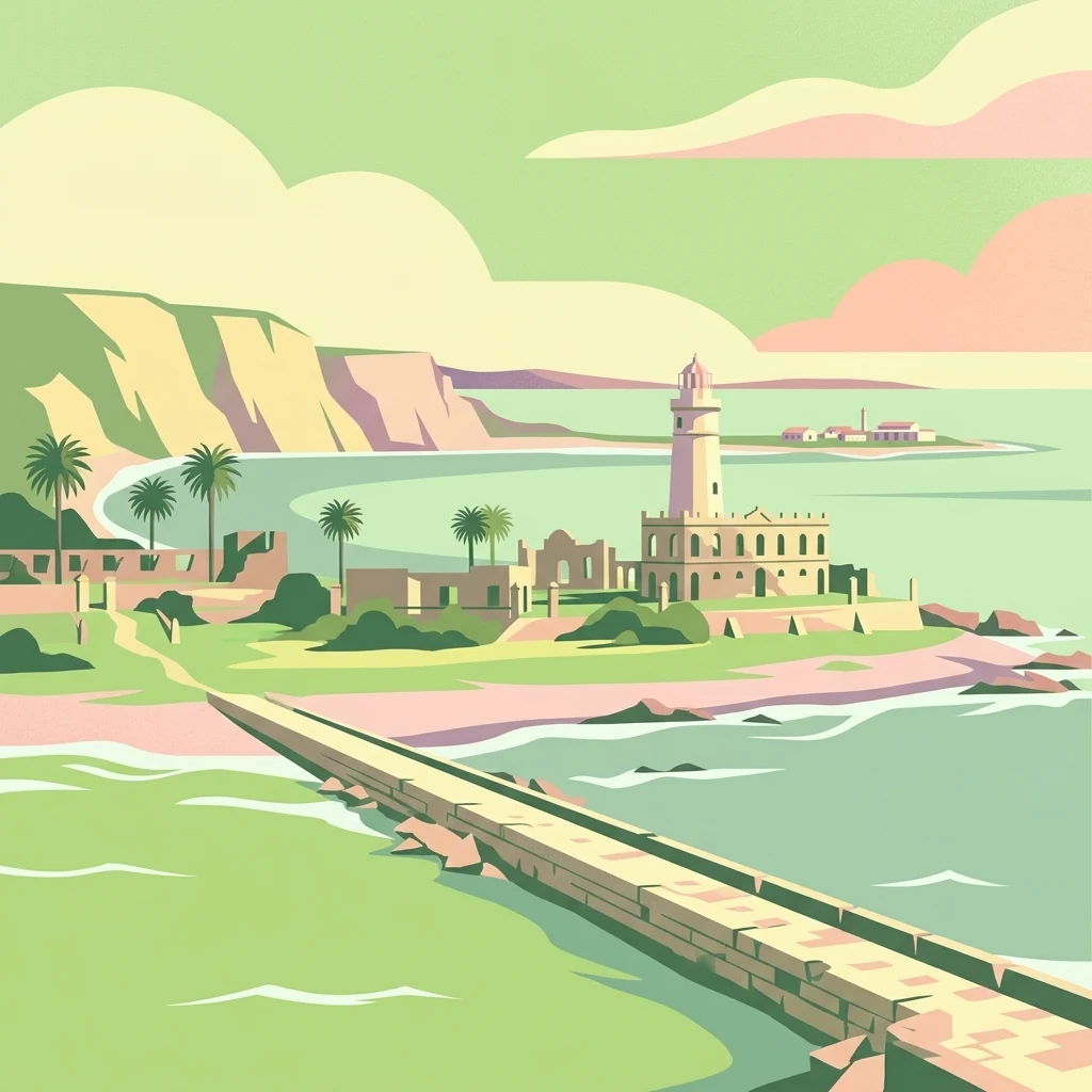
Stylized vector-style illustration of a coastal island park with a prominent lighthouse, stone ruins, palm trees, and a pier extending into the water.

Isla de Flores

National park

Park overview

Structured park overview, official facts, and landscape profile for Isla de Flores

Isla de Flores park facts, protected area profile, and essential visitor context

Review the core facts for Isla de Flores, including designation, size, terrain, visitor scale, habitats, and operating context in one park-focused overview.

About Isla de Flores

Isla de Flores occupies a distinctive niche in Uruguay's protected-area network as both a natural site and a layered cultural landscape. Although the island is tiny by any continental measure, its position in the Río de la Plata, its long history of human use, and the survival of structures such as the historic lighthouse and the lazaretto complex have made it a focus of conservation, heritage, and research activity.

As a national park, Isla de Flores represents one of Uruguay's more recent additions to its formal protected-area system, having been declared part of the Sistema Nacional de Áreas Protegidas in 2018 under the name Parque Nacional Isla de Flores. The designation covers both the island itself and a buffer of two nautical miles of surrounding water, recognizing the inseparable link between the small landmass and its maritime environment in the Río de la Plata. The island's low elevation, modest size, and tidal fragmentation during high water have shaped both its ecological character and its historic role as a stepping stone in the estuary.

Beyond its formal protection, Isla de Flores carries an unusually rich cultural and historical dimension. It witnessed some of the earliest European navigation in the region, hosted an immigrant quarantine station that served as a gateway to Uruguay for thousands of arrivals, and contains a lighthouse whose political and diplomatic history stretches back to the country's independence era. The combination of natural setting, maritime context, and built heritage is the basis for the island's 2015 inclusion in Uruguay's Tentative List for UNESCO World Heritage candidacy, treating it as a cultural landscape defined by its fluvial and marine surroundings rather than as a purely natural site.

Quick facts and research context for Isla de Flores

Isla de Flores is a small island of roughly 31 hectares in the Río de la Plata, administered by Uruguay's department of Canelones and protected since 2018 as a national park under the country's National System of Protected Areas. It sits about 21 kilometers southeast of Punta Carretas in Montevideo, between the Uruguayan capital's coastline and the Banco Inglés reef. The island is low-lying, with its highest point only about two meters above sea level, and at high tide it briefly separates into three smaller islets. It carries an unusually dense historical footprint for its size, anchored by a colonial-era lighthouse and the remains of an immigrant lazaretto, and has been listed since 2015 on Uruguay's Tentative List for UNESCO World Heritage recognition.

Protection and recognition

Documented conservation scope, designation year, and international recognition details

Isla de Flores Protection Status and Official Designation History

Isla de Flores maintains a documented mixed protection status established in the year 2018 with no imported international recognition sources recorded. Official designation records outline the regulatory management framework governing this protected area within conservation databases.

Protection details

Protection scope
Mixed
Designated year
2018
Transboundary protection
No
Park context

Deeper park guide and search-rich context for Isla de Flores

Isla de Flores history, landscape, wildlife, and travel context

Explore Isla de Flores through its history, landscape character, ecosystems, wildlife, conservation priorities, cultural context, and seasonal travel timing in a structured park guide built for atlas discovery and search intent.

Why Isla de Flores stands out

Isla de Flores is best known for its 19th-century lighthouse, the so-called 'most expensive lighthouse in the world,' which was the subject of the 1819 Treaty of the Farola and cost the Banda Oriental the Misiones Orientales. It is also strongly associated with its role as a maritime lazaretto, where arriving immigrants were quarantined and which later served as a prison during periods of Uruguayan political turmoil.
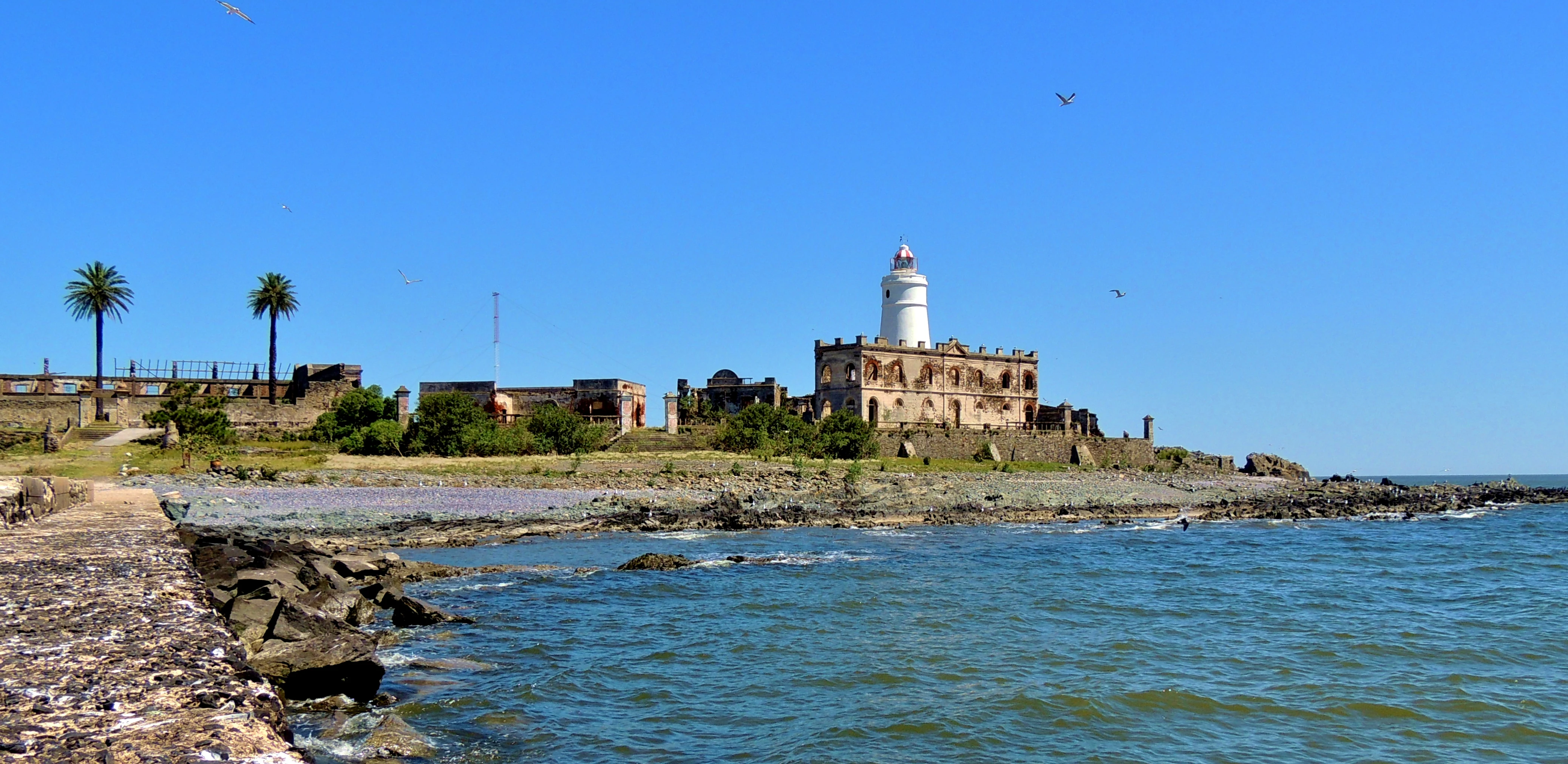
A sunny view of the historic lighthouse and stone ruins on Isla de Flores, surrounded by the Rio de la Plata.
The historic lighthouse and former quarantine station buildings on Isla de Flores.

Isla de Flores history and protected-area timeline

Isla de Flores was named by the explorer Sebastián Caboto, who reached it on Easter Sunday (Pascua Florida) in 1527, giving the island its association with the festival of flowers. From that early moment, the island became a landmark used by navigators entering or leaving the Río de la Plata.

The first formal aid to navigation on the island was installed in 1792, when Spanish colonial authorities placed the stern lantern of the warship Loreto there to serve as a beacon. By 1798 the light had been moved to the Cerro de Montevideo, marking a shift in how the estuary's maritime traffic was directed. In the years that followed, the Portuguese-built lighthouse that still defines the island came into service in 1828. This lighthouse later became central to the 1819 Treaty of the Farola, a diplomatic episode in which the Banda Oriental lost the Misiones Orientales, and earned the popular nickname of 'the most expensive lighthouse in the world.' The lighthouse remains active, standing 37 meters tall and emitting two flashes every ten seconds, and today it is operated by the Lighting and Beaconing Service of Uruguay's National Navy.

In more recent centuries, Isla de Flores became an immigration gateway. An immigrant hotel functioned on the island as a lazaretto enforcing mandatory quarantines, and from 1935 onward the same facilities were repurposed as a prison, including during the dictatorship of Gabriel Terra. The island's heritage value was formally recognized in 2011, when reconstruction work under the Isla de Flores Project was declared of National Interest. In 2012, Uruguay's Ministry of Housing, Territorial Planning, and Environment signed an agreement with the Instituto de Investigaciones Históricas y Sociales del Plata (IIHSP) to design and implement the management and recovery of the island's natural and cultural heritage, and the Lazaretto Museum opened on the first islet in January 2018. On 6 June 2012, an Air Class aircraft disappeared in the waters near the island; its wreckage was located to the southeast on 20 July of that year.

Isla de Flores landscape and geographic character

The physical landscape of Isla de Flores is defined by its small scale, low elevation, and watery setting. The island covers roughly 31 hectares in the Río de la Plata, with its highest point reaching only about 2 meters above sea level. Because of this minimal relief, the surrounding estuary is never far away, and during high tide the island divides into three smaller islets, giving it an ephemeral, shifting character.

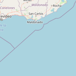
The island lies about 21 kilometers southeast of Punta Carretas in Montevideo, roughly halfway between the city's waterfront rambla and the Banco Inglés, a feared navigational hazard located about 10 nautical miles to the southeast. This position places Isla de Flores in a transitional zone of the Río de la Plata, where coastal waters, estuarine currents, and submerged banks all interact. The terrain itself is flat and tidal, with no significant hills, cliffs, or inland features; the island's profile is essentially a low green swell punctuated by built structures, most prominent among them the 37-meter lighthouse that has served as the island's visual marker since the early 19th century.
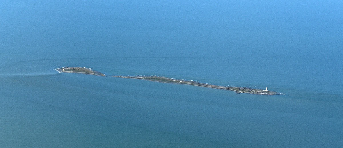
An aerial shot of the long, narrow Isla de Flores surrounded by the deep blue waters of the Rio de la Plata, with a small white lighthouse visible at one end of the island.
Aerial view of Isla de Flores, Uruguay, featuring its historic lighthouse.

Isla de Flores ecosystems, habitats, and plant life

As a protected natural site, Isla de Flores sits within Uruguay's National System of Protected Areas, and the surrounding two nautical miles of water are included along with the island itself in the Parque Nacional Isla de Flores designation established in 2018. The park's ecological identity is closely tied to its position in the Río de la Plata estuary, rather than to any large terrestrial ecosystem.

The extremely low elevation, small surface area, and tidal inundation patterns mean that the island functions more as a maritime and coastal environment than as a forested or mountainous reserve. The protected designation recognizes the inseparable nature of the small landmass and its surrounding waters, and the 2015 Tentative List inscription for UNESCO World Heritage candidacy frames the island specifically as a cultural landscape defined by its fluvial and marine context. This framing highlights the value of the park as an integrated estuary-landscape system rather than as a refuge for large terrestrial biodiversity.

Isla de Flores conservation status and protection priorities

Isla de Flores has been part of Uruguay's formal conservation framework only since 26 February 2018, when the island and a surrounding two-nautical-mile maritime buffer were declared a national park under the country's Sistema Nacional de Áreas Protegidas. This designation was preceded by a heritage-focused step in 2015, when the Cultural Landscape of Isla de Flores and its fluvial-maritime context were placed on Uruguay's Tentative List for UNESCO World Heritage status, framing the park not only as a natural area but as a cultural landscape in close dialogue with the estuary.

The conservation effort that followed has combined natural and cultural recovery. A cooperation agreement signed in 2012 between the Ministry of Housing, Territorial Planning, and Environment and the Instituto de Investigaciones Históricas y Sociales del Plata laid out a strategy to recover both the natural and cultural heritage of the island. A subsequent 2019 agreement with the Ministry of National Defense and the National Navy arranged regular transport of research teams to the island every two weeks, supporting the Isla de Flores Project's ongoing fieldwork, heritage reconstruction, and museum work, including the Lazaretto Museum inaugurated in January 2018.

Isla de Flores cultural meaning and human context

Isla de Flores carries one of Uruguay's richest concentrations of layered cultural history for such a small landmass. The island was named by Sebastián Caboto on Easter Sunday 1527, anchoring it to the very first phase of European exploration of the Río de la Plata. Its 19th-century Portuguese-built lighthouse became a symbol in the region's early post-independence diplomacy, particularly through the 1819 Treaty of the Farola, which cost the Banda Oriental the Misiones Orientales and gave the lighthouse its enduring reputation as 'the most expensive lighthouse in the world.'

The island also played a direct role in shaping Uruguay's identity as a country of immigration. The lazaretto that operated on Isla de Flores enforced mandatory quarantines for arriving immigrants, and later served as a prison, including during the dictatorship of Gabriel Terra from 1935 onward. These built and institutional layers are the reason why the island's cultural landscape was declared of National Interest in 2011 and why the Lazaretto Museum was inaugurated on the first islet in January 2018, giving the island a visible place in Uruguay's ongoing reflection on migration, sovereignty, and heritage.

Top sights and standout views in Isla de Flores

Isla de Flores stands out for the unusual density of historical, navigational, and immigration-related heritage packed into a tiny, low-lying Río de la Plata island, all of which now sits within a formal national park framework. Its defining highlights include the 37-meter historic lighthouse and the surrounding colonial-era maritime story, the surviving lazaretto complex linked to waves of immigration and later political repression, and the protected maritime buffer that ties the island to the estuary environment. Together these features give the park a character that is at once natural, cultural, and deeply tied to Uruguay's national history.

Monthly climate preview

Long-term monthly temperature and precipitation averages for Canelones Department

Isla de Flores Climate Normals and Annual Temperature Rhythm

Historical NASA Power records track measured temperature and precipitation variations across the representative coordinate of Isla de Flores from 1991 to 2020. Examining the full monthly breakdown reveals long-term thermal rhythms and precipitation patterns across the protected landscape.
Annual mean17 °C
11 °C22 °C
Jan22°
Feb22°
Mar21°
Apr18°
May15°
Jun12°
Jul11°
Aug12°
Sep13°
Oct15°
Nov18°
Dec21°
Warmest month
January

22.3 °C

Coolest month
July

10.7 °C

Wettest month
April

4 mm/day

Driest month
August

2.8 mm/day

Park location guide

Geography guide, regional context, and park location map for Isla de Flores

Isla de Flores park geography, regions, and map view in Uruguay

Understand where Isla de Flores sits in Uruguay through a broader geographic reading of the surrounding landscape, nearby location context, and its mapped position within the national park landscape.

How Isla de Flores fits into Uruguay

Uruguay is a unitary presidential republic located in southeastern South America. It covers approximately 176,215 km² and has a population of nearly 3.5 million people. The capital and largest city is Montevideo, where roughly 2 million people live in the metropolitan area. Uruguay gained independence between 1825 and 1828 following territorial disputes involving Portugal, Spain, Brazil, and the United Provinces of the Río de la Plata.

Wider geography shaping Isla de Flores in Uruguay

Uruguay is situated in the southeastern part of South America, bordering Argentina to its west and southwest, Brazil to its north and northeast, the Río de la Plata estuary to the south, and the Atlantic Ocean to the southeast. The terrain consists primarily of rolling plains and low hills, with the highest point being Cerro Catedral at approximately 514 meters. The country has several rivers including the Uruguay River, Paraná River, and Negro River.

Map view of Isla de Flores

Use this park location map to pinpoint Isla de Flores in Uruguay, understand its exact geographic position, and read its mapped placement within the surrounding landscape more clearly.

Pigeon | © OpenStreetMap contributors

Location context for Isla de Flores

Canelones Department

Visual reference guide to the terrain, low-lying coastal environment, and historic architecture of the island park

Isla de Flores Photos, Landscapes, and Protected Estuary Scenery

Visual records capture the low-lying terrain, tidal flats, and maritime architecture defining the protected estuary environment of Isla de Flores. Photographic documentation reveals the scale of the historic lighthouse and surrounding protected landscapes across the Río de la Plata.

A sunny view of the historic lighthouse and stone ruins on Isla de Flores, surrounded by the Rio de la Plata.

An archival black and white photograph showing a complex of low, white stone buildings situated on a flat coastal landscape, with a path leading toward the horizon.

An aerial shot of the long, narrow Isla de Flores surrounded by the deep blue waters of the Rio de la Plata, with a small white lighthouse visible at one end of the island.

Park atlas

Compare regional estuary geography and connected coastal conservation landscapes

Explore Protected Areas and Nearby National Parks Around Isla de Flores

Users examining Isla de Flores can expand their geographic scope by browsing surrounding estuarine reserves and coastal protected areas. Such comparison reveals broader regional patterns in maritime heritage and low-lying estuarine terrain across the coastal zone.
A watercolor painting of a wetland scene showing green, marshy areas and gentle, rolling hills in the background with soft brushwork.
Protected landscapeMontevideo
About 42 km away#1 closest

Northwest

Humedales de Santa Lucía Protected Landscape: Geography and Mapped Wetland Boundaries in Uruguay

A dynamic tidal freshwater system located near the Montevideo riverfront

Humedales de Santa Lucía is a significant protected landscape spanning the departments of San José, Canelones, and Montevideo. This managed wetland ecosystem is defined by the interaction between freshwater river discharge and the brackish tidal influence of the Río de la Plata estuary, creating a unique riparian mosaic of channels, islands, and marshlands important to local waterbird populations.

Area
865.17 km²
Established
2015
Relief
Lowland
Access
Easy access
Watercolor painting showing a hill with green landscape and distant mountains
National parkUruguay
About 95 km away#2 closest

Northeast

Arequita National Park: Uruguay's National Park Protected Landscape and Geography

Mapped boundaries and regional natural terrain context for a key protected area.

Delve into Arequita National Park, a designated national park contributing to Uruguay's protected land inventory. This resource explores the park's unique geographic setting, its mapped boundaries, and its significance within the natural landscape of the Southern Cone. Gain structured insight into its role as a protected area and its contribution to the regional geography of South America.

Scope
Terrestrial
Water
No major water
Watercolor painting of a soft landscape with rolling hills in the background and grassy plains in the foreground on a white background.
National parkLavalleja Department
About 95 km away#3 closest

Northeast

Parque nacional Arequita: Protected Landscape and Volcanic Geography in Lavalleja

Mapped natural terrain and protected ecosystems of southeastern Uruguay.

Parque nacional Arequita preserves a unique volcanic landscape in the Lavalleja Department, centered on the ancient basalt hill of Cerro Arequita. The area protects diverse environments ranging from rocky cave systems and native forests to critical freshwater watersheds. This record offers a deep look into the geographical character, internal boundaries, and ecological importance of one of Uruguay's most prominent natural sites.

Area
5.6 km²
Established
2024
Relief
Upland
Climate
Temperate
A soft watercolor painting showing an island surrounded by water, with distant green hills on the horizon under a light-colored sky.
National parkMaldonado
About 97 km away#4 closest

East

Parque nacional Isla e islote de Lobos y su entorno sumergido: Protected Area Atlas

Mapping the oceanic terrain and rocky coastal landscapes of Uruguay

This resource provides a detailed geographic overview of Parque nacional Isla e islote de Lobos y su entorno sumergido. Explore the composition of this protected marine environment, which spans both rugged island terrain and extensive submerged rocky formations within the Atlantic waters of Maldonado.

Area
40 km²
Established
2024
Relief
Lowland
Climate
Temperate
Wildlife reserveMaldonado
About 128 km away#5 closest

East

Area de manejo de habitats y/o especies Laguna Garzon: Wildlife Reserve and Coastal Atlas

Mapped wetlands and Atlantic coastal landscapes in Maldonado, Uruguay.

The Area de manejo de habitats y/o especies Laguna Garzon protected area features a unique mosaic of interconnected lagoons and dune-backed shorelines. This coastal wildlife reserve offers a significant geographic study of wetland habitats and their interaction with the Atlantic maritime zone, providing essential context for understanding Uruguay's southeastern coastal terrain.

Established
2014
Water
Water-dominated
A horizontal watercolor illustration showing a shallow lagoon with soft green, yellow, and grey tones depicting vegetation, water, and distant low hills against a white background.
Protected landscapeRocha Department
About 146 km away#6 closest

East

Laguna de Rocha Protected Landscape: Mapping Coastal Uruguay and its Dynamic Wetland Geography

Explore the unique barrier lagoon system and diverse coastal habitats of Rocha Department.

Laguna de Rocha functions as a vital coastal lagoon and wetland complex in southeastern Uruguay. Characterized by its shallow water and temporary sandbar breaches, the area supports a distinct mosaic of habitats, including dunes, reedbeds, and mudflats. Its status as a biosphere reserve and Important Bird Area underscores the ecological importance of this regional geography in providing a sanctuary for migratory waterbirds along the Atlantic coast.

Area
220 km²
Established
2010
Relief
Lowland
Climate
Temperate
Protected landscapeFlores Department
About 165 km away#7 closest

North

Localidad Rupestre de Chamangá: An Archaeological Protected Landscape in Flores Department

Explorations into the prehistoric rock art of rural Uruguay.

Located in central Uruguay, Localidad Rupestre de Chamangá protects a sprawling 12,000-hectare rural landscape notable for its dense cluster of rare open-air pictographs. The site offers profound insights into how prehistoric art interacts with granite topography and pastoral terrain, bridging cultural heritage and natural landscape conservation in the department of Flores.

Area
120 km²
Established
2010
Relief
Upland
Climate
Subtropical
National parkBuenos Aires Province
About 175 km away#8 closest

Southwest

Campos del Tuyú National Park: National Park Protected Area and Landscape Context

Mapped boundaries and regional geography for this Buenos Aires Province natural reserve.

Campos del Tuyú National Park represents a protected landscape within Argentina's Buenos Aires Province, offering a focused point for atlas-driven exploration. This entry details the park's designation as a national park, providing insights into its mapped geographic scope and its contribution to the regional natural landscape. Understand the foundational elements of this protected area for comparative geography and a structured understanding of conservation lands.

Area
30.4 km²
Established
2009
IUCN
II
Relief
Lowland

Common questions about visiting, size, designation, and location context for Isla de Flores

Isla de Flores FAQs for park facts, access, geography, and protected area context

Find quick answers about Isla de Flores, including protected-area facts, park geography, trail and visitor context, and how the park fits into its surrounding country and regional landscape.
MoriAtlas Explorer

Continue Your Protected Areas Search Across the Global Atlas

Deepen your exploration by continuing the structured search for national parks and protected areas worldwide. Utilize the comprehensive filtering capabilities to compare different conservation landscapes and refine your understanding of global park geography. Discover more about the distribution and characteristics of protected natural areas.

Global natural geography