

Mori Atlas logo
Wildlife reserveItanagar Wildlife Sanctuary

Mapping the diverse evergreen forests and river-defined boundaries of an essential urban wilderness

Itanagar Wildlife Sanctuary: A Protected Hill Forest Reserve in Arunachal Pradesh, India

Itanagar Wildlife Sanctuary serves as a vital protected landscape in Arunachal Pradesh, wrapping directly around the regional capital. This reserve spans approximately 140 square kilometres of hilly terrain, defined by the flowing waters of the Pachin, Pam, Neorochi, and Chingke streams. The sanctuary sustains a rich mosaic of tropical wet and semi-evergreen forest, providing a dense natural refuge that contrasts with the surrounding urban expansion.

wildlife sanctuaryhill forestsemi-evergreen forestwet evergreen forestbamboo grovesurban nature reserve

Itanagar Wildlife Sanctuary

Wildlife reserve

Park overview

Structured park overview, official facts, and landscape profile for Itanagar Wildlife Sanctuary

Itanagar Wildlife Sanctuary park facts, protected area profile, and essential visitor context

Review the core facts for Itanagar Wildlife Sanctuary, including designation, size, terrain, visitor scale, habitats, and operating context in one park-focused overview.

About Itanagar Wildlife Sanctuary

Itanagar Wildlife Sanctuary is a small but ecologically rich protected area in the Indian northeast, defined by its unique relationship with an urban capital. Rather than sitting in a remote wilderness, the sanctuary encircles the city of Itanagar, with reserves that were historically managed as reserve forests gradually absorbed into a single protected landscape. This urban-adjacent setting shapes both the sanctuary's identity and its role in regional conservation.

The terrain is mostly hilly, drained by several natural boundaries that also help define the sanctuary's extent: River Pachin along the south, River Pam along the east, the Neorochi watercourse to the northeast, and the Chingke stream to the north. Within these roughly 140 square kilometres of hilly country, the elevation, rainfall, and local microclimates support semi-evergreen and wet evergreen forest types typical of the lower hills of Arunachal Pradesh. The transition between dense hill forest and the developed areas of Itanagar is one of the sanctuary's defining characteristics.

The sanctuary was initially set up in 1968 with the aim of conserving the biodiversity present around the Itanagar reserve forests, and was formally established with an official notification on 2 February 1978. It is administered by the Secretary (Environment and Forest) of the Government of Arunachal Pradesh.

Because the reserve is essentially a forested ring around the state capital, it serves an important public function beyond strict biodiversity protection. It functions as a natural classroom: students, researchers, and local residents can encounter semi-evergreen forest, large mammals, primates, and birds within minutes of the city. This is unusual in a country where most major protected areas require long journeys from urban centres, and it gives Itanagar Wildlife Sanctuary a distinctive role in environmental education and awareness in Arunachal Pradesh.

At the same time, the proximity to people brings constant management pressure. The forest is classified as a habitat and species management area under IUCN Category IV, reflecting its dual purpose of conservation and supported human use, but it must be actively defended against hunting, fishing, fires, grazing, and encroachment to retain its ecological value.

Quick facts and research context for Itanagar Wildlife Sanctuary

Itanagar Wildlife Sanctuary is located in Arunachal Pradesh, India, enveloping parts of the capital city Itanagar and its surrounding hills. It was first established as a sanctuary in 1968 and formally gazetted on 2 February 1978, and is classified as an IUCN Category IV protected area. The reserve is administered by the Secretary (Environment and Forest) of the Government of Arunachal Pradesh.

The park is a hill-forest reserve of roughly 140 square kilometres, bounded by River Pachin to the south, River Pam to the east, the Neorochi watercourse to the northeast, and the Chingke stream to the north. Its semi-evergreen and wet evergreen forests, bamboo stands, and immediate proximity to an urban capital make it a distinctive blend of biodiversity reserve and peri-urban green space.

Protection and recognition

Examine the terrestrial designation framework and documented recognition details

Itanagar Wildlife Sanctuary Protection Status and Administrative Scope

Itanagar Wildlife Sanctuary maintains a defined terrestrial protection scope within its regional conservation landscape. Documented protection status records clarify the administrative framework governing this protected area without implying specific management outcomes.

Protection details

Protection scope
Terrestrial
Transboundary protection
No
Park context

Deeper park guide and search-rich context for Itanagar Wildlife Sanctuary

Itanagar Wildlife Sanctuary history, landscape, wildlife, and travel context

Explore Itanagar Wildlife Sanctuary through its history, landscape character, ecosystems, wildlife, conservation priorities, cultural context, and seasonal travel timing in a structured park guide built for atlas discovery and search intent.

Why Itanagar Wildlife Sanctuary stands out

Itanagar Wildlife Sanctuary is best known for being a compact hill sanctuary wrapped around the edges of Itanagar, the capital of Arunachal Pradesh, offering a semi-evergreen forest refuge right beside an expanding city. It is also recognised for its remarkable species density for its size, supporting large mammals such as tiger, leopard, clouded leopard, Asian elephant, and gaur alongside primates like capped langur and slow loris in a relatively limited area.

Itanagar Wildlife Sanctuary history and protected-area timeline

The history of Itanagar Wildlife Sanctuary is closely tied to the development of Itanagar itself. In 1968, the reserve forests that surrounded the town were reorganised and brought under a new sanctuary designation with the explicit aim of conserving the biodiversity of the area. This made the sanctuary one of the early protected-area initiatives in the region during the period when Arunachal Pradesh was still being integrated into India's formal conservation framework.

The sanctuary received its formal establishment date of 2 February 1978, when the protected area was officially gazetted with defined boundaries. These boundaries follow natural drainage features rather than administrative lines: River Pachin along the southern edge, River Pam along the east, Neorochi to the northeast, and the Chingke stream along the northern limit. The terrain was already described as mostly hilly at the time of establishment, and the surrounding reserve forest was folded into the new sanctuary.

Over the decades since 1978, the sanctuary's role has been shaped less by dramatic expansion or renaming and more by the steady growth of the neighbouring capital. As Itanagar developed, the sanctuary became increasingly important as a buffer of natural habitat and an educational resource for the city's residents. In more recent times, local organisations have called for the denotification of portions of the sanctuary under pressure from encroachment, signalling that the political and social history of the reserve is ongoing and tied to land-use conflicts around the capital.

Itanagar Wildlife Sanctuary landscape and geographic character

The landscape of Itanagar Wildlife Sanctuary is shaped by the foothills of Arunachal Pradesh, where moderately steep, mostly hilly terrain rises and falls around the city of Itanagar. The sanctuary is not a flat reserve or a dramatic high-altitude wilderness; instead, it occupies the rolling lower hills that characterise the immediate hinterland of the capital, with forests covering ridges, valleys, and small drainage catchments.

The reserve's boundaries are defined by four water features rather than by roads or political divisions. River Pachin flows along the southern edge, River Pam runs along the eastern side, the Neorochi stream defines part of the northeast flank, and the Chingke stream forms the northern limit. Together with smaller internal streams, these give the sanctuary a well-watered character and create the moist conditions that support its evergreen and semi-evergreen forest types.

The visual character of the sanctuary is one of dense, layered hill forest interrupted by occasional clearings and patches of bamboo. The transition from this forested landscape into the urban edges of Itanagar is often abrupt, with settlements, roads, and built-up areas pressing directly against tree cover. This juxtaposition of forest and city is one of the most distinctive landscape features of the protected area.

Itanagar Wildlife Sanctuary ecosystems, habitats, and plant life

Ecologically, Itanagar Wildlife Sanctuary sits in the wet forest belt of the eastern Himalayan foothills, where high rainfall and moderate elevation support rich evergreen and semi-evergreen vegetation. Two main forest types are recognised within the reserve: tropical semi-evergreen forest and wet evergreen forest. The combination of these two types gives the sanctuary a varied canopy structure and a relatively high habitat complexity for its relatively modest area.

A striking feature of the vegetation is the presence of pure bamboo patches scattered through the forest matrix. The dominant bamboo species recorded in the sanctuary are Bambusa pallida, locally known as Bijuli, and Bambusa hamiltonii, referred to as Kako. These bamboo stands create dense, almost monoculture groves that contrast visibly with the surrounding broadleaf forest and are an important habitat element in their own right.

Among the broadleaf tree species, the canopy includes Duabanga grandiflora (Khokan), Amoora wallichii (Aman), Toona ciliata (poma), Magnolia species (Sopa), Schima wallichii (Makrisal), and Castanopsis indica (Hingori). The mixture of fast-growing pioneers like Duabanga and slower-growing hardwoods like Castanopsis and Magnolia gives the forest a heterogeneous age and species structure typical of semi-evergreen hill forests in this part of India.

Itanagar Wildlife Sanctuary wildlife and species highlights

Despite its small size and urban surroundings, Itanagar Wildlife Sanctuary supports an impressive array of large and medium-sized mammals. Carnivores present in the reserve include the tiger, leopard, and the more elusive clouded leopard, indicating that the forest still retains habitat conditions suitable for apex predators. Other notable mammals include the Asian elephant, gaur (the large wild cattle species of South and Southeast Asia), sloth bear, barking deer, and the marbled cat, a small and seldom-seen forest cat.

The sanctuary's primate fauna is also notable, with records of capped langur and slow loris, both of which depend on relatively intact forest cover. The presence of these primates alongside large carnivores and large herbivores suggests that the sanctuary maintains functioning forest communities rather than isolated pockets of habitat.

The birdlife of the sanctuary is rich enough that the great hornbill, the state bird of Arunachal Pradesh, is described as a regular sight within the reserve. Equally important from a conservation standpoint is the presence of the white-winged duck (Cairina scutulata), a globally threatened species associated with intact tropical forest streams. Together with other hornbill and waterbird species, this gives the sanctuary notable ornithological value.

Itanagar Wildlife Sanctuary conservation status and protection priorities

Itanagar Wildlife Sanctuary is classified as an IUCN Category IV protected area, a habitat and species management area. In practical conservation terms, this designation fits a reserve that aims to maintain working forest landscapes, allow some compatible human uses, and manage species and habitats actively rather than to set them aside as untouched wilderness.

The sanctuary's conservation significance lies in several specific dimensions. First, it protects a forested hill ecosystem in close proximity to a fast-growing state capital, functioning as a green buffer against urban expansion. Second, it harbours viable populations of large mammals, including apex predators, and arboreal and threatened species such as capped langur, slow loris, and white-winged duck, all within an unusually compact area. Third, it serves as an environmental education resource for the citizens of Arunachal Pradesh, with schools, researchers, and visitors regularly engaging with the forest on its edges.

At the same time, the conservation outlook is constrained by human pressures. The sanctuary faces ongoing threats from illegal hunting, fishing, fires, livestock grazing, and encroachment from surrounding settlements. The fact that local organisations have even called for the denotification of part of the sanctuary in response to encroachment pressures highlights that the future of the reserve depends as much on governance and community engagement as on the intrinsic quality of its habitats.

Itanagar Wildlife Sanctuary cultural meaning and human context

The cultural context of Itanagar Wildlife Sanctuary is inseparable from the identity of Itanagar as the state capital of Arunachal Pradesh. The forest has long been understood locally as the green frame around the capital, and the formal sanctuary designations of 1968 and 1978 grew out of already-existing reserve forests that had been managed around the town for decades.

The presence of local names for many of the sanctuary's dominant species, such as Bijuli for Bambusa pallida, Kako for Bambusa hamiltonii, Khokan for Duabanga grandiflora, Aman for Amoora wallichii, poma for Toona ciliata, Sopa for Magnolia, Makrisal for Schima wallichii, and Hingori for Castanopsis indica, reflects a long-standing local relationship with the forest and its resources. These names point to a community knowledge of the forest that is integral to how the sanctuary is understood regionally.

At the same time, the sanctuary lies within a landscape shaped by the politics of land use around a rapidly developing capital. Tensions over encroachment, calls for denotification of certain sections by local organisations, and the constant presence of the city all mean that the sanctuary is not only a natural space but also a contested cultural and political one, where questions of access, identity, and development play out against a backdrop of forest conservation.

Top sights and standout views in Itanagar Wildlife Sanctuary

The highlights of Itanagar Wildlife Sanctuary centre on three broad strengths: its exceptional urban-forest setting, its disproportionate biodiversity for its size, and its role as a public-facing natural area.

The sanctuary wraps around the capital of Arunachal Pradesh, offering direct access from the city to semi-evergreen hill forest, bamboo groves, riverine edges along the Pachin, Pam, Neorochi, and Chingke streams, and a habitat mosaic dominated by tropical semi-evergreen and wet evergreen forest. This combination of accessibility and ecological richness, including large cats, elephants, primates, hornbills, and white-winged ducks, makes it a distinctive reserve within India.

Best time to visit Itanagar Wildlife Sanctuary

Because Itanagar Wildlife Sanctuary lies in a wet eastern Himalayan foothill climate, the most pleasant conditions for visiting the forest tend to align with the cooler, drier months outside the main monsoon season. The post-monsoon period, running roughly from late autumn into early winter, generally brings clearer skies, more comfortable temperatures, and better visibility for both birdwatching and general forest exploration. Cool, dry winter months are also a strong option, when mammal sightings along forest edges and stream corridors can be relatively good and the risk of leeches and muddy trails is lower.

Monthly climate preview

Long-term representative monthly temperature and precipitation rhythms

Itanagar Wildlife Sanctuary Climate Normals and Annual Weather Patterns

Itanagar Wildlife Sanctuary displays a measured annual rhythm of changing mean temperatures and monthly precipitation volumes recorded across representative coordinate baselines from 1991 to 2020. Examining the complete twelve-month climate profile reveals granular shifts in average minimum and maximum readings for this protected landscape.
Annual mean22 °C
14 °C27 °C
Jan14°
Feb17°
Mar21°
Apr24°
May26°
Jun27°
Jul27°
Aug27°
Sep26°
Oct23°
Nov19°
Dec15°
Warmest month
August

27.1 °C

Coolest month
January

14.2 °C

Wettest month
July

13.3 mm/day

Driest month
December

0.3 mm/day

Park location guide

Geography guide, regional context, and park location map for Itanagar Wildlife Sanctuary

Itanagar Wildlife Sanctuary park geography, regions, and map view in India

Understand where Itanagar Wildlife Sanctuary sits in India through a broader geographic reading of the surrounding landscape, nearby location context, and its mapped position within the national park landscape.

How Itanagar Wildlife Sanctuary fits into India

India is a South Asian country bordered by the Indian Ocean, Arabian Sea, and Bay of Bengal. It shares land borders with Pakistan, China, Nepal, Bhutan, Bangladesh, and Myanmar. The country has a population of over 1.4 billion people and operates as a federal parliamentary republic with its capital in New Delhi.

Wider geography shaping Itanagar Wildlife Sanctuary in India

India occupies the Indian subcontinent in South Asia, bordered by the Arabian Sea to the southwest, the Bay of Bengal to the southeast, and the Indian Ocean to the south. It shares land borders with Pakistan to the west, China, Nepal, and Bhutan to the north, and Bangladesh and Myanmar to the east. The territory also includes the Andaman and Nicobar Islands in the Indian Ocean.

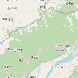
Map view of Itanagar Wildlife Sanctuary

Use this park location map to pinpoint Itanagar Wildlife Sanctuary in India, understand its exact geographic position, and read its mapped placement within the surrounding landscape more clearly.

Pigeon | © OpenStreetMap contributors

Location context for Itanagar Wildlife Sanctuary

Arunachal Pradesh
Park atlas

Compare regional hill forests and protected areas across the surrounding landscape

Parks Near Itanagar Wildlife Sanctuary and Other Protected Landscapes

Browsing other protected areas near Itanagar Wildlife Sanctuary reveals broader ecological patterns across the foothill terrain of Arunachal Pradesh. Comparing adjacent reserves helps contextualize the unique urban forest setting and diverse wildlife habitats of the region.
Watercolor painting of green hills, fields, and a body of water
National parkAssam
About 37 km away#1 closest

Southwest

Kaziranga National Park National Park: Protected Landscape and Geographic Atlas

Mapped boundaries and regional landscape context for this Assam natural area.

Delve into the detailed geographic profile of Kaziranga National Park, a prominent National Park located in Assam, India. This section focuses on its mapped protected area extent, its unique landscape characteristics within the Brahmaputra valley, and its role as a key natural landmark in northeastern India's atlas. Understand the structured geographic data and protected land identity that makes Kaziranga National Park a distinct entity for exploration.

Area
1,090 km²
Established
1905
IUCN
II
Relief
Lowland
Wildlife reserveArunachal Pradesh
About 62 km away#2 closest

Northeast

Talle Valley Wildlife Sanctuary, Arunachal Pradesh: Protected Area and Forest Map

A vital Himalayan sanctuary of vertical forest gradients

Spanning from 1,200 to 3,000 meters in elevation, Talle Valley Wildlife Sanctuary contains a dense mosaic of broadleaf and conifer forests. This reserve in the Subansiri basin provides essential habitat for clouded leopards, hornbills, and various rare Himalayan plants, representing a significant study in biogeographic transition zones.

Area
337 km²
Established
1995
IUCN
IV
Relief
Mountain
National parkSonitpur
About 79 km away#3 closest

West

Nameri National Park: A Protected Landscape within Sonitpur's Geography

Explore the mapped terrain and national park boundaries.

Nameri National Park represents a significant protected natural area, contributing to the regional geography of Sonitpur, India. This page offers an atlas-oriented perspective, detailing the park's mapped landscape and its designation as a national park. Understand the geographic context and the protected land's specific identity within this mapped region.

Area
200 km²
Established
1978
IUCN
II
Relief
Mountain
Wildlife reserveAssam
About 108 km away#4 closest

Southwest

Bura Chapori Wildlife Sanctuary: Protected Grassland Geography in the Brahmaputra Valley

A vital wildlife reserve and buffer area within Assam's floodplain ecosystem.

Located in the Sonitpur district of Assam, Bura Chapori Wildlife Sanctuary offers a focused look at the Brahmaputra valley's dynamic floodplain environment. This protected area supports an essential mosaic of open grasslands and riverine woodlands, serving as a critical corridor for large mammals and endangered grassland birds. Its geography is deeply influenced by the seasonal rhythms of the Brahmaputra River, shaping the sanctuary as both a wetland habitat and a key conservation link.

Area
44.06 km²
Established
1974
IUCN
IV
Relief
Lowland
Wildlife reserveArunachal Pradesh
About 108 km away#5 closest

West

Sessa Orchid Sanctuary: Himalayan Foothills Wildlife Reserve and Mapped Protected Landscape

High-altitude forest geography in Arunachal Pradesh

Sessa Orchid Sanctuary is a pivotal wildlife reserve spanning the rugged Himalayan foothills of West Kameng, Arunachal Pradesh. Defined by deep gorges and high ridges, the sanctuary protects one of the most significant orchid habitats in India, featuring over 200 distinct species within its closed-canopy monsoon forests. This protected area stands as a central link in the Kameng Protected Area Complex, representing a critical region for scientific research, endemic flora, and continuous forest conservation.

Area
100 km²
Established
1989
IUCN
IV
Relief
Mountain
Wildlife reserveWest Kameng
About 117 km away#6 closest

West

Eaglenest Wildlife Sanctuary: Geography and Protected Forest Atlas

Mapping the Eastern Himalayan foothills in West Kameng

Eaglenest Wildlife Sanctuary stands as a landmark of Indo-Burmese biodiversity conservation, spanning a dramatic altitudinal range that anchors the West Kameng forest complex. This wildlife reserve features dense bamboo stands, temperate ridges, and foothill forest corridors that provide a crucial environment for diverse mammal and bird species. The sanctuary remains a primary site for understanding the interaction between mountain topography and ecological connectivity in the Eastern Himalayas.

Area
218 km²
Established
1989
IUCN
IV
Visitors
75 annual
Wildlife reserveArunachal Pradesh
About 125 km away#7 closest

Northeast

Kane Wildlife Sanctuary: Geography, Forest Mosaics, and Protected Himalayan Terrain

A vital wildlife reserve located in the West Siang district of Arunachal Pradesh.

Kane Wildlife Sanctuary presents a compact yet meaningful protected area defined by its unique transition of tropical evergreen and temperate broadleaf forest types. This Himalayan reserve serves as a critical habitat for large mammals and diverse bird populations, offering a focused look at the varied terrain and regional biodiversity found within the foothills of northeastern India.

Area
31 km²
Established
1991
IUCN
IV
Relief
Upland
Wildlife reserveAssam
About 129 km away#8 closest

South

East Karbi-Anglong Wildlife Sanctuary: Geographic Overview and Hill Forest Map

Protected wildlife reserve within the Karbi Anglong district of Assam.

The East Karbi-Anglong Wildlife Sanctuary occupies a significant portion of the Karbi Anglong plateau, encompassing 222 square kilometers of rolling hills and narrow valleys. This protected area supports a mosaic of forest habitats, ranging from moist evergreen patches to drier deciduous ridges. It functions as an essential refuge for tigers, elephants, and primates, while maintaining a rich avian community of approximately 250 recorded species.

Area
221.81 km²
Established
2000
IUCN
IV
Relief
Upland

Common questions about visiting, size, designation, and location context for Itanagar Wildlife Sanctuary

Itanagar Wildlife Sanctuary FAQs for park facts, access, geography, and protected area context

Find quick answers about Itanagar Wildlife Sanctuary, including protected-area facts, park geography, trail and visitor context, and how the park fits into its surrounding country and regional landscape.
MoriAtlas Explorer

Continue Your Protected Areas Search Across the Global Atlas

Deepen your exploration by continuing the structured search for national parks and protected areas worldwide. Utilize the comprehensive filtering capabilities to compare different conservation landscapes and refine your understanding of global park geography. Discover more about the distribution and characteristics of protected natural areas.

Global natural geography