Mori Atlas logo
Wildlife reserveJumbo Springs Wilderness

A mapped exploration of Precambrian metamorphic formations, granitic domes, and desert spring systems.

Jumbo Springs Wilderness Protected Area and Geographic Atlas of Clark County Nevada

Jumbo Springs Wilderness encompasses a rugged desert landscape within Clark County, offering a protected refuge of rocky canyons and granitic outcrops overlooking Lake Mead. This wilderness preserve serves as a significant ecological transition zone where ancient metamorphic rocks and spring-fed microhabitats support diverse Mojave Desert flora. The terrain provides a compact study in arid geography, featuring dissected slopes and boulder fields that highlight the complex geological character of southern Nevada.

desert wildernessMojave DesertLake Mead areaBureau of Land Managementgranitic domesdesert springs

Jumbo Springs Wilderness

Wildlife reserve

Park overview

Structured park overview, official facts, and landscape profile for Jumbo Springs Wilderness

Jumbo Springs Wilderness park facts, protected area profile, and essential visitor context

Review the core facts for Jumbo Springs Wilderness, including designation, size, terrain, visitor scale, habitats, and operating context in one park-focused overview.

About Jumbo Springs Wilderness

Jumbo Springs Wilderness sits in the dry, sun-baked terrain of southern Nevada, in the part of Clark County where the Mojave Desert landscape climbs toward the shores of Lake Mead. Although the wilderness is small in absolute terms, its location along a critical transition zone between the Mojave Desert and the reservoir's riparian edge gives it outsized ecological interest. The protected area sits roughly 50 miles east of Las Vegas and connects directly to both the southern and eastern sides of Lake Mead, tying its own desert ecosystems into the broader network of protected lands around one of the largest man-made lakes in the United States.

Geologically, the wilderness is a showcase of deep time in miniature. The terrain includes ancient Precambrian metamorphic rocks alongside more recent granitic domes and scattered boulders, producing a rugged topography with several distinct microhabitats. This geological variety is matched by a corresponding diversity of plant communities, from creosote-covered flats and rocky slopes to pockets of vegetation sustained by the springs and seeps that give the area its name.

As a Bureau of Land Management wilderness area, Jumbo Springs is part of the National Wilderness Preservation System and is managed to preserve its wild, undeveloped character. Designation in 2002 reinforced protections for the area's natural values, including its wildlife, its fragile desert soil crusts, and its character as a quiet refuge in a region increasingly shaped by urban growth and reservoir-related recreation. The wilderness fits naturally alongside Lake Mead National Recreation Area in the network of protected landscapes of southern Nevada, acting as a smaller, complementary desert preserve.

Quick facts and research context for Jumbo Springs Wilderness

Jumbo Springs Wilderness is a 4,631 acre BLM-managed wilderness area in Clark County, Nevada, about 50 miles east of Las Vegas and adjacent to the southern and eastern sides of Lake Mead. It was designated as wilderness in 2002 and contains Precambrian metamorphic rocks alongside granitic domes and boulders. Native fauna includes coyotes, pocket gophers, and white-tailed antelope squirrels; native vegetation includes Nevada jointfir, cryptobiotic crusts, and buckhorn cholla.

Protection and recognition

Documented terrestrial protection scope and established designation year

Jumbo Springs Wilderness Protection Status and Designation History

Jumbo Springs Wilderness maintains a documented terrestrial protection scope established in the year 2002. Structured conservation records detail the official designation history and management framework associated with the protected area.

Protection details

Protection scope
Terrestrial
Designated year
2002
Transboundary protection
No
Park context

Deeper park guide and search-rich context for Jumbo Springs Wilderness

Jumbo Springs Wilderness history, landscape, wildlife, and travel context

Explore Jumbo Springs Wilderness through its history, landscape character, ecosystems, wildlife, conservation priorities, cultural context, and seasonal travel timing in a structured park guide built for atlas discovery and search intent.

Why Jumbo Springs Wilderness stands out

Jumbo Springs Wilderness is best known for its compact concentration of varied desert geology within a small BLM wilderness footprint above Lake Mead. Visitors and researchers value it for its Precambrian metamorphic formations, granitic domes, desert spring systems, and characteristic Mojave-desert flora and fauna. It is also notable as a relatively young wilderness designation, having received its protected status only in 2002.

Jumbo Springs Wilderness history and protected-area timeline

Jumbo Springs Wilderness received its formal wilderness designation in 2002, making it one of the more recently designated BLM wilderness areas in southern Nevada. The designation brought the area into the National Wilderness Preservation System and placed it under the management framework of the Bureau of Land Management, which is responsible for balancing conservation with limited, low-impact uses consistent with wilderness character. Prior to designation, the lands were part of the broader public domain context that was typical of Nevada BLM holdings, used historically for grazing and dispersed recreation. The 2002 designation reflected a national-era emphasis on protecting representative desert landscapes, particularly small but ecologically rich parcels near iconic features such as Lake Mead.

Jumbo Springs Wilderness landscape and geographic character

The landscape of Jumbo Springs Wilderness is shaped by the rugged geology of the eastern Mojave Desert. The terrain ranges across rocky slopes, boulder fields, and exposed ridgelines, with granitic domes rising above more broken, dissected ground. Underlying much of the area are ancient Precambrian metamorphic rocks, which combine with the granitic features to produce a visually varied surface that is unusually rich for a small wilderness.

The presence of springs and seep zones adds a softer element to an otherwise harsh setting, supporting localized pockets of denser vegetation amid the surrounding arid slopes. The wilderness opens eastward and southward toward Lake Mead, so the broader landscape context is one of dry desert mountains meeting one of the largest reservoirs in the United States. The result is a setting where desert cliffs, rocky drainages, and water-influenced microhabitats sit within a short distance of each other, contributing to topographic and scenic diversity within a compact footprint.

Jumbo Springs Wilderness ecosystems, habitats, and plant life

Jumbo Springs Wilderness preserves a representative slice of the eastern Mojave Desert ecosystem, with ecological patterns strongly tied to its rocky terrain and scattered water sources. The combination of slope, aspect, bedrock, and spring-influenced soils produces visible vegetation gradients across short distances, from harsh, bare rock and broken boulder fields to areas where jointfir, cholla, and other drought-adapted plants find enough footing and moisture to establish themselves.

A particularly important ecological feature is the presence of cryptobiotic crusts, the slow-growing communities of cyanobacteria, lichens, and mosses that stabilize desert soils. These crusts are highly vulnerable to disturbance and are a key indicator of the area's relatively intact condition. Together with the spring systems, they sustain a small but functioning desert food web that supports the wildlife of the area.

Jumbo Springs Wilderness wildlife and species highlights

Despite its small size, Jumbo Springs Wilderness supports a recognizable cast of Mojave-edge wildlife. Coyotes are among the notable mammalian predators, moving across the rocky terrain and around the spring systems in search of prey and water-adjacent opportunity. Smaller mammals are well represented by pocket gophers, which contribute to soil turnover in suitable pockets of vegetation, and white-tailed antelope squirrels, a species strongly associated with the warm, rocky desert environments of the southern Great Basin and northern Mojave.

The combination of mammals, scattered spring habitat, and varied terrain also supports a broader community of reptiles, birds, and smaller desert creatures typical of the region, though these are less individually documented. The wilderness functions as habitat linkage and refuge near Lake Mead, where wildlife movements between the reservoir corridor and the surrounding desert continue to play out under wilderness protections.

Jumbo Springs Wilderness conservation status and protection priorities

Jumbo Springs Wilderness contributes to conservation in southern Nevada by protecting a small but ecologically representative piece of the eastern Mojave Desert just outside one of the busiest recreation landscapes in the American Southwest, Lake Mead. Its 2002 inclusion in the National Wilderness Preservation System ensured that its Precambrian rock outcrops, granitic domes, spring systems, and fragile cryptobiotic soil crusts would be managed to maintain their wild character.

The area's conservation value is heightened by its proximity to urban Las Vegas and the heavily used Lake Mead shoreline. By keeping this portion of the desert roadless and undeveloped, the wilderness preserves habitat connectivity, protects sensitive desert surfaces from off-road vehicle and other human impacts, and provides a benchmark for studying intact Mojave ecosystems. Management under the Bureau of Land Management framework emphasizes minimal-impact uses consistent with preserving the area's natural and geological values.

Top sights and standout views in Jumbo Springs Wilderness

The strongest highlights of Jumbo Springs Wilderness are its compact geologic diversity and its role as a protected desert refuge next to Lake Mead. The mix of Precambrian metamorphic rocks with granitic domes and boulders creates a textured landscape that is unusually varied for such a small area. Its spring-fed microhabitats, fragile cryptobiotic soil crusts, and populations of characteristic Mojave species such as buckhorn cholla and white-tailed antelope squirrels round out its identity as a quiet but ecologically meaningful BLM wilderness.

Best time to visit Jumbo Springs Wilderness

As a low-elevation Mojave-edge desert wilderness, Jumbo Springs is most comfortably experienced during the cooler months of fall, winter, and early spring, when daytime temperatures are moderate and wildlife activity around springs and seeps tends to be more visible. Summer conditions in southern Nevada are extreme, with very high temperatures and intense sun exposure that make even short visits uncomfortable and potentially dangerous. Spring can offer the added attraction of wildflower and seasonal plant activity following winter rainfall, while fall typically brings stable, dry weather and clear visibility across the rugged terrain above Lake Mead.
Monthly climate preview

Long-term representative temperature and precipitation rhythms across twelve recorded intervals

Jumbo Springs Wilderness Climate Normals and Annual Weather Patterns

Jumbo Springs Wilderness exhibits a measured annual temperature range from mean lows below freezing up to average maximums exceeding forty degrees Celsius, paired with low daily precipitation across all recorded intervals. Reviewing the complete monthly climate dataset provides deeper comparative insight into long-term temperature swings and precipitation distribution.
Annual mean19 °C
7 °C33 °C
Jan
Feb10°
Mar14°
Apr18°
May24°
Jun30°
Jul33°
Aug32°
Sep27°
Oct20°
Nov12°
Dec
Warmest month
July

32.6 °C

Coolest month
December

6.9 °C

Wettest month
February

1.1 mm/day

Driest month
June

0.1 mm/day

Park location guide

Geography guide, regional context, and park location map for Jumbo Springs Wilderness

Jumbo Springs Wilderness park geography, regions, and map view in United States of America

Understand where Jumbo Springs Wilderness sits in United States of America through a broader geographic reading of the surrounding landscape, nearby location context, and its mapped position within the national park landscape.

How Jumbo Springs Wilderness fits into United States of America

The United States of America is a federal presidential republic and one of the world's largest countries by area and population. It consists of 50 states across a vast territory spanning multiple time zones, with its capital in Washington, D.C. and largest city in New York City. The nation has a diverse economy, influential political system, and significant cultural and military presence globally.

Wider geography shaping Jumbo Springs Wilderness in United States of America

The United States occupies a vast territory in North America, bordered by Canada to the north and Mexico to the south. The 48 contiguous states stretch from the Atlantic to the Pacific Ocean, while Alaska occupies the northwestern region and Hawaii is an archipelago in the Pacific. The country encompasses diverse terrain including the Rocky Mountains, Appalachian Mountains, Great Plains, and extensive river systems.

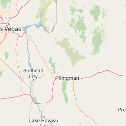
Map view of Jumbo Springs Wilderness

Use this park location map to pinpoint Jumbo Springs Wilderness in United States of America, understand its exact geographic position, and read its mapped placement within the surrounding landscape more clearly.

Pigeon | © OpenStreetMap contributors

Location context for Jumbo Springs Wilderness

Clark County
Park atlas

Compare regional protected areas and adjacent Mojave Desert wilderness geography.

Explore Parks Near Jumbo Springs Wilderness and Surrounding Desert Landscapes

Browse other protected areas near Jumbo Springs Wilderness to examine shared Mojave Desert terrain, granitic formations, and regional mountain ranges. Comparing adjacent desert landscapes provides broader context for southern Nevada wilderness conservation and arid ecosystem geography.
A watercolor painting showing a soft-toned landscape with a winding river in the foreground, a forested middle ground, and rolling mountains in the distance.
Protected landscapeUnited States of America
About 1.1 km away#1 closest

West

Lake Mead National Recreation Area: Desert Reservoir and Protected Landscape Atlas

United States protected geography and reservoir terrain

Spanning the lower Colorado River, Lake Mead National Recreation Area represents a unique convergence of desert ecosystems and large-scale water management. Its geography includes extensive reservoir shorelines, deep canyon corridors, and volcanic basin terrain that provide a foundational look at the arid environments of the American Southwest. The area remains a significant study of how engineered water features alter and interact with complex desert landscapes.

Area
6,053.31 km²
Established
1936
IUCN
V
Visitors
6.4M annual
National parkArizona
About 18 km away#2 closest

East

Grand Canyon National Park: Arizona National Park Protected Landscape & Geography

Explore mapped boundaries and regional atlas context.

Grand Canyon National Park stands as a premier national park, showcasing a unique protected landscape within Arizona's diverse geography. This detailed entry focuses on the park's specific geographic identity, its mapped boundaries, and its significance within the regional atlas. Discover the contours of this protected area and its place in the natural terrain of the American Southwest.

Area
4,926.08 km²
Established
1919
IUCN
II
Visitors
4.9M annual
A horizontal watercolor painting depicting soft desert hills in shades of green, yellow, and soft pink.
Wildlife reserveClark County
About 51 km away#3 closest

West

Muddy Mountains Wilderness: Geographic Atlas and Protected Desert Landscape Map

Exploration of sandstone terrain and Clark County topography.

Navigate the complex desert geography of the Muddy Mountains Wilderness, a protected area characterized by its vivid red cliffs, ancient cross-bedded sandstone, and steep elevation gains. This atlas entry provides essential context on the wilderness boundaries, regional landscape patterns, and environmental features that define this significant Mojave Desert refuge.

Area
194.87 km²
Established
2002
Relief
Mountain
Water
Minor water
Wildlife reserveNevada
About 65 km away#4 closest

West

Jimbilnan Wilderness: Geographic Overview and Protected Desert Landscape in Nevada

Mapping the canyons, washes, and plateaus of the Black Mountains

Jimbilnan Wilderness offers a dense mosaic of Mojave Desert habitats within a compact protected footprint. Located in Clark County, this Nevada wildlife reserve features a transition from deep, rocky canyons carved into the Black Mountains to wide desert washes and benches near Lake Mead. The area is notable for its botanical diversity, including rare milkvetch and buckwheat, serving as a critical link between upland desert systems and the lacustrine environment of the reservoir.

Area
76.4 km²
Established
2002
IUCN
Ib
Relief
Mountain
Wildlife reserveArizona
About 71 km away#5 closest

South

Mount Tipton Wilderness: Protected Mountain Geography in Northwestern Arizona

High desert ridgelines and summit forest ecosystems

Mount Tipton Wilderness protects a striking segment of the Cerbat Mountains, characterized by its elevation-driven transition from arid desert lowlands to cooler, forested peaks. This rugged Arizona landscape features narrow spine ridges and the notable rock formations of the Cerbat Pinnacles, offering a preserved backcountry environment for those exploring the region's mountain geology and desert ecosystems.

Area
124.5 km²
Established
1990
IUCN
Ib
Relief
Mountain
Wildlife reserveNevada
About 88 km away#6 closest

Southwest

Ireteba Peaks Wilderness: Protected Desert Mountains and Lake Mohave Reservoir Shoreline

Mapping the Eldorado Mountains within southern Nevada desert protected areas.

Spanning the southern Eldorado Mountains and the northern shores of Lake Mohave, Ireteba Peaks Wilderness represents a critical Mojave Desert protected area. This landscape integrates rugged, rocky ridgelines with arid desert slopes and reservoir inlets. Its geographic character, shaped by both federal wilderness designation and proximity to the Avi Kwa Ame National Monument, preserves a vital slice of Nevada desert terrain and native ecological habitat.

Area
132.51 km²
Established
2002
IUCN
Ib
Relief
Mountain
Watercolor painting of a forested landscape featuring pine trees and distant rolling mountains on a white background.
Wildlife reserveArizona
About 93 km away#7 closest

East

Mount Trumbull Wilderness: A Detailed Geographic Overview of Northern Arizona Volcanic Protected Lands

Mapping basalt mesas and cinder cone ecosystems on the Uinkaret Plateau

Mount Trumbull Wilderness represents a distinct volcanic protected area located on the Uinkaret Plateau of the Arizona Strip. This rugged wilderness encompasses a massive basalt-capped mesa, scattered cinder cones, and deep ecological gradients ranging from pinyon-juniper woodlands to ancient ponderosa forests, providing a vivid look at the complex geological history near the Colorado River.

Area
31 km²
Established
1984
IUCN
Ib
Relief
Mountain
Wildlife reserveArizona
About 113 km away#8 closest

South

Mount Nutt Wilderness: Mapping the Volcanic Canyons and Desert Landscapes of Arizona

A protected wilderness area in the central Black Mountains

Mount Nutt Wilderness offers a dramatic look at high desert topography, characterized by fortress-like volcanic formations and deeply incised canyons. This protected area in northwestern Arizona provides essential habitat for desert bighorn sheep while showcasing the contrast between sun-baked mesas and lush, spring-fed riparian zones.

Area
114 km²
Established
1990
IUCN
Ib
Water
Minor water

Common questions about visiting, size, designation, and location context for Jumbo Springs Wilderness

Jumbo Springs Wilderness FAQs for park facts, access, geography, and protected area context

Find quick answers about Jumbo Springs Wilderness, including protected-area facts, park geography, trail and visitor context, and how the park fits into its surrounding country and regional landscape.
MoriAtlas Explorer

Continue Your Protected Areas Search Across the Global Atlas

Deepen your exploration by continuing the structured search for national parks and protected areas worldwide. Utilize the comprehensive filtering capabilities to compare different conservation landscapes and refine your understanding of global park geography. Discover more about the distribution and characteristics of protected natural areas.

Global natural geography