
Mori Atlas logo
Regional parkJurapark Aargau

A detailed atlas of the protected tabular and folded Jura mountain terrain across Aargau

Jurapark Aargau: Exploring the Regional Park Geography and Protected Jura Mountain Landscapes

Jurapark Aargau represents a distinct regional nature park within the Jura mountain system, characterized by the geological transition between the northern tabular Tafeljura plateaus and the southern folded Kettenjura ridges. This protected landscape preserves diverse mixed forest ecosystems, fossil-rich limestone formations, and traditional agricultural structures between the metropolitan hubs of Zurich and Basel. Through this atlas entry, discover the mapped boundaries, tectonic features, and natural topography that define this significant Swiss conservation area.

regional nature parkSwitzerlandJuraAargauTafeljuraKettenjura
A flat-style digital illustration depicting a pastoral valley with green hills, a winding path, a small farmhouse, and a waterfall flowing down a mountain slope under a soft sunrise.

Jurapark Aargau

Regional park

Park overview

Structured park overview, official facts, and landscape profile for Jurapark Aargau

Jurapark Aargau park facts, protected area profile, and essential visitor context

Review the core facts for Jurapark Aargau, including designation, size, terrain, visitor scale, habitats, and operating context in one park-focused overview.

About Jurapark Aargau

Jurapark Aargau is a Swiss Regional Nature Park of National Significance that has, since 2012, brought together 31 communities in a rural stretch of the northern Jura between the metropolitan regions of Basel and Zurich. Covering about 299 square kilometers across the districts of Rheinfelden, Laufenburg, Aarau, and Brugg, the park unites a series of valleys in northwestern Aargau, including the Wegenstettertal, Fricktal, Böztal, Mettauertal, and Schenkenbergertal, under a single coordinated framework for landscape, nature, and cultural heritage management.

The park's purpose is to preserve and enhance a landscape that mixes extensive forests, traditional agricultural land, and small historic villages while supporting sustainable regional development. Forests rich in beech and pine, traditional high-st orchards, panoramic ridges, dry valleys, and the canton's highest waterfall at Sagimühlitäli together create a setting that is ecologically valuable, agriculturally productive, and accessible for close-to-home recreation. The park also functions as a connected refugium for native flora and fauna, providing green-space continuity between the densely populated regions on either side.

Geology shapes much of what visitors actually see. The northern half lies in the Tafeljura, characterized by relatively flat plateaus, gently rolling hills, and dry valleys, while the southern half reaches into the Kettenjura, where tectonic forces have produced dramatic escarpments, overthrusts, faults, and landslides. The limestone layers of the Jura are remnants of the former Tethys Sea and preserve fossils of ammonites, belemnites, and shellfish; the Frick area has also produced notable dinosaur bones, displayed in the Sauriermuseum Frick. Near Herznach and Wölflinswil, iron-bearing sedimentary layers of unusual thickness were mined until 1967, and the former mine at Herznach now serves both as a visitor attraction and as a small museum.

A core element of the park is its integration of cultural and natural heritage. Three federally inventoried landscapes of national significance fall partially inside the park perimeter: Baselbieter und Fricktaler Tafeljura, Aargauer und östlicher Solothurner Faltenjura, and Aargauer Tafeljura. These designations mark the area as one of the most scenically valuable rural regions in Switzerland. Combined with historic riverside old towns outside the strict park boundary, castle ruins, Roman-influenced vineyard terraces, and family-themed walking routes, the Jurapark Aargau offers a layered experience where paleontology, geology, traditional agriculture, and contemporary sustainable tourism meet.

Quick facts and research context for Jurapark Aargau

Jurapark Aargau is a Regional Nature Park of National Significance in Switzerland, formally designated in 2012 and part of the national network of Swiss Parks. The park covers approximately 299 square kilometers across 31 municipalities, 30 in the canton of Aargau and one in the canton of Solothurn, spanning the districts of Rheinfelden, Laufenburg, Aarau, and Brugg. It sits in the northwestern part of canton Aargau between the metropolitan areas of Zurich and Basel, framed by the Aare and Rhine rivers. Three federally protected landscapes of national significance fall partly within the park perimeter: Baselbieter and Fricktaler Tafeljura, Aargauer and eastern Solothurner Faltenjura, and Aargauer Tafeljura.

Protection and recognition

Analysis of terrestrial protected area designation and management history

Jurapark Aargau Protection Status and Documented Conservation Scope

Jurapark Aargau maintains a documented terrestrial protection scope without imported international recognition sources. Reviewing these verified administrative records clarifies the official conservation framework governing the protected landscape.

Protection details

Protection scope
Terrestrial
Transboundary protection
No
Park context

Deeper park guide and search-rich context for Jurapark Aargau

Jurapark Aargau history, landscape, wildlife, and travel context

Explore Jurapark Aargau through its history, landscape character, ecosystems, wildlife, conservation priorities, cultural context, and seasonal travel timing in a structured park guide built for atlas discovery and search intent.

Why Jurapark Aargau stands out

Jurapark Aargau is best known for its combination of a richly forested Jura landscape and a living rural cultural landscape set between two major Swiss metropolitan regions. Its defining identity comes from the contrast between the tabular Tafeljura, with plateaus and dry valleys, and the folded Kettenjura, with steep escarpments, tectonic breaks, and landslides, all rooted in the fossil-rich sediments of the ancient Tethys Sea. The park is also widely recognized for its paleontological heritage, especially the dinosaur finds around Frick, and for the iron-bearing Jurassic layers near Herznach, once among the thickest in Switzerland. Visitors associate it with panoramic high-level trails, the Fricktaler Höhenweg with its Cheisacher tower viewpoint, traditional high-st orchards, and the canton's highest waterfall in the Sagimühlitäli.
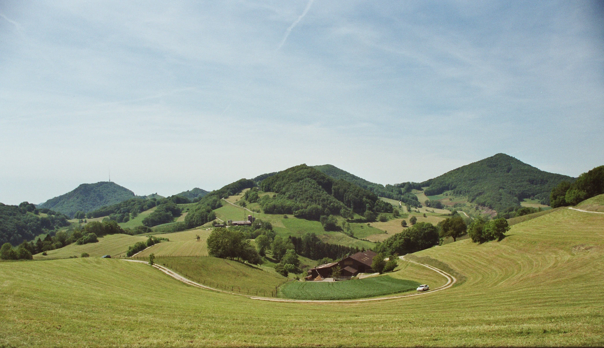
A wide landscape view of rolling green hills, forests, and grassy meadows with a winding road and a small building in the distance under a blue sky.
Rolling hills and agricultural landscape surrounding the Staffelegg pass in Jurapark Aargau.

Jurapark Aargau history and protected-area timeline

Jurapark Aargau was formally designated in 2012 as a Regional Nature Park of National Significance under Swiss federal law on nature and heritage protection. The designation brought together 30 municipalities in the canton of Aargau and one in the canton of Solothurn into a single coordinated park perimeter of roughly 299 square kilometers, within the framework of the national network of Swiss Parks. The park's creation built on long-standing recognition of the area's landscape and cultural value, and three federally inventoried landscapes of national significance already fell partly within its perimeter: Baselbieter and Fricktaler Tafeljura, Aargauer and eastern Solothurner Faltenjura, and Aargauer Tafeljura.

Beyond its modern administrative history, the area has a much longer human and geological story. The Jurassic limestone formations record the sediments of the ancient Tethys Sea, preserving ammonites, belemnites, shells, and other marine fossils; the Frick region has produced dinosaur remains that are now central to local identity and to the Sauriermuseum Frick. Iron-bearing layers near Herznach and Wölflinswil, some of the thickest such deposits in Switzerland, were actively mined until 1967, leaving a tangible industrial heritage now partly preserved through the Herznach mine and its associated museum. The region's older cultural landscape, shaped by traditional agriculture, orchards, and historic villages, also predates the park's founding and forms the everyday living environment that the park framework was designed to protect.

Jurapark Aargau landscape and geographic character

The landscape of Jurapark Aargau is shaped by the geological contrast between two parts of the Jura mountain system. In the north, the terrain belongs to the Tafeljura, where flat-lying limestone layers produce broad plateaus, gently rolling hills, and dry valleys that have long supported mixed agricultural use. In the south, the land rises into the Kettenjura, where tectonic folding has created steeper ridges, sharp rock edges, thrust faults, and active landslide zones, producing some of the park's most dramatic scenery. Between them lie the valleys of Wegenstettertal, Fricktal, Böztal, Mettauertal, and Schenkenbergertal, which together define much of the park's everyday rural character.

The park's elevations and ridges host several notable viewpoints and linear features. The Fricktaler Höhenweg runs along the high ground of the Fricktal region and provides panoramic outlooks, including the view from the viewing tower on the Cheisacherhöhe. Other scenic highlights include the Staffelegg pass and the highest waterfall of the canton of Aargau, located in the Sagimühlitäli, as well as the Linner Linde, a notable large linden tree that has become a landmark for hikers. Together, plateaus, ridges, valleys, and forested slopes create a varied topography within a compact area, supporting both agriculture and forest cover across nearly the entire park.

Jurapark Aargau ecosystems, habitats, and plant life

Jurapark Aargau encompasses a high proportion of green space, dominated by extensive mixed forests interspersed with farmland, traditional orchards, and small settlements. The forest cover is characterized by beech and Scots pine communities that thrive on the calcareous Jura soils, together with ecologically valuable edge habitats, dry valleys, and semi-open agricultural landscapes. These forests are not isolated patches but part of a continuously wooded countryside that connects the Aare valley to the Rhine valley, providing important continuity for plant and animal populations.

Beyond the forests, the park protects a rich mosaic of rural habitats, including high-st orchards, meadow edges, dry grassland corridors, and small valley streams. This mosaic supports a broad spectrum of native flora and fauna and gives the park its identity as a large, ecologically connected refuge in a densely populated part of Switzerland. The Jurassic bedrock itself contributes to habitat diversity: thin, stony soils on dry plateaus and richer, moister soils in folded valleys create very different plant communities within a short distance, while old mining and quarrying sites near Herznach and Frick add further ecological uniqueness.

Jurapark Aargau wildlife and species highlights

The extensive forests and structurally diverse rural landscape of Jurapark Aargau support a wide range of native fauna typical of the Jura region. Continuous woodland cover along the Aare–Rhine axis offers habitat for forest-dwelling mammals, breeding and migratory birds, and a variety of smaller species that benefit from the close interplay of woodland edge, orchard, and meadow. Traditional high-st orchards within the park are particularly important for cavity-nesting birds, bats, and a range of invertebrates that depend on old trees and the open spaces around them.

The park is also closely tied to the paleontological side of wildlife heritage. The Jurassic sediments of the area have yielded fossil ammonites, belemnites, marine shells, and dinosaur remains, with the Frick area in particular producing important finds that are displayed in the Sauriermuseum Frick and actively used in the Klopfplatz public fossil-splitting site. These paleontological resources, while not part of the living ecosystem, are a defining feature of how the park connects wildlife, geology, and its local identity.

Jurapark Aargau conservation status and protection priorities

As a Regional Nature Park of National Significance, Jurapark Aargau is part of the Swiss federal framework for protecting landscapes, habitats, and cultural heritage. Its conservation role is rooted in the Swiss constitution and the federal law on nature and heritage protection, which define Regional Nature Parks as larger, partly inhabited rural areas of high natural and scenic value where sustainable development measures are coordinated across municipalities. The park's perimeter includes portions of three nationally inventoried landscapes: Baselbieter and Fricktaler Tafeljura, Aargauer and eastern Solothurner Faltenjura, and Aargauer Tafeljura, giving it formal national-level recognition.

The park's conservation significance lies less in strict wilderness protection and more in maintaining a large, connected working landscape. By coordinating land use across 31 communities, the park aims to preserve and enhance forest quality, traditional orchards, dry valley habitats, and the mosaic of small-scale agricultural features that support biodiversity. It also integrates the protection of geological heritage sites such as the Herznach iron mine and the Frick dinosaur localities into a broader framework that combines habitat conservation, cultural landscape management, and sustainable tourism development.

Jurapark Aargau cultural meaning and human context

The cultural context of Jurapark Aargau is shaped by long-established rural communities whose traditional land use has produced much of what is now valued as park landscape. The 31 municipalities within the park span the districts of Rheinfelden, Laufenburg, Aarau, and Brugg, and include one community in the canton of Solothurn; their villages, farms, high-st orchards, and vineyards form a continuous cultural landscape between the Aare and Rhine rivers. This setting reflects the broader character of the Swiss Jura, where forestry, small-scale agriculture, and historic settlement patterns have evolved together over centuries.

Beyond the working landscape, the park's cultural identity includes tangible built and geological heritage. Historic old towns along the Rhine, castle ruins, Roman-influenced vineyard terraces known as Römerrebberge, traditional craft sites such as the Nagelschmiede Sulz, and themed walking trails like the Flösserweg and the family-oriented Perimukwege all draw on this rural and historical context. Industrial heritage is also part of the story: iron ore was mined near Herznach and Wölflinswil until 1967, and the former mine at Herznach now operates as both a visitor mine and a small museum, linking the area's geological past to its present-day cultural offering.

Top sights and standout views in Jurapark Aargau

The strongest distinctive features of Jurapark Aargau are its dual geological character and its rich cultural-rural landscape. The Tabular and Folded Jura meet within the park, producing both gentle high plateaus and steep, faulted escarpments along the same short distance. This same landscape records a remarkable natural history: ammonites, belemnites, marine shells, and the famous Frick dinosaur finds, as well as the unusually thick iron-bearing layers that were mined for over a century near Herznach. The Fricktaler Höhenweg with its Cheisacher tower, the canton's highest waterfall at Sagimühlitäli, and the historic Linner Linde together provide accessible, high-quality outdoor experiences. At the same time, traditional high-st orchards, Roman-era vineyard terraces, historic villages, and themed family walking routes show how living rural culture remains central to what the park is.

Best time to visit Jurapark Aargau

Jurapark Aargau is shaped by the temperate climate of the northern Swiss Jura, with four clearly distinguishable seasons that each set a different tone for visits. Spring brings fresh green growth in the beech and pine forests and awakening orchard meadows, ideal for those interested in wildflowers and early bird activity along the valleys and higher plateaus.

Summer offers the most reliable conditions for longer hikes along the Fricktaler Höhenweg and other ridge trails, with panoramic viewpoints such as the Cheisacher tower accessible in full daylight. Autumn is particularly attractive for those interested in the cultural landscape, when traditional orchards and deciduous forest stands change color and cultural events tied to the harvest are common. Winter tends to be quieter and can bring snow to the higher elevations, but much of the park remains suitable for low-level walking; conditions can be more variable, so visitors interested in specific routes should plan accordingly.

Monthly climate preview

Long-term temperature and precipitation records measured across representative coordinate elevations

Jurapark Aargau Climate Normals and Monthly Weather Statistics

Jurapark Aargau exhibits a measured annual climate rhythm ranging from winter mean temperatures below freezing to summer maximums approaching thirty degrees Celsius with steady precipitation throughout the year. Reviewing the complete monthly profile provides deeper historical context for understanding long-term temperature variation and regional precipitation patterns.
Annual mean9 °C
-1 °C18 °C
Jan-1°
Feb
Mar
Apr
May13°
Jun17°
Jul18°
Aug18°
Sep14°
Oct
Nov
Dec
Warmest month
July

18.3 °C

Coolest month
January

-0.6 °C

Wettest month
May

4 mm/day

Driest month
February

2.3 mm/day

Park location guide

Geography guide, regional context, and park location map for Jurapark Aargau

Jurapark Aargau park geography, regions, and map view in Switzerland

Understand where Jurapark Aargau sits in Switzerland through a broader geographic reading of the surrounding landscape, nearby location context, and its mapped position within the national park landscape.

How Jurapark Aargau fits into Switzerland

Switzerland is a landlocked federal republic in Central Europe comprising 26 cantons, with Bern as the federal city and Zurich as the largest city. The country features the Swiss Alps, Swiss Plateau, and Jura Mountains, with German, French, Italian, and Romansh as official languages. It is noted for its political neutrality, direct democracy traditions, and strong economy.

Wider geography shaping Jurapark Aargau in Switzerland

Switzerland is located in Central Europe at the intersection of Western and Southern Europe. It is bordered by Germany to the north, France to the west, Austria and Liechtenstein to the east, and Italy to the south. The country is geographically divided among the Swiss Alps (covering most of the territory), the Swiss Plateau (where most of the population resides), and the Jura Mountains. Switzerland is landlocked.

Map view of Jurapark Aargau

Use this park location map to pinpoint Jurapark Aargau in Switzerland, understand its exact geographic position, and read its mapped placement within the surrounding landscape more clearly.

Pigeon | © OpenStreetMap contributors

Location context for Jurapark Aargau

Aargau

Visual reference of the Jura mountain range, mixed forests, and protected rural habitats

Jurapark Aargau Photos, Landscapes, and Protected Mountain Scenery

Visual documentation captures the complex terrain of Jurapark Aargau, ranging from the flat plateaus of the northern tabular Jura to the folded escarpments and forested ridges of the south. Examining these protected landscapes reveals the distinctive habitats, rural heritage, and geological formations that define the Swiss regional nature park.

A wide landscape view of rolling green hills, forests, and grassy meadows with a winding road and a small building in the distance under a blue sky.

Park atlas

Compare regional protected landscapes and neighboring Jura nature reserves

Other Parks and Protected Areas Near Jurapark Aargau

Continue exploring regional protected landscapes and nature reserves located close to Jurapark Aargau. Comparing nearby protected areas provides valuable geographic context for understanding the broader Jura mountain terrain.
A watercolor painting showing a soft, impressionistic landscape with rolling green hills, forest patches, and pale distant mountains under a light sky.
Protected landscapeBaden-Württemberg
About 13 km away#1 closest

Northwest

Obersäckingen Protected Landscape: Regional Geography and Map Context in Baden-Württemberg

A preserved mosaic of southern Black Forest meadows and mixed woodland habitats

Located in the Waldshut district, the Obersäckingen protected landscape showcases a balanced environmental mosaic of oat-grass meadows, hedgerows, and field copses. This area serves as a key piece of the regional conservation network, closely overlapping with the Murg zum Hochrhein Natura 2000 site to maintain the visual and ecological character of the southern Black Forest countryside.

Area
0.415 km²
Established
2004
IUCN
V
Nature reserveAargau
About 17 km away#2 closest

Northeast

Klingnauer Stausee Nature Reserve: Aargau Wetland and Aare River Floodplain Landscapes

Protected riparian habitat in the northern Swiss Jura

Klingnauer Stausee stands as a primary example of integrated hydropower and conservation. This artificial reservoir and its surrounding wetlands, located in the Aargau region, encompass a variety of protected habitats ranging from open still waters to alluvial forests. These landscapes provide essential refuge for migratory waterbirds and preserve unique remnants of the historical Aare River floodplain structure.

Area
1.16 km²
Established
1935
Relief
Lowland
Climate
Temperate
Watercolor painting of a river landscape with lush green riverbanks, patches of grass in the foreground, and gentle rolling hills in the background.
Protected landscapeAargau
About 18 km away#3 closest

Northeast

Aarelandschaft bei Klingnau: A Protected Riverine Landscape in Northern Switzerland

Wetland geography, alluvial forests, and floodplain corridors

The Aarelandschaft bei Klingnau preserves a unique riverine mosaic where the Aare River meets the Rhine in northern Aargau. This protected landscape encompasses the Klingnauer Stausee reservoir, rich alluvial forests, and remnant oxbows. It serves as a vital migratory node for avian populations and provides a structured look at the interplay between human-engineered power infrastructure and protected natural river channels.

Area
3.6 km²
Established
1996
IUCN
V
Relief
Lowland
Protected landscapeBaden-Württemberg
About 21 km away#4 closest

Northwest

Südwestlicher Dinkelberg Protected Landscape and Dinkelberg Plateau Geography

Karst terrain and forest habitats in Baden-Württemberg

Located in the Lörrach district, Südwestlicher Dinkelberg protects a diverse mix of ravine forests, dry grasslands, and mires. The area preserves essential ecological corridors within the Lörrach-Basel region, showcasing complex geological features such as stream sinks and dry valleys that define the plateau edge.

Area
13.89 km²
Established
2013
IUCN
V
Relief
Upland
A horizontal watercolor painting depicting a landscape with soft rolling hills, green meadows, and wild grasses under a pale sky.
Nature reserveBaden-Württemberg
About 26 km away#5 closest

Northwest

Dinkelberg und Röttler Wald: Geographic Overview of this Baden-Württemberg Nature Reserve

Protected karst landscapes and mature beech forest habitat

Uncover the ecological and physical geography of Dinkelberg und Röttler Wald, a protected area stretching across diverse limestone plateaus and sandstone slopes in Germany. This site offers a valuable look at managed cultural landscapes that bridge the gap between rural meadows and wild forest reserves, providing critical habitat for European bat populations and rare flora across its varied elevational zones.

Area
46.47 km²
Established
2015
A horizontal watercolor painting of a winding river flowing through green rolling hills and wooded areas, with soft-colored mountain silhouettes in the background.
Protected landscapeSwitzerland
About 30 km away#6 closest

Southwest

Aareknie Wolfwil-Wynau: Geographic Profile of a Swiss Protected River Landscape

Mapping dynamic river bends and lowland floodplains in the Swiss Mittelland.

Aareknie Wolfwil-Wynau preserves a rare, non-engineered river reach where the Aare cuts through molasse rock. The area is defined by its active gravel bars, rapids, and federally protected floodplain habitats. This site provides a critical look at how lowland river ecosystems function alongside historic cultural landmarks like the medieval church at Wynau.

Area
1.1 km²
Established
1996
Relief
Lowland
Climate
Temperate
Nature reserveBaden-Württemberg
About 32 km away#7 closest

Northeast

Blumberger Pforte und Mittlere Wutach: Protected Landscape and Gorge Geography

Nature reserve terrain and ecological atlas in Baden-Württemberg

This protected area captures the dramatic transition where the Wutach river cuts through limestone strata. Discover a rugged landscape mosaic featuring canyon forests, juniper heaths, and karst cave systems across the Swabian Alb and Black Forest fringe. The site offers significant value for understanding regional ecological gradients and limestone-dependent plant communities within the broader southern German geography.

Area
63.25 km²
Established
2019
A soft watercolor painting depicting a gentle, rolling landscape with green hills, forests, and abstract meadows against a white background.
Regional parkSolothurn
About 34 km away#8 closest

Southwest

Regionaler Naturpark Thal: Protected Jura Landscapes and Regional Geography in Solothurn

Examining the folded ridges and pastoral terrain of the Swiss Jura

The Regionaler Naturpark Thal encompasses the entire Thal district, presenting a cohesive regional environment defined by the eastern Jura chain. This protected area features a unique mosaic of cattle-grazed heights, biodiversity-rich dry meadows, and dense mixed forests that anchor the Solothurn landscape. The terrain showcases the classic Jura topography of parallel ridges, secluded valleys, and dramatic klus incisions, providing a rich area for understanding regional mountain ecology.

Area
139 km²
Established
2009
Relief
Mountain
Climate
Temperate

Common questions about visiting, size, designation, and location context for Jurapark Aargau

Jurapark Aargau FAQs for park facts, access, geography, and protected area context

Find quick answers about Jurapark Aargau, including protected-area facts, park geography, trail and visitor context, and how the park fits into its surrounding country and regional landscape.
MoriAtlas Explorer

Continue Your Protected Areas Search Across the Global Atlas

Deepen your exploration by continuing the structured search for national parks and protected areas worldwide. Utilize the comprehensive filtering capabilities to compare different conservation landscapes and refine your understanding of global park geography. Discover more about the distribution and characteristics of protected natural areas.

Global natural geography